Goliad County Sketch File 27

Print $20.00
- Digital $50.00
Goliad County Sketch File 27
Size: 19.0 x 24.4 inches
11568
Goliad County Sketch File 28

Print $20.00
- Digital $50.00
Goliad County Sketch File 28
Size: 18.9 x 15.5 inches
11569
Goliad County Sketch File 5

Print $6.00
- Digital $50.00
Goliad County Sketch File 5
Size: 15.9 x 10.2 inches
24218
Goliad County Sketch File 11

Print $40.00
- Digital $50.00
Goliad County Sketch File 11
Size: 13.4 x 12.5 inches
24228
Goliad County Sketch File 16

Print $40.00
- Digital $50.00
Goliad County Sketch File 16
Size: 13.4 x 15.8 inches
24247
Goliad County Sketch File 19

Print $10.00
- Digital $50.00
Goliad County Sketch File 19
Size: 12.9 x 8.0 inches
24260
Goliad County Sketch File 26a

Print $10.00
- Digital $50.00
Goliad County Sketch File 26a
Size: 12.8 x 8.3 inches
24321
Goliad County Sketch File 29

Print $2.00
- Digital $50.00
Goliad County Sketch File 29
Size: 12.6 x 8.0 inches
24326
Goliad County Sketch File 30

Print $40.00
- Digital $50.00
Goliad County Sketch File 30
Size: 13.0 x 15.0 inches
24327
Refugio County Sketch File 11

Print $6.00
- Digital $50.00
Refugio County Sketch File 11
Size: 8.0 x 8.2 inches
35260
Refugio County Sketch File 12

Print $4.00
- Digital $50.00
Refugio County Sketch File 12
Size: 8.0 x 12.8 inches
35263
Refugio County Sketch File 15

Print $4.00
- Digital $50.00
Refugio County Sketch File 15
Size: 11.3 x 7.7 inches
35268

Goliad County Boundary File 33

Print $12.00
- Digital $50.00
Goliad County Boundary File 33
Size: 9.4 x 4.2 inches
53797
Goliad County Working Sketch 1

Print $20.00
- Digital $50.00
Goliad County Working Sketch 1
Size: 23.7 x 39.9 inches
63191
Victoria County Rolled Sketch 9

Print $20.00
- Digital $50.00
Victoria County Rolled Sketch 9
Size: 24.1 x 36.2 inches
95399
Victoria County Rolled Sketch 9

Print $20.00
- Digital $50.00
Victoria County Rolled Sketch 9
Size: 24.1 x 36.1 inches
95400
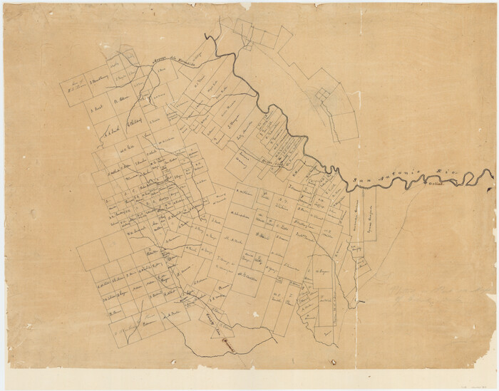
[Surveys in McMullen and McGloin's Colony along the San Antonio River]
Print $20.00
- Digital $50.00
[Surveys in McMullen and McGloin's Colony along the San Antonio River]
1828
Size: 19.3 x 24.5 inches
30
[Surveys in Power and Hewetson's Colony]
Print $20.00
- Digital $50.00
[Surveys in Power and Hewetson's Colony]
1830
Size: 21.3 x 22.5 inches
2
[Surveys in Power and Hewetson's Colony along the Aransas River, Middle Creek, Papalose Creek, and Blanco Creek]
Print $20.00
- Digital $50.00
[Surveys in Power and Hewetson's Colony along the Aransas River, Middle Creek, Papalose Creek, and Blanco Creek]
1830
Size: 21.6 x 21.2 inches
81
[Surveys in Power and Hewetson's Colony along the Blanco and Medina Rivers]
Print $20.00
- Digital $50.00
[Surveys in Power and Hewetson's Colony along the Blanco and Medina Rivers]
1834
Size: 37.0 x 29.9 inches
46
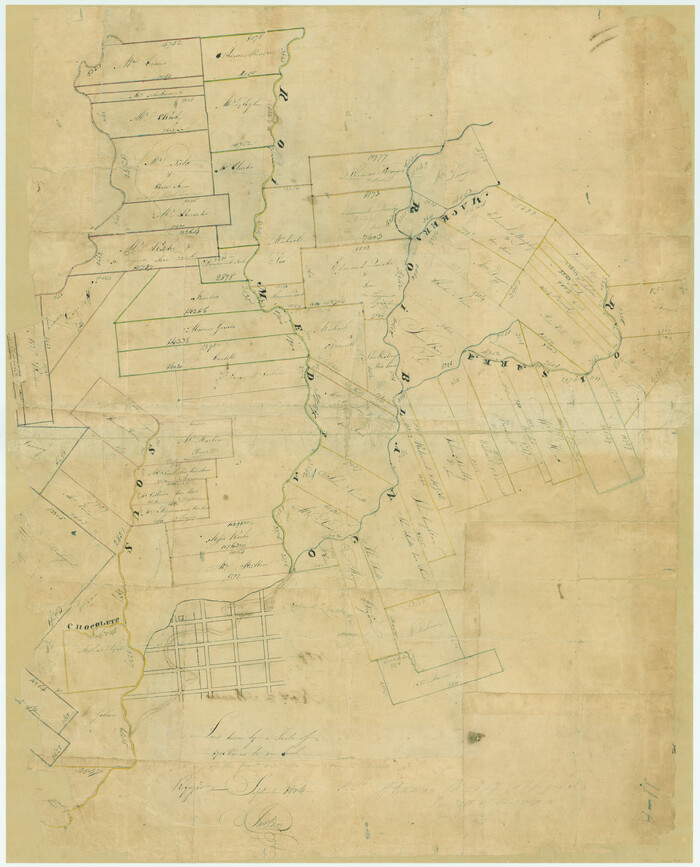
Surveys on the Coleto Creek, Goliad County

Print $20.00
- Digital $50.00
Surveys on the Coleto Creek, Goliad County
1841
Size: 13.8 x 14.9 inches
10
Map of Bexar County

Print $40.00
- Digital $50.00
Map of Bexar County
1845
Size: 90.6 x 81.0 inches
82242
Map of Bexar County

Print $20.00
- Digital $50.00
Map of Bexar County
1845
Size: 47.4 x 44.9 inches
87234
Map of Bexar County

Print $20.00
- Digital $50.00
Map of Bexar County
1845
Size: 47.5 x 41.7 inches
87235
Map of Bexar County

Print $40.00
- Digital $50.00
Map of Bexar County
1845
Size: 49.0 x 46.5 inches
87236
Map of Bexar County

Print $40.00
- Digital $50.00
Map of Bexar County
1845
Size: 48.8 x 43.0 inches
87237
Goliad County Sketch File 42a

Print $4.00
- Digital $50.00
Goliad County Sketch File 42a
1845
Size: 13.3 x 8.2 inches
24353
Goliad County Sketch File 42

Print $8.00
- Digital $50.00
Goliad County Sketch File 42
1847
Size: 13.0 x 8.2 inches
24349
Goliad County Sketch File 8

Print $4.00
- Digital $50.00
Goliad County Sketch File 8
1848
Size: 9.0 x 11.1 inches
24221
Goliad County Sketch File 27
Print $20.00
- Digital $50.00
Goliad County Sketch File 27
-
Size
19.0 x 24.4 inches
-
Map/Doc
11568
Goliad County Sketch File 28
Print $20.00
- Digital $50.00
Goliad County Sketch File 28
-
Size
18.9 x 15.5 inches
-
Map/Doc
11569
Goliad County Sketch File 5
Print $6.00
- Digital $50.00
Goliad County Sketch File 5
-
Size
15.9 x 10.2 inches
-
Map/Doc
24218
Goliad County Sketch File 11
Print $40.00
- Digital $50.00
Goliad County Sketch File 11
-
Size
13.4 x 12.5 inches
-
Map/Doc
24228
Goliad County Sketch File 16
Print $40.00
- Digital $50.00
Goliad County Sketch File 16
-
Size
13.4 x 15.8 inches
-
Map/Doc
24247
Goliad County Sketch File 19
Print $10.00
- Digital $50.00
Goliad County Sketch File 19
-
Size
12.9 x 8.0 inches
-
Map/Doc
24260
Goliad County Sketch File 26a
Print $10.00
- Digital $50.00
Goliad County Sketch File 26a
-
Size
12.8 x 8.3 inches
-
Map/Doc
24321
Goliad County Sketch File 29
Print $2.00
- Digital $50.00
Goliad County Sketch File 29
-
Size
12.6 x 8.0 inches
-
Map/Doc
24326
Goliad County Sketch File 30
Print $40.00
- Digital $50.00
Goliad County Sketch File 30
-
Size
13.0 x 15.0 inches
-
Map/Doc
24327
Refugio County Sketch File 11
Print $6.00
- Digital $50.00
Refugio County Sketch File 11
-
Size
8.0 x 8.2 inches
-
Map/Doc
35260
Refugio County Sketch File 12
Print $4.00
- Digital $50.00
Refugio County Sketch File 12
-
Size
8.0 x 12.8 inches
-
Map/Doc
35263
Refugio County Sketch File 15
Print $4.00
- Digital $50.00
Refugio County Sketch File 15
-
Size
11.3 x 7.7 inches
-
Map/Doc
35268
Goliad County Boundary File 33
Print $12.00
- Digital $50.00
Goliad County Boundary File 33
-
Size
9.4 x 4.2 inches
-
Map/Doc
53797
Goliad County Working Sketch 1
Print $20.00
- Digital $50.00
Goliad County Working Sketch 1
-
Size
23.7 x 39.9 inches
-
Map/Doc
63191
Victoria County Rolled Sketch 9
Print $20.00
- Digital $50.00
Victoria County Rolled Sketch 9
-
Size
24.1 x 36.2 inches
-
Map/Doc
95399
Victoria County Rolled Sketch 9
Print $20.00
- Digital $50.00
Victoria County Rolled Sketch 9
-
Size
24.1 x 36.1 inches
-
Map/Doc
95400
[Surveys in McMullen and McGloin's Colony along the San Antonio River]
Print $20.00
- Digital $50.00
[Surveys in McMullen and McGloin's Colony along the San Antonio River]
1828
-
Size
19.3 x 24.5 inches
-
Map/Doc
30
-
Creation Date
1828
[Surveys in Power and Hewetson's Colony]
Print $20.00
- Digital $50.00
[Surveys in Power and Hewetson's Colony]
1830
-
Size
21.3 x 22.5 inches
-
Map/Doc
2
-
Creation Date
1830
[Surveys in Power and Hewetson's Colony along the Aransas River, Middle Creek, Papalose Creek, and Blanco Creek]
Print $20.00
- Digital $50.00
[Surveys in Power and Hewetson's Colony along the Aransas River, Middle Creek, Papalose Creek, and Blanco Creek]
1830
-
Size
21.6 x 21.2 inches
-
Map/Doc
81
-
Creation Date
1830
[Surveys in Power and Hewetson's Colony along the Blanco and Medina Rivers]
Print $20.00
- Digital $50.00
[Surveys in Power and Hewetson's Colony along the Blanco and Medina Rivers]
1834
-
Size
37.0 x 29.9 inches
-
Map/Doc
46
-
Creation Date
1834
Surveys on the Coleto Creek, Goliad County
Print $20.00
- Digital $50.00
Surveys on the Coleto Creek, Goliad County
1841
-
Size
13.8 x 14.9 inches
-
Map/Doc
10
-
Creation Date
1841
Map of Bexar County
Print $40.00
- Digital $50.00
Map of Bexar County
1845
-
Size
90.6 x 81.0 inches
-
Map/Doc
82242
-
Creation Date
1845
Map of Bexar County
Print $20.00
- Digital $50.00
Map of Bexar County
1845
-
Size
47.4 x 44.9 inches
-
Map/Doc
87234
-
Creation Date
1845
Map of Bexar County
Print $20.00
- Digital $50.00
Map of Bexar County
1845
-
Size
47.5 x 41.7 inches
-
Map/Doc
87235
-
Creation Date
1845
Map of Bexar County
Print $40.00
- Digital $50.00
Map of Bexar County
1845
-
Size
49.0 x 46.5 inches
-
Map/Doc
87236
-
Creation Date
1845
Map of Bexar County
Print $40.00
- Digital $50.00
Map of Bexar County
1845
-
Size
48.8 x 43.0 inches
-
Map/Doc
87237
-
Creation Date
1845
Goliad County Sketch File 42a
Print $4.00
- Digital $50.00
Goliad County Sketch File 42a
1845
-
Size
13.3 x 8.2 inches
-
Map/Doc
24353
-
Creation Date
1845
Goliad County Sketch File 42
Print $8.00
- Digital $50.00
Goliad County Sketch File 42
1847
-
Size
13.0 x 8.2 inches
-
Map/Doc
24349
-
Creation Date
1847
Goliad County Sketch File 8
Print $4.00
- Digital $50.00
Goliad County Sketch File 8
1848
-
Size
9.0 x 11.1 inches
-
Map/Doc
24221
-
Creation Date
1848