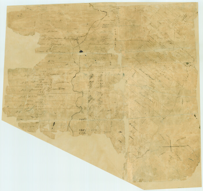
[Surveys in Power and Hewetson's Colony]
Print $20.00
- Digital $50.00
[Surveys in Power and Hewetson's Colony]
1830
Size: 21.3 x 22.5 inches
2
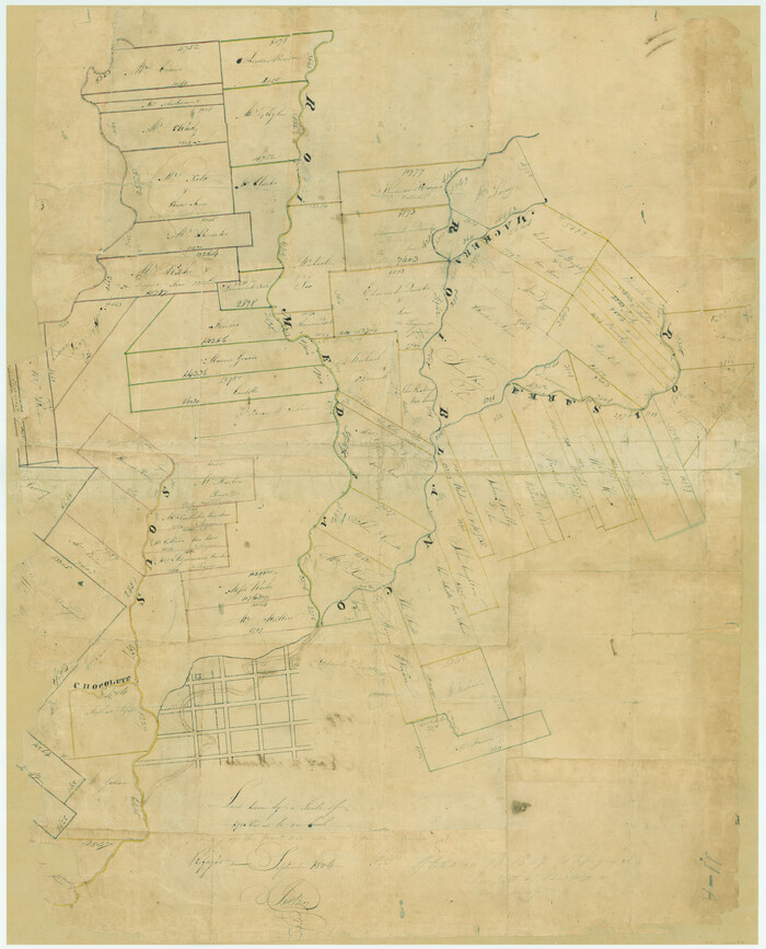
[Surveys in Power and Hewetson's Colony along the Blanco and Medina Rivers]
Print $20.00
- Digital $50.00
[Surveys in Power and Hewetson's Colony along the Blanco and Medina Rivers]
1834
Size: 37.0 x 29.9 inches
46
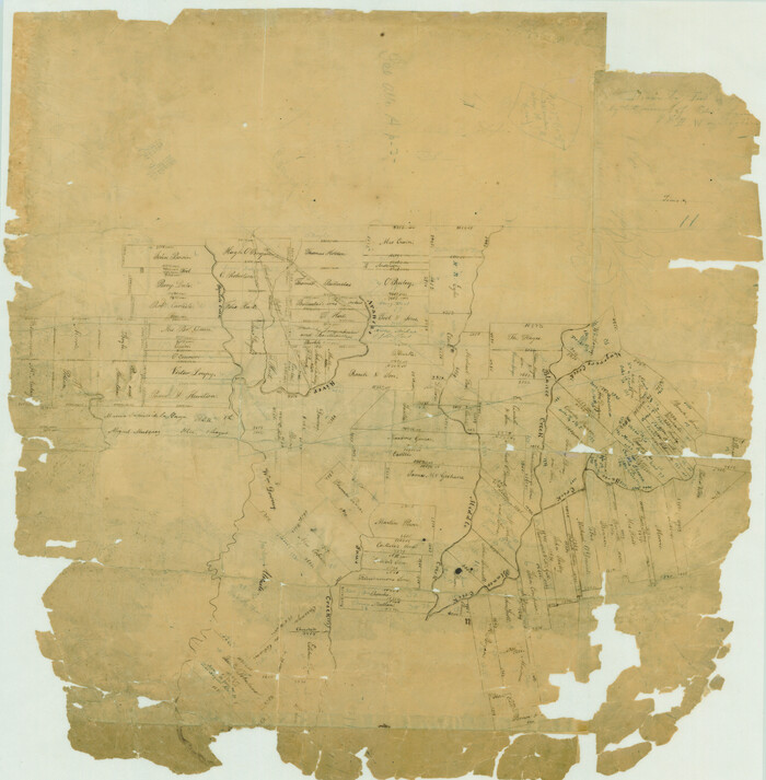
[Surveys in Power and Hewetson's Colony along the Aransas River, Middle Creek, Papalose Creek, and Blanco Creek]
Print $20.00
- Digital $50.00
[Surveys in Power and Hewetson's Colony along the Aransas River, Middle Creek, Papalose Creek, and Blanco Creek]
1830
Size: 21.6 x 21.2 inches
81
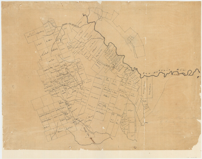
[Surveys in McMullen and McGloin's Colony along the San Antonio River]
Print $20.00
- Digital $50.00
[Surveys in McMullen and McGloin's Colony along the San Antonio River]
1828
Size: 19.3 x 24.5 inches
30
[Map] of Goliad Land District
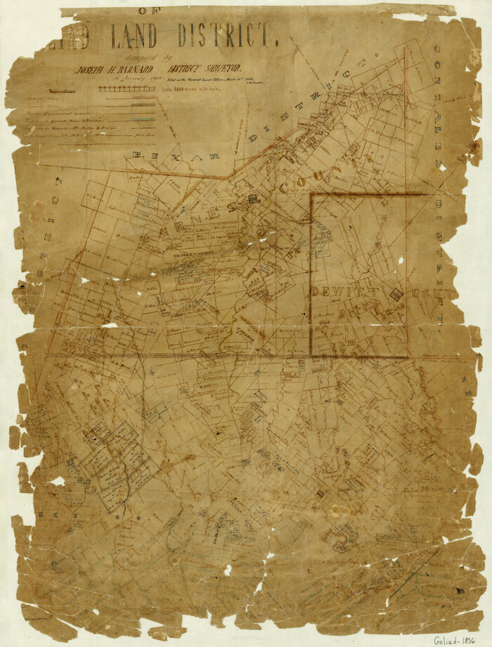
Print $20.00
- Digital $50.00
[Map] of Goliad Land District
1856
Size: 33.5 x 25.2 inches
3586
Working Sketch, Goliad & Bee Counties

Print $20.00
- Digital $50.00
Working Sketch, Goliad & Bee Counties
1936
Size: 35.0 x 43.1 inches
2453
Victoria County Sketch File 14

Print $10.00
- Digital $50.00
Victoria County Sketch File 14
2002
Size: 11.0 x 8.5 inches
95398
Victoria County Sketch File 12

Print $4.00
- Digital $50.00
Victoria County Sketch File 12
1978
Size: 11.4 x 8.9 inches
39540
Victoria County Rolled Sketch 9

Print $20.00
- Digital $50.00
Victoria County Rolled Sketch 9
Size: 24.1 x 36.2 inches
95399
Victoria County Rolled Sketch 9

Print $20.00
- Digital $50.00
Victoria County Rolled Sketch 9
Size: 24.1 x 36.1 inches
95400
Topographical Map of the country between San Antonio & Colorado Rivers in the State of Texas.

Print $40.00
Topographical Map of the country between San Antonio & Colorado Rivers in the State of Texas.
1864
Size: 53.2 x 74.8 inches
88606
The Republic County of Goliad. Proposed, Late Fall 1837-December 31, 1838

Print $20.00
The Republic County of Goliad. Proposed, Late Fall 1837-December 31, 1838
2020
Size: 15.1 x 21.7 inches
96148
The Republic County of Goliad. Proposed, Late Fall 1837

Print $20.00
The Republic County of Goliad. Proposed, Late Fall 1837
2020
Size: 15.1 x 21.7 inches
96147
The Republic County of Goliad. December 31, 1838

Print $20.00
The Republic County of Goliad. December 31, 1838
2020
Size: 15.1 x 21.7 inches
96149
The Republic County of Goliad. December 29, 1845

Print $20.00
The Republic County of Goliad. December 29, 1845
2020
Size: 17.5 x 21.7 inches
96152
The Republic County of Goliad. Boundaries Defined, December 2, 1841

Print $20.00
The Republic County of Goliad. Boundaries Defined, December 2, 1841
2020
Size: 17.5 x 21.7 inches
96151
The Republic County of Goliad. 1840

Print $20.00
The Republic County of Goliad. 1840
2020
Size: 15.1 x 21.7 inches
96150
Surveys on the Coleto Creek, Goliad County

Print $20.00
- Digital $50.00
Surveys on the Coleto Creek, Goliad County
1841
Size: 13.8 x 14.9 inches
10
Right of Way and Track Map, Galveston, Harrisburg & San Antonio Ry. operated by the T. & N. O. R.R. Co., Victoria Division, Rosenberg to Beeville

Print $40.00
- Digital $50.00
Right of Way and Track Map, Galveston, Harrisburg & San Antonio Ry. operated by the T. & N. O. R.R. Co., Victoria Division, Rosenberg to Beeville
1918
Size: 25.1 x 57.9 inches
76157
Right of Way and Track Map, Galveston, Harrisburg & San Antonio Ry. operated by the T. & N. O. R.R. Co., Victoria Division, Rosenberg to Beeville

Print $40.00
- Digital $50.00
Right of Way and Track Map, Galveston, Harrisburg & San Antonio Ry. operated by the T. & N. O. R.R. Co., Victoria Division, Rosenberg to Beeville
1918
Size: 24.4 x 57.9 inches
76158
Right of Way and Track Map, Galveston, Harrisburg & San Antonio Ry. operated by the T. & N. O. R.R. Co., Victoria Division, Rosenberg to Beeville

Print $40.00
- Digital $50.00
Right of Way and Track Map, Galveston, Harrisburg & San Antonio Ry. operated by the T. & N. O. R.R. Co., Victoria Division, Rosenberg to Beeville
1918
Size: 24.8 x 57.1 inches
76159
Right of Way and Track Map, Galveston, Harrisburg & San Antonio Ry. operated by the T. & N. O. R.R. Co., Victoria Division, Rosenberg to Beeville

Print $40.00
- Digital $50.00
Right of Way and Track Map, Galveston, Harrisburg & San Antonio Ry. operated by the T. & N. O. R.R. Co., Victoria Division, Rosenberg to Beeville
1918
Size: 25.4 x 57.5 inches
76160
Refugio County Working Sketch 4

Print $20.00
- Digital $50.00
Refugio County Working Sketch 4
1937
Size: 33.2 x 31.4 inches
63513
Refugio County Sketch File 15

Print $4.00
- Digital $50.00
Refugio County Sketch File 15
Size: 11.3 x 7.7 inches
35268
Refugio County Sketch File 12

Print $4.00
- Digital $50.00
Refugio County Sketch File 12
Size: 8.0 x 12.8 inches
35263
Refugio County Sketch File 11

Print $6.00
- Digital $50.00
Refugio County Sketch File 11
Size: 8.0 x 8.2 inches
35260
Map of Goliad County Texas

Print $20.00
- Digital $50.00
Map of Goliad County Texas
1879
Size: 19.1 x 21.2 inches
3589
Map of Goliad County Texas

Print $20.00
- Digital $50.00
Map of Goliad County Texas
1879
Size: 19.2 x 21.3 inches
4547
Map of Goliad County Texas

Print $20.00
- Digital $50.00
Map of Goliad County Texas
1879
Size: 19.5 x 21.8 inches
4548
Map of Goliad County

Print $20.00
- Digital $50.00
Map of Goliad County
1853
Size: 30.7 x 24.2 inches
3585
[Surveys in Power and Hewetson's Colony]
Print $20.00
- Digital $50.00
[Surveys in Power and Hewetson's Colony]
1830
-
Size
21.3 x 22.5 inches
-
Map/Doc
2
-
Creation Date
1830
[Surveys in Power and Hewetson's Colony along the Blanco and Medina Rivers]
Print $20.00
- Digital $50.00
[Surveys in Power and Hewetson's Colony along the Blanco and Medina Rivers]
1834
-
Size
37.0 x 29.9 inches
-
Map/Doc
46
-
Creation Date
1834
[Surveys in Power and Hewetson's Colony along the Aransas River, Middle Creek, Papalose Creek, and Blanco Creek]
Print $20.00
- Digital $50.00
[Surveys in Power and Hewetson's Colony along the Aransas River, Middle Creek, Papalose Creek, and Blanco Creek]
1830
-
Size
21.6 x 21.2 inches
-
Map/Doc
81
-
Creation Date
1830
[Surveys in McMullen and McGloin's Colony along the San Antonio River]
Print $20.00
- Digital $50.00
[Surveys in McMullen and McGloin's Colony along the San Antonio River]
1828
-
Size
19.3 x 24.5 inches
-
Map/Doc
30
-
Creation Date
1828
[Map] of Goliad Land District
Print $20.00
- Digital $50.00
[Map] of Goliad Land District
1856
-
Size
33.5 x 25.2 inches
-
Map/Doc
3586
-
Creation Date
1856
Working Sketch, Goliad & Bee Counties
Print $20.00
- Digital $50.00
Working Sketch, Goliad & Bee Counties
1936
-
Size
35.0 x 43.1 inches
-
Map/Doc
2453
-
Creation Date
1936
Victoria County Sketch File 14
Print $10.00
- Digital $50.00
Victoria County Sketch File 14
2002
-
Size
11.0 x 8.5 inches
-
Map/Doc
95398
-
Creation Date
2002
Victoria County Sketch File 12
Print $4.00
- Digital $50.00
Victoria County Sketch File 12
1978
-
Size
11.4 x 8.9 inches
-
Map/Doc
39540
-
Creation Date
1978
Victoria County Rolled Sketch 9
Print $20.00
- Digital $50.00
Victoria County Rolled Sketch 9
-
Size
24.1 x 36.2 inches
-
Map/Doc
95399
Victoria County Rolled Sketch 9
Print $20.00
- Digital $50.00
Victoria County Rolled Sketch 9
-
Size
24.1 x 36.1 inches
-
Map/Doc
95400
Topographical Map of the country between San Antonio & Colorado Rivers in the State of Texas.
Print $40.00
Topographical Map of the country between San Antonio & Colorado Rivers in the State of Texas.
1864
-
Size
53.2 x 74.8 inches
-
Map/Doc
88606
-
Creation Date
1864
The Republic County of Goliad. Proposed, Late Fall 1837-December 31, 1838
Print $20.00
The Republic County of Goliad. Proposed, Late Fall 1837-December 31, 1838
2020
-
Size
15.1 x 21.7 inches
-
Map/Doc
96148
-
Creation Date
2020
The Republic County of Goliad. Proposed, Late Fall 1837
Print $20.00
The Republic County of Goliad. Proposed, Late Fall 1837
2020
-
Size
15.1 x 21.7 inches
-
Map/Doc
96147
-
Creation Date
2020
The Republic County of Goliad. December 31, 1838
Print $20.00
The Republic County of Goliad. December 31, 1838
2020
-
Size
15.1 x 21.7 inches
-
Map/Doc
96149
-
Creation Date
2020
The Republic County of Goliad. December 29, 1845
Print $20.00
The Republic County of Goliad. December 29, 1845
2020
-
Size
17.5 x 21.7 inches
-
Map/Doc
96152
-
Creation Date
2020
The Republic County of Goliad. Boundaries Defined, December 2, 1841
Print $20.00
The Republic County of Goliad. Boundaries Defined, December 2, 1841
2020
-
Size
17.5 x 21.7 inches
-
Map/Doc
96151
-
Creation Date
2020
The Republic County of Goliad. 1840
Print $20.00
The Republic County of Goliad. 1840
2020
-
Size
15.1 x 21.7 inches
-
Map/Doc
96150
-
Creation Date
2020
Surveys on the Coleto Creek, Goliad County
Print $20.00
- Digital $50.00
Surveys on the Coleto Creek, Goliad County
1841
-
Size
13.8 x 14.9 inches
-
Map/Doc
10
-
Creation Date
1841
Right of Way and Track Map, Galveston, Harrisburg & San Antonio Ry. operated by the T. & N. O. R.R. Co., Victoria Division, Rosenberg to Beeville
Print $40.00
- Digital $50.00
Right of Way and Track Map, Galveston, Harrisburg & San Antonio Ry. operated by the T. & N. O. R.R. Co., Victoria Division, Rosenberg to Beeville
1918
-
Size
25.1 x 57.9 inches
-
Map/Doc
76157
-
Creation Date
1918
Right of Way and Track Map, Galveston, Harrisburg & San Antonio Ry. operated by the T. & N. O. R.R. Co., Victoria Division, Rosenberg to Beeville
Print $40.00
- Digital $50.00
Right of Way and Track Map, Galveston, Harrisburg & San Antonio Ry. operated by the T. & N. O. R.R. Co., Victoria Division, Rosenberg to Beeville
1918
-
Size
24.4 x 57.9 inches
-
Map/Doc
76158
-
Creation Date
1918
Right of Way and Track Map, Galveston, Harrisburg & San Antonio Ry. operated by the T. & N. O. R.R. Co., Victoria Division, Rosenberg to Beeville
Print $40.00
- Digital $50.00
Right of Way and Track Map, Galveston, Harrisburg & San Antonio Ry. operated by the T. & N. O. R.R. Co., Victoria Division, Rosenberg to Beeville
1918
-
Size
24.8 x 57.1 inches
-
Map/Doc
76159
-
Creation Date
1918
Right of Way and Track Map, Galveston, Harrisburg & San Antonio Ry. operated by the T. & N. O. R.R. Co., Victoria Division, Rosenberg to Beeville
Print $40.00
- Digital $50.00
Right of Way and Track Map, Galveston, Harrisburg & San Antonio Ry. operated by the T. & N. O. R.R. Co., Victoria Division, Rosenberg to Beeville
1918
-
Size
25.4 x 57.5 inches
-
Map/Doc
76160
-
Creation Date
1918
Refugio County Working Sketch 4
Print $20.00
- Digital $50.00
Refugio County Working Sketch 4
1937
-
Size
33.2 x 31.4 inches
-
Map/Doc
63513
-
Creation Date
1937
Refugio County Sketch File 15
Print $4.00
- Digital $50.00
Refugio County Sketch File 15
-
Size
11.3 x 7.7 inches
-
Map/Doc
35268
Refugio County Sketch File 12
Print $4.00
- Digital $50.00
Refugio County Sketch File 12
-
Size
8.0 x 12.8 inches
-
Map/Doc
35263
Refugio County Sketch File 11
Print $6.00
- Digital $50.00
Refugio County Sketch File 11
-
Size
8.0 x 8.2 inches
-
Map/Doc
35260
Map of Goliad County Texas
Print $20.00
- Digital $50.00
Map of Goliad County Texas
1879
-
Size
19.1 x 21.2 inches
-
Map/Doc
3589
-
Creation Date
1879
Map of Goliad County Texas
Print $20.00
- Digital $50.00
Map of Goliad County Texas
1879
-
Size
19.2 x 21.3 inches
-
Map/Doc
4547
-
Creation Date
1879
Map of Goliad County Texas
Print $20.00
- Digital $50.00
Map of Goliad County Texas
1879
-
Size
19.5 x 21.8 inches
-
Map/Doc
4548
-
Creation Date
1879
Map of Goliad County
Print $20.00
- Digital $50.00
Map of Goliad County
1853
-
Size
30.7 x 24.2 inches
-
Map/Doc
3585
-
Creation Date
1853