Kaufman County State Real Property Sketch 2

Print $20.00
- Digital $50.00
Kaufman County State Real Property Sketch 2
2007
Size: 24.2 x 35.4 inches
88672
Kaufman County State Real Property Sketch 1

Print $92.00
- Digital $50.00
Kaufman County State Real Property Sketch 1
2006
Size: 24.6 x 35.4 inches
88624
Kaufman County Working Sketch 9

Print $20.00
- Digital $50.00
Kaufman County Working Sketch 9
1988
Size: 35.9 x 29.8 inches
66672
Kaufman County Working Sketch 8

Print $20.00
- Digital $50.00
Kaufman County Working Sketch 8
1987
Size: 35.7 x 42.3 inches
66671
Henderson County Working Sketch 41

Print $20.00
- Digital $50.00
Henderson County Working Sketch 41
1985
Size: 28.8 x 17.0 inches
66174
Kaufman County Working Sketch 7

Print $20.00
- Digital $50.00
Kaufman County Working Sketch 7
1984
Size: 33.6 x 35.5 inches
66670
General Highway Map, Kaufman County, Texas

Print $20.00
General Highway Map, Kaufman County, Texas
1961
Size: 24.9 x 18.1 inches
79548
Kaufman County Rolled Sketch 1

Print $20.00
- Digital $50.00
Kaufman County Rolled Sketch 1
1951
Size: 26.4 x 34.8 inches
6456
Kaufman County Sketch File 20

Print $20.00
- Digital $50.00
Kaufman County Sketch File 20
1950
Size: 23.2 x 34.8 inches
11908
Kaufman County Working Sketch Graphic Index

Print $20.00
- Digital $50.00
Kaufman County Working Sketch Graphic Index
1942
Size: 46.1 x 38.3 inches
76601
General Highway Map, Kaufman County, Texas

Print $20.00
General Highway Map, Kaufman County, Texas
1939
Size: 24.8 x 18.3 inches
79152
Kaufman County Working Sketch 6

Print $20.00
- Digital $50.00
Kaufman County Working Sketch 6
1937
Size: 22.4 x 27.9 inches
66669
Kaufman County Sketch File 18

Print $10.00
- Digital $50.00
Kaufman County Sketch File 18
1936
Size: 11.4 x 8.8 inches
28661
Trinity River, Barnes Bridge Sheet/East Fork of Trinity River

Print $4.00
- Digital $50.00
Trinity River, Barnes Bridge Sheet/East Fork of Trinity River
1936
Size: 29.5 x 22.7 inches
65192
Trinity River, Kaufman Sheet/Kings Creek

Print $6.00
- Digital $50.00
Trinity River, Kaufman Sheet/Kings Creek
1930
Size: 32.6 x 27.0 inches
65228
Trinity River, Terrell Sheet/Kings Creek

Print $20.00
- Digital $50.00
Trinity River, Terrell Sheet/Kings Creek
1930
Size: 42.3 x 19.7 inches
65229
Trinity River, Potter Bridge Sheet/Kings Creek

Print $20.00
- Digital $50.00
Trinity River, Potter Bridge Sheet/Kings Creek
1928
Size: 42.1 x 34.0 inches
65220
Trinity River, Barnett Crossing Sheet/Brushy and Kings Creek

Print $20.00
- Digital $50.00
Trinity River, Barnett Crossing Sheet/Brushy and Kings Creek
1927
Size: 41.3 x 30.2 inches
65221
Trinity River, Talty Sheet/Big Brushy Creek

Print $20.00
- Digital $50.00
Trinity River, Talty Sheet/Big Brushy Creek
1927
Size: 42.2 x 20.3 inches
65222
Trinity River, Red Bank Sheet

Print $20.00
- Digital $50.00
Trinity River, Red Bank Sheet
1925
Size: 16.4 x 24.4 inches
69687
Trinity River, Club House Sheet

Print $20.00
- Digital $50.00
Trinity River, Club House Sheet
1925
Size: 27.7 x 23.7 inches
69688
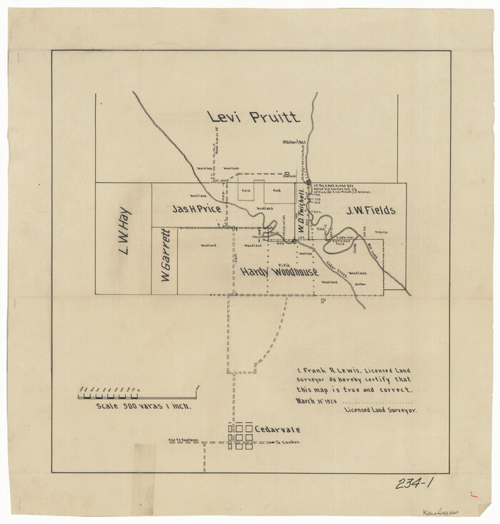
[Sketch of area just south of Levi Pruitt survey]
Print $20.00
- Digital $50.00
[Sketch of area just south of Levi Pruitt survey]
1924
Size: 17.0 x 17.8 inches
91855
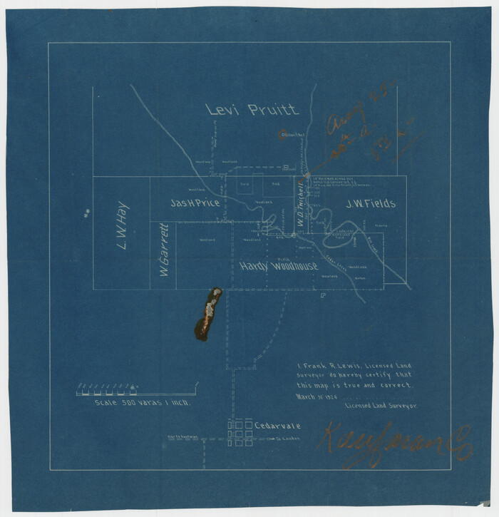
[Surveys South of Levi Pruitt]
Print $3.00
- Digital $50.00
[Surveys South of Levi Pruitt]
1924
Size: 11.3 x 11.6 inches
92092
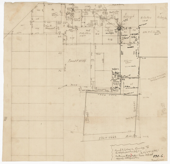
[Pencil sketch in vicinity of H. G. Sims, David F. Weff, B. Allen surveys]
Print $20.00
- Digital $50.00
[Pencil sketch in vicinity of H. G. Sims, David F. Weff, B. Allen surveys]
1924
Size: 18.9 x 18.2 inches
91853
Trinity River, Levee Improvement Districts, Widths of Floodways

Print $20.00
- Digital $50.00
Trinity River, Levee Improvement Districts, Widths of Floodways
1923
Size: 37.6 x 28.2 inches
65253
Kaufman County Sketch File 19

Print $30.00
- Digital $50.00
Kaufman County Sketch File 19
1922
Size: 11.2 x 8.7 inches
28666
Kaufman County State Real Property Sketch 2
Print $20.00
- Digital $50.00
Kaufman County State Real Property Sketch 2
2007
-
Size
24.2 x 35.4 inches
-
Map/Doc
88672
-
Creation Date
2007
Kaufman County State Real Property Sketch 1
Print $92.00
- Digital $50.00
Kaufman County State Real Property Sketch 1
2006
-
Size
24.6 x 35.4 inches
-
Map/Doc
88624
-
Creation Date
2006
Kaufman County Working Sketch 9
Print $20.00
- Digital $50.00
Kaufman County Working Sketch 9
1988
-
Size
35.9 x 29.8 inches
-
Map/Doc
66672
-
Creation Date
1988
Kaufman County Working Sketch 8
Print $20.00
- Digital $50.00
Kaufman County Working Sketch 8
1987
-
Size
35.7 x 42.3 inches
-
Map/Doc
66671
-
Creation Date
1987
Henderson County Working Sketch 41
Print $20.00
- Digital $50.00
Henderson County Working Sketch 41
1985
-
Size
28.8 x 17.0 inches
-
Map/Doc
66174
-
Creation Date
1985
Kaufman County Working Sketch 7
Print $20.00
- Digital $50.00
Kaufman County Working Sketch 7
1984
-
Size
33.6 x 35.5 inches
-
Map/Doc
66670
-
Creation Date
1984
General Highway Map, Kaufman County, Texas
Print $20.00
General Highway Map, Kaufman County, Texas
1961
-
Size
24.9 x 18.1 inches
-
Map/Doc
79548
-
Creation Date
1961
Kaufman County Rolled Sketch 1
Print $20.00
- Digital $50.00
Kaufman County Rolled Sketch 1
1951
-
Size
26.4 x 34.8 inches
-
Map/Doc
6456
-
Creation Date
1951
Kaufman County Sketch File 20
Print $20.00
- Digital $50.00
Kaufman County Sketch File 20
1950
-
Size
23.2 x 34.8 inches
-
Map/Doc
11908
-
Creation Date
1950
Kaufman County

Print $20.00
- Digital $50.00
Kaufman County
1942
-
Size
46.6 x 38.2 inches
-
Map/Doc
1871
-
Creation Date
1942
Kaufman County

Print $20.00
- Digital $50.00
Kaufman County
1942
-
Size
44.5 x 36.7 inches
-
Map/Doc
77335
-
Creation Date
1942
Kaufman County

Print $40.00
- Digital $50.00
Kaufman County
1942
-
Size
50.0 x 41.0 inches
-
Map/Doc
95552
-
Creation Date
1942
Kaufman County

Print $40.00
- Digital $50.00
Kaufman County
1942
-
Size
48.7 x 39.5 inches
-
Map/Doc
73202
-
Creation Date
1942
Kaufman County Working Sketch Graphic Index
Print $20.00
- Digital $50.00
Kaufman County Working Sketch Graphic Index
1942
-
Size
46.1 x 38.3 inches
-
Map/Doc
76601
-
Creation Date
1942
General Highway Map, Kaufman County, Texas
Print $20.00
General Highway Map, Kaufman County, Texas
1939
-
Size
24.8 x 18.3 inches
-
Map/Doc
79152
-
Creation Date
1939
Kaufman County Working Sketch 6
Print $20.00
- Digital $50.00
Kaufman County Working Sketch 6
1937
-
Size
22.4 x 27.9 inches
-
Map/Doc
66669
-
Creation Date
1937
Kaufman County Sketch File 18
Print $10.00
- Digital $50.00
Kaufman County Sketch File 18
1936
-
Size
11.4 x 8.8 inches
-
Map/Doc
28661
-
Creation Date
1936
Trinity River, Barnes Bridge Sheet/East Fork of Trinity River
Print $4.00
- Digital $50.00
Trinity River, Barnes Bridge Sheet/East Fork of Trinity River
1936
-
Size
29.5 x 22.7 inches
-
Map/Doc
65192
-
Creation Date
1936
Trinity River, Kaufman Sheet/Kings Creek
Print $6.00
- Digital $50.00
Trinity River, Kaufman Sheet/Kings Creek
1930
-
Size
32.6 x 27.0 inches
-
Map/Doc
65228
-
Creation Date
1930
Trinity River, Terrell Sheet/Kings Creek
Print $20.00
- Digital $50.00
Trinity River, Terrell Sheet/Kings Creek
1930
-
Size
42.3 x 19.7 inches
-
Map/Doc
65229
-
Creation Date
1930
Trinity River, Potter Bridge Sheet/Kings Creek
Print $20.00
- Digital $50.00
Trinity River, Potter Bridge Sheet/Kings Creek
1928
-
Size
42.1 x 34.0 inches
-
Map/Doc
65220
-
Creation Date
1928
Trinity River, Barnett Crossing Sheet/Brushy and Kings Creek
Print $20.00
- Digital $50.00
Trinity River, Barnett Crossing Sheet/Brushy and Kings Creek
1927
-
Size
41.3 x 30.2 inches
-
Map/Doc
65221
-
Creation Date
1927
Trinity River, Talty Sheet/Big Brushy Creek
Print $20.00
- Digital $50.00
Trinity River, Talty Sheet/Big Brushy Creek
1927
-
Size
42.2 x 20.3 inches
-
Map/Doc
65222
-
Creation Date
1927
Trinity River, Red Bank Sheet
Print $20.00
- Digital $50.00
Trinity River, Red Bank Sheet
1925
-
Size
16.4 x 24.4 inches
-
Map/Doc
69687
-
Creation Date
1925
Trinity River, Club House Sheet
Print $20.00
- Digital $50.00
Trinity River, Club House Sheet
1925
-
Size
27.7 x 23.7 inches
-
Map/Doc
69688
-
Creation Date
1925
[Sketch of area just south of Levi Pruitt survey]
Print $20.00
- Digital $50.00
[Sketch of area just south of Levi Pruitt survey]
1924
-
Size
17.0 x 17.8 inches
-
Map/Doc
91855
-
Creation Date
1924
[Surveys South of Levi Pruitt]
Print $3.00
- Digital $50.00
[Surveys South of Levi Pruitt]
1924
-
Size
11.3 x 11.6 inches
-
Map/Doc
92092
-
Creation Date
1924
[Pencil sketch in vicinity of H. G. Sims, David F. Weff, B. Allen surveys]
Print $20.00
- Digital $50.00
[Pencil sketch in vicinity of H. G. Sims, David F. Weff, B. Allen surveys]
1924
-
Size
18.9 x 18.2 inches
-
Map/Doc
91853
-
Creation Date
1924
Trinity River, Levee Improvement Districts, Widths of Floodways
Print $20.00
- Digital $50.00
Trinity River, Levee Improvement Districts, Widths of Floodways
1923
-
Size
37.6 x 28.2 inches
-
Map/Doc
65253
-
Creation Date
1923
Kaufman County Sketch File 19
Print $30.00
- Digital $50.00
Kaufman County Sketch File 19
1922
-
Size
11.2 x 8.7 inches
-
Map/Doc
28666
-
Creation Date
1922