Lynn County Rolled Sketch 17

Print $20.00
- Digital $50.00
Lynn County Rolled Sketch 17
1994
Size: 45.2 x 35.8 inches
9475
Lynn County Sketch File 22

Print $2.00
- Digital $50.00
Lynn County Sketch File 22
1994
Size: 11.1 x 8.8 inches
30553
Lynn County Rolled Sketch 16

Print $20.00
- Digital $50.00
Lynn County Rolled Sketch 16
1991
Size: 18.3 x 42.3 inches
6652
Lynn County Rolled Sketch 15

Print $20.00
- Digital $50.00
Lynn County Rolled Sketch 15
1986
Size: 36.4 x 24.5 inches
6651
Lynn County Working Sketch 5

Print $20.00
- Digital $50.00
Lynn County Working Sketch 5
1982
Size: 22.5 x 28.2 inches
70675
Lynn County Working Sketch 4

Print $20.00
- Digital $50.00
Lynn County Working Sketch 4
1965
Size: 33.5 x 33.8 inches
70674
Dawson County Working Sketch 18

Print $40.00
- Digital $50.00
Dawson County Working Sketch 18
1963
Size: 41.2 x 58.3 inches
68562
Sketch showing county lines of Lynn, Garza, Borden, Scurry

Print $40.00
- Digital $50.00
Sketch showing county lines of Lynn, Garza, Borden, Scurry
1961
Size: 23.9 x 79.9 inches
1719
Lynn County Working Sketch Graphic Index

Print $20.00
- Digital $50.00
Lynn County Working Sketch Graphic Index
1961
Size: 38.7 x 35.1 inches
76627
General Highway Map, Lynn County, Texas

Print $20.00
General Highway Map, Lynn County, Texas
1961
Size: 18.1 x 24.6 inches
79580
Lynn County Rolled Sketch 12

Print $20.00
- Digital $50.00
Lynn County Rolled Sketch 12
1956
Size: 35.0 x 24.5 inches
6648
[SW Corner of Lynn County]
Print $20.00
- Digital $50.00
[SW Corner of Lynn County]
1954
Size: 32.2 x 31.1 inches
92903
Lynn County Working Sketch 3

Print $20.00
- Digital $50.00
Lynn County Working Sketch 3
1953
Size: 30.8 x 30.9 inches
70673
Lynn County Rolled Sketch 14

Print $20.00
- Digital $50.00
Lynn County Rolled Sketch 14
1952
Size: 35.4 x 35.3 inches
9474
Nora Jane Wilson Lease

Print $20.00
- Digital $50.00
Nora Jane Wilson Lease
1952
Size: 12.5 x 15.0 inches
92962
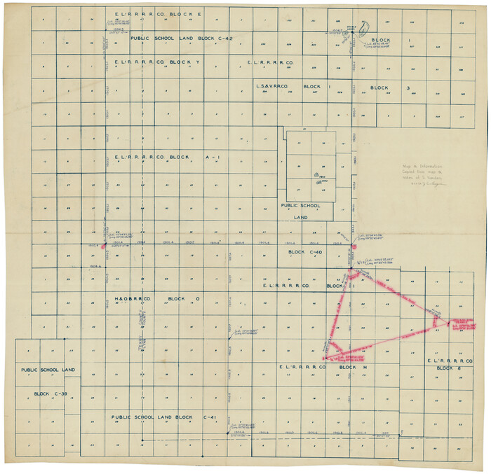
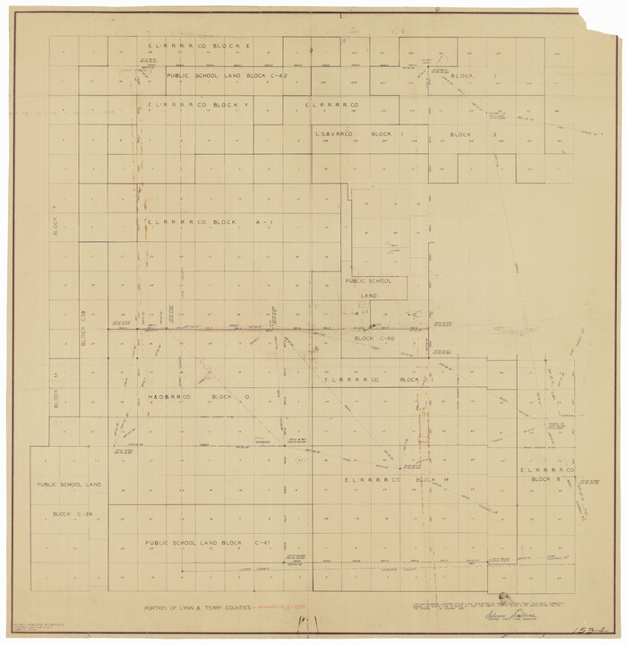
[Southwest Portion of Lynn County, Southeast Portion of Terry County]
Print $20.00
- Digital $50.00
[Southwest Portion of Lynn County, Southeast Portion of Terry County]
1952
Size: 34.3 x 35.1 inches
91305
Dawson County Sketch File 19

Print $20.00
- Digital $50.00
Dawson County Sketch File 19
1951
Size: 18.5 x 24.7 inches
11295
Lynn County Working Sketch 2

Print $20.00
- Digital $50.00
Lynn County Working Sketch 2
1951
Size: 19.8 x 42.5 inches
70672
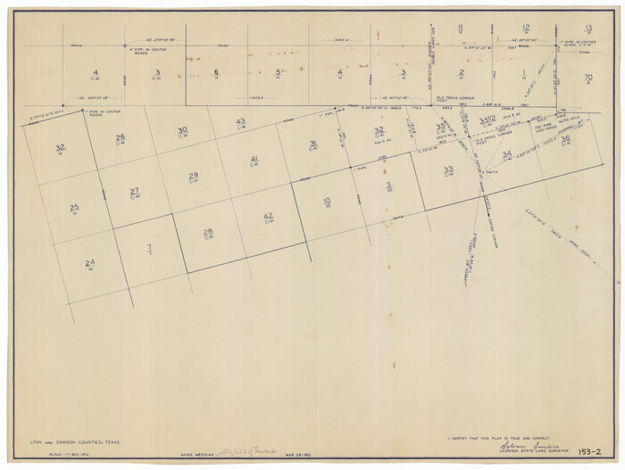
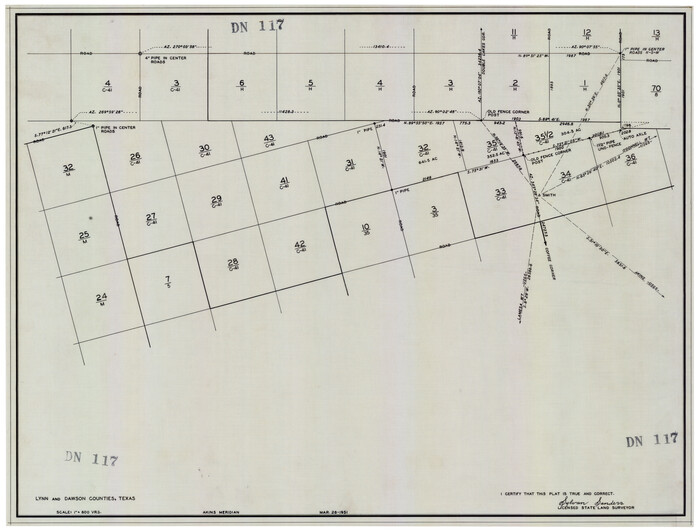
[Block H, E. L. & R. R. Block C-41, and Public School Lands]
Print $20.00
- Digital $50.00
[Block H, E. L. & R. R. Block C-41, and Public School Lands]
1951
Size: 24.5 x 18.4 inches
91386
[Blocks H and C41]
Print $20.00
- Digital $50.00
[Blocks H and C41]
1951
Size: 24.6 x 18.8 inches
92623
Map of Public Roads in Terry County, Texas

Print $2.00
- Digital $50.00
Map of Public Roads in Terry County, Texas
1951
Size: 9.1 x 11.6 inches
91937
General Highway Map Lynn County

Print $20.00
- Digital $50.00
General Highway Map Lynn County
1949
Size: 25.8 x 18.8 inches
92901
Terry County Sketch File 3

Print $20.00
- Digital $50.00
Terry County Sketch File 3
1948
Size: 16.2 x 39.0 inches
10390
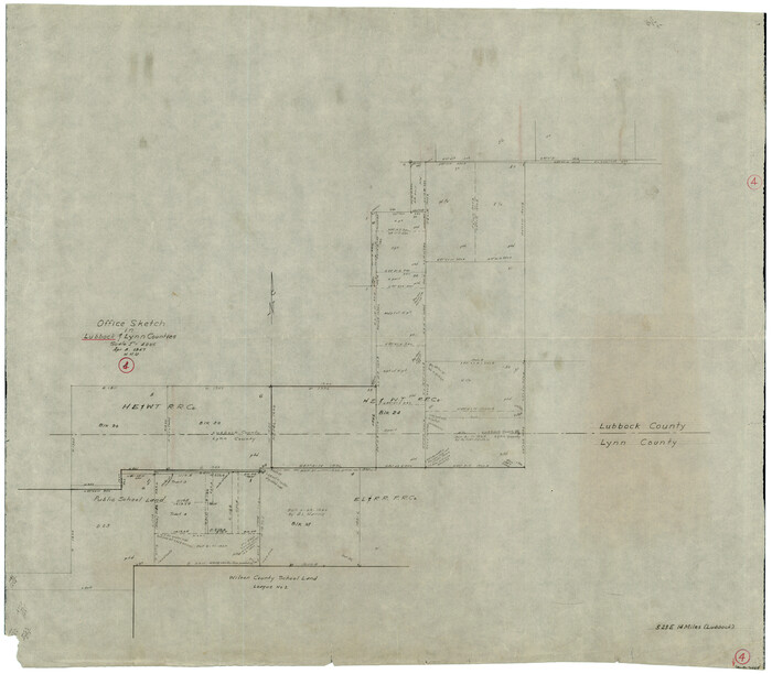
Lubbock County Working Sketch 4
Print $20.00
- Digital $50.00
Lubbock County Working Sketch 4
1947
Size: 31.8 x 36.8 inches
70664
Texas Coordinate File 6

Print $40.00
- Digital $50.00
Texas Coordinate File 6
1946
Size: 23.7 x 49.0 inches
75314
Plat Compiled by W.J. Williams, Plainview, Texas, and Sylvan Sanders, Lubbock, Texas Showing Position of Original and Re-Survey Corners in Lynn, Terry, Yoakum, Gaines, and Dawson Counties, Texas

Print $40.00
- Digital $50.00
Plat Compiled by W.J. Williams, Plainview, Texas, and Sylvan Sanders, Lubbock, Texas Showing Position of Original and Re-Survey Corners in Lynn, Terry, Yoakum, Gaines, and Dawson Counties, Texas
1946
Size: 56.6 x 22.6 inches
89628
Showing Position of Original and Re-Survey Corners in Lynn, Terry, Yoakum, Gaines and Dawson Counties, Texas

Print $40.00
- Digital $50.00
Showing Position of Original and Re-Survey Corners in Lynn, Terry, Yoakum, Gaines and Dawson Counties, Texas
1946
Size: 57.3 x 22.1 inches
93044
Lynn County Rolled Sketch 17
Print $20.00
- Digital $50.00
Lynn County Rolled Sketch 17
1994
-
Size
45.2 x 35.8 inches
-
Map/Doc
9475
-
Creation Date
1994
Lynn County Sketch File 22
Print $2.00
- Digital $50.00
Lynn County Sketch File 22
1994
-
Size
11.1 x 8.8 inches
-
Map/Doc
30553
-
Creation Date
1994
Lynn County Rolled Sketch 16
Print $20.00
- Digital $50.00
Lynn County Rolled Sketch 16
1991
-
Size
18.3 x 42.3 inches
-
Map/Doc
6652
-
Creation Date
1991
Lynn County Rolled Sketch 15
Print $20.00
- Digital $50.00
Lynn County Rolled Sketch 15
1986
-
Size
36.4 x 24.5 inches
-
Map/Doc
6651
-
Creation Date
1986
Lynn County Working Sketch 5
Print $20.00
- Digital $50.00
Lynn County Working Sketch 5
1982
-
Size
22.5 x 28.2 inches
-
Map/Doc
70675
-
Creation Date
1982
Lynn County Working Sketch 4
Print $20.00
- Digital $50.00
Lynn County Working Sketch 4
1965
-
Size
33.5 x 33.8 inches
-
Map/Doc
70674
-
Creation Date
1965
Dawson County Working Sketch 18
Print $40.00
- Digital $50.00
Dawson County Working Sketch 18
1963
-
Size
41.2 x 58.3 inches
-
Map/Doc
68562
-
Creation Date
1963
Lynn County

Print $20.00
- Digital $50.00
Lynn County
1961
-
Size
40.3 x 36.5 inches
-
Map/Doc
73227
-
Creation Date
1961
Lynn County

Print $20.00
- Digital $50.00
Lynn County
1961
-
Size
39.2 x 35.7 inches
-
Map/Doc
77360
-
Creation Date
1961
Lynn County

Print $20.00
- Digital $50.00
Lynn County
1961
-
Size
41.3 x 37.5 inches
-
Map/Doc
95577
-
Creation Date
1961
Sketch showing county lines of Lynn, Garza, Borden, Scurry
Print $40.00
- Digital $50.00
Sketch showing county lines of Lynn, Garza, Borden, Scurry
1961
-
Size
23.9 x 79.9 inches
-
Map/Doc
1719
-
Creation Date
1961
Lynn County Working Sketch Graphic Index
Print $20.00
- Digital $50.00
Lynn County Working Sketch Graphic Index
1961
-
Size
38.7 x 35.1 inches
-
Map/Doc
76627
-
Creation Date
1961
General Highway Map, Lynn County, Texas
Print $20.00
General Highway Map, Lynn County, Texas
1961
-
Size
18.1 x 24.6 inches
-
Map/Doc
79580
-
Creation Date
1961
Lynn County Rolled Sketch 12
Print $20.00
- Digital $50.00
Lynn County Rolled Sketch 12
1956
-
Size
35.0 x 24.5 inches
-
Map/Doc
6648
-
Creation Date
1956
[SW Corner of Lynn County]
Print $20.00
- Digital $50.00
[SW Corner of Lynn County]
1954
-
Size
32.2 x 31.1 inches
-
Map/Doc
92903
-
Creation Date
1954
Lynn County Working Sketch 3
Print $20.00
- Digital $50.00
Lynn County Working Sketch 3
1953
-
Size
30.8 x 30.9 inches
-
Map/Doc
70673
-
Creation Date
1953
Lynn County Rolled Sketch 14
Print $20.00
- Digital $50.00
Lynn County Rolled Sketch 14
1952
-
Size
35.4 x 35.3 inches
-
Map/Doc
9474
-
Creation Date
1952
Nora Jane Wilson Lease
Print $20.00
- Digital $50.00
Nora Jane Wilson Lease
1952
-
Size
12.5 x 15.0 inches
-
Map/Doc
92962
-
Creation Date
1952
[Southwest Portion of Lynn County, Southeast Portion of Terry County]
Print $20.00
- Digital $50.00
[Southwest Portion of Lynn County, Southeast Portion of Terry County]
1952
-
Size
34.3 x 35.1 inches
-
Map/Doc
91305
-
Creation Date
1952
Dawson County Sketch File 19
Print $20.00
- Digital $50.00
Dawson County Sketch File 19
1951
-
Size
18.5 x 24.7 inches
-
Map/Doc
11295
-
Creation Date
1951
Lynn County Working Sketch 2
Print $20.00
- Digital $50.00
Lynn County Working Sketch 2
1951
-
Size
19.8 x 42.5 inches
-
Map/Doc
70672
-
Creation Date
1951
[Block H, E. L. & R. R. Block C-41, and Public School Lands]
Print $20.00
- Digital $50.00
[Block H, E. L. & R. R. Block C-41, and Public School Lands]
1951
-
Size
24.5 x 18.4 inches
-
Map/Doc
91386
-
Creation Date
1951
[Blocks H and C41]
Print $20.00
- Digital $50.00
[Blocks H and C41]
1951
-
Size
24.6 x 18.8 inches
-
Map/Doc
92623
-
Creation Date
1951
Map of Public Roads in Terry County, Texas
Print $2.00
- Digital $50.00
Map of Public Roads in Terry County, Texas
1951
-
Size
9.1 x 11.6 inches
-
Map/Doc
91937
-
Creation Date
1951
General Highway Map Lynn County
Print $20.00
- Digital $50.00
General Highway Map Lynn County
1949
-
Size
25.8 x 18.8 inches
-
Map/Doc
92901
-
Creation Date
1949
Terry County Sketch File 3
Print $20.00
- Digital $50.00
Terry County Sketch File 3
1948
-
Size
16.2 x 39.0 inches
-
Map/Doc
10390
-
Creation Date
1948
Lubbock County Working Sketch 4
Print $20.00
- Digital $50.00
Lubbock County Working Sketch 4
1947
-
Size
31.8 x 36.8 inches
-
Map/Doc
70664
-
Creation Date
1947
Texas Coordinate File 6
Print $40.00
- Digital $50.00
Texas Coordinate File 6
1946
-
Size
23.7 x 49.0 inches
-
Map/Doc
75314
-
Creation Date
1946
Plat Compiled by W.J. Williams, Plainview, Texas, and Sylvan Sanders, Lubbock, Texas Showing Position of Original and Re-Survey Corners in Lynn, Terry, Yoakum, Gaines, and Dawson Counties, Texas
Print $40.00
- Digital $50.00
Plat Compiled by W.J. Williams, Plainview, Texas, and Sylvan Sanders, Lubbock, Texas Showing Position of Original and Re-Survey Corners in Lynn, Terry, Yoakum, Gaines, and Dawson Counties, Texas
1946
-
Size
56.6 x 22.6 inches
-
Map/Doc
89628
-
Creation Date
1946
Showing Position of Original and Re-Survey Corners in Lynn, Terry, Yoakum, Gaines and Dawson Counties, Texas
Print $40.00
- Digital $50.00
Showing Position of Original and Re-Survey Corners in Lynn, Terry, Yoakum, Gaines and Dawson Counties, Texas
1946
-
Size
57.3 x 22.1 inches
-
Map/Doc
93044
-
Creation Date
1946