[Marion County, Texas]
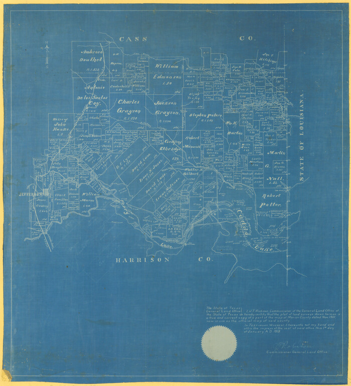
Print $20.00
- Digital $50.00
[Marion County, Texas]
1901
Size: 26.5 x 24.1 inches
75777
[Map representing Townships 21, 20 and part of 19 of Range 17 and the corresponding ones in the 16th Range, according to the United States surveys showing the Boundary between the Republic of Texas and the United States of America]
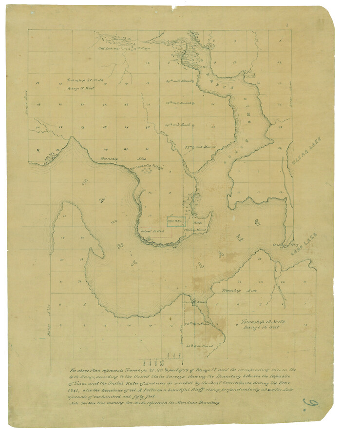
Print $20.00
- Digital $50.00
[Map representing Townships 21, 20 and part of 19 of Range 17 and the corresponding ones in the 16th Range, according to the United States surveys showing the Boundary between the Republic of Texas and the United States of America]
1841
Size: 19.5 x 15.4 inches
262
[East Line & Red River Railroad from Sulphur Springs to Jefferson]
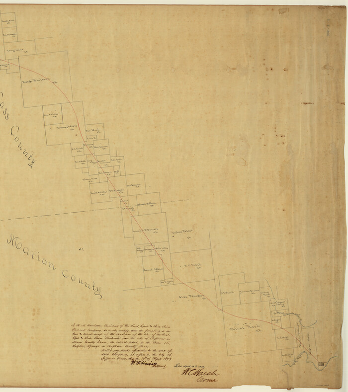
Print $20.00
- Digital $50.00
[East Line & Red River Railroad from Sulphur Springs to Jefferson]
1879
Size: 37.8 x 33.6 inches
64769
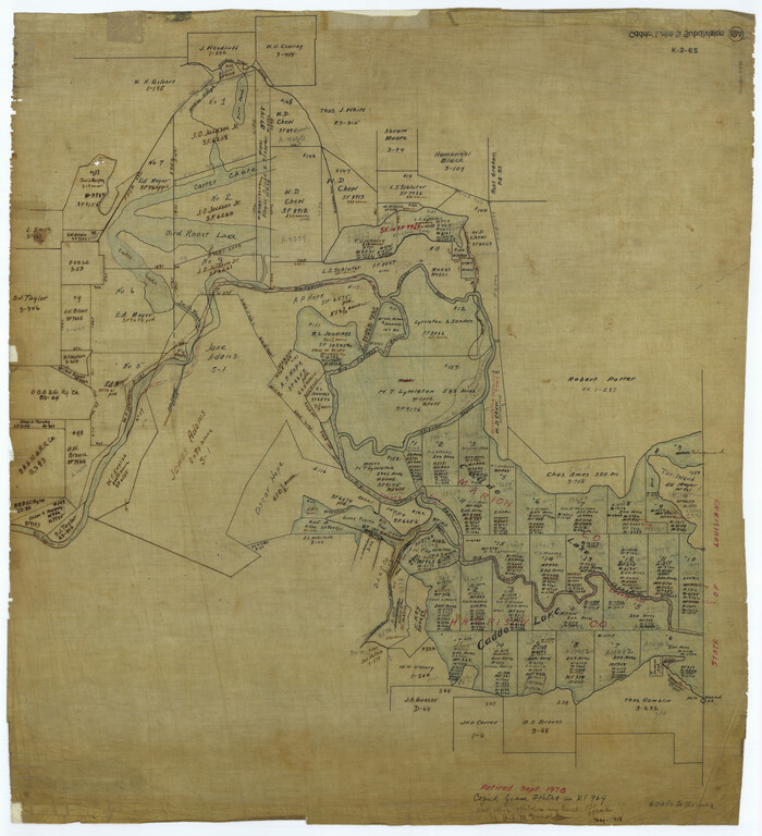
[Caddo Lake Area]
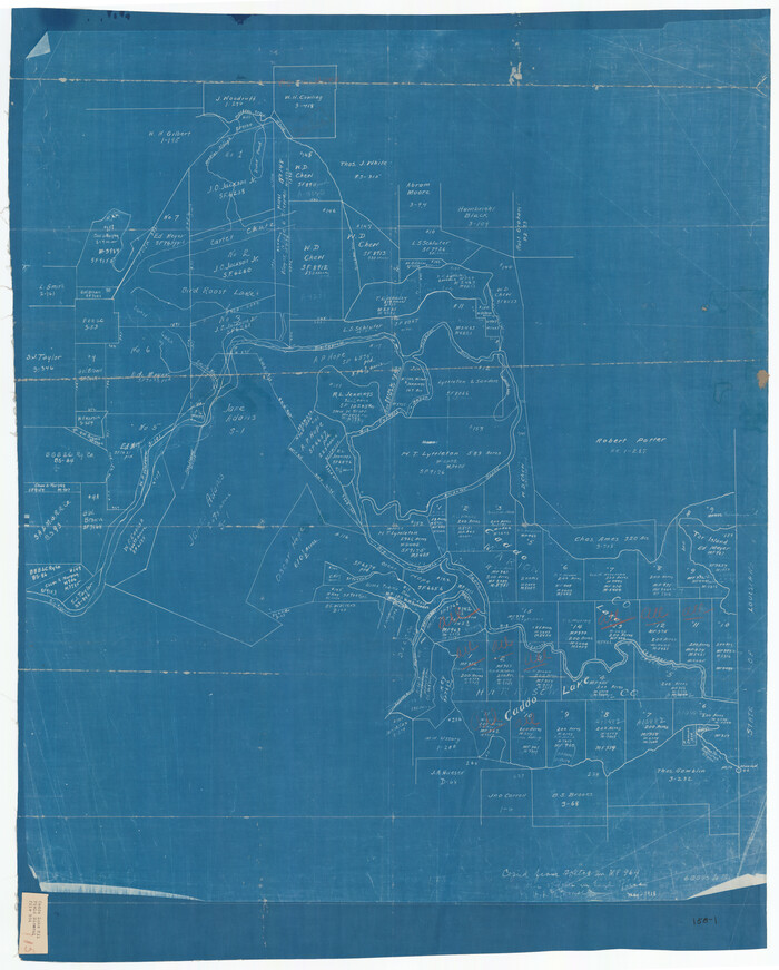
Print $20.00
- Digital $50.00
[Caddo Lake Area]
1918
Size: 28.4 x 35.3 inches
91389
[Caddo Lake & Subdivisions]
Print $20.00
- Digital $50.00
[Caddo Lake & Subdivisions]
1918
Size: 31.3 x 28.6 inches
2896
Sketch of surveys in Harrison & Marion Cos. showing Caddo Lake & Subdivisions

Print $5.00
- Digital $50.00
Sketch of surveys in Harrison & Marion Cos. showing Caddo Lake & Subdivisions
1955
Size: 32.6 x 32.5 inches
2895
Sketch of surveys in Harrison & Marion Cos. Showing Caddo Lake & Subdivisions

Print $20.00
- Digital $50.00
Sketch of surveys in Harrison & Marion Cos. Showing Caddo Lake & Subdivisions
1955
Size: 32.7 x 33.1 inches
1928
Sketch of surveys in Harrison & Marion Cos. Showing Caddo Lake & Subdivisions

Print $20.00
- Digital $50.00
Sketch of surveys in Harrison & Marion Cos. Showing Caddo Lake & Subdivisions
1955
Size: 33.8 x 32.4 inches
93284
Morris County Sketch File 1

Print $4.00
- Digital $50.00
Morris County Sketch File 1
Size: 12.4 x 6.5 inches
31963
Morris County Rolled Sketch 2A

Print $20.00
- Digital $50.00
Morris County Rolled Sketch 2A
Size: 36.2 x 19.3 inches
10282
Morris County Rolled Sketch 2

Print $40.00
- Digital $50.00
Morris County Rolled Sketch 2
1944
Size: 59.4 x 43.5 inches
9550
Marion County, Texas

Print $20.00
- Digital $50.00
Marion County, Texas
1879
Size: 15.0 x 20.7 inches
651
Marion County Working Sketch Graphic Index, Sheet 2 (Sketches 27 to Most Recent)

Print $20.00
- Digital $50.00
Marion County Working Sketch Graphic Index, Sheet 2 (Sketches 27 to Most Recent)
1943
Size: 26.5 x 44.9 inches
76630
Marion County Working Sketch Graphic Index, Sheet 1 (Sketches 1 to 26)

Print $20.00
- Digital $50.00
Marion County Working Sketch Graphic Index, Sheet 1 (Sketches 1 to 26)
1943
Size: 26.8 x 45.1 inches
76629
Marion County Working Sketch 9

Print $20.00
- Digital $50.00
Marion County Working Sketch 9
1940
Size: 23.5 x 25.5 inches
70784
Marion County Working Sketch 8

Print $20.00
- Digital $50.00
Marion County Working Sketch 8
1935
Size: 31.9 x 36.6 inches
70783
Marion County Working Sketch 7

Print $20.00
- Digital $50.00
Marion County Working Sketch 7
1918
Size: 27.9 x 27.7 inches
70782
Marion County Working Sketch 6

Print $20.00
- Digital $50.00
Marion County Working Sketch 6
1962
Size: 33.7 x 19.8 inches
70781
Marion County Working Sketch 5

Print $20.00
- Digital $50.00
Marion County Working Sketch 5
1910
Size: 24.5 x 15.2 inches
70780
Marion County Working Sketch 46

Print $20.00
- Digital $50.00
Marion County Working Sketch 46
2011
Size: 21.4 x 29.1 inches
90032
Marion County Working Sketch 45

Print $20.00
- Digital $50.00
Marion County Working Sketch 45
2005
Size: 27.0 x 29.2 inches
83576
Marion County Working Sketch 44

Print $20.00
- Digital $50.00
Marion County Working Sketch 44
2002
Size: 42.7 x 27.0 inches
78215
Marion County Working Sketch 43

Print $20.00
- Digital $50.00
Marion County Working Sketch 43
2002
Size: 28.6 x 29.0 inches
78214
Marion County Working Sketch 42

Print $20.00
- Digital $50.00
Marion County Working Sketch 42
2000
Size: 29.6 x 41.4 inches
70818
Marion County Working Sketch 41

Print $40.00
- Digital $50.00
Marion County Working Sketch 41
1996
Size: 34.0 x 48.5 inches
70817
Marion County Working Sketch 40

Print $20.00
- Digital $50.00
Marion County Working Sketch 40
1992
Size: 42.9 x 30.0 inches
70816
Marion County Working Sketch 4

Print $20.00
- Digital $50.00
Marion County Working Sketch 4
Size: 15.7 x 19.1 inches
70779
Marion County Working Sketch 39

Print $20.00
- Digital $50.00
Marion County Working Sketch 39
1991
Size: 20.8 x 19.2 inches
70815
[Marion County, Texas]
Print $20.00
- Digital $50.00
[Marion County, Texas]
1901
-
Size
26.5 x 24.1 inches
-
Map/Doc
75777
-
Creation Date
1901
[Map representing Townships 21, 20 and part of 19 of Range 17 and the corresponding ones in the 16th Range, according to the United States surveys showing the Boundary between the Republic of Texas and the United States of America]
Print $20.00
- Digital $50.00
[Map representing Townships 21, 20 and part of 19 of Range 17 and the corresponding ones in the 16th Range, according to the United States surveys showing the Boundary between the Republic of Texas and the United States of America]
1841
-
Size
19.5 x 15.4 inches
-
Map/Doc
262
-
Creation Date
1841
[East Line & Red River Railroad from Sulphur Springs to Jefferson]
Print $20.00
- Digital $50.00
[East Line & Red River Railroad from Sulphur Springs to Jefferson]
1879
-
Size
37.8 x 33.6 inches
-
Map/Doc
64769
-
Creation Date
1879
[Caddo Lake Area]
Print $20.00
- Digital $50.00
[Caddo Lake Area]
1918
-
Size
28.4 x 35.3 inches
-
Map/Doc
91389
-
Creation Date
1918
[Caddo Lake & Subdivisions]
Print $20.00
- Digital $50.00
[Caddo Lake & Subdivisions]
1918
-
Size
31.3 x 28.6 inches
-
Map/Doc
2896
-
Creation Date
1918
Titus County

Print $20.00
- Digital $50.00
Titus County
1858
-
Size
27.9 x 38.1 inches
-
Map/Doc
16897
-
Creation Date
1858
Sketch of surveys in Harrison & Marion Cos. showing Caddo Lake & Subdivisions
Print $5.00
- Digital $50.00
Sketch of surveys in Harrison & Marion Cos. showing Caddo Lake & Subdivisions
1955
-
Size
32.6 x 32.5 inches
-
Map/Doc
2895
-
Creation Date
1955
Sketch of surveys in Harrison & Marion Cos. Showing Caddo Lake & Subdivisions
Print $20.00
- Digital $50.00
Sketch of surveys in Harrison & Marion Cos. Showing Caddo Lake & Subdivisions
1955
-
Size
32.7 x 33.1 inches
-
Map/Doc
1928
-
Creation Date
1955
Sketch of surveys in Harrison & Marion Cos. Showing Caddo Lake & Subdivisions
Print $20.00
- Digital $50.00
Sketch of surveys in Harrison & Marion Cos. Showing Caddo Lake & Subdivisions
1955
-
Size
33.8 x 32.4 inches
-
Map/Doc
93284
-
Creation Date
1955
Morris County Sketch File 1
Print $4.00
- Digital $50.00
Morris County Sketch File 1
-
Size
12.4 x 6.5 inches
-
Map/Doc
31963
Morris County Rolled Sketch 2A
Print $20.00
- Digital $50.00
Morris County Rolled Sketch 2A
-
Size
36.2 x 19.3 inches
-
Map/Doc
10282
Morris County Rolled Sketch 2
Print $40.00
- Digital $50.00
Morris County Rolled Sketch 2
1944
-
Size
59.4 x 43.5 inches
-
Map/Doc
9550
-
Creation Date
1944
Marion County, Texas
Print $20.00
- Digital $50.00
Marion County, Texas
1879
-
Size
15.0 x 20.7 inches
-
Map/Doc
651
-
Creation Date
1879
Marion County, Texas

Print $20.00
Marion County, Texas
1879
-
Size
14.2 x 20.4 inches
-
Map/Doc
88976
-
Creation Date
1879
Marion County Working Sketch Graphic Index, Sheet 2 (Sketches 27 to Most Recent)
Print $20.00
- Digital $50.00
Marion County Working Sketch Graphic Index, Sheet 2 (Sketches 27 to Most Recent)
1943
-
Size
26.5 x 44.9 inches
-
Map/Doc
76630
-
Creation Date
1943
Marion County Working Sketch Graphic Index, Sheet 1 (Sketches 1 to 26)
Print $20.00
- Digital $50.00
Marion County Working Sketch Graphic Index, Sheet 1 (Sketches 1 to 26)
1943
-
Size
26.8 x 45.1 inches
-
Map/Doc
76629
-
Creation Date
1943
Marion County Working Sketch 9
Print $20.00
- Digital $50.00
Marion County Working Sketch 9
1940
-
Size
23.5 x 25.5 inches
-
Map/Doc
70784
-
Creation Date
1940
Marion County Working Sketch 8
Print $20.00
- Digital $50.00
Marion County Working Sketch 8
1935
-
Size
31.9 x 36.6 inches
-
Map/Doc
70783
-
Creation Date
1935
Marion County Working Sketch 7
Print $20.00
- Digital $50.00
Marion County Working Sketch 7
1918
-
Size
27.9 x 27.7 inches
-
Map/Doc
70782
-
Creation Date
1918
Marion County Working Sketch 6
Print $20.00
- Digital $50.00
Marion County Working Sketch 6
1962
-
Size
33.7 x 19.8 inches
-
Map/Doc
70781
-
Creation Date
1962
Marion County Working Sketch 5
Print $20.00
- Digital $50.00
Marion County Working Sketch 5
1910
-
Size
24.5 x 15.2 inches
-
Map/Doc
70780
-
Creation Date
1910
Marion County Working Sketch 46
Print $20.00
- Digital $50.00
Marion County Working Sketch 46
2011
-
Size
21.4 x 29.1 inches
-
Map/Doc
90032
-
Creation Date
2011
Marion County Working Sketch 45
Print $20.00
- Digital $50.00
Marion County Working Sketch 45
2005
-
Size
27.0 x 29.2 inches
-
Map/Doc
83576
-
Creation Date
2005
Marion County Working Sketch 44
Print $20.00
- Digital $50.00
Marion County Working Sketch 44
2002
-
Size
42.7 x 27.0 inches
-
Map/Doc
78215
-
Creation Date
2002
Marion County Working Sketch 43
Print $20.00
- Digital $50.00
Marion County Working Sketch 43
2002
-
Size
28.6 x 29.0 inches
-
Map/Doc
78214
-
Creation Date
2002
Marion County Working Sketch 42
Print $20.00
- Digital $50.00
Marion County Working Sketch 42
2000
-
Size
29.6 x 41.4 inches
-
Map/Doc
70818
-
Creation Date
2000
Marion County Working Sketch 41
Print $40.00
- Digital $50.00
Marion County Working Sketch 41
1996
-
Size
34.0 x 48.5 inches
-
Map/Doc
70817
-
Creation Date
1996
Marion County Working Sketch 40
Print $20.00
- Digital $50.00
Marion County Working Sketch 40
1992
-
Size
42.9 x 30.0 inches
-
Map/Doc
70816
-
Creation Date
1992
Marion County Working Sketch 4
Print $20.00
- Digital $50.00
Marion County Working Sketch 4
-
Size
15.7 x 19.1 inches
-
Map/Doc
70779
Marion County Working Sketch 39
Print $20.00
- Digital $50.00
Marion County Working Sketch 39
1991
-
Size
20.8 x 19.2 inches
-
Map/Doc
70815
-
Creation Date
1991