Morris County Rolled Sketch 2A

Print $20.00
- Digital $50.00
Morris County Rolled Sketch 2A
Size: 36.2 x 19.3 inches
10282
Harrison County Sketch File 15

Print $20.00
- Digital $50.00
Harrison County Sketch File 15
Size: 23.2 x 23.0 inches
11690
Marion County Sketch File 14

Print $20.00
- Digital $50.00
Marion County Sketch File 14
Size: 26.6 x 17.1 inches
12024
Marion County Sketch File 17

Print $20.00
- Digital $50.00
Marion County Sketch File 17
Size: 32.7 x 19.0 inches
12026
Marion County Sketch File 1b

Print $8.00
- Digital $50.00
Marion County Sketch File 1b
Size: 12.4 x 7.7 inches
30560
Marion County Sketch File 6

Print $24.00
- Digital $50.00
Marion County Sketch File 6
Size: 9.3 x 7.2 inches
30570
Marion County Sketch File 9

Print $4.00
- Digital $50.00
Marion County Sketch File 9
Size: 9.4 x 7.8 inches
30577
Morris County Sketch File 1

Print $4.00
- Digital $50.00
Morris County Sketch File 1
Size: 12.4 x 6.5 inches
31963
Cass County Rolled Sketch 5A

Print $20.00
- Digital $50.00
Cass County Rolled Sketch 5A
Size: 15.4 x 18.0 inches
5411
Marion County Boundary File 61

Print $6.00
- Digital $50.00
Marion County Boundary File 61
Size: 12.8 x 8.2 inches
56816
Marion County Boundary File 2

Print $6.00
- Digital $50.00
Marion County Boundary File 2
Size: 11.2 x 8.7 inches
56818
Marion County Boundary File 1

Print $14.00
- Digital $50.00
Marion County Boundary File 1
Size: 12.9 x 8.2 inches
56822
Marion County Rolled Sketch 7

Print $20.00
- Digital $50.00
Marion County Rolled Sketch 7
Size: 13.1 x 30.9 inches
6660
Marion County Working Sketch 1

Print $20.00
- Digital $50.00
Marion County Working Sketch 1
Size: 15.2 x 23.3 inches
70776
Marion County Working Sketch 2

Print $20.00
- Digital $50.00
Marion County Working Sketch 2
Size: 37.5 x 28.2 inches
70777
Marion County Working Sketch 3

Print $20.00
- Digital $50.00
Marion County Working Sketch 3
Size: 34.9 x 30.0 inches
70778
Marion County Working Sketch 4

Print $20.00
- Digital $50.00
Marion County Working Sketch 4
Size: 15.7 x 19.1 inches
70779
Marion County Rolled Sketch JB

Print $40.00
- Digital $50.00
Marion County Rolled Sketch JB
Size: 51.9 x 23.1 inches
9488
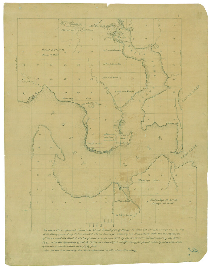
[Map representing Townships 21, 20 and part of 19 of Range 17 and the corresponding ones in the 16th Range, according to the United States surveys showing the Boundary between the Republic of Texas and the United States of America]
Print $20.00
- Digital $50.00
[Map representing Townships 21, 20 and part of 19 of Range 17 and the corresponding ones in the 16th Range, according to the United States surveys showing the Boundary between the Republic of Texas and the United States of America]
1841
Size: 19.5 x 15.4 inches
262
Map of Jefferson as owned by Allen Urquhart

Print $20.00
- Digital $50.00
Map of Jefferson as owned by Allen Urquhart
1850
Size: 25.1 x 16.6 inches
1684
Cass County Sketch File 5 1/2

Print $4.00
- Digital $50.00
Cass County Sketch File 5 1/2
1851
Size: 6.1 x 8.5 inches
17404
Marion County Sketch File 8

Print $4.00
- Digital $50.00
Marion County Sketch File 8
1852
Size: 10.0 x 8.1 inches
30575
Cass County Sketch File 6

Print $4.00
- Digital $50.00
Cass County Sketch File 6
1852
Size: 8.4 x 8.8 inches
17406
Marion County Sketch File 2

Print $4.00
- Digital $50.00
Marion County Sketch File 2
1853
Size: 8.3 x 14.2 inches
30564
Harrison County Sketch File 7

Print $6.00
- Digital $50.00
Harrison County Sketch File 7
1858
Size: 11.7 x 9.7 inches
26046
Marion County Sketch File 3

Print $8.00
- Digital $50.00
Marion County Sketch File 3
1860
Size: 14.1 x 8.8 inches
30566
Harrison County Sketch File 8

Print $20.00
- Digital $50.00
Harrison County Sketch File 8
1861
Size: 17.3 x 15.9 inches
11685
Harrison County Sketch File 9

Print $4.00
- Digital $50.00
Harrison County Sketch File 9
1862
Size: 8.3 x 11.1 inches
26048
Marion County Sketch File 7

Print $40.00
- Digital $50.00
Marion County Sketch File 7
1866
Size: 16.2 x 12.0 inches
30573
Morris County Rolled Sketch 2A
Print $20.00
- Digital $50.00
Morris County Rolled Sketch 2A
-
Size
36.2 x 19.3 inches
-
Map/Doc
10282
Harrison County Sketch File 15
Print $20.00
- Digital $50.00
Harrison County Sketch File 15
-
Size
23.2 x 23.0 inches
-
Map/Doc
11690
Marion County Sketch File 14
Print $20.00
- Digital $50.00
Marion County Sketch File 14
-
Size
26.6 x 17.1 inches
-
Map/Doc
12024
Marion County Sketch File 17
Print $20.00
- Digital $50.00
Marion County Sketch File 17
-
Size
32.7 x 19.0 inches
-
Map/Doc
12026
Marion County Sketch File 1b
Print $8.00
- Digital $50.00
Marion County Sketch File 1b
-
Size
12.4 x 7.7 inches
-
Map/Doc
30560
Marion County Sketch File 6
Print $24.00
- Digital $50.00
Marion County Sketch File 6
-
Size
9.3 x 7.2 inches
-
Map/Doc
30570
Marion County Sketch File 9
Print $4.00
- Digital $50.00
Marion County Sketch File 9
-
Size
9.4 x 7.8 inches
-
Map/Doc
30577
Morris County Sketch File 1
Print $4.00
- Digital $50.00
Morris County Sketch File 1
-
Size
12.4 x 6.5 inches
-
Map/Doc
31963
Cass County Rolled Sketch 5A
Print $20.00
- Digital $50.00
Cass County Rolled Sketch 5A
-
Size
15.4 x 18.0 inches
-
Map/Doc
5411
Marion County Boundary File 61
Print $6.00
- Digital $50.00
Marion County Boundary File 61
-
Size
12.8 x 8.2 inches
-
Map/Doc
56816
Marion County Boundary File 2
Print $6.00
- Digital $50.00
Marion County Boundary File 2
-
Size
11.2 x 8.7 inches
-
Map/Doc
56818
Marion County Boundary File 1
Print $14.00
- Digital $50.00
Marion County Boundary File 1
-
Size
12.9 x 8.2 inches
-
Map/Doc
56822
Marion County Rolled Sketch 7
Print $20.00
- Digital $50.00
Marion County Rolled Sketch 7
-
Size
13.1 x 30.9 inches
-
Map/Doc
6660
Marion County Working Sketch 1
Print $20.00
- Digital $50.00
Marion County Working Sketch 1
-
Size
15.2 x 23.3 inches
-
Map/Doc
70776
Marion County Working Sketch 2
Print $20.00
- Digital $50.00
Marion County Working Sketch 2
-
Size
37.5 x 28.2 inches
-
Map/Doc
70777
Marion County Working Sketch 3
Print $20.00
- Digital $50.00
Marion County Working Sketch 3
-
Size
34.9 x 30.0 inches
-
Map/Doc
70778
Marion County Working Sketch 4
Print $20.00
- Digital $50.00
Marion County Working Sketch 4
-
Size
15.7 x 19.1 inches
-
Map/Doc
70779
Marion County Rolled Sketch JB
Print $40.00
- Digital $50.00
Marion County Rolled Sketch JB
-
Size
51.9 x 23.1 inches
-
Map/Doc
9488
[Map representing Townships 21, 20 and part of 19 of Range 17 and the corresponding ones in the 16th Range, according to the United States surveys showing the Boundary between the Republic of Texas and the United States of America]
Print $20.00
- Digital $50.00
[Map representing Townships 21, 20 and part of 19 of Range 17 and the corresponding ones in the 16th Range, according to the United States surveys showing the Boundary between the Republic of Texas and the United States of America]
1841
-
Size
19.5 x 15.4 inches
-
Map/Doc
262
-
Creation Date
1841
Map of Jefferson as owned by Allen Urquhart
Print $20.00
- Digital $50.00
Map of Jefferson as owned by Allen Urquhart
1850
-
Size
25.1 x 16.6 inches
-
Map/Doc
1684
-
Creation Date
1850
Cass County Sketch File 5 1/2
Print $4.00
- Digital $50.00
Cass County Sketch File 5 1/2
1851
-
Size
6.1 x 8.5 inches
-
Map/Doc
17404
-
Creation Date
1851
Marion County Sketch File 8
Print $4.00
- Digital $50.00
Marion County Sketch File 8
1852
-
Size
10.0 x 8.1 inches
-
Map/Doc
30575
-
Creation Date
1852
Cass County Sketch File 6
Print $4.00
- Digital $50.00
Cass County Sketch File 6
1852
-
Size
8.4 x 8.8 inches
-
Map/Doc
17406
-
Creation Date
1852
Marion County Sketch File 2
Print $4.00
- Digital $50.00
Marion County Sketch File 2
1853
-
Size
8.3 x 14.2 inches
-
Map/Doc
30564
-
Creation Date
1853
Titus County

Print $20.00
- Digital $50.00
Titus County
1858
-
Size
27.9 x 38.1 inches
-
Map/Doc
16897
-
Creation Date
1858
Harrison County Sketch File 7
Print $6.00
- Digital $50.00
Harrison County Sketch File 7
1858
-
Size
11.7 x 9.7 inches
-
Map/Doc
26046
-
Creation Date
1858
Marion County Sketch File 3
Print $8.00
- Digital $50.00
Marion County Sketch File 3
1860
-
Size
14.1 x 8.8 inches
-
Map/Doc
30566
-
Creation Date
1860
Harrison County Sketch File 8
Print $20.00
- Digital $50.00
Harrison County Sketch File 8
1861
-
Size
17.3 x 15.9 inches
-
Map/Doc
11685
-
Creation Date
1861
Harrison County Sketch File 9
Print $4.00
- Digital $50.00
Harrison County Sketch File 9
1862
-
Size
8.3 x 11.1 inches
-
Map/Doc
26048
-
Creation Date
1862
Marion County Sketch File 7
Print $40.00
- Digital $50.00
Marion County Sketch File 7
1866
-
Size
16.2 x 12.0 inches
-
Map/Doc
30573
-
Creation Date
1866