Concho County Rolled Sketch 20

Print $20.00
- Digital $50.00
Concho County Rolled Sketch 20
1968
Size: 26.2 x 38.8 inches
5554
Concho County Sketch File 22

Print $20.00
- Digital $50.00
Concho County Sketch File 22
Size: 24.9 x 18.1 inches
11155
Concho County Working Sketch 12

Print $20.00
- Digital $50.00
Concho County Working Sketch 12
1951
Size: 23.0 x 27.2 inches
68194
Concho County Working Sketch 18

Print $20.00
- Digital $50.00
Concho County Working Sketch 18
1957
Size: 19.2 x 25.2 inches
68200
Concho County Working Sketch 19

Print $20.00
- Digital $50.00
Concho County Working Sketch 19
1957
Size: 27.3 x 24.9 inches
68201
FT. W. & R. G. Ry. Right of Way Map, Whiteland to Lightner, Concho County, Texas

Print $40.00
- Digital $50.00
FT. W. & R. G. Ry. Right of Way Map, Whiteland to Lightner, Concho County, Texas
1918
Size: 39.6 x 121.3 inches
61412
General Highway Map, Menard County, Texas

Print $20.00
General Highway Map, Menard County, Texas
1940
Size: 18.5 x 24.8 inches
79196
General Highway Map, Menard County, Texas

Print $20.00
General Highway Map, Menard County, Texas
1961
Size: 18.2 x 24.8 inches
79595
Kimble County Sketch File 16

Print $30.00
- Digital $50.00
Kimble County Sketch File 16
1886
Size: 8.5 x 7.9 inches
28942
Kimble County Working Sketch 31

Print $20.00
- Digital $50.00
Kimble County Working Sketch 31
1944
Size: 34.8 x 34.6 inches
70099
Kimble County Working Sketch 53

Print $20.00
- Digital $50.00
Kimble County Working Sketch 53
1953
Size: 24.5 x 35.9 inches
70121
Map of Fisher & Miller's Colony made from the records in the office of the District Surveyor of Bexar comprising also all the recent surveys

Print $20.00
- Digital $50.00
Map of Fisher & Miller's Colony made from the records in the office of the District Surveyor of Bexar comprising also all the recent surveys
1855
Size: 22.6 x 36.2 inches
633
Map of Fisher and Miller's Colony made from the records in the Office of the District Surveyor of Bexar comprising also all the recent surveys

Print $20.00
- Digital $50.00
Map of Fisher and Miller's Colony made from the records in the Office of the District Surveyor of Bexar comprising also all the recent surveys
1855
Size: 23.7 x 35.2 inches
1971
Map of Fisher and Miller's Colony made from the records in the Office of the District Surveyor of Bexar comprising also all the recent surveys

Print $20.00
- Digital $50.00
Map of Fisher and Miller's Colony made from the records in the Office of the District Surveyor of Bexar comprising also all the recent surveys
1855
Size: 27.2 x 39.6 inches
82026
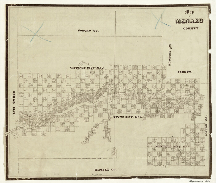
Map of Menard County

Print $20.00
- Digital $50.00
Map of Menard County
1894
Size: 32.1 x 41.8 inches
1320
Map of Menard County

Print $20.00
- Digital $50.00
Map of Menard County
1871
Size: 18.5 x 23.3 inches
3872
Map of Menard County
Print $20.00
- Digital $50.00
Map of Menard County
1871
Size: 18.2 x 21.6 inches
3873
Map of Menard County
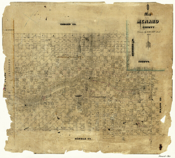
Print $20.00
- Digital $50.00
Map of Menard County
1860
Size: 20.9 x 23.3 inches
3874
Map of Menard County

Print $20.00
- Digital $50.00
Map of Menard County
1898
Size: 19.9 x 43.1 inches
5042
Map of Menard County Texas

Print $20.00
- Digital $50.00
Map of Menard County Texas
1894
Size: 33.0 x 42.5 inches
66927
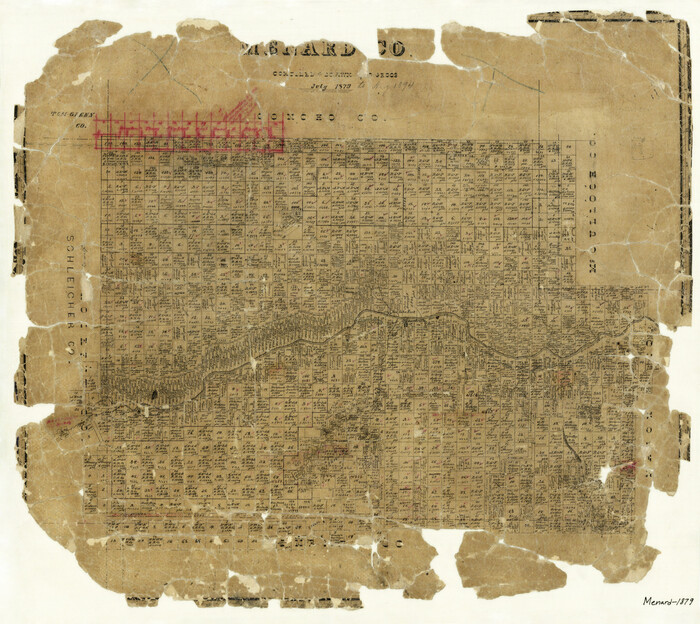
Map of Menard County, Texas

Print $20.00
- Digital $50.00
Map of Menard County, Texas
1879
Size: 18.5 x 24.8 inches
580
Mason County Sketch File 11

Print $8.00
- Digital $50.00
Mason County Sketch File 11
1883
Size: 13.5 x 8.6 inches
30695
Mason County Sketch File 12

Print $22.00
- Digital $50.00
Mason County Sketch File 12
Size: 15.8 x 12.9 inches
30699
Mason County Sketch File 24

Print $22.00
- Digital $50.00
Mason County Sketch File 24
1959
Size: 15.0 x 15.2 inches
30726
Mason County Working Sketch 2

Print $20.00
- Digital $50.00
Mason County Working Sketch 2
1900
Size: 31.6 x 36.3 inches
70838
McCulloch County Sketch File 6

Print $20.00
- Digital $50.00
McCulloch County Sketch File 6
1893
Size: 44.2 x 19.3 inches
10539
Concho County Rolled Sketch 20
Print $20.00
- Digital $50.00
Concho County Rolled Sketch 20
1968
-
Size
26.2 x 38.8 inches
-
Map/Doc
5554
-
Creation Date
1968
Concho County Sketch File 22
Print $20.00
- Digital $50.00
Concho County Sketch File 22
-
Size
24.9 x 18.1 inches
-
Map/Doc
11155
Concho County Working Sketch 12
Print $20.00
- Digital $50.00
Concho County Working Sketch 12
1951
-
Size
23.0 x 27.2 inches
-
Map/Doc
68194
-
Creation Date
1951
Concho County Working Sketch 18
Print $20.00
- Digital $50.00
Concho County Working Sketch 18
1957
-
Size
19.2 x 25.2 inches
-
Map/Doc
68200
-
Creation Date
1957
Concho County Working Sketch 19
Print $20.00
- Digital $50.00
Concho County Working Sketch 19
1957
-
Size
27.3 x 24.9 inches
-
Map/Doc
68201
-
Creation Date
1957
FT. W. & R. G. Ry. Right of Way Map, Whiteland to Lightner, Concho County, Texas
Print $40.00
- Digital $50.00
FT. W. & R. G. Ry. Right of Way Map, Whiteland to Lightner, Concho County, Texas
1918
-
Size
39.6 x 121.3 inches
-
Map/Doc
61412
-
Creation Date
1918
General Highway Map, Menard County, Texas
Print $20.00
General Highway Map, Menard County, Texas
1940
-
Size
18.5 x 24.8 inches
-
Map/Doc
79196
-
Creation Date
1940
General Highway Map, Menard County, Texas
Print $20.00
General Highway Map, Menard County, Texas
1961
-
Size
18.2 x 24.8 inches
-
Map/Doc
79595
-
Creation Date
1961
Kimble County Sketch File 16
Print $30.00
- Digital $50.00
Kimble County Sketch File 16
1886
-
Size
8.5 x 7.9 inches
-
Map/Doc
28942
-
Creation Date
1886
Kimble County Working Sketch 31
Print $20.00
- Digital $50.00
Kimble County Working Sketch 31
1944
-
Size
34.8 x 34.6 inches
-
Map/Doc
70099
-
Creation Date
1944
Kimble County Working Sketch 53
Print $20.00
- Digital $50.00
Kimble County Working Sketch 53
1953
-
Size
24.5 x 35.9 inches
-
Map/Doc
70121
-
Creation Date
1953
Map of Fisher & Miller's Colony made from the records in the office of the District Surveyor of Bexar comprising also all the recent surveys
Print $20.00
- Digital $50.00
Map of Fisher & Miller's Colony made from the records in the office of the District Surveyor of Bexar comprising also all the recent surveys
1855
-
Size
22.6 x 36.2 inches
-
Map/Doc
633
-
Creation Date
1855
Map of Fisher and Miller's Colony made from the records in the Office of the District Surveyor of Bexar comprising also all the recent surveys
Print $20.00
- Digital $50.00
Map of Fisher and Miller's Colony made from the records in the Office of the District Surveyor of Bexar comprising also all the recent surveys
1855
-
Size
23.7 x 35.2 inches
-
Map/Doc
1971
-
Creation Date
1855
Map of Fisher and Miller's Colony made from the records in the Office of the District Surveyor of Bexar comprising also all the recent surveys
Print $20.00
- Digital $50.00
Map of Fisher and Miller's Colony made from the records in the Office of the District Surveyor of Bexar comprising also all the recent surveys
1855
-
Size
27.2 x 39.6 inches
-
Map/Doc
82026
-
Creation Date
1855
Map of Menard County
Print $20.00
- Digital $50.00
Map of Menard County
1894
-
Size
32.1 x 41.8 inches
-
Map/Doc
1320
-
Creation Date
1894
Map of Menard County
Print $20.00
- Digital $50.00
Map of Menard County
1871
-
Size
18.5 x 23.3 inches
-
Map/Doc
3872
-
Creation Date
1871
Map of Menard County
Print $20.00
- Digital $50.00
Map of Menard County
1871
-
Size
18.2 x 21.6 inches
-
Map/Doc
3873
-
Creation Date
1871
Map of Menard County
Print $20.00
- Digital $50.00
Map of Menard County
1860
-
Size
20.9 x 23.3 inches
-
Map/Doc
3874
-
Creation Date
1860
Map of Menard County
Print $20.00
- Digital $50.00
Map of Menard County
1898
-
Size
19.9 x 43.1 inches
-
Map/Doc
5042
-
Creation Date
1898
Map of Menard County Texas
Print $20.00
- Digital $50.00
Map of Menard County Texas
1894
-
Size
33.0 x 42.5 inches
-
Map/Doc
66927
-
Creation Date
1894
Map of Menard County, Texas
Print $20.00
- Digital $50.00
Map of Menard County, Texas
1879
-
Size
18.5 x 24.8 inches
-
Map/Doc
580
-
Creation Date
1879
Mason County Sketch File 11
Print $8.00
- Digital $50.00
Mason County Sketch File 11
1883
-
Size
13.5 x 8.6 inches
-
Map/Doc
30695
-
Creation Date
1883
Mason County Sketch File 12
Print $22.00
- Digital $50.00
Mason County Sketch File 12
-
Size
15.8 x 12.9 inches
-
Map/Doc
30699
Mason County Sketch File 24
Print $22.00
- Digital $50.00
Mason County Sketch File 24
1959
-
Size
15.0 x 15.2 inches
-
Map/Doc
30726
-
Creation Date
1959
Mason County Working Sketch 2
Print $20.00
- Digital $50.00
Mason County Working Sketch 2
1900
-
Size
31.6 x 36.3 inches
-
Map/Doc
70838
-
Creation Date
1900
McCulloch County Sketch File 6
Print $20.00
- Digital $50.00
McCulloch County Sketch File 6
1893
-
Size
44.2 x 19.3 inches
-
Map/Doc
10539
-
Creation Date
1893
Menard County
Print $20.00
- Digital $50.00
Menard County
1879
-
Size
20.3 x 23.3 inches
-
Map/Doc
3875
-
Creation Date
1879
Menard County

Print $20.00
- Digital $50.00
Menard County
1894
-
Size
32.5 x 42.1 inches
-
Map/Doc
66926
-
Creation Date
1894
Menard County

Print $20.00
- Digital $50.00
Menard County
1942
-
Size
40.1 x 43.7 inches
-
Map/Doc
66928
-
Creation Date
1942
Menard County

Print $20.00
- Digital $50.00
Menard County
1942
-
Size
41.2 x 43.4 inches
-
Map/Doc
73238
-
Creation Date
1942