Randall County Rolled Sketch 9A

Print $20.00
- Digital $50.00
Randall County Rolled Sketch 9A
1985
Size: 44.5 x 35.0 inches
10314
Randall County Rolled Sketch 9B

Print $20.00
- Digital $50.00
Randall County Rolled Sketch 9B
1985
Size: 45.0 x 34.5 inches
9810
Swisher County Working Sketch 6

Print $20.00
- Digital $50.00
Swisher County Working Sketch 6
1979
Size: 23.2 x 19.7 inches
62417
Hale County Working Sketch 4

Print $20.00
- Digital $50.00
Hale County Working Sketch 4
1979
Size: 22.7 x 18.7 inches
63324
Randall County Rolled Sketch 8

Print $20.00
- Digital $50.00
Randall County Rolled Sketch 8
1975
Size: 33.7 x 43.7 inches
10620
Castro County Working Sketch 7

Print $40.00
- Digital $50.00
Castro County Working Sketch 7
1975
Size: 42.8 x 53.1 inches
67902
Swisher County Working Sketch 5

Print $20.00
- Digital $50.00
Swisher County Working Sketch 5
1973
Size: 16.0 x 26.5 inches
62416
General Highway Map, Swisher County, Texas

Print $20.00
General Highway Map, Swisher County, Texas
1961
Size: 18.3 x 25.0 inches
79663
Swisher County Working Sketch 4

Print $20.00
- Digital $50.00
Swisher County Working Sketch 4
1960
Size: 23.0 x 19.9 inches
62415
Swisher County Rolled Sketch 7

Print $40.00
- Digital $50.00
Swisher County Rolled Sketch 7
1955
Size: 65.0 x 43.5 inches
9983
Swisher County Working Sketch 3

Print $20.00
- Digital $50.00
Swisher County Working Sketch 3
1951
Size: 22.9 x 23.4 inches
62414
Swisher County Working Sketch 2

Print $20.00
- Digital $50.00
Swisher County Working Sketch 2
1950
Size: 21.5 x 21.7 inches
62413
Swisher County Working Sketch Graphic Index

Print $20.00
- Digital $50.00
Swisher County Working Sketch Graphic Index
1941
Size: 41.5 x 35.9 inches
76707
Swisher County Rolled Sketch 6

Print $20.00
- Digital $50.00
Swisher County Rolled Sketch 6
1941
Size: 43.0 x 27.6 inches
7907
General Highway Map, Swisher County, Texas

Print $20.00
General Highway Map, Swisher County, Texas
1940
Size: 18.4 x 25.0 inches
79250
Swisher County Sketch File 10

Print $6.00
- Digital $50.00
Swisher County Sketch File 10
1936
Size: 11.0 x 15.9 inches
37631
Briscoe County Rolled Sketch WL

Print $20.00
- Digital $50.00
Briscoe County Rolled Sketch WL
1936
Size: 18.6 x 43.0 inches
5335
Swisher Co. Texas

Print $20.00
- Digital $50.00
Swisher Co. Texas
1936
Size: 36.8 x 38.0 inches
89876
Randall County Working Sketch 3

Print $40.00
- Digital $50.00
Randall County Working Sketch 3
1934
Size: 48.8 x 42.5 inches
71840
Randall County Sketch File 5

Print $20.00
- Digital $50.00
Randall County Sketch File 5
1931
Size: 23.9 x 41.7 inches
10583
Castro County Working Sketch 4

Print $20.00
- Digital $50.00
Castro County Working Sketch 4
1920
Size: 17.0 x 16.2 inches
67899
Working Sketch in Randall and Swisher Cos.

Print $20.00
- Digital $50.00
Working Sketch in Randall and Swisher Cos.
1917
Size: 14.6 x 36.3 inches
93048
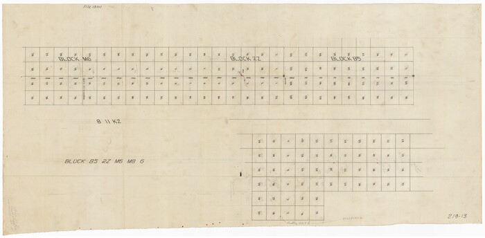
[Sketch of parts of Blocks M6, 2Z and B5]
Print $20.00
- Digital $50.00
[Sketch of parts of Blocks M6, 2Z and B5]
1917
Size: 43.1 x 20.9 inches
91934
Swisher County Sketch File 11

Print $58.00
- Digital $50.00
Swisher County Sketch File 11
1917
Size: 9.1 x 8.3 inches
37633
Swisher County Sketch File 9

Print $4.00
- Digital $50.00
Swisher County Sketch File 9
1916
Size: 11.2 x 8.7 inches
37629
Swisher County Sketch File 19

Print $16.00
- Digital $50.00
Swisher County Sketch File 19
1913
Size: 10.0 x 6.5 inches
37662
Randall County Rolled Sketch 9A
Print $20.00
- Digital $50.00
Randall County Rolled Sketch 9A
1985
-
Size
44.5 x 35.0 inches
-
Map/Doc
10314
-
Creation Date
1985
Randall County Rolled Sketch 9B
Print $20.00
- Digital $50.00
Randall County Rolled Sketch 9B
1985
-
Size
45.0 x 34.5 inches
-
Map/Doc
9810
-
Creation Date
1985
Swisher County Working Sketch 6
Print $20.00
- Digital $50.00
Swisher County Working Sketch 6
1979
-
Size
23.2 x 19.7 inches
-
Map/Doc
62417
-
Creation Date
1979
Hale County Working Sketch 4
Print $20.00
- Digital $50.00
Hale County Working Sketch 4
1979
-
Size
22.7 x 18.7 inches
-
Map/Doc
63324
-
Creation Date
1979
Randall County Rolled Sketch 8
Print $20.00
- Digital $50.00
Randall County Rolled Sketch 8
1975
-
Size
33.7 x 43.7 inches
-
Map/Doc
10620
-
Creation Date
1975
Castro County Working Sketch 7
Print $40.00
- Digital $50.00
Castro County Working Sketch 7
1975
-
Size
42.8 x 53.1 inches
-
Map/Doc
67902
-
Creation Date
1975
Swisher County Working Sketch 5
Print $20.00
- Digital $50.00
Swisher County Working Sketch 5
1973
-
Size
16.0 x 26.5 inches
-
Map/Doc
62416
-
Creation Date
1973
General Highway Map, Swisher County, Texas
Print $20.00
General Highway Map, Swisher County, Texas
1961
-
Size
18.3 x 25.0 inches
-
Map/Doc
79663
-
Creation Date
1961
Swisher County Working Sketch 4
Print $20.00
- Digital $50.00
Swisher County Working Sketch 4
1960
-
Size
23.0 x 19.9 inches
-
Map/Doc
62415
-
Creation Date
1960
Swisher County Rolled Sketch 7
Print $40.00
- Digital $50.00
Swisher County Rolled Sketch 7
1955
-
Size
65.0 x 43.5 inches
-
Map/Doc
9983
-
Creation Date
1955
Swisher County Working Sketch 3
Print $20.00
- Digital $50.00
Swisher County Working Sketch 3
1951
-
Size
22.9 x 23.4 inches
-
Map/Doc
62414
-
Creation Date
1951
Swisher County Working Sketch 2
Print $20.00
- Digital $50.00
Swisher County Working Sketch 2
1950
-
Size
21.5 x 21.7 inches
-
Map/Doc
62413
-
Creation Date
1950
Swisher County

Print $20.00
- Digital $50.00
Swisher County
1941
-
Size
45.2 x 38.0 inches
-
Map/Doc
63055
-
Creation Date
1941
Swisher County

Print $20.00
- Digital $50.00
Swisher County
1941
-
Size
44.3 x 38.1 inches
-
Map/Doc
73297
-
Creation Date
1941
Swisher County

Print $20.00
- Digital $50.00
Swisher County
1941
-
Size
40.9 x 35.2 inches
-
Map/Doc
77430
-
Creation Date
1941
Swisher County

Print $20.00
- Digital $50.00
Swisher County
1941
-
Size
44.7 x 38.5 inches
-
Map/Doc
95648
-
Creation Date
1941
Swisher County Working Sketch Graphic Index
Print $20.00
- Digital $50.00
Swisher County Working Sketch Graphic Index
1941
-
Size
41.5 x 35.9 inches
-
Map/Doc
76707
-
Creation Date
1941
Swisher County Rolled Sketch 6
Print $20.00
- Digital $50.00
Swisher County Rolled Sketch 6
1941
-
Size
43.0 x 27.6 inches
-
Map/Doc
7907
-
Creation Date
1941
General Highway Map, Swisher County, Texas
Print $20.00
General Highway Map, Swisher County, Texas
1940
-
Size
18.4 x 25.0 inches
-
Map/Doc
79250
-
Creation Date
1940
Swisher County Sketch File 10
Print $6.00
- Digital $50.00
Swisher County Sketch File 10
1936
-
Size
11.0 x 15.9 inches
-
Map/Doc
37631
-
Creation Date
1936
Briscoe County Rolled Sketch WL
Print $20.00
- Digital $50.00
Briscoe County Rolled Sketch WL
1936
-
Size
18.6 x 43.0 inches
-
Map/Doc
5335
-
Creation Date
1936
Swisher Co. Texas
Print $20.00
- Digital $50.00
Swisher Co. Texas
1936
-
Size
36.8 x 38.0 inches
-
Map/Doc
89876
-
Creation Date
1936
Randall County Working Sketch 3
Print $40.00
- Digital $50.00
Randall County Working Sketch 3
1934
-
Size
48.8 x 42.5 inches
-
Map/Doc
71840
-
Creation Date
1934
Randall County Sketch File 5
Print $20.00
- Digital $50.00
Randall County Sketch File 5
1931
-
Size
23.9 x 41.7 inches
-
Map/Doc
10583
-
Creation Date
1931
Castro County Working Sketch 4
Print $20.00
- Digital $50.00
Castro County Working Sketch 4
1920
-
Size
17.0 x 16.2 inches
-
Map/Doc
67899
-
Creation Date
1920
Working Sketch in Randall and Swisher Cos.
Print $20.00
- Digital $50.00
Working Sketch in Randall and Swisher Cos.
1917
-
Size
14.6 x 36.3 inches
-
Map/Doc
93048
-
Creation Date
1917
[Sketch of parts of Blocks M6, 2Z and B5]
Print $20.00
- Digital $50.00
[Sketch of parts of Blocks M6, 2Z and B5]
1917
-
Size
43.1 x 20.9 inches
-
Map/Doc
91934
-
Creation Date
1917
Swisher County Sketch File 11
Print $58.00
- Digital $50.00
Swisher County Sketch File 11
1917
-
Size
9.1 x 8.3 inches
-
Map/Doc
37633
-
Creation Date
1917
Swisher County Sketch File 9
Print $4.00
- Digital $50.00
Swisher County Sketch File 9
1916
-
Size
11.2 x 8.7 inches
-
Map/Doc
37629
-
Creation Date
1916
Swisher County Sketch File 19
Print $16.00
- Digital $50.00
Swisher County Sketch File 19
1913
-
Size
10.0 x 6.5 inches
-
Map/Doc
37662
-
Creation Date
1913