Arlington Street Map & Guide

Digital $50.00
Arlington Street Map & Guide
Size: 35.5 x 23.2 inches
94436
Arlington Street Map & Guide

Digital $50.00
Arlington Street Map & Guide
Size: 35.4 x 23.0 inches
94437
Dallas County Sketch File 10

Print $4.00
- Digital $50.00
Dallas County Sketch File 10
1858
Size: 12.5 x 8.2 inches
20414
Dallas County Sketch File 11

Print $12.00
- Digital $50.00
Dallas County Sketch File 11
1860
Size: 8.5 x 7.9 inches
20416
Dallas County Sketch File 19

Print $20.00
- Digital $50.00
Dallas County Sketch File 19
Size: 17.1 x 17.9 inches
11287
Dallas County Sketch File 19 1/2

Print $4.00
- Digital $50.00
Dallas County Sketch File 19 1/2
Size: 9.9 x 8.2 inches
20439
Dallas County Working Sketch 4

Print $20.00
- Digital $50.00
Dallas County Working Sketch 4
1935
Size: 24.1 x 30.4 inches
68570


Dallas/Fort Worth Street Map & Visitor Guide

Dallas/Fort Worth Street Map & Visitor Guide
2000
Size: 35.6 x 23.2 inches
94295
Denton County Sketch File 13

Print $12.00
- Digital $50.00
Denton County Sketch File 13
1856
Size: 12.3 x 7.9 inches
20713
Denton County Sketch File 43

Print $20.00
- Digital $50.00
Denton County Sketch File 43
2006
Size: 11.0 x 8.5 inches
83610
Denton County Working Sketch 20

Print $20.00
- Digital $50.00
Denton County Working Sketch 20
1978
Size: 31.6 x 33.2 inches
68625
Denton County Working Sketch 24

Print $20.00
- Digital $50.00
Denton County Working Sketch 24
1989
Size: 22.2 x 30.0 inches
68629
Ellis County Sketch File 12

Print $60.00
- Digital $50.00
Ellis County Sketch File 12
1860
Size: 12.9 x 16.1 inches
21849
Fort Worth, Tarrant Co[unty], Texas
Print $20.00
Fort Worth, Tarrant Co[unty], Texas
1876
Size: 14.9 x 18.0 inches
89081
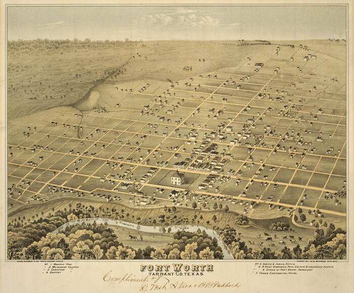
Fort Worth, Tex. "The Queen of the Prairies", County Seat of Tarrant County

Print $20.00
Fort Worth, Tex. "The Queen of the Prairies", County Seat of Tarrant County
1886
Size: 28.8 x 38.6 inches
93470
Fort Worth, Tex. "The Queen of the Prairies," County Seat of Tarrant County

Print $20.00
Fort Worth, Tex. "The Queen of the Prairies," County Seat of Tarrant County
1886
Size: 26.0 x 33.3 inches
89082
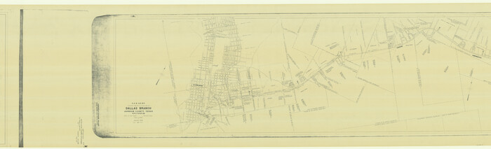
G. C. & S. F. Ry. Alinement [sic] and Right of Way Map of Dallas Branch, Johnson County, Texas
Print $40.00
- Digital $50.00
G. C. & S. F. Ry. Alinement [sic] and Right of Way Map of Dallas Branch, Johnson County, Texas
1925
Size: 38.0 x 125.2 inches
64650
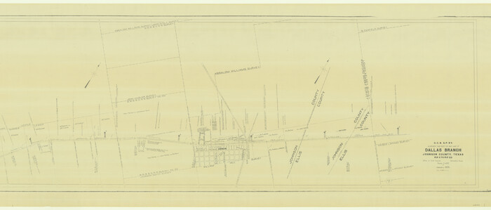
G. C. & S. F. Ry. Alinement [sic] and Right of Way Map of Dallas Branch, Johnson County, Texas
Print $40.00
- Digital $50.00
G. C. & S. F. Ry. Alinement [sic] and Right of Way Map of Dallas Branch, Johnson County, Texas
1925
Size: 37.6 x 87.9 inches
64652
G. C. & S. F. Ry. Northern-Division, Alignment and Right of Way Map, Weatherford Branch, Johnson and Hood Counties, Texas

Print $40.00
- Digital $50.00
G. C. & S. F. Ry. Northern-Division, Alignment and Right of Way Map, Weatherford Branch, Johnson and Hood Counties, Texas
1935
Size: 37.2 x 121.7 inches
64647
G. C. & S. F. Ry. Northern-Division, Alignment and Right of Way Map, Weatherford Branch, Johnson and Hood Counties, Texas

Print $40.00
- Digital $50.00
G. C. & S. F. Ry. Northern-Division, Alignment and Right of Way Map, Weatherford Branch, Johnson and Hood Counties, Texas
1935
Size: 37.8 x 100.5 inches
64649
G. C. & S. F., Main Line, Texas, Right of Way map, Rio Vista to Crowley

Print $40.00
- Digital $50.00
G. C. & S. F., Main Line, Texas, Right of Way map, Rio Vista to Crowley
1910
Size: 38.1 x 122.4 inches
64653
G. C. & S. F., Main Line, Texas, Right of Way map, Rio Vista to Crowley

Print $40.00
- Digital $50.00
G. C. & S. F., Main Line, Texas, Right of Way map, Rio Vista to Crowley
1916
Size: 40.2 x 92.0 inches
64654
G.C. & S.F. Ry. Main Line, Texas, Right of Way Map, Keeler to Haslet

Print $40.00
- Digital $50.00
G.C. & S.F. Ry. Main Line, Texas, Right of Way Map, Keeler to Haslet
1916
Size: 25.1 x 122.6 inches
64545
Arlington Street Map & Guide
Digital $50.00
Arlington Street Map & Guide
-
Size
35.5 x 23.2 inches
-
Map/Doc
94436
Arlington Street Map & Guide
Digital $50.00
Arlington Street Map & Guide
-
Size
35.4 x 23.0 inches
-
Map/Doc
94437
Dallas County Boundary File 9

Print $6.00
- Digital $50.00
Dallas County Boundary File 9
2008
-
Map/Doc
88850
-
Creation Date
2008
Dallas County Sketch File 10
Print $4.00
- Digital $50.00
Dallas County Sketch File 10
1858
-
Size
12.5 x 8.2 inches
-
Map/Doc
20414
-
Creation Date
1858
Dallas County Sketch File 11
Print $12.00
- Digital $50.00
Dallas County Sketch File 11
1860
-
Size
8.5 x 7.9 inches
-
Map/Doc
20416
-
Creation Date
1860
Dallas County Sketch File 19
Print $20.00
- Digital $50.00
Dallas County Sketch File 19
-
Size
17.1 x 17.9 inches
-
Map/Doc
11287
Dallas County Sketch File 19 1/2
Print $4.00
- Digital $50.00
Dallas County Sketch File 19 1/2
-
Size
9.9 x 8.2 inches
-
Map/Doc
20439
Dallas County Working Sketch 4
Print $20.00
- Digital $50.00
Dallas County Working Sketch 4
1935
-
Size
24.1 x 30.4 inches
-
Map/Doc
68570
-
Creation Date
1935
Dallas/Fort Worth Street Map & Visitor Guide
Dallas/Fort Worth Street Map & Visitor Guide
2000
-
Size
35.6 x 23.2 inches
-
Map/Doc
94295
-
Creation Date
2000
Denton County Sketch File 13
Print $12.00
- Digital $50.00
Denton County Sketch File 13
1856
-
Size
12.3 x 7.9 inches
-
Map/Doc
20713
-
Creation Date
1856
Denton County Sketch File 43
Print $20.00
- Digital $50.00
Denton County Sketch File 43
2006
-
Size
11.0 x 8.5 inches
-
Map/Doc
83610
-
Creation Date
2006
Denton County Working Sketch 20
Print $20.00
- Digital $50.00
Denton County Working Sketch 20
1978
-
Size
31.6 x 33.2 inches
-
Map/Doc
68625
-
Creation Date
1978
Denton County Working Sketch 24
Print $20.00
- Digital $50.00
Denton County Working Sketch 24
1989
-
Size
22.2 x 30.0 inches
-
Map/Doc
68629
-
Creation Date
1989
Ellis County Sketch File 12
Print $60.00
- Digital $50.00
Ellis County Sketch File 12
1860
-
Size
12.9 x 16.1 inches
-
Map/Doc
21849
-
Creation Date
1860
Fort Worth Street Guide

Fort Worth Street Guide
2000
-
Size
37.6 x 58.7 inches
-
Map/Doc
96853
-
Creation Date
2000
Fort Worth Street Guide

Fort Worth Street Guide
2000
-
Size
58.7 x 37.6 inches
-
Map/Doc
96854
-
Creation Date
2000
Fort Worth and Vicinity

Fort Worth and Vicinity
1997
-
Size
38.7 x 26.9 inches
-
Map/Doc
96851
-
Creation Date
1997
Fort Worth and Vicinity

Fort Worth and Vicinity
1997
-
Size
38.6 x 27.1 inches
-
Map/Doc
96852
-
Creation Date
1997
Fort Worth, Tarrant Co[unty], Texas
Print $20.00
Fort Worth, Tarrant Co[unty], Texas
1876
-
Size
14.9 x 18.0 inches
-
Map/Doc
89081
-
Creation Date
1876
Fort Worth, Tex. "The Queen of the Prairies", County Seat of Tarrant County
Print $20.00
Fort Worth, Tex. "The Queen of the Prairies", County Seat of Tarrant County
1886
-
Size
28.8 x 38.6 inches
-
Map/Doc
93470
-
Creation Date
1886
Fort Worth, Tex. "The Queen of the Prairies," County Seat of Tarrant County
Print $20.00
Fort Worth, Tex. "The Queen of the Prairies," County Seat of Tarrant County
1886
-
Size
26.0 x 33.3 inches
-
Map/Doc
89082
-
Creation Date
1886
G. C. & S. F. Ry. Alinement [sic] and Right of Way Map of Dallas Branch, Johnson County, Texas
Print $40.00
- Digital $50.00
G. C. & S. F. Ry. Alinement [sic] and Right of Way Map of Dallas Branch, Johnson County, Texas
1925
-
Size
38.0 x 125.2 inches
-
Map/Doc
64650
-
Creation Date
1925
G. C. & S. F. Ry. Alinement [sic] and Right of Way Map of Dallas Branch, Johnson County, Texas
Print $40.00
- Digital $50.00
G. C. & S. F. Ry. Alinement [sic] and Right of Way Map of Dallas Branch, Johnson County, Texas
1925
-
Size
37.6 x 87.9 inches
-
Map/Doc
64652
-
Creation Date
1925
G. C. & S. F. Ry. Northern-Division, Alignment and Right of Way Map, Weatherford Branch, Johnson and Hood Counties, Texas
Print $40.00
- Digital $50.00
G. C. & S. F. Ry. Northern-Division, Alignment and Right of Way Map, Weatherford Branch, Johnson and Hood Counties, Texas
1935
-
Size
37.2 x 121.7 inches
-
Map/Doc
64647
-
Creation Date
1935
G. C. & S. F. Ry. Northern-Division, Alignment and Right of Way Map, Weatherford Branch, Johnson and Hood Counties, Texas
Print $40.00
- Digital $50.00
G. C. & S. F. Ry. Northern-Division, Alignment and Right of Way Map, Weatherford Branch, Johnson and Hood Counties, Texas
1935
-
Size
37.8 x 100.5 inches
-
Map/Doc
64649
-
Creation Date
1935
G. C. & S. F., Main Line, Texas, Right of Way map, Rio Vista to Crowley
Print $40.00
- Digital $50.00
G. C. & S. F., Main Line, Texas, Right of Way map, Rio Vista to Crowley
1910
-
Size
38.1 x 122.4 inches
-
Map/Doc
64653
-
Creation Date
1910
G. C. & S. F., Main Line, Texas, Right of Way map, Rio Vista to Crowley
Print $40.00
- Digital $50.00
G. C. & S. F., Main Line, Texas, Right of Way map, Rio Vista to Crowley
1916
-
Size
40.2 x 92.0 inches
-
Map/Doc
64654
-
Creation Date
1916
G.C. & S.F. Ry. Main Line, Texas, Right of Way Map, Keeler to Haslet
Print $40.00
- Digital $50.00
G.C. & S.F. Ry. Main Line, Texas, Right of Way Map, Keeler to Haslet
1916
-
Size
25.1 x 122.6 inches
-
Map/Doc
64545
-
Creation Date
1916