Wood County Rolled Sketch 1

Print $40.00
- Digital $50.00
Wood County Rolled Sketch 1
1941
Size: 53.2 x 43.8 inches
10159
Wood County Rolled Sketch 2

Print $40.00
- Digital $50.00
Wood County Rolled Sketch 2
1941
Size: 52.6 x 24.9 inches
10160
Wood County Rolled Sketch 5

Print $20.00
- Digital $50.00
Wood County Rolled Sketch 5
1950
Size: 36.8 x 40.2 inches
10161
Smith County Rolled Sketch 6E2

Print $20.00
- Digital $50.00
Smith County Rolled Sketch 6E2
1960
Size: 27.6 x 22.7 inches
10613
Upshur County Sketch File 19

Print $40.00
- Digital $50.00
Upshur County Sketch File 19
Size: 17.9 x 22.2 inches
12507
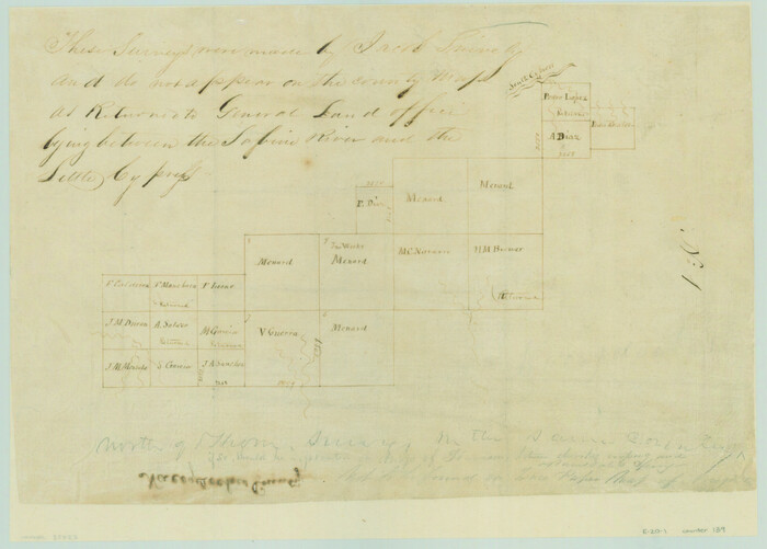
[Surveys between the Sabine River and Little Cypress Creek]
Print $3.00
- Digital $50.00
[Surveys between the Sabine River and Little Cypress Creek]
1840
Size: 9.3 x 13.0 inches
139
Gregg County Sketch File 1D

Print $4.00
- Digital $50.00
Gregg County Sketch File 1D
1848
Size: 12.7 x 8.5 inches
24543
Hopkins County Sketch File 15

Print $4.00
- Digital $50.00
Hopkins County Sketch File 15
Size: 10.6 x 7.3 inches
26711
Hopkins County Sketch File 19

Print $4.00
- Digital $50.00
Hopkins County Sketch File 19
1870
Size: 10.2 x 8.0 inches
26723
Hunt County Sketch File 8

Print $4.00
- Digital $50.00
Hunt County Sketch File 8
1848
Size: 8.2 x 12.7 inches
27097
Kaufman County Sketch File 7

Print $5.00
- Digital $50.00
Kaufman County Sketch File 7
1847
Size: 8.3 x 10.1 inches
28636
[Surveys in Hopkins and Wood Counties]
Print $20.00
- Digital $50.00
[Surveys in Hopkins and Wood Counties]
1838
Size: 24.7 x 31.7 inches
365
Upshur County Sketch File 6

Print $4.00
- Digital $50.00
Upshur County Sketch File 6
1855
Size: 8.7 x 13.0 inches
38742
Wood County Sketch File 1

Print $4.00
- Digital $50.00
Wood County Sketch File 1
Size: 12.7 x 7.9 inches
40629
Wood County Sketch File 2

Print $4.00
- Digital $50.00
Wood County Sketch File 2
1848
Size: 8.3 x 6.4 inches
40631
Wood County Sketch File 3

Print $4.00
- Digital $50.00
Wood County Sketch File 3
1848
Size: 10.1 x 8.1 inches
40633
Wood County Sketch File 4

Print $4.00
- Digital $50.00
Wood County Sketch File 4
1855
Size: 10.2 x 8.1 inches
40635
Wood County Sketch File 5

Print $4.00
- Digital $50.00
Wood County Sketch File 5
1848
Size: 10.7 x 9.0 inches
40637
Wood County Sketch File 5a

Print $4.00
- Digital $50.00
Wood County Sketch File 5a
1857
Size: 10.1 x 8.0 inches
40639
Wood County Sketch File 6

Print $8.00
- Digital $50.00
Wood County Sketch File 6
1877
Size: 8.2 x 5.4 inches
40641
Wood County Sketch File 7

Print $17.00
- Digital $50.00
Wood County Sketch File 7
1848
Size: 11.9 x 7.7 inches
40645
Wood County Sketch File 8

Print $6.00
- Digital $50.00
Wood County Sketch File 8
1850
Size: 12.5 x 8.3 inches
40653
Wood County Sketch File 9

Print $4.00
- Digital $50.00
Wood County Sketch File 9
1852
Size: 7.4 x 8.9 inches
40656
Wood County Sketch File 10

Print $12.00
- Digital $50.00
Wood County Sketch File 10
1850
Size: 8.3 x 12.8 inches
40658
Wood County Sketch File 11

Print $4.00
- Digital $50.00
Wood County Sketch File 11
1858
Size: 12.7 x 8.0 inches
40664
Wood County Sketch File 12

Print $4.00
- Digital $50.00
Wood County Sketch File 12
1862
Size: 12.8 x 8.3 inches
40666
Wood County Sketch File 13

Print $24.00
- Digital $50.00
Wood County Sketch File 13
1866
Size: 12.5 x 7.6 inches
40668
Wood County Sketch File 14

Print $46.00
- Digital $50.00
Wood County Sketch File 14
1907
Size: 14.3 x 8.7 inches
40671
Wood County Sketch File 15

Print $5.00
- Digital $50.00
Wood County Sketch File 15
1835
Size: 11.0 x 16.3 inches
40694
Wood County Rolled Sketch 1
Print $40.00
- Digital $50.00
Wood County Rolled Sketch 1
1941
-
Size
53.2 x 43.8 inches
-
Map/Doc
10159
-
Creation Date
1941
Wood County Rolled Sketch 2
Print $40.00
- Digital $50.00
Wood County Rolled Sketch 2
1941
-
Size
52.6 x 24.9 inches
-
Map/Doc
10160
-
Creation Date
1941
Wood County Rolled Sketch 5
Print $20.00
- Digital $50.00
Wood County Rolled Sketch 5
1950
-
Size
36.8 x 40.2 inches
-
Map/Doc
10161
-
Creation Date
1950
Smith County Rolled Sketch 6E2
Print $20.00
- Digital $50.00
Smith County Rolled Sketch 6E2
1960
-
Size
27.6 x 22.7 inches
-
Map/Doc
10613
-
Creation Date
1960
Upshur County Sketch File 19
Print $40.00
- Digital $50.00
Upshur County Sketch File 19
-
Size
17.9 x 22.2 inches
-
Map/Doc
12507
[Surveys between the Sabine River and Little Cypress Creek]
Print $3.00
- Digital $50.00
[Surveys between the Sabine River and Little Cypress Creek]
1840
-
Size
9.3 x 13.0 inches
-
Map/Doc
139
-
Creation Date
1840
Wood Co.

Print $20.00
- Digital $50.00
Wood Co.
1895
-
Size
33.7 x 34.1 inches
-
Map/Doc
16933
-
Creation Date
1895
Gregg County Sketch File 1D
Print $4.00
- Digital $50.00
Gregg County Sketch File 1D
1848
-
Size
12.7 x 8.5 inches
-
Map/Doc
24543
-
Creation Date
1848
Hopkins County Sketch File 15
Print $4.00
- Digital $50.00
Hopkins County Sketch File 15
-
Size
10.6 x 7.3 inches
-
Map/Doc
26711
Hopkins County Sketch File 19
Print $4.00
- Digital $50.00
Hopkins County Sketch File 19
1870
-
Size
10.2 x 8.0 inches
-
Map/Doc
26723
-
Creation Date
1870
Hunt County Sketch File 8
Print $4.00
- Digital $50.00
Hunt County Sketch File 8
1848
-
Size
8.2 x 12.7 inches
-
Map/Doc
27097
-
Creation Date
1848
Kaufman County Sketch File 7
Print $5.00
- Digital $50.00
Kaufman County Sketch File 7
1847
-
Size
8.3 x 10.1 inches
-
Map/Doc
28636
-
Creation Date
1847
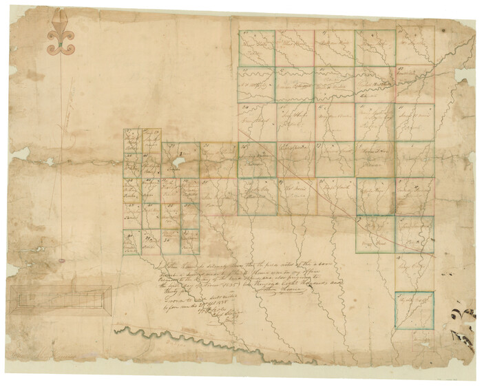
[Surveys in Hopkins and Wood Counties]
Print $20.00
- Digital $50.00
[Surveys in Hopkins and Wood Counties]
1838
-
Size
24.7 x 31.7 inches
-
Map/Doc
365
-
Creation Date
1838
Upshur County Sketch File 6
Print $4.00
- Digital $50.00
Upshur County Sketch File 6
1855
-
Size
8.7 x 13.0 inches
-
Map/Doc
38742
-
Creation Date
1855
Wood County Sketch File 1
Print $4.00
- Digital $50.00
Wood County Sketch File 1
-
Size
12.7 x 7.9 inches
-
Map/Doc
40629
Wood County Sketch File 2
Print $4.00
- Digital $50.00
Wood County Sketch File 2
1848
-
Size
8.3 x 6.4 inches
-
Map/Doc
40631
-
Creation Date
1848
Wood County Sketch File 3
Print $4.00
- Digital $50.00
Wood County Sketch File 3
1848
-
Size
10.1 x 8.1 inches
-
Map/Doc
40633
-
Creation Date
1848
Wood County Sketch File 4
Print $4.00
- Digital $50.00
Wood County Sketch File 4
1855
-
Size
10.2 x 8.1 inches
-
Map/Doc
40635
-
Creation Date
1855
Wood County Sketch File 5
Print $4.00
- Digital $50.00
Wood County Sketch File 5
1848
-
Size
10.7 x 9.0 inches
-
Map/Doc
40637
-
Creation Date
1848
Wood County Sketch File 5a
Print $4.00
- Digital $50.00
Wood County Sketch File 5a
1857
-
Size
10.1 x 8.0 inches
-
Map/Doc
40639
-
Creation Date
1857
Wood County Sketch File 6
Print $8.00
- Digital $50.00
Wood County Sketch File 6
1877
-
Size
8.2 x 5.4 inches
-
Map/Doc
40641
-
Creation Date
1877
Wood County Sketch File 7
Print $17.00
- Digital $50.00
Wood County Sketch File 7
1848
-
Size
11.9 x 7.7 inches
-
Map/Doc
40645
-
Creation Date
1848
Wood County Sketch File 8
Print $6.00
- Digital $50.00
Wood County Sketch File 8
1850
-
Size
12.5 x 8.3 inches
-
Map/Doc
40653
-
Creation Date
1850
Wood County Sketch File 9
Print $4.00
- Digital $50.00
Wood County Sketch File 9
1852
-
Size
7.4 x 8.9 inches
-
Map/Doc
40656
-
Creation Date
1852
Wood County Sketch File 10
Print $12.00
- Digital $50.00
Wood County Sketch File 10
1850
-
Size
8.3 x 12.8 inches
-
Map/Doc
40658
-
Creation Date
1850
Wood County Sketch File 11
Print $4.00
- Digital $50.00
Wood County Sketch File 11
1858
-
Size
12.7 x 8.0 inches
-
Map/Doc
40664
-
Creation Date
1858
Wood County Sketch File 12
Print $4.00
- Digital $50.00
Wood County Sketch File 12
1862
-
Size
12.8 x 8.3 inches
-
Map/Doc
40666
-
Creation Date
1862
Wood County Sketch File 13
Print $24.00
- Digital $50.00
Wood County Sketch File 13
1866
-
Size
12.5 x 7.6 inches
-
Map/Doc
40668
-
Creation Date
1866
Wood County Sketch File 14
Print $46.00
- Digital $50.00
Wood County Sketch File 14
1907
-
Size
14.3 x 8.7 inches
-
Map/Doc
40671
-
Creation Date
1907
Wood County Sketch File 15
Print $5.00
- Digital $50.00
Wood County Sketch File 15
1835
-
Size
11.0 x 16.3 inches
-
Map/Doc
40694
-
Creation Date
1835