A Chart of the Internal Part of Louisiana

Print $20.00
- Digital $50.00
A Chart of the Internal Part of Louisiana
1810
Size: 19.0 x 17.3 inches
95155
A Comprehensive Atlas Geographical, Historical & Commercial

A Comprehensive Atlas Geographical, Historical & Commercial
Size: 13.0 x 10.7 inches
95959
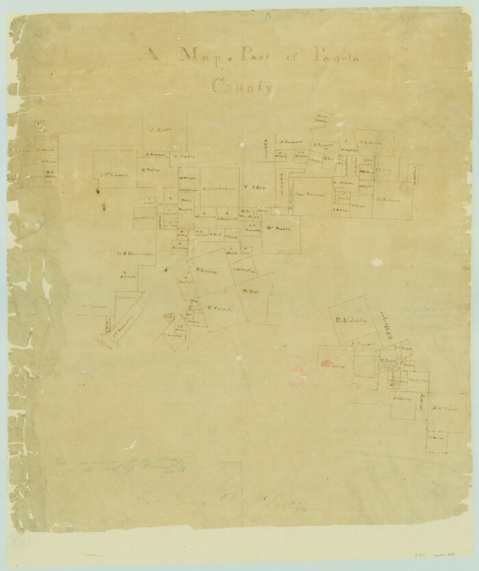
A Map of Part of Panola County [Judicial District]
Print $20.00
- Digital $50.00
A Map of Part of Panola County [Judicial District]
1841
Size: 18.3 x 15.4 inches
328
A Map of the Internal Provinces of New Spain

Print $20.00
- Digital $50.00
A Map of the Internal Provinces of New Spain
1810
Size: 19.8 x 21.0 inches
95156
A Map of the West-Indies & c., Mexico or New Spain. Also ye trade winds and ye several tracts made by ye Galeons and Flota from place to place

Print $20.00
- Digital $50.00
A Map of the West-Indies & c., Mexico or New Spain. Also ye trade winds and ye several tracts made by ye Galeons and Flota from place to place
1729
Size: 9.5 x 13.6 inches
94087
A Plat of the League of land surveyed on the south-west side of the Rio San Bernardo between it and the Bay-Prairie

Print $20.00
- Digital $50.00
A Plat of the League of land surveyed on the south-west side of the Rio San Bernardo between it and the Bay-Prairie
1831
Size: 37.3 x 24.0 inches
13
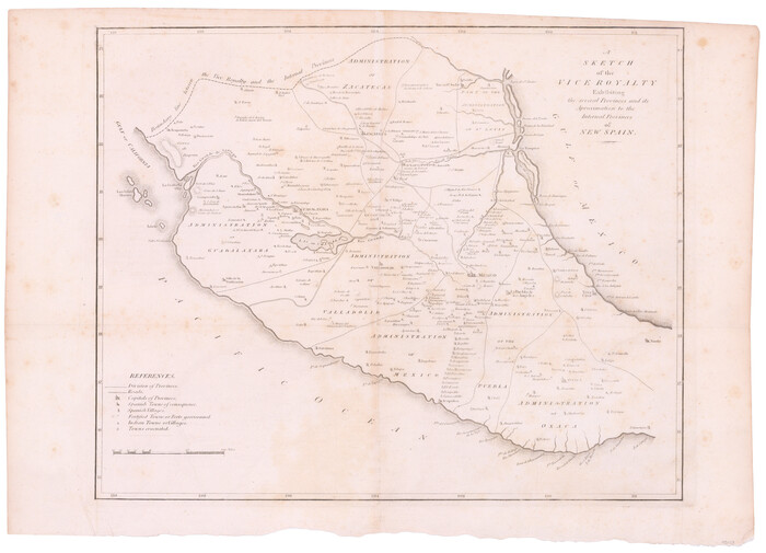
A Sketch of the Vice Royalty exhibiting the several Provinces and its Aproximation [sic] to the Internal Provinces of New Spain
Print $20.00
- Digital $50.00
A Sketch of the Vice Royalty exhibiting the several Provinces and its Aproximation [sic] to the Internal Provinces of New Spain
1810
Size: 15.2 x 21.1 inches
95157
A sketch of surveys made on the coast east of Bolivar Point

Print $20.00
- Digital $50.00
A sketch of surveys made on the coast east of Bolivar Point
1841
Size: 9.1 x 22.0 inches
22
A sketch of the map of the Land Dist. of Liberty

Print $2.00
- Digital $50.00
A sketch of the map of the Land Dist. of Liberty
Size: 6.3 x 3.9 inches
353

Atlas E, Sketch 29 (E-29)

Print $20.00
- Digital $50.00
Atlas E, Sketch 29 (E-29)
Size: 22.4 x 33.2 inches
78363
Atlas Geográfico, Estadístico é Histórico de la República Mexicana

Atlas Geográfico, Estadístico é Histórico de la República Mexicana
95689
Atlas Pintoresco e Historico de los Estados Unidos Mexicanos

Atlas Pintoresco e Historico de los Estados Unidos Mexicanos
96796
Austin Empresario Colony. April 27, 1825

Print $20.00
Austin Empresario Colony. April 27, 1825
2020
Size: 18.1 x 21.6 inches
95979
Austin Empresario Colony. February 25, 1831

Print $20.00
Austin Empresario Colony. February 25, 1831
2020
Size: 17.0 x 21.7 inches
95983
Austin Empresario Colony. January 17, 1821/February 18, 1823

Print $20.00
Austin Empresario Colony. January 17, 1821/February 18, 1823
2020
Size: 18.8 x 21.6 inches
95978
Austin Empresario Colony. July 9, 1828

Print $20.00
Austin Empresario Colony. July 9, 1828
2020
Size: 16.4 x 21.7 inches
95982
Austin Empresario Colony. March 27, 1827

Print $20.00
Austin Empresario Colony. March 27, 1827
2020
Size: 18.0 x 21.6 inches
95980
Austin Empresario Colony. November 20, 1827

Print $20.00
Austin Empresario Colony. November 20, 1827
2020
Size: 14.7 x 21.7 inches
95981
Authors’ Interpretation of Figure A1029.1, Red River and Shelby Counties, Undated

Print $20.00
Authors’ Interpretation of Figure A1029.1, Red River and Shelby Counties, Undated
2020
Size: 20.1 x 21.7 inches
96404

Beales and Royuela Empresario Colony. March 14, 1832

Print $20.00
Beales and Royuela Empresario Colony. March 14, 1832
2020
Size: 19.4 x 21.6 inches
95984
Burnet Empresario Colony. December 22, 1826

Print $20.00
Burnet Empresario Colony. December 22, 1826
2020
Size: 12.9 x 21.6 inches
95985
Cameron Empresario Colony. May 21, 1827

Print $20.00
Cameron Empresario Colony. May 21, 1827
2020
Size: 10.7 x 21.7 inches
95986
Cameron Empresario Colony. September 28, 1828

Print $20.00
Cameron Empresario Colony. September 28, 1828
2020
Size: 10.4 x 21.7 inches
95987
Caney Cr. of East San Jacinto

Print $2.00
- Digital $50.00
Caney Cr. of East San Jacinto
Size: 5.3 x 6.7 inches
69745
Carta Eclesiastica

Print $20.00
- Digital $50.00
Carta Eclesiastica
1897
Size: 26.1 x 34.1 inches
96799
Carta Etnografica

Print $20.00
- Digital $50.00
Carta Etnografica
1897
Size: 26.2 x 34.1 inches
96798
A Boundary Atlas of Texas, 1821-1845

Digital $50.00
A Boundary Atlas of Texas, 1821-1845
2020
Jim Tiller’s "A Boundary Atlas of Texas, 1821-1845" is available exclusively as a digital download...
-
Map/Doc
96437
-
Creation Date
2020
A Chart of the Internal Part of Louisiana
Print $20.00
- Digital $50.00
A Chart of the Internal Part of Louisiana
1810
-
Size
19.0 x 17.3 inches
-
Map/Doc
95155
-
Creation Date
1810
A Comprehensive Atlas Geographical, Historical & Commercial
A Comprehensive Atlas Geographical, Historical & Commercial
-
Size
13.0 x 10.7 inches
-
Map/Doc
95959
A Map of Part of Panola County [Judicial District]
Print $20.00
- Digital $50.00
A Map of Part of Panola County [Judicial District]
1841
-
Size
18.3 x 15.4 inches
-
Map/Doc
328
-
Creation Date
1841
A Map of the Internal Provinces of New Spain
Print $20.00
- Digital $50.00
A Map of the Internal Provinces of New Spain
1810
-
Size
19.8 x 21.0 inches
-
Map/Doc
95156
-
Creation Date
1810
A Map of the West-Indies & c., Mexico or New Spain. Also ye trade winds and ye several tracts made by ye Galeons and Flota from place to place
Print $20.00
- Digital $50.00
A Map of the West-Indies & c., Mexico or New Spain. Also ye trade winds and ye several tracts made by ye Galeons and Flota from place to place
1729
-
Size
9.5 x 13.6 inches
-
Map/Doc
94087
-
Creation Date
1729
A Plat of the League of land surveyed on the south-west side of the Rio San Bernardo between it and the Bay-Prairie
Print $20.00
- Digital $50.00
A Plat of the League of land surveyed on the south-west side of the Rio San Bernardo between it and the Bay-Prairie
1831
-
Size
37.3 x 24.0 inches
-
Map/Doc
13
-
Creation Date
1831
A Sketch of the Vice Royalty exhibiting the several Provinces and its Aproximation [sic] to the Internal Provinces of New Spain
Print $20.00
- Digital $50.00
A Sketch of the Vice Royalty exhibiting the several Provinces and its Aproximation [sic] to the Internal Provinces of New Spain
1810
-
Size
15.2 x 21.1 inches
-
Map/Doc
95157
-
Creation Date
1810
A sketch of surveys made on the coast east of Bolivar Point
Print $20.00
- Digital $50.00
A sketch of surveys made on the coast east of Bolivar Point
1841
-
Size
9.1 x 22.0 inches
-
Map/Doc
22
-
Creation Date
1841
A sketch of the map of the Land Dist. of Liberty
Print $2.00
- Digital $50.00
A sketch of the map of the Land Dist. of Liberty
-
Size
6.3 x 3.9 inches
-
Map/Doc
353
Atlas E, Sketch 29 (E-29)
Print $20.00
- Digital $50.00
Atlas E, Sketch 29 (E-29)
-
Size
22.4 x 33.2 inches
-
Map/Doc
78363
Atlas Geográfico, Estadístico é Histórico de la República Mexicana
Atlas Geográfico, Estadístico é Histórico de la República Mexicana
-
Map/Doc
95689
Atlas Pintoresco e Historico de los Estados Unidos Mexicanos
Atlas Pintoresco e Historico de los Estados Unidos Mexicanos
-
Map/Doc
96796
Austin Empresario Colony. April 27, 1825
Print $20.00
Austin Empresario Colony. April 27, 1825
2020
-
Size
18.1 x 21.6 inches
-
Map/Doc
95979
-
Creation Date
2020
Austin Empresario Colony. February 25, 1831
Print $20.00
Austin Empresario Colony. February 25, 1831
2020
-
Size
17.0 x 21.7 inches
-
Map/Doc
95983
-
Creation Date
2020
Austin Empresario Colony. January 17, 1821/February 18, 1823
Print $20.00
Austin Empresario Colony. January 17, 1821/February 18, 1823
2020
-
Size
18.8 x 21.6 inches
-
Map/Doc
95978
-
Creation Date
2020
Austin Empresario Colony. July 9, 1828
Print $20.00
Austin Empresario Colony. July 9, 1828
2020
-
Size
16.4 x 21.7 inches
-
Map/Doc
95982
-
Creation Date
2020
Austin Empresario Colony. March 27, 1827
Print $20.00
Austin Empresario Colony. March 27, 1827
2020
-
Size
18.0 x 21.6 inches
-
Map/Doc
95980
-
Creation Date
2020
Austin Empresario Colony. November 20, 1827
Print $20.00
Austin Empresario Colony. November 20, 1827
2020
-
Size
14.7 x 21.7 inches
-
Map/Doc
95981
-
Creation Date
2020
Authors’ Interpretation of Figure A1029.1, Red River and Shelby Counties, Undated
Print $20.00
Authors’ Interpretation of Figure A1029.1, Red River and Shelby Counties, Undated
2020
-
Size
20.1 x 21.7 inches
-
Map/Doc
96404
-
Creation Date
2020
Beales and Royuela Empresario Colony. March 14, 1832
Print $20.00
Beales and Royuela Empresario Colony. March 14, 1832
2020
-
Size
19.4 x 21.6 inches
-
Map/Doc
95984
-
Creation Date
2020
Burnet Empresario Colony. December 22, 1826
Print $20.00
Burnet Empresario Colony. December 22, 1826
2020
-
Size
12.9 x 21.6 inches
-
Map/Doc
95985
-
Creation Date
2020
Cameron Empresario Colony. May 21, 1827
Print $20.00
Cameron Empresario Colony. May 21, 1827
2020
-
Size
10.7 x 21.7 inches
-
Map/Doc
95986
-
Creation Date
2020
Cameron Empresario Colony. September 28, 1828
Print $20.00
Cameron Empresario Colony. September 28, 1828
2020
-
Size
10.4 x 21.7 inches
-
Map/Doc
95987
-
Creation Date
2020
Caney Cr. of East San Jacinto
Print $2.00
- Digital $50.00
Caney Cr. of East San Jacinto
-
Size
5.3 x 6.7 inches
-
Map/Doc
69745
Carta Agricola

Print $20.00
- Digital $50.00
Carta Agricola
1897
-
Size
26.0 x 34.3 inches
-
Map/Doc
96804
-
Creation Date
1897
Carta Eclesiastica
Print $20.00
- Digital $50.00
Carta Eclesiastica
1897
-
Size
26.1 x 34.1 inches
-
Map/Doc
96799
-
Creation Date
1897
Carta Etnografica
Print $20.00
- Digital $50.00
Carta Etnografica
1897
-
Size
26.2 x 34.1 inches
-
Map/Doc
96798
-
Creation Date
1897