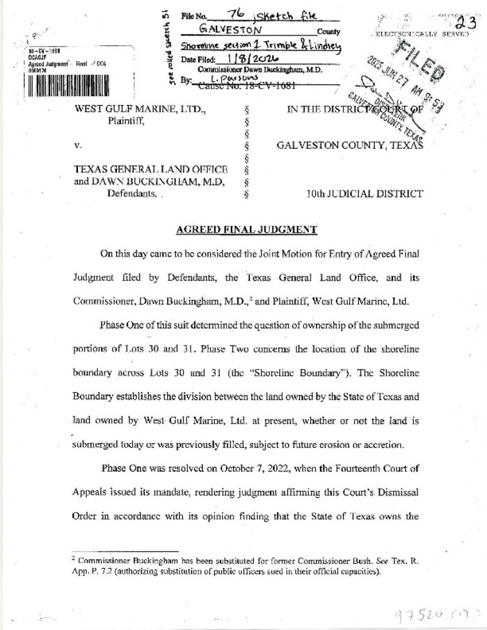
Galveston County Sketch File 76
Print $46.00
Galveston County Sketch File 76
2025
Size: 11.0 x 8.5 inches
97520
Parker County Sketch File 50

Print $68.00
- Digital $50.00
Parker County Sketch File 50
2022
Size: 11.0 x 8.5 inches
96679
Kimble County Sketch File 43

Print $16.00
- Digital $50.00
Kimble County Sketch File 43
2021
Size: 11.0 x 8.5 inches
96811
Webb County Sketch File 73

Print $20.00
- Digital $50.00
Webb County Sketch File 73
2020
Size: 11.0 x 8.5 inches
95917
Bexar County Sketch File 61

Print $61.00
- Digital $50.00
Bexar County Sketch File 61
2019
Size: 11.0 x 8.5 inches
95709
Brown County Sketch File 32

Print $84.00
- Digital $50.00
Brown County Sketch File 32
2018
Size: 11.0 x 8.5 inches
95206
Tarrant County Sketch File 35

Print $50.00
Tarrant County Sketch File 35
2018
Size: 11.0 x 8.5 inches
95394
Tarrant County Sketch File 36

Print $56.00
- Digital $50.00
Tarrant County Sketch File 36
2018
Size: 11.0 x 8.5 inches
95395
Bastrop County Sketch File 14

Print $6.00
- Digital $50.00
Bastrop County Sketch File 14
2018
Size: 11.0 x 8.5 inches
95248
Uvalde County Sketch File 33

Print $56.00
- Digital $50.00
Uvalde County Sketch File 33
2017
Size: 11.0 x 8.5 inches
95251
Loving County Sketch File 10

Print $2.00
- Digital $50.00
Loving County Sketch File 10
2016
Size: 11.0 x 8.5 inches
94115
Wilbarger County Sketch File 28

Print $20.00
- Digital $50.00
Wilbarger County Sketch File 28
2016
Size: 23.9 x 36.2 inches
95324
Wilbarger County Sketch File 29

Print $18.00
- Digital $50.00
Wilbarger County Sketch File 29
2016
Size: 11.0 x 8.5 inches
95325
Roberts County Sketch File 10

Print $32.00
- Digital $50.00
Roberts County Sketch File 10
2016
Size: 11.0 x 8.5 inches
94070
Upshur County Sketch File 22

Print $8.00
- Digital $50.00
Upshur County Sketch File 22
2015
Size: 11.0 x 8.5 inches
93774
Loving County Sketch File 9

Print $36.00
- Digital $50.00
Loving County Sketch File 9
2015
Size: 14.0 x 8.5 inches
93794
Crockett County Sketch File 100

Print $4.00
- Digital $50.00
Crockett County Sketch File 100
2013
Size: 14.0 x 8.5 inches
93663
Frio County Sketch File 23

Print $6.00
- Digital $50.00
Frio County Sketch File 23
2013
Size: 11.0 x 8.5 inches
93418
Lamar County Sketch File 16

Print $166.00
- Digital $50.00
Lamar County Sketch File 16
2013
Size: 11.0 x 8.5 inches
93654
Dimmit County Sketch File 62

Print $8.00
- Digital $50.00
Dimmit County Sketch File 62
2012
Size: 11.0 x 8.5 inches
93631
Archer County Sketch File 31

Print $8.00
- Digital $50.00
Archer County Sketch File 31
2012
Size: 11.0 x 8.5 inches
93322
Wise County Sketch File 54

Print $22.00
- Digital $50.00
Wise County Sketch File 54
2012
Size: 11.0 x 8.5 inches
93553
Galveston County Sketch File 75

Print $12.00
- Digital $50.00
Galveston County Sketch File 75
2011
Size: 11.0 x 8.5 inches
95180
Webb County Sketch File 72

Print $24.00
- Digital $50.00
Webb County Sketch File 72
2011
Size: 11.0 x 8.5 inches
90054
Presidio County Sketch File 122

Print $22.00
- Digital $50.00
Presidio County Sketch File 122
2010
Size: 11.0 x 8.5 inches
89604
Travis County Sketch File 78

Print $102.00
- Digital $50.00
Travis County Sketch File 78
2010
Size: 11.0 x 8.5 inches
90085
Galveston County Sketch File 76
Print $46.00
Galveston County Sketch File 76
2025
-
Size
11.0 x 8.5 inches
-
Map/Doc
97520
-
Creation Date
2025
Mills County Sketch File 29

Print $28.00
Mills County Sketch File 29
2025
-
Map/Doc
97454
-
Creation Date
2025
Sketch File Index

Sketch File Index
2024
This index is a digital version of the old card catalog index that existed in the GLO offices. The...
-
Map/Doc
97348
-
Creation Date
2024
Parker County Sketch File 50
Print $68.00
- Digital $50.00
Parker County Sketch File 50
2022
-
Size
11.0 x 8.5 inches
-
Map/Doc
96679
-
Creation Date
2022
Bee County Sketch File 34

Print $14.00
Bee County Sketch File 34
2022
-
Size
11.0 x 8.5 inches
-
Map/Doc
97030
-
Creation Date
2022
Kimble County Sketch File 43
Print $16.00
- Digital $50.00
Kimble County Sketch File 43
2021
-
Size
11.0 x 8.5 inches
-
Map/Doc
96811
-
Creation Date
2021
Webb County Sketch File 73
Print $20.00
- Digital $50.00
Webb County Sketch File 73
2020
-
Size
11.0 x 8.5 inches
-
Map/Doc
95917
-
Creation Date
2020
Bexar County Sketch File 61
Print $61.00
- Digital $50.00
Bexar County Sketch File 61
2019
-
Size
11.0 x 8.5 inches
-
Map/Doc
95709
-
Creation Date
2019
Brown County Sketch File 32
Print $84.00
- Digital $50.00
Brown County Sketch File 32
2018
-
Size
11.0 x 8.5 inches
-
Map/Doc
95206
-
Creation Date
2018
Tarrant County Sketch File 35
Print $50.00
Tarrant County Sketch File 35
2018
-
Size
11.0 x 8.5 inches
-
Map/Doc
95394
-
Creation Date
2018
Tarrant County Sketch File 36
Print $56.00
- Digital $50.00
Tarrant County Sketch File 36
2018
-
Size
11.0 x 8.5 inches
-
Map/Doc
95395
-
Creation Date
2018
Bastrop County Sketch File 14
Print $6.00
- Digital $50.00
Bastrop County Sketch File 14
2018
-
Size
11.0 x 8.5 inches
-
Map/Doc
95248
-
Creation Date
2018
Uvalde County Sketch File 33
Print $56.00
- Digital $50.00
Uvalde County Sketch File 33
2017
-
Size
11.0 x 8.5 inches
-
Map/Doc
95251
-
Creation Date
2017
Loving County Sketch File 10
Print $2.00
- Digital $50.00
Loving County Sketch File 10
2016
-
Size
11.0 x 8.5 inches
-
Map/Doc
94115
-
Creation Date
2016
Wilbarger County Sketch File 28
Print $20.00
- Digital $50.00
Wilbarger County Sketch File 28
2016
-
Size
23.9 x 36.2 inches
-
Map/Doc
95324
-
Creation Date
2016
Wilbarger County Sketch File 29
Print $18.00
- Digital $50.00
Wilbarger County Sketch File 29
2016
-
Size
11.0 x 8.5 inches
-
Map/Doc
95325
-
Creation Date
2016
Roberts County Sketch File 10
Print $32.00
- Digital $50.00
Roberts County Sketch File 10
2016
-
Size
11.0 x 8.5 inches
-
Map/Doc
94070
-
Creation Date
2016
Upshur County Sketch File 22
Print $8.00
- Digital $50.00
Upshur County Sketch File 22
2015
-
Size
11.0 x 8.5 inches
-
Map/Doc
93774
-
Creation Date
2015
Loving County Sketch File 9
Print $36.00
- Digital $50.00
Loving County Sketch File 9
2015
-
Size
14.0 x 8.5 inches
-
Map/Doc
93794
-
Creation Date
2015
Crockett County Sketch File 100
Print $4.00
- Digital $50.00
Crockett County Sketch File 100
2013
-
Size
14.0 x 8.5 inches
-
Map/Doc
93663
-
Creation Date
2013
Frio County Sketch File 23
Print $6.00
- Digital $50.00
Frio County Sketch File 23
2013
-
Size
11.0 x 8.5 inches
-
Map/Doc
93418
-
Creation Date
2013
Lamar County Sketch File 16
Print $166.00
- Digital $50.00
Lamar County Sketch File 16
2013
-
Size
11.0 x 8.5 inches
-
Map/Doc
93654
-
Creation Date
2013
Dimmit County Sketch File 62
Print $8.00
- Digital $50.00
Dimmit County Sketch File 62
2012
-
Size
11.0 x 8.5 inches
-
Map/Doc
93631
-
Creation Date
2012
Archer County Sketch File 31
Print $8.00
- Digital $50.00
Archer County Sketch File 31
2012
-
Size
11.0 x 8.5 inches
-
Map/Doc
93322
-
Creation Date
2012
Wise County Sketch File 54
Print $22.00
- Digital $50.00
Wise County Sketch File 54
2012
-
Size
11.0 x 8.5 inches
-
Map/Doc
93553
-
Creation Date
2012
Galveston County Sketch File 75
Print $12.00
- Digital $50.00
Galveston County Sketch File 75
2011
-
Size
11.0 x 8.5 inches
-
Map/Doc
95180
-
Creation Date
2011
Webb County Sketch File 72
Print $24.00
- Digital $50.00
Webb County Sketch File 72
2011
-
Size
11.0 x 8.5 inches
-
Map/Doc
90054
-
Creation Date
2011
Presidio County Sketch File 122
Print $22.00
- Digital $50.00
Presidio County Sketch File 122
2010
-
Size
11.0 x 8.5 inches
-
Map/Doc
89604
-
Creation Date
2010
Travis County Sketch File 78
Print $102.00
- Digital $50.00
Travis County Sketch File 78
2010
-
Size
11.0 x 8.5 inches
-
Map/Doc
90085
-
Creation Date
2010
Jones County Sketch File 21

Print $56.00
- Digital $50.00
Jones County Sketch File 21
2010
-
Map/Doc
93292
-
Creation Date
2010