Kimble County Sketch File 43
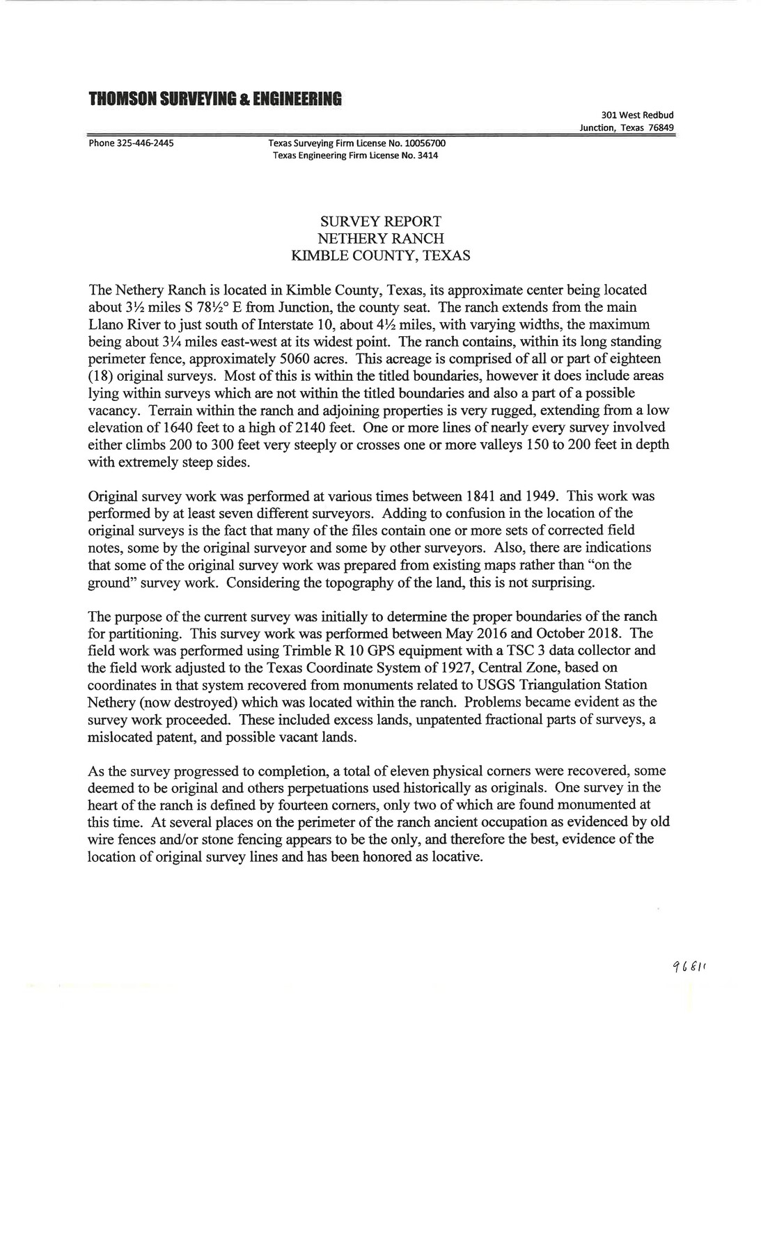
Survey report, Nethery Ranch
-
Map/Doc
96811
-
Collection
General Map Collection
-
Object Dates
2021 (Creation Date)
2022/5/19 (File Date)
-
People and Organizations
C.B. Thomson (Surveyor/Engineer)
-
Counties
Kimble
-
Subjects
Surveying Sketch File
-
Height x Width
11.0 x 8.5 inches
27.9 x 21.6 cm
-
Medium
paper, print
-
Comments
For plat see Kimble County Rolled Sketch 44 (96810).
Related maps
Kimble County Rolled Sketch 44

Print $20.00
- Digital $50.00
Kimble County Rolled Sketch 44
Size 35.9 x 24.2 inches
Map/Doc 96810
Part of: General Map Collection
Tom Green County Sketch File 50

Print $20.00
- Digital $50.00
Tom Green County Sketch File 50
1884
Size 25.4 x 34.5 inches
Map/Doc 12442
Parker County Working Sketch 4

Print $20.00
- Digital $50.00
Parker County Working Sketch 4
1941
Map/Doc 71454
Chambers County Sketch File X

Print $4.00
- Digital $50.00
Chambers County Sketch File X
1936
Size 11.1 x 8.7 inches
Map/Doc 17598
Lipscomb County Boundary File 10

Print $18.00
- Digital $50.00
Lipscomb County Boundary File 10
Size 11.2 x 8.6 inches
Map/Doc 56338
Reagan County

Print $20.00
- Digital $50.00
Reagan County
1903
Size 45.6 x 36.2 inches
Map/Doc 16794
Kleberg County Rolled Sketch 10-11

Print $20.00
- Digital $50.00
Kleberg County Rolled Sketch 10-11
1951
Size 38.2 x 33.8 inches
Map/Doc 9374
Presidio County Sketch File 40

Print $20.00
- Digital $50.00
Presidio County Sketch File 40
1912
Size 24.7 x 23.4 inches
Map/Doc 11715
Fisher County Sketch File 24

Print $37.00
- Digital $50.00
Fisher County Sketch File 24
1875
Size 14.3 x 8.9 inches
Map/Doc 22666
Shelby County Sketch File 11

Print $50.00
- Digital $50.00
Shelby County Sketch File 11
1859
Size 8.8 x 7.0 inches
Map/Doc 36613
Concho County Sketch File 20

Print $20.00
- Digital $50.00
Concho County Sketch File 20
Size 17.0 x 18.2 inches
Map/Doc 11154
Lubbock County

Print $20.00
- Digital $50.00
Lubbock County
1892
Size 25.0 x 20.6 inches
Map/Doc 66910
Presidio County Working Sketch 10

Print $40.00
- Digital $50.00
Presidio County Working Sketch 10
1940
Size 42.1 x 67.1 inches
Map/Doc 71685
You may also like
Tarrant County Sketch File 31

Print $20.00
- Digital $50.00
Tarrant County Sketch File 31
Size 27.2 x 39.3 inches
Map/Doc 10380
Blanco County Working Sketch 43

Print $20.00
- Digital $50.00
Blanco County Working Sketch 43
1993
Size 42.7 x 26.5 inches
Map/Doc 67403
Frio County Sketch File 2a

Print $6.00
- Digital $50.00
Frio County Sketch File 2a
1861
Size 16.0 x 11.0 inches
Map/Doc 23107
Ward County Working Sketch 17

Print $20.00
- Digital $50.00
Ward County Working Sketch 17
1948
Size 30.1 x 32.5 inches
Map/Doc 72323
Hardin County Working Sketch 5

Print $20.00
- Digital $50.00
Hardin County Working Sketch 5
1921
Size 31.0 x 22.0 inches
Map/Doc 63403
Cottle County Sketch File 6b

Print $2.00
- Digital $50.00
Cottle County Sketch File 6b
Size 8.8 x 14.1 inches
Map/Doc 19477
[Sketch of part of G. & M. Block 5, G. & M. Block 4, Block M19 and Block 21W]
![93113, [Sketch of part of G. & M. Block 5, G. & M. Block 4, Block M19 and Block 21W], Twichell Survey Records](https://historictexasmaps.com/wmedia_w700/maps/93113-1.tif.jpg)
Print $20.00
- Digital $50.00
[Sketch of part of G. & M. Block 5, G. & M. Block 4, Block M19 and Block 21W]
Size 22.0 x 17.0 inches
Map/Doc 93113
Newton County Sketch File 7

Print $4.00
- Digital $50.00
Newton County Sketch File 7
1872
Size 6.1 x 8.3 inches
Map/Doc 32374

Refugio County Boundary File 2a

Print $8.00
- Digital $50.00
Refugio County Boundary File 2a
Size 14.5 x 9.1 inches
Map/Doc 58240
Jackson County Aerial Photograph Index Sheet 6

Print $20.00
- Digital $50.00
Jackson County Aerial Photograph Index Sheet 6
1956
Size 21.2 x 15.7 inches
Map/Doc 83705
Bexar County Sketch File 34

Print $23.00
- Digital $50.00
Bexar County Sketch File 34
1872
Size 12.2 x 12.5 inches
Map/Doc 14498