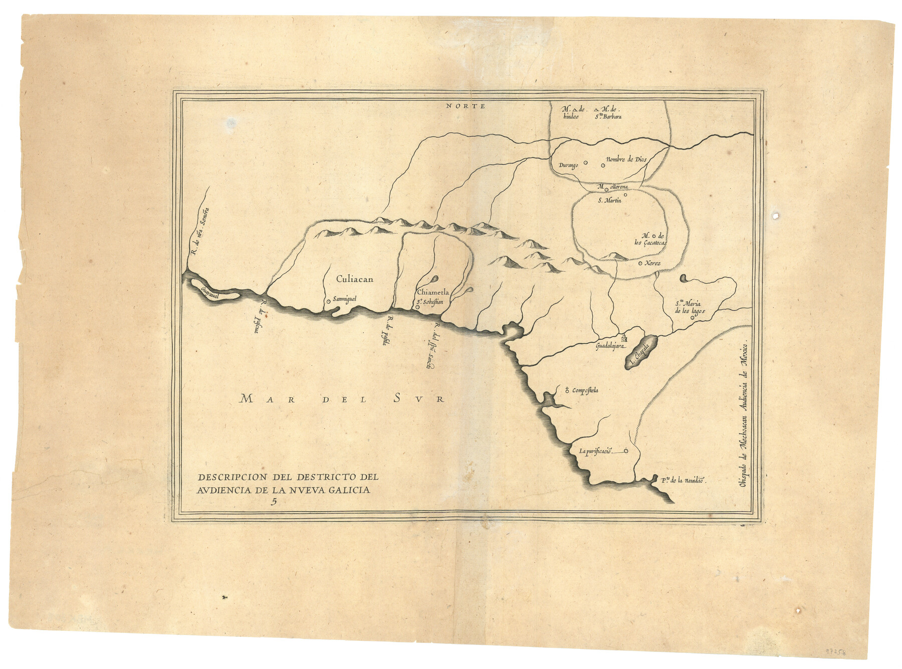
Descripcion del Destricto del Audiencia de la Nueva Galicia
-
Map/Doc
97258
-
Collection
General Map Collection
-
Object Dates
[1622] (Creation Date)
-
People and Organizations
Antonio de Herrera y Tordesillas (Cartographer)
-
Subjects
Mexico
-
Height x Width
13.0 x 17.6 inches
33.0 x 44.7 cm
Part of: General Map Collection
Pecos County Working Sketch 78

Print $20.00
- Digital $50.00
Pecos County Working Sketch 78
Size 29.4 x 34.4 inches
Map/Doc 71550
Clay County Sketch File 24a

Print $7.00
- Digital $50.00
Clay County Sketch File 24a
1881
Size 11.0 x 8.7 inches
Map/Doc 18439
Hutchinson County Sketch File 15

Print $20.00
- Digital $50.00
Hutchinson County Sketch File 15
Size 20.7 x 26.7 inches
Map/Doc 11813
Hardin County

Print $20.00
- Digital $50.00
Hardin County
1940
Size 47.4 x 42.4 inches
Map/Doc 73171
Runnels County Working Sketch 17

Print $4.00
- Digital $50.00
Runnels County Working Sketch 17
Size 27.1 x 21.5 inches
Map/Doc 63613
Newton County Rolled Sketch 7

Print $20.00
- Digital $50.00
Newton County Rolled Sketch 7
1943
Size 21.4 x 37.2 inches
Map/Doc 6843
Midland County Rolled Sketch 5

Print $20.00
- Digital $50.00
Midland County Rolled Sketch 5
Size 35.3 x 44.8 inches
Map/Doc 10695
Kerr County Working Sketch 1

Print $20.00
- Digital $50.00
Kerr County Working Sketch 1
Size 18.5 x 18.0 inches
Map/Doc 70032
Motley County Sketch File 16 (N)

Print $16.00
- Digital $50.00
Motley County Sketch File 16 (N)
1911
Size 11.0 x 8.6 inches
Map/Doc 32052
Taylor County Sketch File 11

Print $20.00
- Digital $50.00
Taylor County Sketch File 11
Size 34.8 x 28.3 inches
Map/Doc 10384
Foard County Sketch File 12

Print $4.00
- Digital $50.00
Foard County Sketch File 12
1881
Size 11.0 x 8.5 inches
Map/Doc 22814
Victoria County Sketch File 1

Print $20.00
- Digital $50.00
Victoria County Sketch File 1
1853
Size 12.9 x 17.3 inches
Map/Doc 12595
You may also like
Real County Working Sketch 72

Print $20.00
- Digital $50.00
Real County Working Sketch 72
Size 47.3 x 43.3 inches
Map/Doc 71964
Harrison County Sketch File 15

Print $20.00
- Digital $50.00
Harrison County Sketch File 15
Size 23.2 x 23.0 inches
Map/Doc 11690
[Area along North line of McLennan County School Land]
![90928, [Area along North line of McLennan County School Land], Twichell Survey Records](https://historictexasmaps.com/wmedia_w700/maps/90928-1.tif.jpg)
Print $2.00
- Digital $50.00
[Area along North line of McLennan County School Land]
1920
Size 5.5 x 14.9 inches
Map/Doc 90928
Letter from Jesse Grimes Suggesting a Redefinition of the Boundary Between Harris and Montgomery Counties, April 30, 1838

Print $20.00
- Digital $50.00
Letter from Jesse Grimes Suggesting a Redefinition of the Boundary Between Harris and Montgomery Counties, April 30, 1838
2020
Size 7.7 x 10.8 inches
Map/Doc 96381
Live Oak County Working Sketch 33

Print $6.00
- Digital $50.00
Live Oak County Working Sketch 33
Size 25.9 x 35.1 inches
Map/Doc 70618
Medina County

Print $40.00
- Digital $50.00
Medina County
1915
Size 50.0 x 42.0 inches
Map/Doc 66925
Wichita County Working Sketch 25

Print $20.00
- Digital $50.00
Wichita County Working Sketch 25
Size 27.1 x 27.7 inches
Map/Doc 72535
Flight Mission No. DCL-7C, Frame 44, Kenedy County

Print $20.00
- Digital $50.00
Flight Mission No. DCL-7C, Frame 44, Kenedy County
1943
Size 15.4 x 15.2 inches
Map/Doc 86032
Reeves County Sketch File 28

Print $12.00
- Digital $50.00
Reeves County Sketch File 28
2003
Size 14.3 x 8.8 inches
Map/Doc 78496
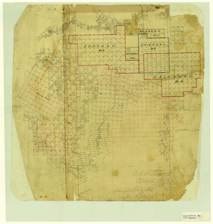
Edwards County Rolled Sketch 7
Print $20.00
- Digital $50.00
Edwards County Rolled Sketch 7
1881
Size 24.4 x 23.2 inches
Map/Doc 5800
Stephens County Working Sketch 35

Print $20.00
- Digital $50.00
Stephens County Working Sketch 35
Size 14.5 x 26.0 inches
Map/Doc 63978
Atascosa County Sketch File 27c

Print $12.00
- Digital $50.00
Atascosa County Sketch File 27c
1876
Size 12.7 x 8.4 inches
Map/Doc 13806