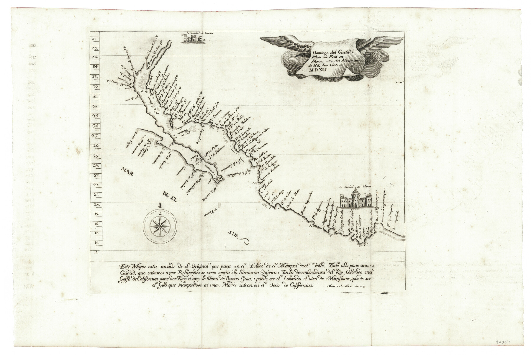
[Untitled Map of Baja California & West Coast of Mexico]
-
Map/Doc
97353
-
Collection
General Map Collection
-
Object Dates
1541 (Creation Date)
1770 (Reproduction Date)
-
People and Organizations
Domingo del Castillo (Cartographer)
-
Subjects
Mexico
-
Height x Width
11.1 x 16.7 inches
28.2 x 42.4 cm
-
Comments
This map was attached to the volume: "Historia de Nueva-España" (97351). It is a 1770 reproduction of Domingo del Castillo's manuscript map of 1541.
Related maps
Historia de Nueva-España, escrita por su esclarecido conquistador Hernan Cortes, aumentada con otros documentos, y notas, por el ilustrissimo señor don Francisco Antonio Lorenzana, Arzobispo de Mexico

Historia de Nueva-España, escrita por su esclarecido conquistador Hernan Cortes, aumentada con otros documentos, y notas, por el ilustrissimo señor don Francisco Antonio Lorenzana, Arzobispo de Mexico
1770
Map/Doc 97351
Part of: General Map Collection
Colorado River, Danevang Sheet

Print $6.00
- Digital $50.00
Colorado River, Danevang Sheet
1940
Size 24.6 x 35.2 inches
Map/Doc 65321
[Surveys along the Leon River]
![20, [Surveys along the Leon River], General Map Collection](https://historictexasmaps.com/wmedia_w700/maps/20-1.tif.jpg)
Print $20.00
- Digital $50.00
[Surveys along the Leon River]
1840
Size 20.3 x 6.6 inches
Map/Doc 20
Karnes County Rolled Sketch 4

Print $20.00
- Digital $50.00
Karnes County Rolled Sketch 4
1961
Size 33.4 x 37.7 inches
Map/Doc 9667

Flight Mission No. DQO-8K, Frame 88, Galveston County

Print $20.00
- Digital $50.00
Flight Mission No. DQO-8K, Frame 88, Galveston County
1952
Size 18.7 x 22.4 inches
Map/Doc 85190
Part of the boundary between the United States and Texas: north of Sabine River from the 72nd mile mound to Red River (C.2)

Print $2.00
- Digital $50.00
Part of the boundary between the United States and Texas: north of Sabine River from the 72nd mile mound to Red River (C.2)
1842
Size 12.8 x 8.3 inches
Map/Doc 65385
Acreage in Texas by Counties

Acreage in Texas by Counties
1983
Size 10.3 x 11.8 inches
Map/Doc 97033
Cooke County Working Sketch 14

Print $40.00
- Digital $50.00
Cooke County Working Sketch 14
1944
Size 34.1 x 49.7 inches
Map/Doc 68251
Hardeman County Sketch File 29

Print $20.00
- Digital $50.00
Hardeman County Sketch File 29
1890
Size 12.9 x 8.2 inches
Map/Doc 25056
Goliad County Sketch File 23

Print $4.00
- Digital $50.00
Goliad County Sketch File 23
1877
Size 8.1 x 12.8 inches
Map/Doc 24295
Knox County Sketch File 29

Print $20.00
- Digital $50.00
Knox County Sketch File 29
Size 18.6 x 36.1 inches
Map/Doc 11965
You may also like
Williamson County Working Sketch Graphic Index

Print $40.00
- Digital $50.00
Williamson County Working Sketch Graphic Index
1946
Size 38.4 x 55.7 inches
Map/Doc 76742
Floyd County Rolled Sketch 9

Print $323.00
- Digital $50.00
Floyd County Rolled Sketch 9
1953
Size 10.0 x 15.7 inches
Map/Doc 44564
Upton County Rolled Sketch 59
Print $40.00
- Digital $50.00
Upton County Rolled Sketch 59
Size 36.3 x 49.0 inches
Map/Doc 10638
Oldham County Sketch File 14

Print $20.00
- Digital $50.00
Oldham County Sketch File 14
1904
Size 20.0 x 24.6 inches
Map/Doc 12115
General Highway Map, Nueces County, Texas

Print $20.00
General Highway Map, Nueces County, Texas
1961
Size 24.9 x 18.4 inches
Map/Doc 79615
Nueces County Sketch File 28

Print $6.00
- Digital $50.00
Nueces County Sketch File 28
Size 10.0 x 10.9 inches
Map/Doc 32596
Zavala County Sketch File 7

Print $6.00
- Digital $50.00
Zavala County Sketch File 7
Size 9.4 x 16.3 inches
Map/Doc 41265
[G. C. & S. F. Ry., San Saba Branch, Right of Way Map, Brady to Melvin]
![61421, [G. C. & S. F. Ry., San Saba Branch, Right of Way Map, Brady to Melvin], General Map Collection](https://historictexasmaps.com/wmedia_w700/maps/61421.tif.jpg)
Print $40.00
- Digital $50.00
[G. C. & S. F. Ry., San Saba Branch, Right of Way Map, Brady to Melvin]
1916
Size 37.7 x 121.5 inches
Map/Doc 61421
[Surveys along the Nueces River, San Patricio District]
![69739, [Surveys along the Nueces River, San Patricio District], General Map Collection](https://historictexasmaps.com/wmedia_w700/maps/69739.tif.jpg)
Print $2.00
- Digital $50.00
[Surveys along the Nueces River, San Patricio District]
1842
Size 11.3 x 7.7 inches
Map/Doc 69739
Dallas County Sketch File 10

Print $4.00
- Digital $50.00
Dallas County Sketch File 10
1858
Size 12.5 x 8.2 inches
Map/Doc 20414
Childress County Sketch File 2

Print $24.00
- Digital $50.00
Childress County Sketch File 2
Size 6.5 x 16.1 inches
Map/Doc 18244