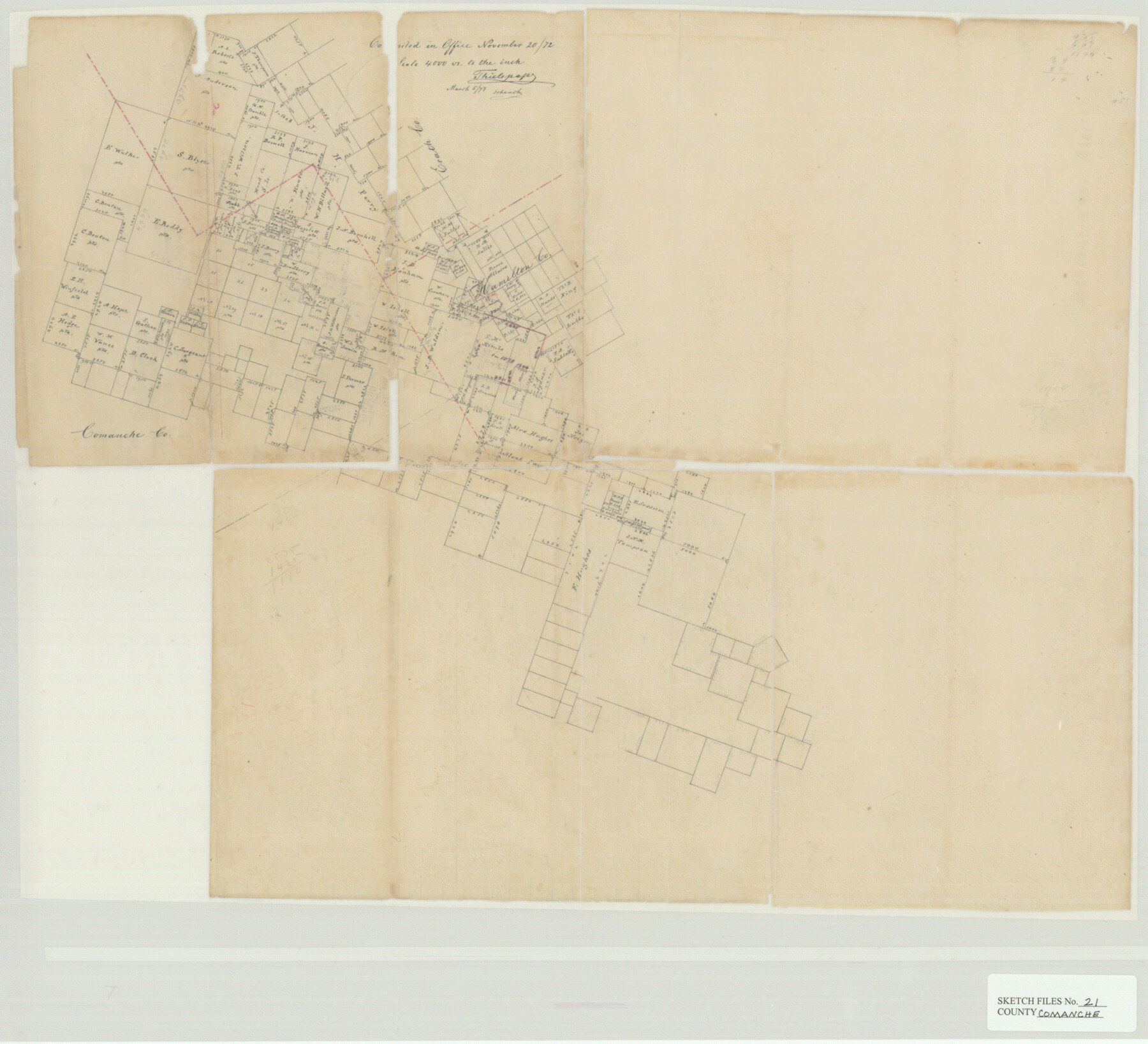
Comanche County Sketch File 21
East corner partly in Hood
- 
                          Map/Doc11143
- 
                            CollectionGeneral Map Collection
- 
                            Object Dates1872/11/20 (File Date)
- 
                            People and OrganizationsThielepape (Draftsman)
- 
                            CountiesComanche Hamilton Erath
- 
                            SubjectsSurveying Sketch File
- 
                            Height x Width18.3 x 20.2 inches46.5 x 51.3 cm
- 
                            Mediumpaper, manuscript
- 
                            Scale1:4000
Part of: General Map Collection
            Bastrop County Sketch File 9


                                            Print $40.00                    
                                             -                         Digital $50.00                                    
                Bastrop County Sketch File 9
1943
Size 46.5 x 20.6 inches
                                Map/Doc 10320
            
            Tarrant County Sketch File 23


                                            Print $4.00                    
                                             -                         Digital $50.00                                    
                Tarrant County Sketch File 23
Size 6.1 x 8.2 inches
                                Map/Doc 37733
            
            Leon County Texas


                                            Print $20.00                    
                                             -                         Digital $50.00                                    
                Leon County Texas
1896
Size 25.4 x 22.1 inches
                                Map/Doc 3806
            
            Presidio County Rolled Sketch 90


                                            Print $20.00                    
                                             -                         Digital $50.00                                    
                Presidio County Rolled Sketch 90
1947
Size 20.5 x 24.4 inches
                                Map/Doc 7375
            
            Sabine County Sketch File 6


                                            Print $6.00                    
                                    
                Sabine County Sketch File 6
Size 3.4 x 5.8 inches
                                Map/Doc 35612
            
            Taylor County Rolled Sketch 30A


                                            Print $20.00                    
                                             -                         Digital $50.00                                    
                Taylor County Rolled Sketch 30A
Size 17.5 x 11.3 inches
                                Map/Doc 76410
            
            PSL Field Notes for Blocks A42 through A55 in Andrews County


            PSL Field Notes for Blocks A42 through A55 in Andrews County
Map/Doc 81644
            
            Tom Green County Sketch File 70


                                            Print $6.00                    
                                             -                         Digital $50.00                                    
                Tom Green County Sketch File 70
1945
Size 11.3 x 8.9 inches
                                Map/Doc 38241
            
            Angelina County Sketch File 15f


                                            Print $4.00                    
                                             -                         Digital $50.00                                    
                Angelina County Sketch File 15f
Size 10.4 x 7.6 inches
                                Map/Doc 12994
            
            Williamson County Sketch File 6


                                            Print $4.00                    
                                             -                         Digital $50.00                                    
                Williamson County Sketch File 6
1848
Size 12.8 x 8.1 inches
                                Map/Doc 40314
            
            J No. 5 - Reconnaissance of San Pedro Harbor, California


                                            Print $20.00                    
                                             -                         Digital $50.00                                    
                J No. 5 - Reconnaissance of San Pedro Harbor, California
1852
Size 12.3 x 15.5 inches
                                Map/Doc 97232
            
            Hardin County Sketch File 31


                                            Print $2.00                    
                                             -                         Digital $50.00                                    
                Hardin County Sketch File 31
Size 8.5 x 7.1 inches
                                Map/Doc 25162
            You may also like
            That part of the boundary between the Republic of Texas and the United States, North of Sabine River from the 36th to the 72nd Mile Mound on the Meridian Line (Sheet No. 2)


                                            Print $20.00                    
                                             -                         Digital $50.00                                    
                That part of the boundary between the Republic of Texas and the United States, North of Sabine River from the 36th to the 72nd Mile Mound on the Meridian Line (Sheet No. 2)
1842
Size 33.7 x 26.0 inches
                                Map/Doc 3132
            
            Calhoun County Sketch File 15


                                            Print $40.00                    
                                             -                         Digital $50.00                                    
                Calhoun County Sketch File 15
1929
Size 36.8 x 25.4 inches
                                Map/Doc 11036
            
            Coryell County Working Sketch 17


                                            Print $20.00                    
                                             -                         Digital $50.00                                    
                Coryell County Working Sketch 17
1958
Size 35.4 x 35.0 inches
                                Map/Doc 68224
            
            McLennan County Working Sketch 9


                                            Print $20.00                    
                                             -                         Digital $50.00                                    
                McLennan County Working Sketch 9
2008
Size 23.0 x 28.9 inches
                                Map/Doc 88768
            
            Flight Mission No. CGI-1N, Frame 172, Cameron County


                                            Print $20.00                    
                                             -                         Digital $50.00                                    
                Flight Mission No. CGI-1N, Frame 172, Cameron County
1955
Size 18.5 x 22.2 inches
                                Map/Doc 84507
            
            Starr County Working Sketch 8


                                            Print $20.00                    
                                             -                         Digital $50.00                                    
                Starr County Working Sketch 8
1939
Size 21.9 x 28.8 inches
                                Map/Doc 63924
            
            Bee County Sketch File 31


                                            Print $6.00                    
                                             -                         Digital $50.00                                    
                Bee County Sketch File 31
1886
Size 12.8 x 8.2 inches
                                Map/Doc 14344
            
            Cooke County Sketch File 27


                                            Print $24.00                    
                                             -                         Digital $50.00                                    
                Cooke County Sketch File 27
Size 9.8 x 8.5 inches
                                Map/Doc 19279
            
            [Northern Bexar District]
            
                                    ![1963, [Northern Bexar District], General Map Collection](https://historictexasmaps.com/wmedia_w700/maps/1963-1.tif.jpg) 


    ![1963, [Northern Bexar District], General Map Collection](https://historictexasmaps.com/wmedia_w700/maps/1963-1.tif.jpg) 
                                
            
                                            Print $20.00                    
                                             -                         Digital $50.00                                    
                [Northern Bexar District]
1852
Size 46.0 x 26.5 inches
                                Map/Doc 1963
            
            Lynn County Boundary File 6a


                                            Print $2.00                    
                                             -                         Digital $50.00                                    
                Lynn County Boundary File 6a
Size 11.2 x 8.7 inches
                                Map/Doc 56641
             
                             
                                