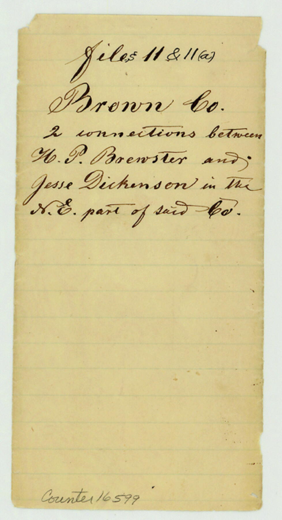
Brown County Sketch File 11a
[Connection between H.P. Brewster and Jesse Dickinson surveys in the northeast corner of the county]
-
Map/Doc
16599
-
Collection
General Map Collection
-
Object Dates
1872/1/25 (Creation Date)
1872/2/28 (File Date)
-
People and Organizations
R.G. Armstrong (Surveyor/Engineer)
-
Counties
Brown
-
Subjects
Surveying Sketch File
-
Height x Width
6.6 x 3.6 inches
16.8 x 9.1 cm
-
Medium
paper, manuscript
Part of: General Map Collection
Hunt County Rolled Sketch 5

Print $20.00
- Digital $50.00
Hunt County Rolled Sketch 5
1956
Size 28.6 x 24.3 inches
Map/Doc 6268
Atascosa County Rolled Sketch 25

Print $20.00
- Digital $50.00
Atascosa County Rolled Sketch 25
Size 25.2 x 20.5 inches
Map/Doc 93551
Flight Mission No. DQO-3K, Frame 20, Galveston County

Print $20.00
- Digital $50.00
Flight Mission No. DQO-3K, Frame 20, Galveston County
1952
Size 18.8 x 22.6 inches
Map/Doc 85061
Shackelford County Boundary File 7b

Print $90.00
- Digital $50.00
Shackelford County Boundary File 7b
Size 7.9 x 10.4 inches
Map/Doc 58692
Hays County Rolled Sketch 22

Print $20.00
- Digital $50.00
Hays County Rolled Sketch 22
1924
Size 19.4 x 20.6 inches
Map/Doc 6178
Clay County Boundary File 18

Print $12.00
- Digital $50.00
Clay County Boundary File 18
Size 14.2 x 8.5 inches
Map/Doc 51437
Map of Webb County

Print $20.00
- Digital $50.00
Map of Webb County
1895
Size 34.8 x 27.0 inches
Map/Doc 4132
Hutchinson County Rolled Sketch 13

Print $20.00
- Digital $50.00
Hutchinson County Rolled Sketch 13
Size 17.8 x 16.7 inches
Map/Doc 6283
Brewster County Working Sketch 9

Print $20.00
- Digital $50.00
Brewster County Working Sketch 9
1910
Size 14.3 x 14.4 inches
Map/Doc 67542
Houston County Sketch File 7a

Print $4.00
- Digital $50.00
Houston County Sketch File 7a
Size 7.6 x 8.2 inches
Map/Doc 26766
Travis County Rolled Sketch 41

Print $20.00
- Digital $50.00
Travis County Rolled Sketch 41
Size 31.3 x 24.7 inches
Map/Doc 8039
Brewster County Working Sketch 53

Print $20.00
- Digital $50.00
Brewster County Working Sketch 53
1951
Size 32.1 x 16.5 inches
Map/Doc 67587
You may also like
Wichita County Rolled Sketch 19

Print $20.00
- Digital $50.00
Wichita County Rolled Sketch 19
1963
Size 28.5 x 30.9 inches
Map/Doc 8255
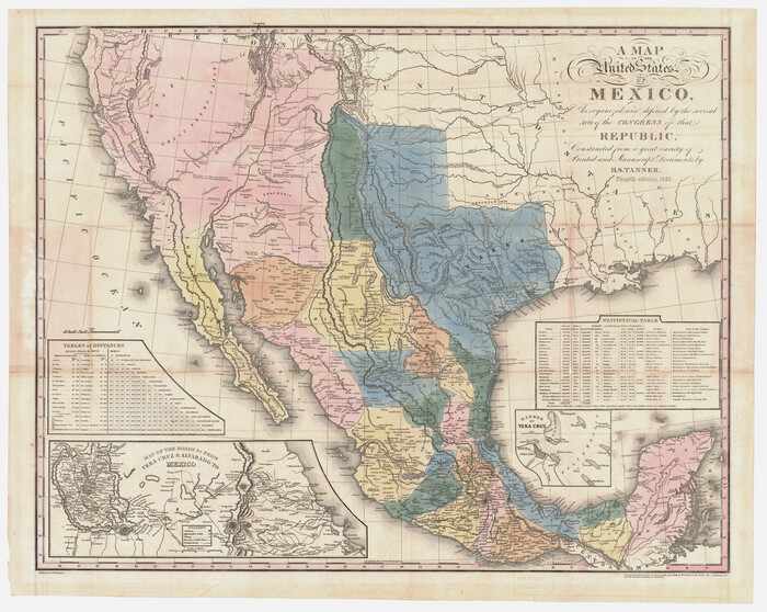
A Map of the United States of Mexico as organized and defined by the several Acts of the Congress of that Republic
Print $20.00
- Digital $50.00
A Map of the United States of Mexico as organized and defined by the several Acts of the Congress of that Republic
1847
Size 25.3 x 31.8 inches
Map/Doc 95913
Amistad International Reservoir on Rio Grande 68a

Print $20.00
- Digital $50.00
Amistad International Reservoir on Rio Grande 68a
1949
Size 28.4 x 39.6 inches
Map/Doc 73354
Fort Bend County Working Sketch 3

Print $20.00
- Digital $50.00
Fort Bend County Working Sketch 3
1897
Size 26.8 x 24.6 inches
Map/Doc 69209

Hudspeth County Working Sketch 16

Print $40.00
- Digital $50.00
Hudspeth County Working Sketch 16
1957
Size 21.1 x 71.2 inches
Map/Doc 66298
Borden County Sketch File 2

Print $40.00
- Digital $50.00
Borden County Sketch File 2
Size 19.4 x 10.3 inches
Map/Doc 10932
[Sketch showing B. S. & F. Block 9 and vicinity]
![89786, [Sketch showing B. S. & F. Block 9 and vicinity], Twichell Survey Records](https://historictexasmaps.com/wmedia_w700/maps/89786-1.tif.jpg)
Print $20.00
- Digital $50.00
[Sketch showing B. S. & F. Block 9 and vicinity]
Size 39.0 x 47.6 inches
Map/Doc 89786
Schleicher County Rolled Sketch 24

Print $20.00
- Digital $50.00
Schleicher County Rolled Sketch 24
Size 29.1 x 15.9 inches
Map/Doc 7763
Map of Presidio County

Print $40.00
- Digital $50.00
Map of Presidio County
1895
Size 53.0 x 38.6 inches
Map/Doc 3968
Ector County Working Sketch Graphic Index - sheet B

Print $20.00
- Digital $50.00
Ector County Working Sketch Graphic Index - sheet B
1943
Size 43.9 x 37.7 inches
Map/Doc 76531
Haskell County Sketch File 20

Print $20.00
- Digital $50.00
Haskell County Sketch File 20
1902
Size 20.9 x 26.2 inches
Map/Doc 11743