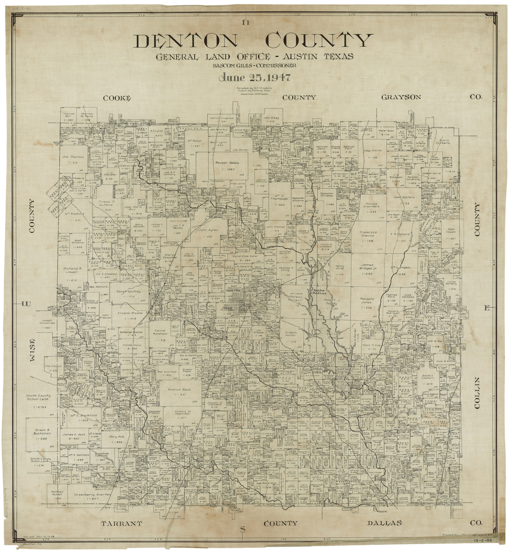
Denton County
RM-2-61
-
Map/Doc
1817
-
Collection
General Map Collection
-
Object Dates
6/25/1947 (Creation Date)
-
People and Organizations
Texas General Land Office (Publisher)
Bascom Giles (GLO Commissioner)
Tommye Buie (Draftsman)
R.C. Wisdom (Compiler)
-
Counties
Denton
-
Subjects
County
-
Height x Width
42.1 x 38.6 inches
106.9 x 98.0 cm
-
Comments
Traced March 19, 1948 by Gladys Adams.
Part of: General Map Collection
Harris County Working Sketch 69

Print $20.00
- Digital $50.00
Harris County Working Sketch 69
1956
Size 32.7 x 28.2 inches
Map/Doc 65961
Pecos County Working Sketch 132

Print $40.00
- Digital $50.00
Pecos County Working Sketch 132
1979
Size 34.6 x 49.3 inches
Map/Doc 71606
Flight Mission No. DQO-8K, Frame 46, Galveston County

Print $20.00
- Digital $50.00
Flight Mission No. DQO-8K, Frame 46, Galveston County
1952
Size 18.7 x 22.4 inches
Map/Doc 85153
Flight Mission No. BQY-15M, Frame 18, Harris County

Print $20.00
- Digital $50.00
Flight Mission No. BQY-15M, Frame 18, Harris County
1953
Size 18.6 x 22.5 inches
Map/Doc 85316
Crockett County Rolled Sketch S

Print $20.00
- Digital $50.00
Crockett County Rolled Sketch S
Size 8.3 x 21.2 inches
Map/Doc 5639
Flight Mission No. CUG-3P, Frame 13, Kleberg County

Print $20.00
- Digital $50.00
Flight Mission No. CUG-3P, Frame 13, Kleberg County
1956
Size 18.6 x 22.1 inches
Map/Doc 86223
Flight Mission No. DQO-2K, Frame 97, Galveston County

Print $20.00
- Digital $50.00
Flight Mission No. DQO-2K, Frame 97, Galveston County
1952
Size 18.7 x 22.5 inches
Map/Doc 85024
Rio Grande, Willamar Sheet

Print $20.00
- Digital $50.00
Rio Grande, Willamar Sheet
1937
Size 36.9 x 37.2 inches
Map/Doc 65111
La Salle County Working Sketch 7

Print $20.00
- Digital $50.00
La Salle County Working Sketch 7
1922
Size 35.0 x 36.5 inches
Map/Doc 70308
Matagorda County Working Sketch 33

Print $20.00
- Digital $50.00
Matagorda County Working Sketch 33
1998
Size 32.0 x 42.5 inches
Map/Doc 70891
Flight Mission No. BQR-9K, Frame 10, Brazoria County

Print $20.00
- Digital $50.00
Flight Mission No. BQR-9K, Frame 10, Brazoria County
1952
Size 18.7 x 22.3 inches
Map/Doc 84039
Hardin County Sketch File 44

Print $6.00
- Digital $50.00
Hardin County Sketch File 44
Size 6.7 x 7.4 inches
Map/Doc 25192
You may also like
Trinity River, Bazzette Sheet

Print $4.00
- Digital $50.00
Trinity River, Bazzette Sheet
1925
Size 28.2 x 24.9 inches
Map/Doc 65218
Flight Mission No. CRC-3R, Frame 8, Chambers County

Print $20.00
- Digital $50.00
Flight Mission No. CRC-3R, Frame 8, Chambers County
1956
Size 18.6 x 22.2 inches
Map/Doc 84782
Real County Working Sketch 43

Print $20.00
- Digital $50.00
Real County Working Sketch 43
1953
Size 32.4 x 30.5 inches
Map/Doc 71935
Crosby County Sketch File 15a

Print $20.00
- Digital $50.00
Crosby County Sketch File 15a
1907
Size 37.6 x 41.1 inches
Map/Doc 10352
Yellowhouse Land Company's Subdivision of Spade Ranch Lands Situated in Lamb and Hockley Counties, Texas

Print $20.00
- Digital $50.00
Yellowhouse Land Company's Subdivision of Spade Ranch Lands Situated in Lamb and Hockley Counties, Texas
Size 21.5 x 22.5 inches
Map/Doc 92228
Presidio County Sketch File 32

Print $8.00
- Digital $50.00
Presidio County Sketch File 32
1885
Size 11.2 x 8.7 inches
Map/Doc 34472
Parker County Sketch File D

Print $4.00
- Digital $50.00
Parker County Sketch File D
Size 9.9 x 8.2 inches
Map/Doc 33514
[Right of Way & Track Map, The Texas & Pacific Ry. Co. Main Line]
![64689, [Right of Way & Track Map, The Texas & Pacific Ry. Co. Main Line], General Map Collection](https://historictexasmaps.com/wmedia_w700/maps/64689.tif.jpg)
Print $20.00
- Digital $50.00
[Right of Way & Track Map, The Texas & Pacific Ry. Co. Main Line]
Size 11.0 x 19.0 inches
Map/Doc 64689
General Highway Map, Wheeler County, Texas

Print $20.00
General Highway Map, Wheeler County, Texas
1961
Size 18.1 x 24.9 inches
Map/Doc 79708
General Highway Map, Medina County, Texas

Print $20.00
General Highway Map, Medina County, Texas
1940
Size 18.3 x 24.5 inches
Map/Doc 79194
Matagorda County NRC Article 33.136 Sketch 16

Digital $50.00
Matagorda County NRC Article 33.136 Sketch 16
2023
Map/Doc 97256
Webb County Working Sketch 2

Print $20.00
- Digital $50.00
Webb County Working Sketch 2
1906
Size 11.2 x 12.5 inches
Map/Doc 72367