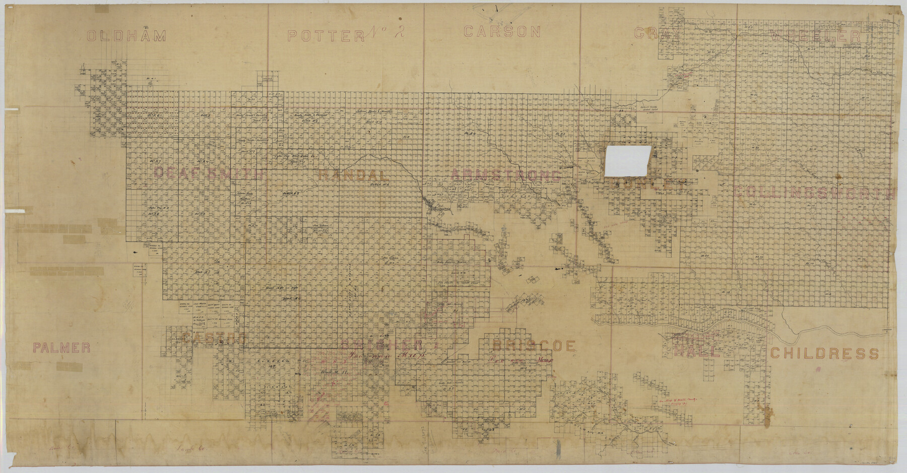
District Map Showing Deaf Smith, Randall, Armstrong, Donley, Collingsworth, Castro, Swisher, Briscoe, Hall & Childress Counties, Texas
Jack District Map Number 3
N-2-62
-
Map/Doc
1994
-
Collection
General Map Collection
-
Object Dates
1878 (Creation Date)
-
People and Organizations
General Land Office (Publisher)
-
Counties
Deaf Smith Randall Armstrong Donley
-
Subjects
District
-
Height x Width
42.9 x 82.3 inches
109.0 x 209.0 cm
-
Comments
District map of what is now Deaf Smith, Randall, Armstrong, Donley, Collingsworth, Castro, Swisher, Briscoe, Hall, and Childress Counties.
Part of: General Map Collection
Liberty County Working Sketch 40

Print $20.00
- Digital $50.00
Liberty County Working Sketch 40
1952
Size 24.1 x 32.9 inches
Map/Doc 70499
Glasscock County Sketch File 1

Print $46.00
- Digital $50.00
Glasscock County Sketch File 1
Size 26.1 x 31.8 inches
Map/Doc 11558
Duval County Working Sketch 45

Print $20.00
- Digital $50.00
Duval County Working Sketch 45
1979
Size 29.7 x 30.8 inches
Map/Doc 68769
Marion County Working Sketch 17

Print $20.00
- Digital $50.00
Marion County Working Sketch 17
1955
Size 31.1 x 26.1 inches
Map/Doc 70793
Caldwell County Working Sketch 12

Print $20.00
- Digital $50.00
Caldwell County Working Sketch 12
1979
Size 47.7 x 44.2 inches
Map/Doc 67842
Kerr County Working Sketch 7

Print $20.00
- Digital $50.00
Kerr County Working Sketch 7
1947
Size 38.9 x 30.8 inches
Map/Doc 70038
Brewster County Sketch File S-29

Print $44.00
- Digital $50.00
Brewster County Sketch File S-29
1971
Size 11.1 x 8.7 inches
Map/Doc 15846
Travis County Sketch File 43

Print $30.00
- Digital $50.00
Travis County Sketch File 43
1887
Size 8.8 x 9.3 inches
Map/Doc 38359
Flight Mission No. CRC-3R, Frame 20, Chambers County

Print $20.00
- Digital $50.00
Flight Mission No. CRC-3R, Frame 20, Chambers County
1956
Size 18.6 x 22.2 inches
Map/Doc 84794
Runnels County Rolled Sketch 41

Print $20.00
- Digital $50.00
Runnels County Rolled Sketch 41
Size 26.1 x 29.8 inches
Map/Doc 7529
Tarrant County Working Sketch 23

Print $20.00
- Digital $50.00
Tarrant County Working Sketch 23
2001
Size 15.9 x 15.6 inches
Map/Doc 62440
Nueces County Rolled Sketch 27B

Print $108.00
- Digital $50.00
Nueces County Rolled Sketch 27B
1948
Size 9.8 x 15.1 inches
Map/Doc 47604
You may also like
Map showing resurvey of Capitol Leagues, Oldham Co., Texas

Print $40.00
- Digital $50.00
Map showing resurvey of Capitol Leagues, Oldham Co., Texas
1918
Size 38.6 x 51.0 inches
Map/Doc 1755
Milam County Working Sketch 14

Print $20.00
- Digital $50.00
Milam County Working Sketch 14
1904
Size 28.2 x 16.7 inches
Map/Doc 71029
Motley County

Print $20.00
- Digital $50.00
Motley County
1966
Size 43.8 x 34.8 inches
Map/Doc 73247
Travis County Working Sketch 1

Print $20.00
- Digital $50.00
Travis County Working Sketch 1
Size 30.9 x 17.6 inches
Map/Doc 69385
El Paso County Working Sketch 41

Print $20.00
- Digital $50.00
El Paso County Working Sketch 41
1985
Size 30.3 x 31.6 inches
Map/Doc 69063
Comal County Working Sketch 2

Print $20.00
- Digital $50.00
Comal County Working Sketch 2
1940
Size 19.8 x 20.9 inches
Map/Doc 68168
Dimmit County Working Sketch 17

Print $20.00
- Digital $50.00
Dimmit County Working Sketch 17
1943
Size 27.4 x 24.7 inches
Map/Doc 68678
Duval County Rolled Sketch GEB

Print $20.00
- Digital $50.00
Duval County Rolled Sketch GEB
1935
Size 26.9 x 30.4 inches
Map/Doc 5768
Plat of Common Line of Baylor and Throckmorton Counties as Run by A.D. Kerr and F.B. Stribling

Print $40.00
- Digital $50.00
Plat of Common Line of Baylor and Throckmorton Counties as Run by A.D. Kerr and F.B. Stribling
Size 63.0 x 9.0 inches
Map/Doc 89640
Reeves County Working Sketch 43

Print $20.00
- Digital $50.00
Reeves County Working Sketch 43
1974
Size 43.2 x 37.1 inches
Map/Doc 63486
Old Miscellaneous File 23

Print $58.00
- Digital $50.00
Old Miscellaneous File 23
1919
Size 14.2 x 8.6 inches
Map/Doc 75600
Montgomery County Working Sketch 56

Print $20.00
- Digital $50.00
Montgomery County Working Sketch 56
1961
Size 21.2 x 24.0 inches
Map/Doc 71163