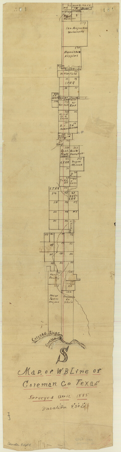
Coleman County Boundary File 17 (3)
[Fieldnotes of the West Boundary line of Coleman County and East Boundary line of Runnels County]
-
Map/Doc
51654
-
Collection
General Map Collection
-
Counties
Coleman
-
Subjects
County Boundaries
-
Height x Width
22.0 x 5.9 inches
55.9 x 15.0 cm
Part of: General Map Collection
Flight Mission No. CGI-3N, Frame 135, Cameron County

Print $20.00
- Digital $50.00
Flight Mission No. CGI-3N, Frame 135, Cameron County
1954
Size 18.7 x 22.1 inches
Map/Doc 84608
Webb County Working Sketch 90

Print $20.00
- Digital $50.00
Webb County Working Sketch 90
1982
Size 26.9 x 25.5 inches
Map/Doc 72457
Upshur County Working Sketch 16, revised

Print $20.00
- Digital $50.00
Upshur County Working Sketch 16, revised
1997
Size 42.9 x 37.2 inches
Map/Doc 69574
Newton County Sketch File 8

Print $4.00
- Digital $50.00
Newton County Sketch File 8
Size 11.0 x 9.0 inches
Map/Doc 32376
Reeves County Rolled Sketch P

Print $20.00
- Digital $50.00
Reeves County Rolled Sketch P
Size 33.2 x 29.2 inches
Map/Doc 9847
Ward County Sketch File 12

Print $4.00
- Digital $50.00
Ward County Sketch File 12
Size 14.3 x 8.8 inches
Map/Doc 39638
Sterling County Working Sketch 2

Print $20.00
- Digital $50.00
Sterling County Working Sketch 2
1941
Size 19.9 x 26.2 inches
Map/Doc 63984
Sketch of a portion of the Texas Coast showing the relative positions of different harbours with the interior Military Posts, and the roads communicating with them, also two new routes from Black Point and Lamar to San Antonio

Print $20.00
- Digital $50.00
Sketch of a portion of the Texas Coast showing the relative positions of different harbours with the interior Military Posts, and the roads communicating with them, also two new routes from Black Point and Lamar to San Antonio
1855
Size 27.3 x 18.3 inches
Map/Doc 72710
Galveston County Sketch File 40

Print $18.00
- Digital $50.00
Galveston County Sketch File 40
1937
Size 14.3 x 8.8 inches
Map/Doc 23442
Tarrant County Sketch File 17

Print $8.00
- Digital $50.00
Tarrant County Sketch File 17
1860
Size 8.3 x 8.1 inches
Map/Doc 37716
[Sketch for Mineral Application 33721 - 33725 Incl. - Padre and Mustang Island]
![2876, [Sketch for Mineral Application 33721 - 33725 Incl. - Padre and Mustang Island], General Map Collection](https://historictexasmaps.com/wmedia_w700/maps/2876.tif.jpg)
Print $20.00
- Digital $50.00
[Sketch for Mineral Application 33721 - 33725 Incl. - Padre and Mustang Island]
1942
Size 29.1 x 23.0 inches
Map/Doc 2876
Webb County Rolled Sketch 46

Print $20.00
- Digital $50.00
Webb County Rolled Sketch 46
1942
Size 25.8 x 27.6 inches
Map/Doc 8202
You may also like
Duval County Working Sketch 14

Print $20.00
- Digital $50.00
Duval County Working Sketch 14
1938
Size 15.2 x 17.7 inches
Map/Doc 68727
Kinney County Working Sketch 44

Print $20.00
- Digital $50.00
Kinney County Working Sketch 44
1978
Size 36.7 x 25.8 inches
Map/Doc 70226
Real County Sketch File 18

Print $28.00
- Digital $50.00
Real County Sketch File 18
1964
Size 14.3 x 8.9 inches
Map/Doc 35076
Coryell County Sketch File 26

Print $10.00
- Digital $50.00
Coryell County Sketch File 26
1951
Size 11.1 x 8.5 inches
Map/Doc 19393
Llano Station Map, Houston & Texas Central R.R. operated by the T. & N. O. R.R. Co.

Print $40.00
- Digital $50.00
Llano Station Map, Houston & Texas Central R.R. operated by the T. & N. O. R.R. Co.
1918
Size 25.8 x 57.1 inches
Map/Doc 64559
Texas since 1850

Print $20.00
- Digital $50.00
Texas since 1850
1897
Size 13.3 x 15.5 inches
Map/Doc 93413
[Sketch highlighting Bob Reid and Fred Turner surveys]
![91692, [Sketch highlighting Bob Reid and Fred Turner surveys], Twichell Survey Records](https://historictexasmaps.com/wmedia_w700/maps/91692-1.tif.jpg)
Print $2.00
- Digital $50.00
[Sketch highlighting Bob Reid and Fred Turner surveys]
Size 5.9 x 7.6 inches
Map/Doc 91692
Flight Mission No. DQN-1K, Frame 122, Calhoun County

Print $20.00
- Digital $50.00
Flight Mission No. DQN-1K, Frame 122, Calhoun County
1953
Size 18.5 x 22.2 inches
Map/Doc 84188
Newton County Working Sketch 3

Print $20.00
- Digital $50.00
Newton County Working Sketch 3
1924
Size 18.2 x 20.6 inches
Map/Doc 71249


Coleman County Boundary File 17 (3)

Print $36.00
- Digital $50.00
Coleman County Boundary File 17 (3)
Size 22.0 x 5.9 inches
Map/Doc 51654