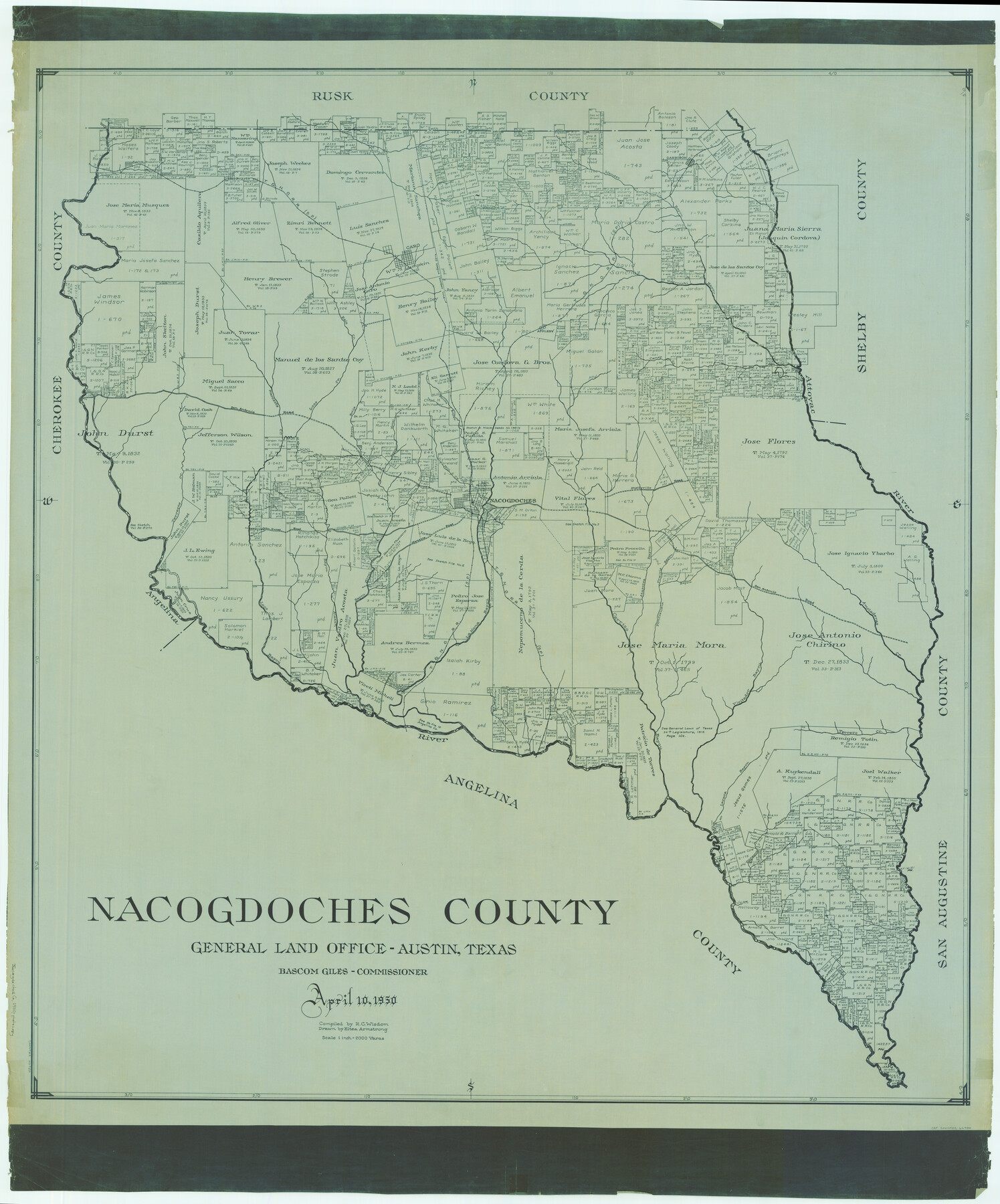
Nacogdoches County
-
Map/Doc
66950
-
Collection
General Map Collection
-
Object Dates
1950/4/10 (Creation Date)
-
People and Organizations
Texas General Land Office (Publisher)
Bascom Giles (GLO Commissioner)
Eltea Armstrong (Draftsman)
R.C. Wisdom (Compiler)
-
Counties
Nacogdoches
-
Subjects
County
-
Height x Width
51.0 x 42.4 inches
129.5 x 107.7 cm
Part of: General Map Collection
Kinney County Rolled Sketch 2

Print $20.00
- Digital $50.00
Kinney County Rolled Sketch 2
Size 24.5 x 36.2 inches
Map/Doc 6534
Coryell County Sketch File 22

Print $20.00
- Digital $50.00
Coryell County Sketch File 22
1943
Size 24.8 x 18.2 inches
Map/Doc 11186
[Sketch for Mineral Application 13271- Trinity River]
![65628, [Sketch for Mineral Application 13271- Trinity River], General Map Collection](https://historictexasmaps.com/wmedia_w700/maps/65628.tif.jpg)
Print $40.00
- Digital $50.00
[Sketch for Mineral Application 13271- Trinity River]
1925
Size 63.1 x 22.4 inches
Map/Doc 65628
Presidio County Sketch File 110

Print $12.00
- Digital $50.00
Presidio County Sketch File 110
1886
Size 12.3 x 8.5 inches
Map/Doc 34818
Matagorda County Working Sketch Graphic Index, Sheet 2 (Sketches 17 to Most Recent)

Print $40.00
- Digital $50.00
Matagorda County Working Sketch Graphic Index, Sheet 2 (Sketches 17 to Most Recent)
1920
Size 40.1 x 48.6 inches
Map/Doc 76634
Blanco County Working Sketch 19

Print $20.00
- Digital $50.00
Blanco County Working Sketch 19
1960
Size 24.4 x 29.2 inches
Map/Doc 67379
Presidio County Sketch File 72

Print $6.00
- Digital $50.00
Presidio County Sketch File 72
1943
Size 13.3 x 8.8 inches
Map/Doc 34679
Hemphill County Working Sketch 12

Print $20.00
- Digital $50.00
Hemphill County Working Sketch 12
1967
Size 23.3 x 34.9 inches
Map/Doc 66107
Sutton County Rolled Sketch 47

Print $20.00
- Digital $50.00
Sutton County Rolled Sketch 47
Size 17.0 x 24.3 inches
Map/Doc 7888
Flight Mission No. BRA-16M, Frame 170, Jefferson County

Print $20.00
- Digital $50.00
Flight Mission No. BRA-16M, Frame 170, Jefferson County
1953
Size 18.6 x 22.4 inches
Map/Doc 85768
Montague County Sketch File 5

Print $20.00
- Digital $50.00
Montague County Sketch File 5
1855
Size 13.1 x 20.1 inches
Map/Doc 12105
Willacy County Aerial Photograph Index Sheet 2

Print $20.00
- Digital $50.00
Willacy County Aerial Photograph Index Sheet 2
1940
Size 24.3 x 20.2 inches
Map/Doc 83757
You may also like
Titus County Sketch File 11

Print $4.00
- Digital $50.00
Titus County Sketch File 11
1872
Size 8.2 x 10.1 inches
Map/Doc 38150
Hood County Working Sketch 27

Print $20.00
- Digital $50.00
Hood County Working Sketch 27
1995
Size 24.6 x 38.0 inches
Map/Doc 66221


Kleberg County Rolled Sketch 10-16

Print $20.00
- Digital $50.00
Kleberg County Rolled Sketch 10-16
1952
Size 37.0 x 33.2 inches
Map/Doc 9381
Kenedy County Rolled Sketch 12

Print $20.00
- Digital $50.00
Kenedy County Rolled Sketch 12
1944
Size 34.6 x 41.1 inches
Map/Doc 9333
Flight Mission No. DAG-19K, Frame 65, Matagorda County

Print $20.00
- Digital $50.00
Flight Mission No. DAG-19K, Frame 65, Matagorda County
1952
Size 18.5 x 22.3 inches
Map/Doc 86392
El Paso County Working Sketch 44

Print $20.00
- Digital $50.00
El Paso County Working Sketch 44
1992
Size 25.6 x 25.4 inches
Map/Doc 69066
Map No. 1 - Surveys Located in 1881 as they appear on the ground

Print $20.00
- Digital $50.00
Map No. 1 - Surveys Located in 1881 as they appear on the ground
1881
Size 30.9 x 19.6 inches
Map/Doc 91927
Aransas County Sketch File 14

Print $36.00
- Digital $50.00
Aransas County Sketch File 14
1891
Size 14.0 x 8.5 inches
Map/Doc 13128
Flight Mission No. BRE-1P, Frame 29, Nueces County

Print $20.00
- Digital $50.00
Flight Mission No. BRE-1P, Frame 29, Nueces County
1956
Size 18.4 x 22.5 inches
Map/Doc 86625
Uvalde County Working Sketch 38

Print $20.00
- Digital $50.00
Uvalde County Working Sketch 38
1970
Size 33.3 x 30.8 inches
Map/Doc 72108