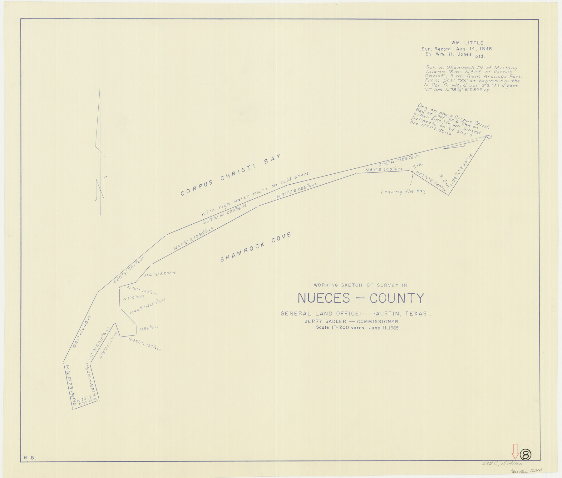
Nueces County Working Sketch 8
-
Map/Doc
71310
-
Collection
General Map Collection
-
Object Dates
6/11/1965 (Creation Date)
-
People and Organizations
Roy Buckholts (Draftsman)
-
Counties
Nueces
-
Subjects
Surveying Working Sketch
-
Height x Width
20.3 x 23.8 inches
51.6 x 60.5 cm
-
Scale
1" = 200 varas
Part of: General Map Collection
Edwards County Sketch File 12b

Print $4.00
- Digital $50.00
Edwards County Sketch File 12b
Size 14.4 x 8.8 inches
Map/Doc 21698
Northwest Part Crockett County

Print $20.00
- Digital $50.00
Northwest Part Crockett County
1983
Size 29.9 x 39.1 inches
Map/Doc 77252
Nueces County Sketch File 30

Print $3.00
- Digital $50.00
Nueces County Sketch File 30
1907
Size 11.4 x 11.9 inches
Map/Doc 32600
Fort Bend County State Real Property Sketch 14

Print $40.00
- Digital $50.00
Fort Bend County State Real Property Sketch 14
1985
Size 36.7 x 35.6 inches
Map/Doc 61688
Wise County Working Sketch 20

Print $20.00
- Digital $50.00
Wise County Working Sketch 20
1979
Size 22.8 x 27.3 inches
Map/Doc 72634
Ellis County Boundary File 1

Print $10.00
- Digital $50.00
Ellis County Boundary File 1
Size 12.5 x 7.7 inches
Map/Doc 52939
[Surveys near Calaveras Creek]
![364, [Surveys near Calaveras Creek], General Map Collection](https://historictexasmaps.com/wmedia_w700/maps/364.tif.jpg)
Print $2.00
- Digital $50.00
[Surveys near Calaveras Creek]
1846
Size 10.9 x 8.0 inches
Map/Doc 364
Gaines County Working Sketch 27

Print $20.00
- Digital $50.00
Gaines County Working Sketch 27
Size 17.4 x 36.7 inches
Map/Doc 69327
Scurry County Boundary File 1

Print $74.00
- Digital $50.00
Scurry County Boundary File 1
Size 9.2 x 3.8 inches
Map/Doc 58597
Karnes County Sketch File 14

Print $6.00
- Digital $50.00
Karnes County Sketch File 14
1897
Size 9.7 x 6.2 inches
Map/Doc 28615
In the Supreme Court of the United States The State of Oklahoma, Complainant vs. The State of Texas, Defendant, The United States of America, Intervener - 1920

Print $20.00
- Digital $50.00
In the Supreme Court of the United States The State of Oklahoma, Complainant vs. The State of Texas, Defendant, The United States of America, Intervener - 1920
1920
Size 31.6 x 37.2 inches
Map/Doc 75115
Harrison County Working Sketch 21

Print $40.00
- Digital $50.00
Harrison County Working Sketch 21
1982
Size 37.6 x 49.9 inches
Map/Doc 66041
You may also like
Jackson County Boundary File 1

Print $24.00
- Digital $50.00
Jackson County Boundary File 1
Size 9.0 x 3.9 inches
Map/Doc 55420
Coleman County Working Sketch 11

Print $20.00
- Digital $50.00
Coleman County Working Sketch 11
1950
Size 24.2 x 18.2 inches
Map/Doc 68077
Flight Mission No. CUG-3P, Frame 22, Kleberg County

Print $20.00
- Digital $50.00
Flight Mission No. CUG-3P, Frame 22, Kleberg County
1956
Size 18.5 x 22.1 inches
Map/Doc 86232
Fayette County Boundary File 7

Print $40.00
- Digital $50.00
Fayette County Boundary File 7
Size 18.1 x 13.1 inches
Map/Doc 53400
Crockett County Rolled Sketch RC1

Print $20.00
- Digital $50.00
Crockett County Rolled Sketch RC1
1935
Size 43.7 x 30.6 inches
Map/Doc 8701
Floyd County Sketch File A

Print $4.00
- Digital $50.00
Floyd County Sketch File A
1893
Size 9.0 x 11.3 inches
Map/Doc 22684
Mason County Sketch File 13

Print $4.00
- Digital $50.00
Mason County Sketch File 13
Size 7.3 x 6.2 inches
Map/Doc 30701
Robertson County Sketch File 12

Print $18.00
Robertson County Sketch File 12
1987
Size 11.4 x 8.8 inches
Map/Doc 35404
Flight Mission No. DAH-10M, Frame 44, Orange County

Print $20.00
- Digital $50.00
Flight Mission No. DAH-10M, Frame 44, Orange County
1953
Size 18.6 x 22.4 inches
Map/Doc 86879
Map of Portion of the Gulf of Mexico Adjoining Jefferson County Showing Subdivision Thereof for Mineral Development

Print $20.00
- Digital $50.00
Map of Portion of the Gulf of Mexico Adjoining Jefferson County Showing Subdivision Thereof for Mineral Development
1940
Size 17.7 x 20.2 inches
Map/Doc 3018
Railroad Track Map, H&TCRRCo., Falls County, Texas

Print $4.00
- Digital $50.00
Railroad Track Map, H&TCRRCo., Falls County, Texas
1918
Size 11.4 x 18.7 inches
Map/Doc 62851
Harris County Rolled Sketch 89

Print $20.00
- Digital $50.00
Harris County Rolled Sketch 89
1899
Size 22.1 x 35.3 inches
Map/Doc 6128