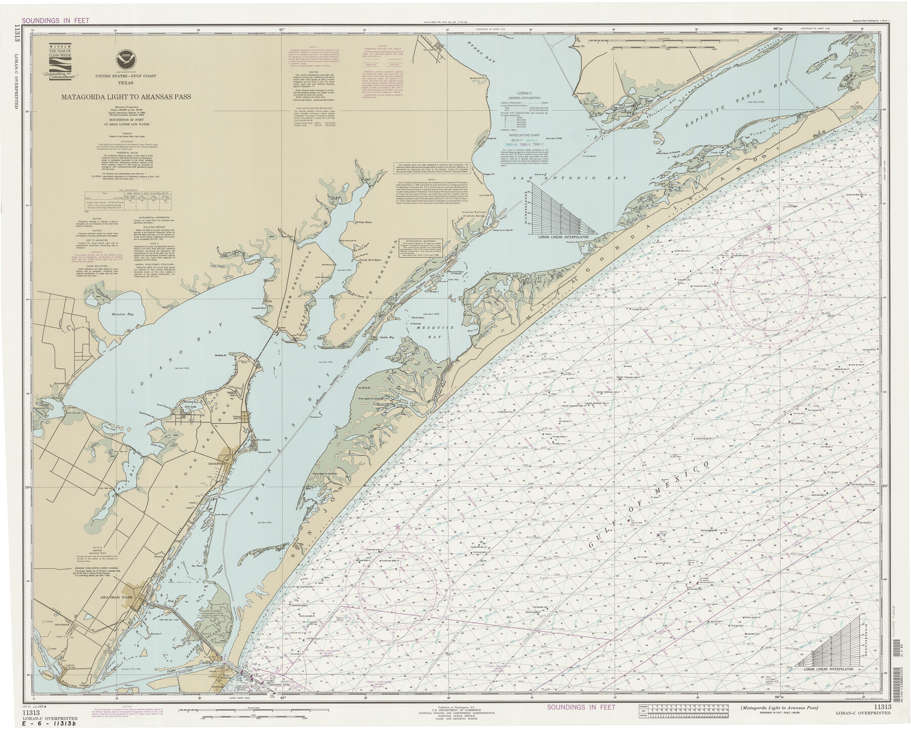
Matagorda Light to Aransas Pass
K-6-1285a
-
Map/Doc
73405
-
Collection
General Map Collection
-
Object Dates
7/4/1992 (Creation Date)
-
Counties
Refugio San Patricio Aransas
-
Subjects
Nautical Charts
-
Height x Width
35.5 x 44.2 inches
90.2 x 112.3 cm
Part of: General Map Collection
Starr County Boundary File 1a

Print $20.00
- Digital $50.00
Starr County Boundary File 1a
Size 22.4 x 41.0 inches
Map/Doc 58813
Crockett County Working Sketch 44

Print $20.00
- Digital $50.00
Crockett County Working Sketch 44
1933
Size 34.2 x 17.4 inches
Map/Doc 68377
Map of Ramon Musquiz Survey, Meanders of Lavaca & Navidad Rivers, Menefee & Redfish Lakes

Print $20.00
- Digital $50.00
Map of Ramon Musquiz Survey, Meanders of Lavaca & Navidad Rivers, Menefee & Redfish Lakes
1934
Size 24.4 x 18.0 inches
Map/Doc 65453
Palo Pinto County Working Sketch 15

Print $20.00
- Digital $50.00
Palo Pinto County Working Sketch 15
1971
Size 26.4 x 30.8 inches
Map/Doc 71398
Coleman County Working Sketch 6

Print $20.00
- Digital $50.00
Coleman County Working Sketch 6
1939
Size 19.1 x 21.8 inches
Map/Doc 68072
Dawson County Working Sketch 22

Print $20.00
- Digital $50.00
Dawson County Working Sketch 22
1989
Size 26.2 x 20.5 inches
Map/Doc 68566
Mitchell County Sketch File X

Print $20.00
- Digital $50.00
Mitchell County Sketch File X
1908
Size 29.9 x 17.7 inches
Map/Doc 12104
Jefferson County Working Sketch 42

Print $20.00
- Digital $50.00
Jefferson County Working Sketch 42
1996
Size 31.7 x 47.2 inches
Map/Doc 66586
Upton County Working Sketch 12

Print $40.00
- Digital $50.00
Upton County Working Sketch 12
1937
Size 43.6 x 77.9 inches
Map/Doc 69508
Bee County Working Sketch 15

Print $20.00
- Digital $50.00
Bee County Working Sketch 15
1974
Size 20.4 x 27.9 inches
Map/Doc 67265
J No. 4 - Reconnaissance of Catalina Harbor And the Anchorage on the N.E. Side of the Island, California

Print $20.00
- Digital $50.00
J No. 4 - Reconnaissance of Catalina Harbor And the Anchorage on the N.E. Side of the Island, California
1852
Size 18.3 x 13.1 inches
Map/Doc 97231
Webb County Sketch File 60

Print $8.00
- Digital $50.00
Webb County Sketch File 60
1943
Size 14.4 x 8.9 inches
Map/Doc 39855
You may also like
The Republic County of Nacogdoches. Proposed, Late Fall 1837

Print $20.00
The Republic County of Nacogdoches. Proposed, Late Fall 1837
2020
Size 17.5 x 21.7 inches
Map/Doc 96242
Borden County Rolled Sketch 11

Print $20.00
- Digital $50.00
Borden County Rolled Sketch 11
1963
Size 33.2 x 32.2 inches
Map/Doc 8450
General Highway Map, Nueces County, Texas

Print $20.00
General Highway Map, Nueces County, Texas
1961
Size 24.9 x 18.4 inches
Map/Doc 79615
In the Supreme Court of the United States, The State of Oklahoma, Complainant vs. The State of Texas, Defendant, The United States of America, Intervener, Red River Valley, Texas and Oklahoma Between the 98th and 100th Meridians in Five Sheets, 1921

Print $40.00
- Digital $50.00
In the Supreme Court of the United States, The State of Oklahoma, Complainant vs. The State of Texas, Defendant, The United States of America, Intervener, Red River Valley, Texas and Oklahoma Between the 98th and 100th Meridians in Five Sheets, 1921
1921
Size 38.6 x 60.0 inches
Map/Doc 75276
PSL Field Notes for Blocks 58, 59, 60 1/2, 61 1/2, 62 1/2, 63 1/2, 64 1/2, 65 1/2, 66 1/2, 67 1/2, 68 1/2, 69 1/2, 70, 71, and 72 in Hudspeth County

PSL Field Notes for Blocks 58, 59, 60 1/2, 61 1/2, 62 1/2, 63 1/2, 64 1/2, 65 1/2, 66 1/2, 67 1/2, 68 1/2, 69 1/2, 70, 71, and 72 in Hudspeth County
Map/Doc 81662
P.J. Lawless Addition of part of Outlots 29 and 30, Division D, Austin, Texas

Print $20.00
- Digital $50.00
P.J. Lawless Addition of part of Outlots 29 and 30, Division D, Austin, Texas
1916
Size 13.7 x 17.1 inches
Map/Doc 620
Bandera County Working Sketch 37

Print $20.00
- Digital $50.00
Bandera County Working Sketch 37
1970
Size 23.6 x 25.0 inches
Map/Doc 67633
Williamson County Boundary File 3

Print $20.00
- Digital $50.00
Williamson County Boundary File 3
Size 18.5 x 23.6 inches
Map/Doc 60012
Harris County NRC Article 33.136 Location Key Sheet

Print $20.00
- Digital $50.00
Harris County NRC Article 33.136 Location Key Sheet
1995
Size 27.0 x 21.8 inches
Map/Doc 77027
[Hutchinson County, Blocks R, XO, M-22, M-25]
![91152, [Hutchinson County, Blocks R, XO, M-22, M-25], Twichell Survey Records](https://historictexasmaps.com/wmedia_w700/maps/91152-1.tif.jpg)
Print $20.00
- Digital $50.00
[Hutchinson County, Blocks R, XO, M-22, M-25]
Size 28.5 x 25.9 inches
Map/Doc 91152
Map of Childress, Childress County, Texas on the Line of the Fort Worth and Denver City Railway, Texas Pan-Handle Route

Print $20.00
- Digital $50.00
Map of Childress, Childress County, Texas on the Line of the Fort Worth and Denver City Railway, Texas Pan-Handle Route
1888
Size 35.6 x 28.0 inches
Map/Doc 7691
Map of the Surveyed Part of Young District

Print $40.00
- Digital $50.00
Map of the Surveyed Part of Young District
1860
Size 56.2 x 54.7 inches
Map/Doc 1986