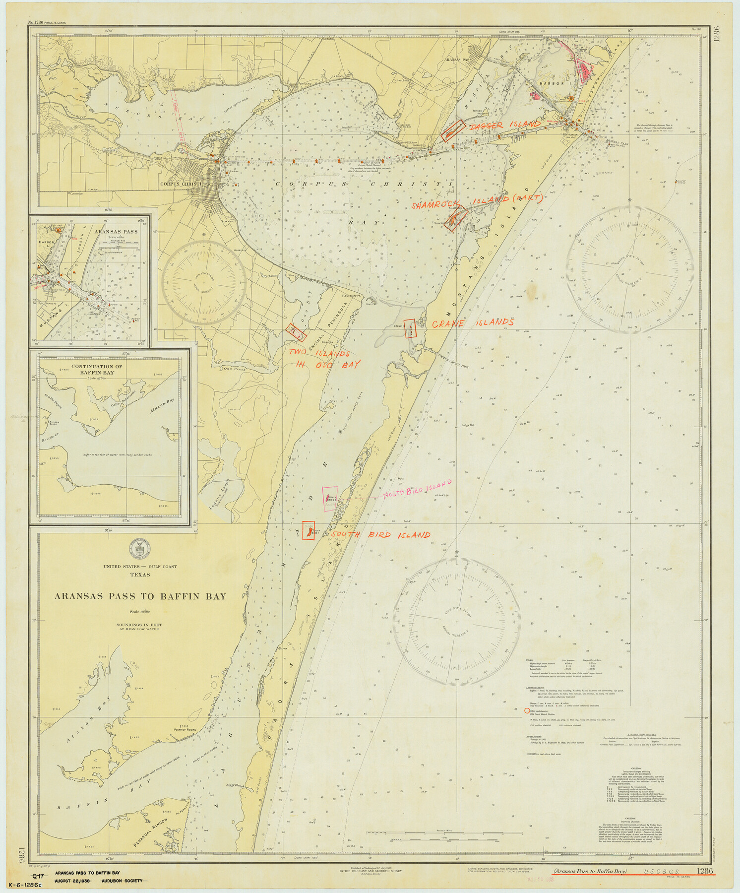
Aransas Pass to Baffin Bay
-
Map/Doc
73411
-
Collection
General Map Collection
-
Object Dates
1938/3/3 (Creation Date)
-
Counties
Aransas San Patricio Nueces Kleberg Kenedy
-
Subjects
Nautical Charts
-
Height x Width
41.6 x 34.5 inches
105.7 x 87.6 cm
-
Comments
Copy from National Archives
Part of: General Map Collection
Maps of Gulf Intracoastal Waterway, Texas - Sabine River to the Rio Grande and connecting waterways including ship channels

Print $20.00
- Digital $50.00
Maps of Gulf Intracoastal Waterway, Texas - Sabine River to the Rio Grande and connecting waterways including ship channels
1966
Size 14.5 x 22.2 inches
Map/Doc 61920
Kimble County Working Sketch 90

Print $20.00
- Digital $50.00
Kimble County Working Sketch 90
1979
Size 17.3 x 28.2 inches
Map/Doc 70158
Culberson County Rolled Sketch 40

Print $20.00
- Digital $50.00
Culberson County Rolled Sketch 40
Size 32.1 x 25.0 inches
Map/Doc 8751
The Making of America - Texas

The Making of America - Texas
1986
Size 20.7 x 27.3 inches
Map/Doc 96825
Hockley County Sketch File 13

Print $4.00
- Digital $50.00
Hockley County Sketch File 13
1914
Size 8.9 x 10.9 inches
Map/Doc 26548
Flight Mission No. CRC-3R, Frame 17, Chambers County

Print $20.00
- Digital $50.00
Flight Mission No. CRC-3R, Frame 17, Chambers County
1956
Size 18.6 x 22.2 inches
Map/Doc 84791
Coryell County Sketch File 20

Print $20.00
- Digital $50.00
Coryell County Sketch File 20
Size 25.8 x 20.1 inches
Map/Doc 11183
Potter County Sketch File 18

Print $20.00
- Digital $50.00
Potter County Sketch File 18
Size 34.3 x 43.4 inches
Map/Doc 10577
Kerr County Working Sketch 17

Print $20.00
- Digital $50.00
Kerr County Working Sketch 17
1956
Size 20.0 x 23.7 inches
Map/Doc 70048
Hartley County Working Sketch 8

Print $20.00
- Digital $50.00
Hartley County Working Sketch 8
1982
Size 34.0 x 32.6 inches
Map/Doc 66058

Val Verde County Rolled Sketch JR

Print $20.00
- Digital $50.00
Val Verde County Rolled Sketch JR
1938
Size 35.9 x 31.1 inches
Map/Doc 10080
You may also like
Flight Mission No. CRC-4R, Frame 101, Chambers County

Print $20.00
- Digital $50.00
Flight Mission No. CRC-4R, Frame 101, Chambers County
1956
Size 18.6 x 22.4 inches
Map/Doc 84898
Medina County Working Sketch 7

Print $20.00
- Digital $50.00
Medina County Working Sketch 7
1952
Size 26.3 x 28.5 inches
Map/Doc 70922
Sterling County Working Sketch 7

Print $20.00
- Digital $50.00
Sterling County Working Sketch 7
1957
Size 22.1 x 26.1 inches
Map/Doc 63989
Swisher County Working Sketch 4

Print $20.00
- Digital $50.00
Swisher County Working Sketch 4
1960
Size 23.0 x 19.9 inches
Map/Doc 62415
McCulloch County

Print $20.00
- Digital $50.00
McCulloch County
1874
Size 21.9 x 16.8 inches
Map/Doc 3856
Map of Kinney County, Texas

Print $20.00
- Digital $50.00
Map of Kinney County, Texas
1879
Size 21.2 x 33.1 inches
Map/Doc 548
Dickens County Sketch File 4

Print $20.00
- Digital $50.00
Dickens County Sketch File 4
Size 21.2 x 27.1 inches
Map/Doc 11317
The Republic County of Liberty. December 29, 1845

Print $20.00
The Republic County of Liberty. December 29, 1845
2020
Size 19.9 x 21.7 inches
Map/Doc 96213
Palo Pinto County

Print $20.00
- Digital $50.00
Palo Pinto County
1898
Size 46.3 x 39.1 inches
Map/Doc 66965
Brewster County Rolled Sketch 151

Print $20.00
- Digital $50.00
Brewster County Rolled Sketch 151
1996
Size 36.3 x 28.0 inches
Map/Doc 5318
Flight Mission No. BRA-7M, Frame 116, Jefferson County

Print $20.00
- Digital $50.00
Flight Mission No. BRA-7M, Frame 116, Jefferson County
1953
Size 18.6 x 22.5 inches
Map/Doc 85510
Newton County Sketch File 40

Print $6.00
- Digital $50.00
Newton County Sketch File 40
Size 16.2 x 10.6 inches
Map/Doc 32419