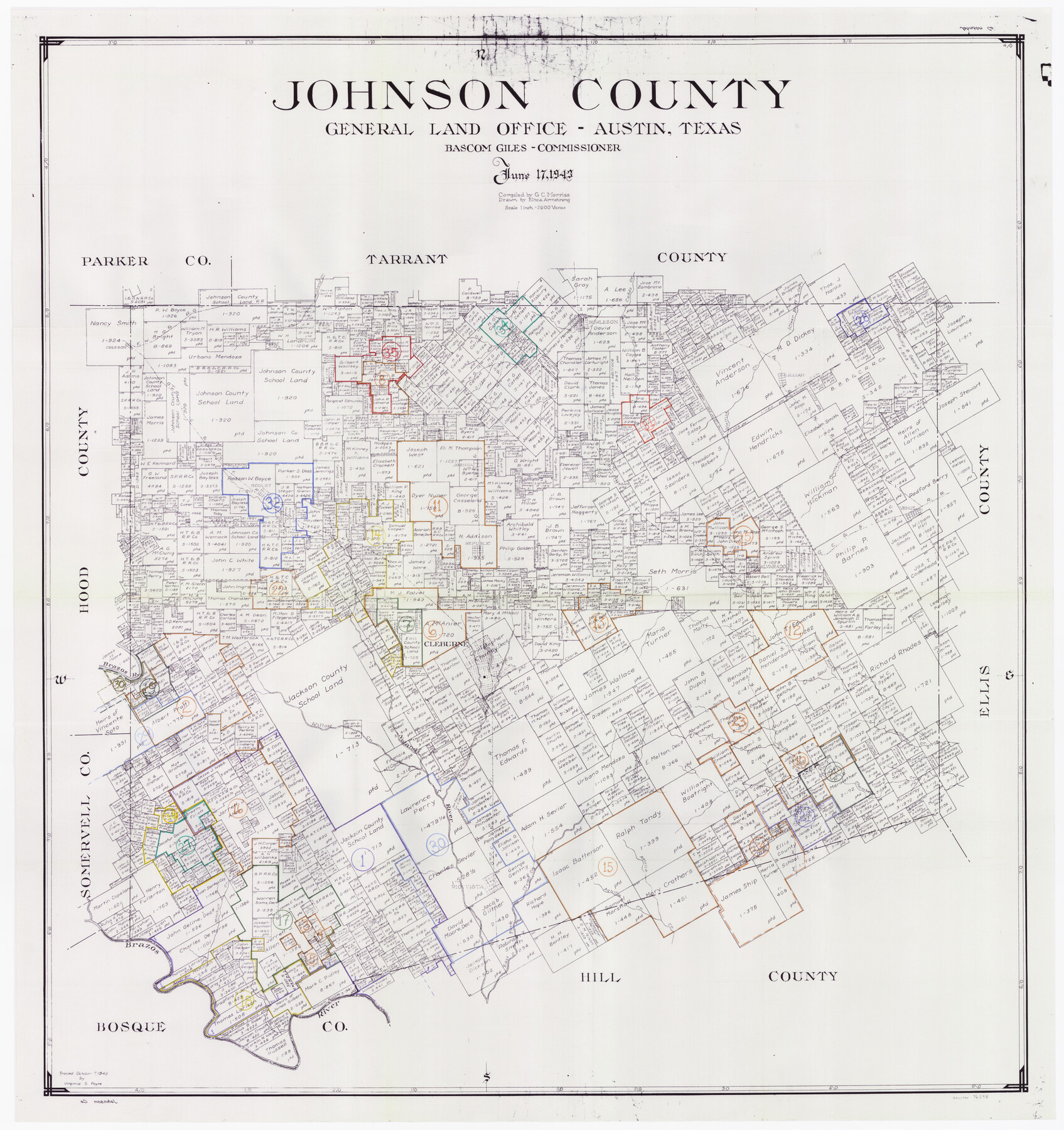
Johnson County Working Sketch Graphic Index
-
Map/Doc
76598
-
Collection
General Map Collection
-
Object Dates
6/17/1943 (Creation Date)
-
People and Organizations
G.C. Morriss (Compiler)
Eltea Armstrong (Draftsman)
-
Counties
Johnson
-
Subjects
County Surveying Working Sketch
-
Height x Width
40.7 x 38.3 inches
103.4 x 97.3 cm
-
Scale
1" = 2000 varas
Part of: General Map Collection
Hardin County Rolled Sketch 6

Print $20.00
- Digital $50.00
Hardin County Rolled Sketch 6
1938
Size 29.7 x 22.7 inches
Map/Doc 6079
Menard County Rolled Sketch 18

Print $20.00
- Digital $50.00
Menard County Rolled Sketch 18
2024
Size 35.9 x 47.7 inches
Map/Doc 97427
Harris County Working Sketch 57

Print $20.00
- Digital $50.00
Harris County Working Sketch 57
1951
Size 21.7 x 20.0 inches
Map/Doc 65949
Hale County Sketch File 9

Print $14.00
- Digital $50.00
Hale County Sketch File 9
1893
Size 6.1 x 2.6 inches
Map/Doc 24730
Hardeman County Aerial Photograph Index Sheet 3

Print $20.00
- Digital $50.00
Hardeman County Aerial Photograph Index Sheet 3
1950
Size 20.3 x 17.0 inches
Map/Doc 83699
Flight Mission No. DQO-7K, Frame 103, Galveston County

Print $20.00
- Digital $50.00
Flight Mission No. DQO-7K, Frame 103, Galveston County
1952
Size 18.5 x 22.7 inches
Map/Doc 85118
[Maps of surveys in Reeves & Culberson Cos]
![61140, [Maps of surveys in Reeves & Culberson Cos], General Map Collection](https://historictexasmaps.com/wmedia_w700/maps/61140.tif.jpg)
Print $20.00
- Digital $50.00
[Maps of surveys in Reeves & Culberson Cos]
1937
Size 30.6 x 24.9 inches
Map/Doc 61140
Caldwell County

Print $20.00
- Digital $50.00
Caldwell County
1935
Size 37.8 x 42.0 inches
Map/Doc 73095
Kimble County Sketch File 1

Print $4.00
- Digital $50.00
Kimble County Sketch File 1
1854
Size 7.2 x 10.0 inches
Map/Doc 28907
Andrews County Rolled Sketch 31

Print $20.00
- Digital $50.00
Andrews County Rolled Sketch 31
Size 18.3 x 19.9 inches
Map/Doc 77175
Karnes County Rolled Sketch 4

Print $20.00
- Digital $50.00
Karnes County Rolled Sketch 4
1961
Size 33.4 x 37.7 inches
Map/Doc 9667
Flight Mission No. BRA-7M, Frame 87, Jefferson County

Print $20.00
- Digital $50.00
Flight Mission No. BRA-7M, Frame 87, Jefferson County
1953
Size 18.5 x 22.3 inches
Map/Doc 85509
You may also like
Schleicher County Working Sketch 8

Print $20.00
- Digital $50.00
Schleicher County Working Sketch 8
1923
Size 21.6 x 18.6 inches
Map/Doc 63810
Angelina County Working Sketch 6

Print $20.00
- Digital $50.00
Angelina County Working Sketch 6
1914
Size 17.5 x 15.1 inches
Map/Doc 67087
[Block 3 and part of Block 2]
![90760, [Block 3 and part of Block 2], Twichell Survey Records](https://historictexasmaps.com/wmedia_w700/maps/90760-1.tif.jpg)
Print $2.00
- Digital $50.00
[Block 3 and part of Block 2]
1882
Size 13.1 x 9.1 inches
Map/Doc 90760
Chart of the West Indies and Spanish Dominions in North America

Print $20.00
- Digital $50.00
Chart of the West Indies and Spanish Dominions in North America
1803
Size 25.6 x 39.2 inches
Map/Doc 97138
Midland County Rolled Sketch T

Print $20.00
- Digital $50.00
Midland County Rolled Sketch T
1933
Size 15.9 x 21.4 inches
Map/Doc 6772
Jackson County Rolled Sketch 3B

Print $20.00
- Digital $50.00
Jackson County Rolled Sketch 3B
1913
Size 23.7 x 21.8 inches
Map/Doc 6338
San Luis Pass to Matagorda Bay

Print $20.00
- Digital $50.00
San Luis Pass to Matagorda Bay
1946
Size 34.7 x 46.5 inches
Map/Doc 69961
Map showing Alamo-Donna Farms, Irrigated Section in Hidalgo County, Texas

Print $20.00
- Digital $50.00
Map showing Alamo-Donna Farms, Irrigated Section in Hidalgo County, Texas
1920
Size 27.5 x 13.3 inches
Map/Doc 95803
A new map for travellers through the United States of America showing the railroads, canals & stageroads with the distances

Print $20.00
- Digital $50.00
A new map for travellers through the United States of America showing the railroads, canals & stageroads with the distances
1846
Size 22.4 x 27.9 inches
Map/Doc 95921
Part of Garza, Crosby, Lynn, and Lubbock Counties

Print $20.00
- Digital $50.00
Part of Garza, Crosby, Lynn, and Lubbock Counties
1912
Size 39.6 x 26.0 inches
Map/Doc 92560
Calhoun County NRC Article 33.136 Sketch 5

Print $34.00
- Digital $50.00
Calhoun County NRC Article 33.136 Sketch 5
2012
Size 24.0 x 36.0 inches
Map/Doc 94633
Intracoastal Waterway in Texas - Corpus Christi to Point Isabel including Arroyo Colorado to Mo. Pac. R.R. Bridge Near Harlingen

Print $20.00
- Digital $50.00
Intracoastal Waterway in Texas - Corpus Christi to Point Isabel including Arroyo Colorado to Mo. Pac. R.R. Bridge Near Harlingen
1933
Size 28.1 x 41.2 inches
Map/Doc 61845