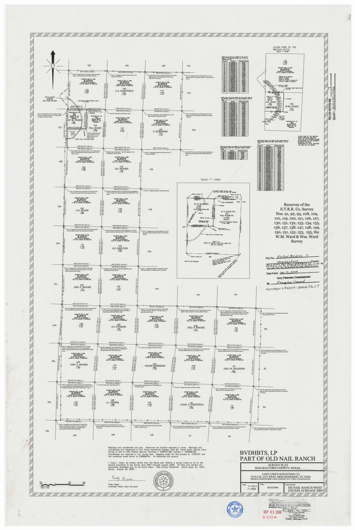
Shackelford County Rolled Sketch 7
Resurvey of the E. T. R.R. Co. survey nos. 91, 92, 93, 108, 109, 110, 119, 120, 121, 126, 127, 130, 131, 132, 133, 134, 135, 136, 137, 138, 147, 148, 149, 150, 151, 152, 153, 155, the W.M. Ward & Wm. Ward survey
-
Map/Doc
89229
-
Collection
General Map Collection
-
Object Dates
2009/8/28 (Creation Date)
2009/12/10 (File Date)
-
People and Organizations
Cody Owen (Surveyor/Engineer)
-
Counties
Shackelford
-
Subjects
Surveying Rolled Sketch
-
Height x Width
36.9 x 24.8 inches
93.7 x 63.0 cm
-
Medium
mylar, print
-
Scale
1" = 720 varas
Part of: General Map Collection
Crockett County Rolled Sketch 46C

Print $20.00
- Digital $50.00
Crockett County Rolled Sketch 46C
1954
Size 25.3 x 31.6 inches
Map/Doc 5782
Liberty County Rolled Sketch JP1

Print $40.00
- Digital $50.00
Liberty County Rolled Sketch JP1
1935
Size 41.9 x 60.8 inches
Map/Doc 9567
Nautical Chart 885-SC Intracoastal Waterway - Ellender to Galveston Bay, Louisiana-Texas

Print $40.00
- Digital $50.00
Nautical Chart 885-SC Intracoastal Waterway - Ellender to Galveston Bay, Louisiana-Texas
1972
Size 16.1 x 59.4 inches
Map/Doc 69836
Jeff Davis County Sketch File 29

Print $30.00
- Digital $50.00
Jeff Davis County Sketch File 29
Size 14.2 x 8.5 inches
Map/Doc 28008
Irion County Sketch File 10

Print $20.00
- Digital $50.00
Irion County Sketch File 10
1936
Size 16.7 x 30.5 inches
Map/Doc 11825
A Comprehensive Atlas Geographical, Historical & Commercial

A Comprehensive Atlas Geographical, Historical & Commercial
Size 13.0 x 10.7 inches
Map/Doc 95959
Flight Mission No. CRK-7P, Frame 134, Refugio County

Print $20.00
- Digital $50.00
Flight Mission No. CRK-7P, Frame 134, Refugio County
1956
Size 18.4 x 22.1 inches
Map/Doc 86957
King County Working Sketch 13

Print $20.00
- Digital $50.00
King County Working Sketch 13
1975
Size 33.0 x 47.8 inches
Map/Doc 70177
Map of subdivision of submerged land in the Gulf of Mexico fronting on Matagorda Island and Peninsula

Print $40.00
- Digital $50.00
Map of subdivision of submerged land in the Gulf of Mexico fronting on Matagorda Island and Peninsula
1940
Size 28.2 x 61.3 inches
Map/Doc 2929
Flight Mission No. CRC-3R, Frame 16, Chambers County

Print $20.00
- Digital $50.00
Flight Mission No. CRC-3R, Frame 16, Chambers County
1956
Size 18.6 x 22.2 inches
Map/Doc 84790
Maps of Gulf Intracoastal Waterway, Texas - Sabine River to the Rio Grande and connecting waterways including ship channels

Print $20.00
- Digital $50.00
Maps of Gulf Intracoastal Waterway, Texas - Sabine River to the Rio Grande and connecting waterways including ship channels
1966
Size 14.5 x 22.2 inches
Map/Doc 61928
You may also like
Wichita County Sketch File 28

Print $22.00
- Digital $50.00
Wichita County Sketch File 28
1929
Size 12.5 x 17.0 inches
Map/Doc 40130
Lee County Sketch File 4a

Print $4.00
- Digital $50.00
Lee County Sketch File 4a
1860
Size 12.9 x 8.2 inches
Map/Doc 29684
Robertson County Working Sketch 1

Print $20.00
- Digital $50.00
Robertson County Working Sketch 1
1923
Size 26.2 x 36.6 inches
Map/Doc 63574
The Republic County of Gonzales. December 18, 1837

Print $20.00
The Republic County of Gonzales. December 18, 1837
2020
Size 14.7 x 21.7 inches
Map/Doc 96154
Flight Mission No. BRE-1P, Frame 68, Nueces County

Print $20.00
- Digital $50.00
Flight Mission No. BRE-1P, Frame 68, Nueces County
1956
Size 17.7 x 21.8 inches
Map/Doc 86650
Real County Working Sketch 89

Print $20.00
- Digital $50.00
Real County Working Sketch 89
Size 28.0 x 37.1 inches
Map/Doc 71981
Brewster County Working Sketch 77

Print $20.00
- Digital $50.00
Brewster County Working Sketch 77
1968
Size 25.0 x 20.9 inches
Map/Doc 67677
Duval County Rolled Sketch 46

Print $20.00
- Digital $50.00
Duval County Rolled Sketch 46
1985
Size 24.9 x 36.1 inches
Map/Doc 5761
Sherman County Rolled Sketch 5

Print $20.00
- Digital $50.00
Sherman County Rolled Sketch 5
1919
Size 36.9 x 41.4 inches
Map/Doc 9928
Kimble County Working Sketch 13

Print $20.00
- Digital $50.00
Kimble County Working Sketch 13
1922
Size 23.8 x 20.8 inches
Map/Doc 70081
Presidio County Sketch File 1

Print $40.00
- Digital $50.00
Presidio County Sketch File 1
1857
Size 24.7 x 16.0 inches
Map/Doc 11703
Wharton County Working Sketch 9

Print $3.00
- Digital $50.00
Wharton County Working Sketch 9
1982
Size 12.4 x 10.4 inches
Map/Doc 72473