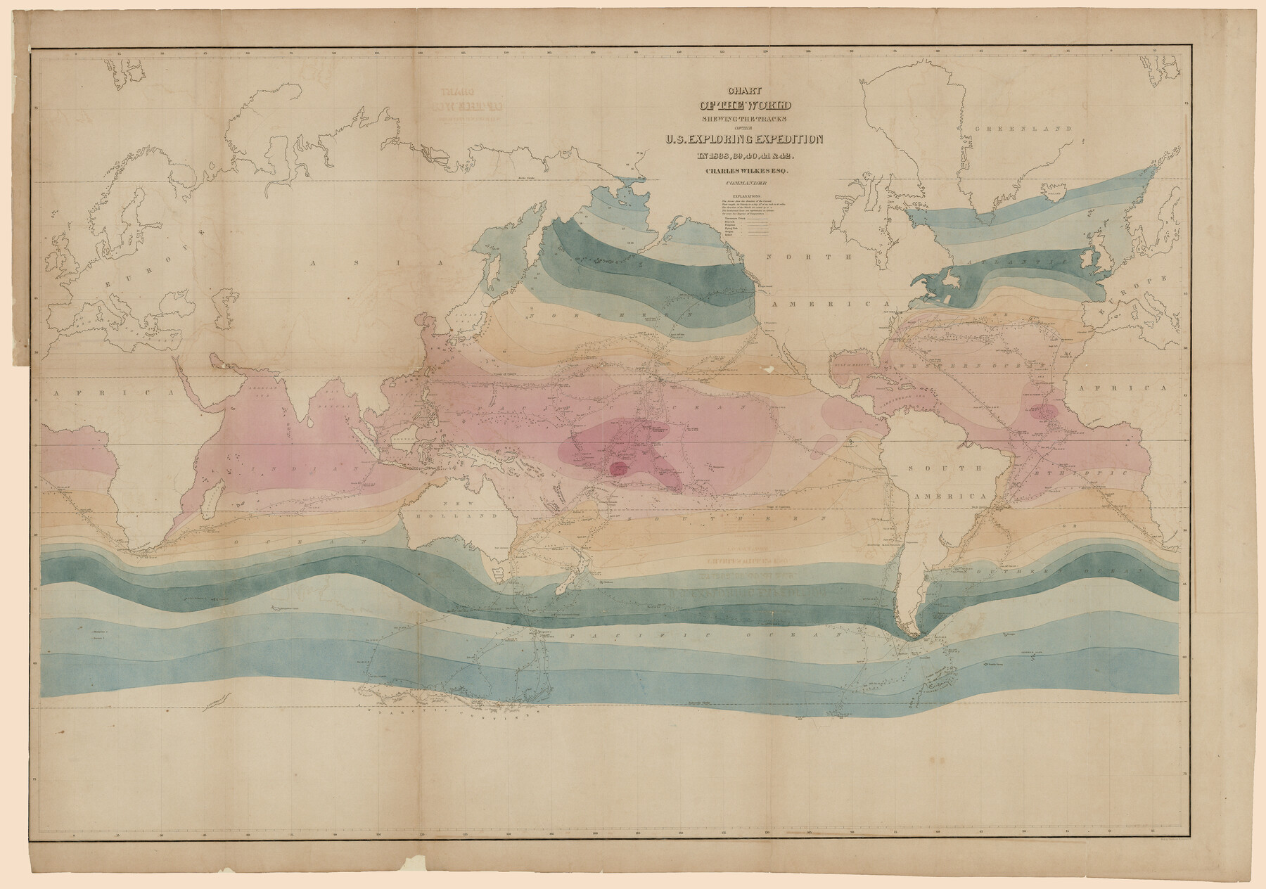
Chart of the World shewing the tracks of the U.S. Exploring Expedition in 1833, 39, 40, 41 & 42
-
Map/Doc
94057
-
Collection
Rees-Jones Digital Map Collection
-
Object Dates
1842 (Creation Date)
-
People and Organizations
Sherman & Smith (Printer)
Charles Wilkes (Author)
-
Subjects
Nautical Charts World
-
Height x Width
26.3 x 37.4 inches
66.8 x 95.0 cm
-
Medium
digital image
-
Comments
Courtesy of the Rees-Jones Collection, Dallas, TX
Part of: Rees-Jones Digital Map Collection
A New Map of Texas, Oregon and California with the regions adjoining, compiled from the most recent authorities

Print $20.00
- Digital $50.00
A New Map of Texas, Oregon and California with the regions adjoining, compiled from the most recent authorities
Size 22.8 x 20.9 inches
Map/Doc 93990
A new map of Texas, Oregon and California with the regions adjoining, compiled from the most recent authorities

Print $20.00
- Digital $50.00
A new map of Texas, Oregon and California with the regions adjoining, compiled from the most recent authorities
1846
Size 23.7 x 21.8 inches
Map/Doc 93940
J.K Gill & Cos Map of Oregon

Print $20.00
- Digital $50.00
J.K Gill & Cos Map of Oregon
1882
Size 29.0 x 32.3 inches
Map/Doc 94055
J. De Cordova's Map of the State of Texas Compiled from the records of the General Land Office of the State

Print $20.00
- Digital $50.00
J. De Cordova's Map of the State of Texas Compiled from the records of the General Land Office of the State
Size 38.5 x 36.4 inches
Map/Doc 93984
Part of the boundary between the United States and Texas; north of Sabine River, from the 72nd mile mound to the Red River

Print $3.00
- Digital $50.00
Part of the boundary between the United States and Texas; north of Sabine River, from the 72nd mile mound to the Red River
1842
Size 12.8 x 8.1 inches
Map/Doc 93771
Langtree's New Sectional Map of the State of Arkansas

Print $20.00
- Digital $50.00
Langtree's New Sectional Map of the State of Arkansas
Size 34.6 x 38.4 inches
Map/Doc 93987
Geological map of Texas showing approximate locations and drilling wells. Also names of companies drilling

Print $20.00
- Digital $50.00
Geological map of Texas showing approximate locations and drilling wells. Also names of companies drilling
1920
Size 26.9 x 26.6 inches
Map/Doc 93937
Nouvelle carte du Mexique, du Texas et d'une partie des États Limitrophes

Print $20.00
- Digital $50.00
Nouvelle carte du Mexique, du Texas et d'une partie des États Limitrophes
1834
Size 39.5 x 27.2 inches
Map/Doc 93764
Chart of the Antarctic Continent shewing the icy barrier attached to it discovered by the U.S. Ex. Ex.

Print $20.00
- Digital $50.00
Chart of the Antarctic Continent shewing the icy barrier attached to it discovered by the U.S. Ex. Ex.
1840
Size 26.5 x 37.2 inches
Map/Doc 94058
New Map of the Mining Regions of Idaho and Montana showing the geographical positions of the Blackfoot, Owyhee & South Boise Mines and the various routes thereto

Print $20.00
- Digital $50.00
New Map of the Mining Regions of Idaho and Montana showing the geographical positions of the Blackfoot, Owyhee & South Boise Mines and the various routes thereto
Size 21.9 x 29.4 inches
Map/Doc 93991
A New Map of Texas with the Contiguous American & Mexican States

Print $20.00
- Digital $50.00
A New Map of Texas with the Contiguous American & Mexican States
1839
Size 13.5 x 16.1 inches
Map/Doc 93941
Plan of the cities of Denver, Auraria and Highland, Jefferson Terr.

Print $20.00
- Digital $50.00
Plan of the cities of Denver, Auraria and Highland, Jefferson Terr.
1859
Size 23.7 x 29.8 inches
Map/Doc 94053
You may also like
Flight Mission No. CRC-3R, Frame 40, Chambers County

Print $20.00
- Digital $50.00
Flight Mission No. CRC-3R, Frame 40, Chambers County
1956
Size 18.6 x 22.3 inches
Map/Doc 84813
Brown County Working Sketch 3

Print $20.00
- Digital $50.00
Brown County Working Sketch 3
1919
Size 29.1 x 21.5 inches
Map/Doc 67768
Orange County, West Half of Sabine River Showing Leases 5 and 6

Print $20.00
- Digital $50.00
Orange County, West Half of Sabine River Showing Leases 5 and 6
1957
Size 30.6 x 34.3 inches
Map/Doc 1934
[Skeleton Sketch of Unlabeled Surveys in Travis County, Texas]
![382, [Skeleton Sketch of Unlabeled Surveys in Travis County, Texas], Maddox Collection](https://historictexasmaps.com/wmedia_w700/maps/382.tif.jpg)
Print $20.00
- Digital $50.00
[Skeleton Sketch of Unlabeled Surveys in Travis County, Texas]
Size 28.9 x 36.8 inches
Map/Doc 382
Jasper County Working Sketch 16

Print $20.00
- Digital $50.00
Jasper County Working Sketch 16
1928
Size 13.7 x 14.3 inches
Map/Doc 66478
Goliad County Sketch File 36

Print $20.00
- Digital $50.00
Goliad County Sketch File 36
1925
Size 17.1 x 14.1 inches
Map/Doc 11571
Galveston County NRC Article 33.136 Sketch 52

Print $26.00
- Digital $50.00
Galveston County NRC Article 33.136 Sketch 52
2008
Size 24.0 x 36.0 inches
Map/Doc 94612
Flight Mission No. CUG-1P, Frame 111, Kleberg County

Print $20.00
- Digital $50.00
Flight Mission No. CUG-1P, Frame 111, Kleberg County
1956
Size 18.5 x 22.2 inches
Map/Doc 86161
Cass County Working Sketch 24

Print $20.00
- Digital $50.00
Cass County Working Sketch 24
1973
Size 35.6 x 27.7 inches
Map/Doc 67927
The Chief Justice County of Matagorda. March 30, 1837

Print $20.00
The Chief Justice County of Matagorda. March 30, 1837
2020
Size 19.7 x 21.7 inches
Map/Doc 96057
Flight Mission No. BRA-7M, Frame 135, Jefferson County

Print $20.00
- Digital $50.00
Flight Mission No. BRA-7M, Frame 135, Jefferson County
1953
Size 18.6 x 22.4 inches
Map/Doc 85529
Guadalupe County Working Sketch Graphic Index

Print $20.00
- Digital $50.00
Guadalupe County Working Sketch Graphic Index
1977
Size 35.5 x 46.5 inches
Map/Doc 76561