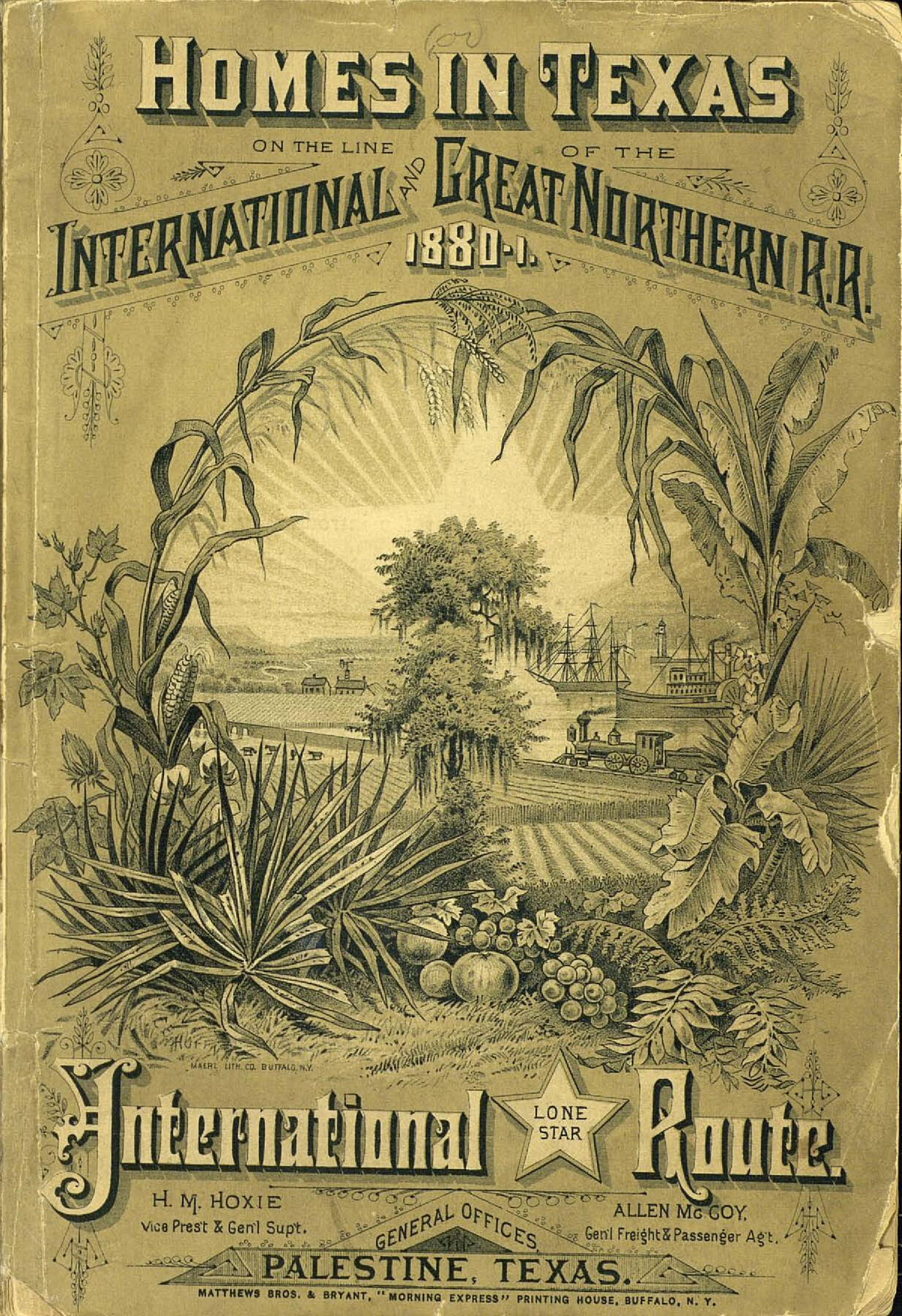
Homes in Texas on the line of the International and Great Northern R.R.
International Lone Star Route
-
Map/Doc
94093
-
Collection
General Map Collection
-
Object Dates
1881 (Creation Date)
-
People and Organizations
International and Great Northern Railroad (Publisher)
Matthews Bros. & Bryant, "Morning Express" (Printer)
Allen McCoy (Agent)
H.M. Hoxie (Agent)
-
Subjects
Bound Volume Railroads
-
Height x Width
9.1 x 6.3 inches
23.1 x 16.0 cm
-
Medium
paper, bound volume
-
Comments
See 94092 for map that was issued with this booklet.
Part of: General Map Collection
Childress Co.

Print $20.00
- Digital $50.00
Childress Co.
1978
Size 44.6 x 33.7 inches
Map/Doc 77237
Travis County State Real Property Sketch 14

Print $40.00
- Digital $50.00
Travis County State Real Property Sketch 14
1995
Size 18.1 x 23.9 inches
Map/Doc 61672
Coke County Working Sketch 25
Print $20.00
- Digital $50.00
Coke County Working Sketch 25
1961
Size 31.4 x 40.7 inches
Map/Doc 68062
Zavala County Sketch File 12

Print $54.00
- Digital $50.00
Zavala County Sketch File 12
1886
Size 9.0 x 7.7 inches
Map/Doc 41279
Montgomery County Rolled Sketch 29

Print $20.00
- Digital $50.00
Montgomery County Rolled Sketch 29
1948
Size 36.4 x 31.7 inches
Map/Doc 9537
Gaines County Sketch File 4

Print $4.00
- Digital $50.00
Gaines County Sketch File 4
1902
Size 14.3 x 8.5 inches
Map/Doc 23175
San Luis Pass to East Matagorda Bay
Print $40.00
- Digital $50.00
San Luis Pass to East Matagorda Bay
1982
Size 35.6 x 49.3 inches
Map/Doc 69970
Flight Mission No. DAG-23K, Frame 143, Matagorda County

Print $20.00
- Digital $50.00
Flight Mission No. DAG-23K, Frame 143, Matagorda County
1953
Size 15.8 x 15.7 inches
Map/Doc 86491
Bee County Sketch File 31

Print $6.00
- Digital $50.00
Bee County Sketch File 31
1886
Size 12.8 x 8.2 inches
Map/Doc 14344
Lee County Boundary File 2

Print $25.00
- Digital $50.00
Lee County Boundary File 2
Size 14.2 x 8.6 inches
Map/Doc 56269
Right of Way and Track Map, The Missouri, Kansas and Texas Ry. of Texas operated by the Missouri, Kansas and Texas Ry. of Texas, Henrietta Division

Print $40.00
- Digital $50.00
Right of Way and Track Map, The Missouri, Kansas and Texas Ry. of Texas operated by the Missouri, Kansas and Texas Ry. of Texas, Henrietta Division
1918
Size 24.8 x 56.3 inches
Map/Doc 64069
Uvalde County Rolled Sketch 15

Print $20.00
- Digital $50.00
Uvalde County Rolled Sketch 15
1979
Size 26.9 x 23.9 inches
Map/Doc 8099
You may also like
Brewster County Working Sketch 94

Print $40.00
- Digital $50.00
Brewster County Working Sketch 94
1975
Size 58.7 x 39.5 inches
Map/Doc 67694
Erath County Sketch File 35

Print $8.00
- Digital $50.00
Erath County Sketch File 35
1992
Size 14.5 x 8.8 inches
Map/Doc 22326
Wheeler County Working Sketch 18

Print $20.00
- Digital $50.00
Wheeler County Working Sketch 18
Size 38.0 x 41.8 inches
Map/Doc 72507
Louisiana and Texas Intracoastal Waterway - Dredging Tributary Channel, Port Aransas to Aransas Pass, Texas

Print $20.00
- Digital $50.00
Louisiana and Texas Intracoastal Waterway - Dredging Tributary Channel, Port Aransas to Aransas Pass, Texas
1940
Size 31.1 x 42.3 inches
Map/Doc 61820
Edwards County Working Sketch 137, revised

Print $20.00
- Digital $50.00
Edwards County Working Sketch 137, revised
1997
Size 33.6 x 35.1 inches
Map/Doc 69014
Limestone County Working Sketch 12

Print $20.00
- Digital $50.00
Limestone County Working Sketch 12
1922
Size 18.5 x 12.8 inches
Map/Doc 70562
Wilbarger County Sketch File 19

Print $4.00
- Digital $50.00
Wilbarger County Sketch File 19
1887
Size 14.2 x 8.7 inches
Map/Doc 40215
General Highway Map. Detail of Cities and Towns in Milam County, Texas [Rockdale and Cameron and vicinities]
![79598, General Highway Map. Detail of Cities and Towns in Milam County, Texas [Rockdale and Cameron and vicinities], Texas State Library and Archives](https://historictexasmaps.com/wmedia_w700/maps/79598.tif.jpg)
Print $20.00
General Highway Map. Detail of Cities and Towns in Milam County, Texas [Rockdale and Cameron and vicinities]
1961
Size 18.1 x 24.6 inches
Map/Doc 79598
Duval County Sketch File 6c

Print $5.00
- Digital $50.00
Duval County Sketch File 6c
1875
Size 8.2 x 11.0 inches
Map/Doc 21292
Flight Mission No. BRE-1P, Frame 105, Nueces County

Print $20.00
- Digital $50.00
Flight Mission No. BRE-1P, Frame 105, Nueces County
1956
Size 18.4 x 22.2 inches
Map/Doc 86676
[T. & P. Blocks 43-44, Townships 1S, 2S and 1N]
![90830, [T. & P. Blocks 43-44, Townships 1S, 2S and 1N], Twichell Survey Records](https://historictexasmaps.com/wmedia_w700/maps/90830-2.tif.jpg)
Print $20.00
- Digital $50.00
[T. & P. Blocks 43-44, Townships 1S, 2S and 1N]
Size 18.8 x 22.6 inches
Map/Doc 90830
McLennan County Sketch File 12

Print $4.00
- Digital $50.00
McLennan County Sketch File 12
Size 8.3 x 9.3 inches
Map/Doc 31265