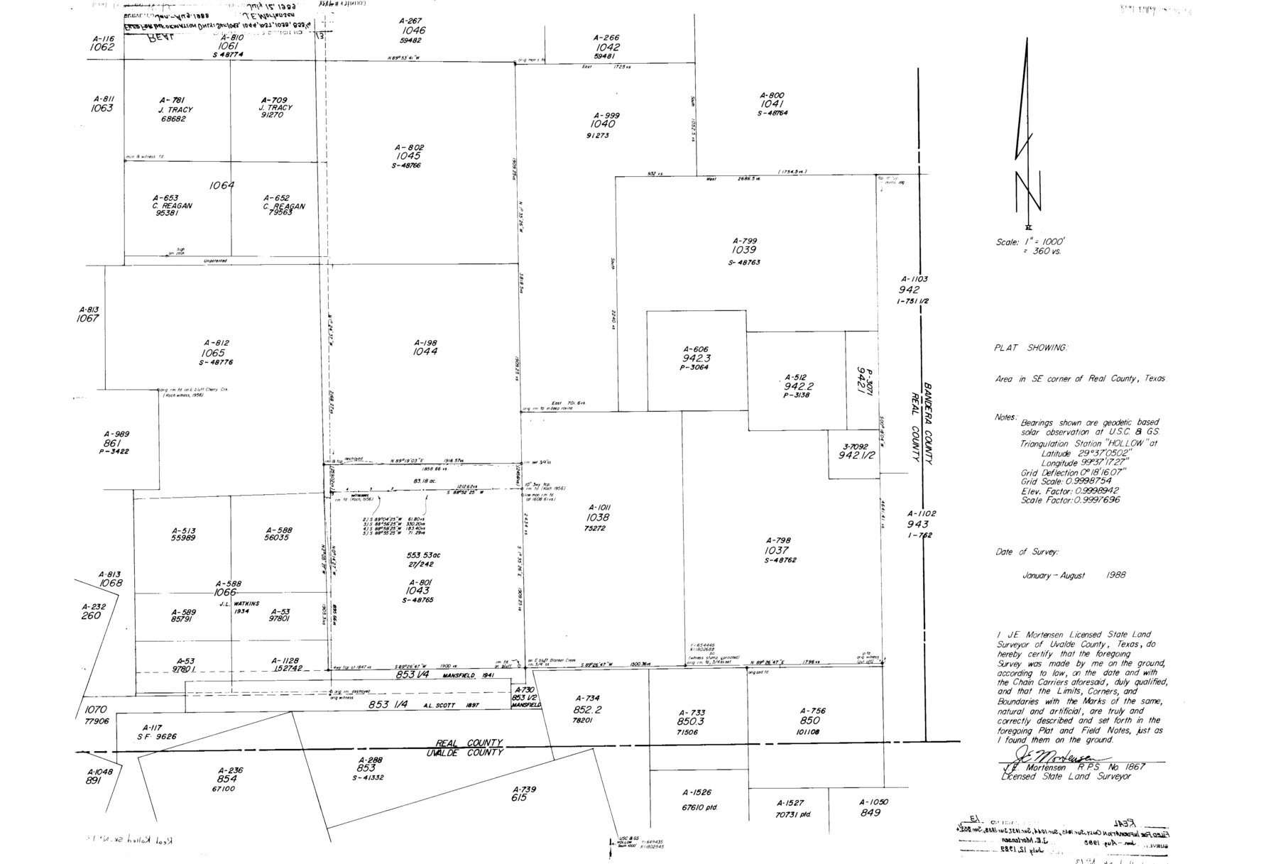
Real County Rolled Sketch 13
Plat showing area in SE corner of Real County, Texas
-
Map/Doc
9838
-
Collection
General Map Collection
-
Object Dates
1988 (Survey Date)
1989/7/12 (File Date)
-
People and Organizations
James E. Mortensen (Surveyor/Engineer)
-
Counties
Real
-
Subjects
Surveying Rolled Sketch
-
Height x Width
23.0 x 34.0 inches
58.4 x 86.4 cm
-
Medium
mylar, print
-
Scale
1" = 360 varas
Part of: General Map Collection
Limestone County Sketch File 17

Print $10.00
- Digital $50.00
Limestone County Sketch File 17
Size 14.4 x 8.7 inches
Map/Doc 30187
Bandera County Working Sketch 59

Print $20.00
- Digital $50.00
Bandera County Working Sketch 59
2003
Size 41.1 x 33.9 inches
Map/Doc 78346
Right of Way and Track Map, Galveston, Harrisburg & San Antonio Ry. operated by the T. & N. O. R.R. Co., Victoria Division, Rosenberg to Beeville

Print $40.00
- Digital $50.00
Right of Way and Track Map, Galveston, Harrisburg & San Antonio Ry. operated by the T. & N. O. R.R. Co., Victoria Division, Rosenberg to Beeville
1918
Size 24.4 x 57.9 inches
Map/Doc 76158
McCulloch County Working Sketch 11

Print $20.00
- Digital $50.00
McCulloch County Working Sketch 11
1983
Size 35.1 x 43.3 inches
Map/Doc 70686
Wood County Sketch File 6

Print $8.00
- Digital $50.00
Wood County Sketch File 6
1877
Size 8.2 x 5.4 inches
Map/Doc 40641
Flight Mission No. DQO-3K, Frame 82, Galveston County

Print $20.00
- Digital $50.00
Flight Mission No. DQO-3K, Frame 82, Galveston County
1952
Size 18.7 x 22.5 inches
Map/Doc 85087
Sketch exhibiting inland channel from Saluria to Corpus Christi traced from a copy of a map belonging to U. S. Engr. Dept.

Print $20.00
- Digital $50.00
Sketch exhibiting inland channel from Saluria to Corpus Christi traced from a copy of a map belonging to U. S. Engr. Dept.
1853
Size 18.3 x 28.3 inches
Map/Doc 73007
Flight Mission No. CGI-1N, Frame 137, Cameron County

Print $20.00
- Digital $50.00
Flight Mission No. CGI-1N, Frame 137, Cameron County
1955
Size 15.5 x 18.8 inches
Map/Doc 84493
Milam County Boundary File 65

Print $10.00
- Digital $50.00
Milam County Boundary File 65
Size 8.8 x 7.8 inches
Map/Doc 57251
Right of Way and Track Map, the Missouri, Kansas and Texas Ry. of Texas operated by the Missouri, Kansas and Texas Ry. of Texas, Henrietta Division

Print $40.00
- Digital $50.00
Right of Way and Track Map, the Missouri, Kansas and Texas Ry. of Texas operated by the Missouri, Kansas and Texas Ry. of Texas, Henrietta Division
1918
Size 25.1 x 56.4 inches
Map/Doc 64065
Dimmit County Sketch File 11a

Print $20.00
- Digital $50.00
Dimmit County Sketch File 11a
1880
Size 12.9 x 18.7 inches
Map/Doc 11339
Wilson County Boundary File 5

Print $20.00
- Digital $50.00
Wilson County Boundary File 5
Size 14.4 x 8.7 inches
Map/Doc 60109
You may also like
Nueces County Rolled Sketch 90

Print $129.00
Nueces County Rolled Sketch 90
1983
Size 24.8 x 37.1 inches
Map/Doc 7008
La Salle County Sketch File 32

Print $16.00
- Digital $50.00
La Salle County Sketch File 32
1883
Size 14.3 x 8.8 inches
Map/Doc 29576
Culberson County Working Sketch 62

Print $20.00
- Digital $50.00
Culberson County Working Sketch 62
1975
Size 32.2 x 24.6 inches
Map/Doc 68516
[Sketch showing H. & G. N. Blk. 1]
![89634, [Sketch showing H. & G. N. Blk. 1], Twichell Survey Records](https://historictexasmaps.com/wmedia_w700/maps/89634-1.tif.jpg)
Print $40.00
- Digital $50.00
[Sketch showing H. & G. N. Blk. 1]
Size 27.1 x 60.6 inches
Map/Doc 89634
The Republic County of Red River. Spring 1842

Print $20.00
The Republic County of Red River. Spring 1842
2020
Size 21.0 x 21.7 inches
Map/Doc 96254
Edwards Empresario Colony. April 15, 1825

Print $20.00
Edwards Empresario Colony. April 15, 1825
2020
Size 18.1 x 21.6 inches
Map/Doc 95993
Scurry County Rolled Sketch 11

Print $20.00
- Digital $50.00
Scurry County Rolled Sketch 11
Size 20.2 x 16.8 inches
Map/Doc 7771
Eastland County Boundary File 1

Print $10.00
- Digital $50.00
Eastland County Boundary File 1
Size 11.1 x 8.5 inches
Map/Doc 52780
Galveston County Rolled Sketch Z61

Print $20.00
- Digital $50.00
Galveston County Rolled Sketch Z61
1934
Size 34.9 x 23.0 inches
Map/Doc 5993
Shelby County Sketch File 11

Print $50.00
- Digital $50.00
Shelby County Sketch File 11
1859
Size 8.8 x 7.0 inches
Map/Doc 36613
Deaf Smith County Rolled Sketch 1

Print $20.00
- Digital $50.00
Deaf Smith County Rolled Sketch 1
1965
Size 24.8 x 25.9 inches
Map/Doc 5698
Matagorda County Sketch File 3

Print $4.00
- Digital $50.00
Matagorda County Sketch File 3
1876
Size 12.9 x 8.0 inches
Map/Doc 30732