Bastrop County Sketch File 9

Print $40.00
- Digital $50.00
Bastrop County Sketch File 9
1943
Size: 46.5 x 20.6 inches
10320
[Surveys near the city of Bastrop]
Print $2.00
- Digital $50.00
[Surveys near the city of Bastrop]
1841
Size: 6.5 x 7.0 inches
107
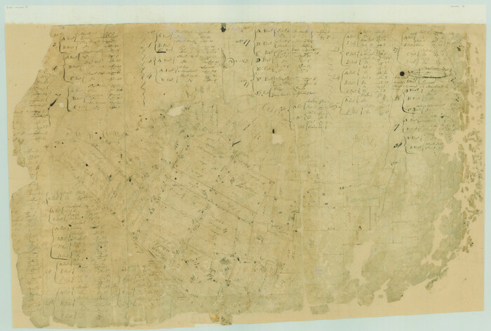
Travis County Sketch File ABC

Print $20.00
- Digital $50.00
Travis County Sketch File ABC
Size: 23.8 x 19.0 inches
12480
Bastrop County Sketch File 1

Print $6.00
- Digital $50.00
Bastrop County Sketch File 1
1846
Size: 8.1 x 9.8 inches
14037
Bastrop County Sketch File 1a

Print $4.00
- Digital $50.00
Bastrop County Sketch File 1a
Size: 8.4 x 12.8 inches
14040
Bastrop County Sketch File 2

Print $4.00
- Digital $50.00
Bastrop County Sketch File 2
1858
Size: 10.8 x 8.3 inches
14042
Bastrop County Sketch File 3

Print $4.00
- Digital $50.00
Bastrop County Sketch File 3
1860
Size: 8.9 x 9.2 inches
14044
Bastrop County Sketch File 4

Print $4.00
- Digital $50.00
Bastrop County Sketch File 4
1873
Size: 12.7 x 7.9 inches
14046
Bastrop County Sketch File 5

Print $4.00
- Digital $50.00
Bastrop County Sketch File 5
Size: 8.1 x 10.2 inches
14048
Bastrop County Sketch File 6

Print $4.00
- Digital $50.00
Bastrop County Sketch File 6
1875
Size: 8.8 x 7.8 inches
14050
Bastrop County Sketch File 7

Print $40.00
- Digital $50.00
Bastrop County Sketch File 7
Size: 13.2 x 12.4 inches
14052
Bastrop County Sketch File 8

Print $4.00
- Digital $50.00
Bastrop County Sketch File 8
Size: 8.5 x 11.5 inches
14054
Bastrop County Sketch File 10

Print $4.00
- Digital $50.00
Bastrop County Sketch File 10
1979
Size: 14.3 x 8.8 inches
14056
Bastrop County Sketch File 11

Print $52.00
- Digital $50.00
Bastrop County Sketch File 11
Size: 11.2 x 8.7 inches
14058
Bastrop County Sketch File 12

Print $12.00
- Digital $50.00
Bastrop County Sketch File 12
1846
Size: 12.8 x 8.4 inches
14064
Bastrop County Sketch File 13

Print $6.00
- Digital $50.00
Bastrop County Sketch File 13
1845
Size: 10.1 x 15.8 inches
14070
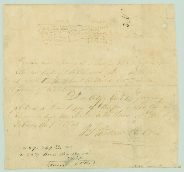
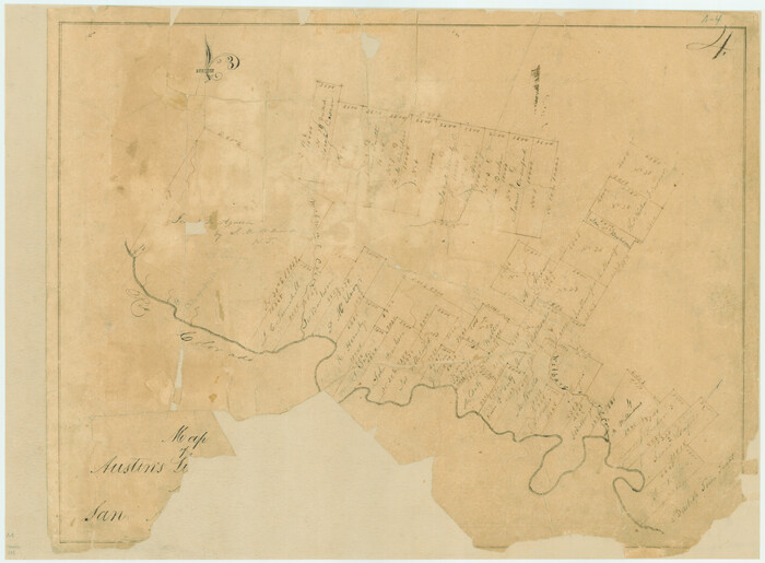
[Surveys in Austin's Colony along the San Antonio Road and the Colorado River]
Print $20.00
- Digital $50.00
[Surveys in Austin's Colony along the San Antonio Road and the Colorado River]
1821
Size: 17.3 x 25.6 inches
15
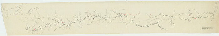
Bastrop County Boundary File 6

Print $40.00
- Digital $50.00
Bastrop County Boundary File 6
1923
Size: 15.4 x 102.0 inches
1691
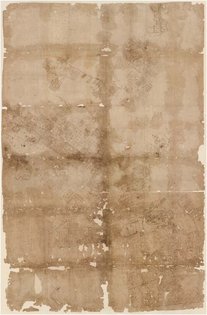
[Bastrop District]
Print $40.00
- Digital $50.00
[Bastrop District]
1838
Size: 67.3 x 44.2 inches
16941
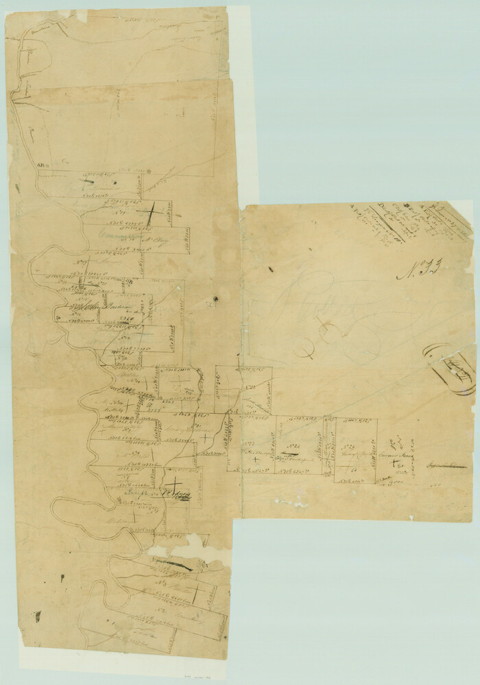
Surveys in Austin's Colony along the Colorado River below the San Antonio Road

Print $20.00
- Digital $50.00
Surveys in Austin's Colony along the Colorado River below the San Antonio Road
1830
Size: 38.2 x 13.5 inches
193
[Surveys by Brown in Austin's Little Colony along the Colorado River and Walnut Creek]
Print $20.00
- Digital $50.00
[Surveys by Brown in Austin's Little Colony along the Colorado River and Walnut Creek]
1832
Size: 33.2 x 23.3 inches
196
[Surveys in Austin's Colony along the Colorado River]
Print $20.00
- Digital $50.00
[Surveys in Austin's Colony along the Colorado River]
1830
Size: 38.9 x 23.2 inches
198
[Traverse up the Brazos and Colorado River showing distance from county site to county site]
Print $40.00
- Digital $50.00
[Traverse up the Brazos and Colorado River showing distance from county site to county site]
1871
Size: 16.2 x 98.8 inches
2054
Map of Austin's Li[ttle Colony Above the] San [Antonio Road]
Print $20.00
- Digital $50.00
Map of Austin's Li[ttle Colony Above the] San [Antonio Road]
1831
Size: 14.2 x 19.3 inches
215
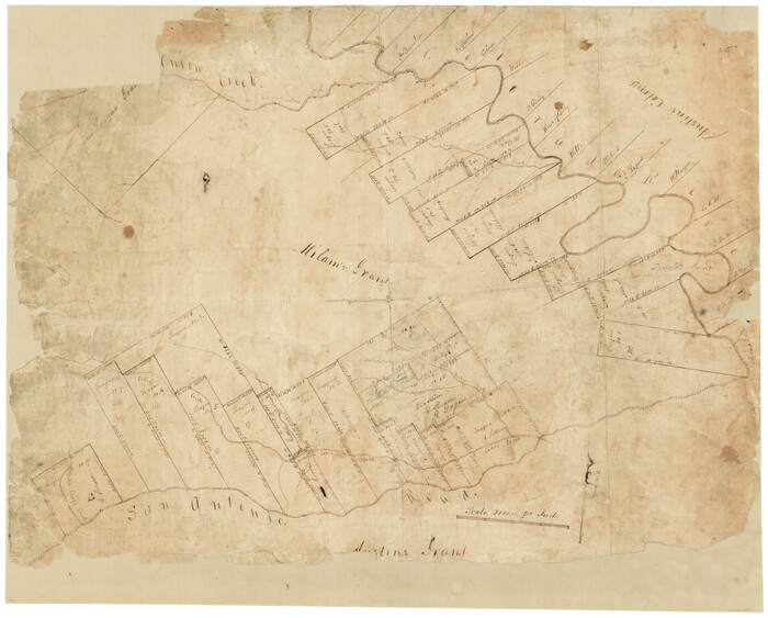
[Surveys in Milam's Colony between the Colorado River and northwest of the San Antonio Road]
Print $20.00
- Digital $50.00
[Surveys in Milam's Colony between the Colorado River and northwest of the San Antonio Road]
Size: 22.0 x 27.4 inches
29
Lee County Sketch File 9

Print $4.00
- Digital $50.00
Lee County Sketch File 9
Size: 8.8 x 8.2 inches
29709
[Bastrop District]
Print $40.00
- Digital $50.00
[Bastrop District]
1895
Size: 36.5 x 52.0 inches
3131
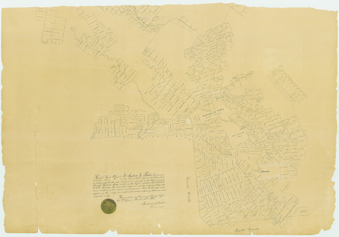
[Surveys in Bastrop County]
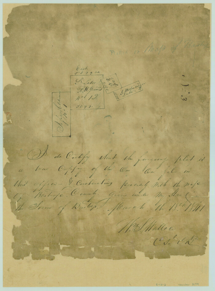
Print $2.00
- Digital $50.00
[Surveys in Bastrop County]
1841
Size: 11.3 x 8.4 inches
3179
Map of Bastrop District

Print $20.00
- Digital $50.00
Map of Bastrop District
1847
Size: 22.9 x 28.3 inches
3275
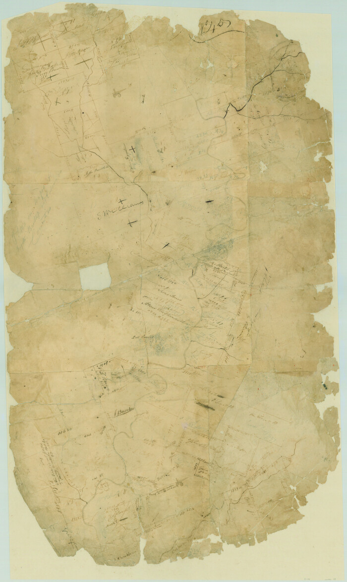
Bastrop County Sketch File 9
Print $40.00
- Digital $50.00
Bastrop County Sketch File 9
1943
-
Size
46.5 x 20.6 inches
-
Map/Doc
10320
-
Creation Date
1943
[Surveys near the city of Bastrop]
Print $2.00
- Digital $50.00
[Surveys near the city of Bastrop]
1841
-
Size
6.5 x 7.0 inches
-
Map/Doc
107
-
Creation Date
1841
Travis County Sketch File ABC
Print $20.00
- Digital $50.00
Travis County Sketch File ABC
-
Size
23.8 x 19.0 inches
-
Map/Doc
12480
Bastrop County Sketch File 1
Print $6.00
- Digital $50.00
Bastrop County Sketch File 1
1846
-
Size
8.1 x 9.8 inches
-
Map/Doc
14037
-
Creation Date
1846
Bastrop County Sketch File 1a
Print $4.00
- Digital $50.00
Bastrop County Sketch File 1a
-
Size
8.4 x 12.8 inches
-
Map/Doc
14040
Bastrop County Sketch File 2
Print $4.00
- Digital $50.00
Bastrop County Sketch File 2
1858
-
Size
10.8 x 8.3 inches
-
Map/Doc
14042
-
Creation Date
1858
Bastrop County Sketch File 3
Print $4.00
- Digital $50.00
Bastrop County Sketch File 3
1860
-
Size
8.9 x 9.2 inches
-
Map/Doc
14044
-
Creation Date
1860
Bastrop County Sketch File 4
Print $4.00
- Digital $50.00
Bastrop County Sketch File 4
1873
-
Size
12.7 x 7.9 inches
-
Map/Doc
14046
-
Creation Date
1873
Bastrop County Sketch File 5
Print $4.00
- Digital $50.00
Bastrop County Sketch File 5
-
Size
8.1 x 10.2 inches
-
Map/Doc
14048
Bastrop County Sketch File 6
Print $4.00
- Digital $50.00
Bastrop County Sketch File 6
1875
-
Size
8.8 x 7.8 inches
-
Map/Doc
14050
-
Creation Date
1875
Bastrop County Sketch File 7
Print $40.00
- Digital $50.00
Bastrop County Sketch File 7
-
Size
13.2 x 12.4 inches
-
Map/Doc
14052
Bastrop County Sketch File 8
Print $4.00
- Digital $50.00
Bastrop County Sketch File 8
-
Size
8.5 x 11.5 inches
-
Map/Doc
14054
Bastrop County Sketch File 10
Print $4.00
- Digital $50.00
Bastrop County Sketch File 10
1979
-
Size
14.3 x 8.8 inches
-
Map/Doc
14056
-
Creation Date
1979
Bastrop County Sketch File 11
Print $52.00
- Digital $50.00
Bastrop County Sketch File 11
-
Size
11.2 x 8.7 inches
-
Map/Doc
14058
Bastrop County Sketch File 12
Print $12.00
- Digital $50.00
Bastrop County Sketch File 12
1846
-
Size
12.8 x 8.4 inches
-
Map/Doc
14064
-
Creation Date
1846
Bastrop County Sketch File 13
Print $6.00
- Digital $50.00
Bastrop County Sketch File 13
1845
-
Size
10.1 x 15.8 inches
-
Map/Doc
14070
-
Creation Date
1845
[Surveys in Austin's Colony along the San Antonio Road and the Colorado River]
Print $20.00
- Digital $50.00
[Surveys in Austin's Colony along the San Antonio Road and the Colorado River]
1821
-
Size
17.3 x 25.6 inches
-
Map/Doc
15
-
Creation Date
1821
Bastrop County Boundary File 6
Print $40.00
- Digital $50.00
Bastrop County Boundary File 6
1923
-
Size
15.4 x 102.0 inches
-
Map/Doc
1691
-
Creation Date
1923
[Bastrop District]
Print $40.00
- Digital $50.00
[Bastrop District]
1838
-
Size
67.3 x 44.2 inches
-
Map/Doc
16941
-
Creation Date
1838
Bastrop Co.

Print $40.00
- Digital $50.00
Bastrop Co.
1955
-
Size
50.6 x 41.7 inches
-
Map/Doc
1778
-
Creation Date
1955
Surveys in Austin's Colony along the Colorado River below the San Antonio Road
Print $20.00
- Digital $50.00
Surveys in Austin's Colony along the Colorado River below the San Antonio Road
1830
-
Size
38.2 x 13.5 inches
-
Map/Doc
193
-
Creation Date
1830
[Surveys by Brown in Austin's Little Colony along the Colorado River and Walnut Creek]
Print $20.00
- Digital $50.00
[Surveys by Brown in Austin's Little Colony along the Colorado River and Walnut Creek]
1832
-
Size
33.2 x 23.3 inches
-
Map/Doc
196
-
Creation Date
1832
[Surveys in Austin's Colony along the Colorado River]
Print $20.00
- Digital $50.00
[Surveys in Austin's Colony along the Colorado River]
1830
-
Size
38.9 x 23.2 inches
-
Map/Doc
198
-
Creation Date
1830
[Traverse up the Brazos and Colorado River showing distance from county site to county site]
Print $40.00
- Digital $50.00
[Traverse up the Brazos and Colorado River showing distance from county site to county site]
1871
-
Size
16.2 x 98.8 inches
-
Map/Doc
2054
-
Creation Date
1871
Map of Austin's Li[ttle Colony Above the] San [Antonio Road]
Print $20.00
- Digital $50.00
Map of Austin's Li[ttle Colony Above the] San [Antonio Road]
1831
-
Size
14.2 x 19.3 inches
-
Map/Doc
215
-
Creation Date
1831
[Surveys in Milam's Colony between the Colorado River and northwest of the San Antonio Road]
Print $20.00
- Digital $50.00
[Surveys in Milam's Colony between the Colorado River and northwest of the San Antonio Road]
-
Size
22.0 x 27.4 inches
-
Map/Doc
29
Lee County Sketch File 9
Print $4.00
- Digital $50.00
Lee County Sketch File 9
-
Size
8.8 x 8.2 inches
-
Map/Doc
29709
[Bastrop District]
Print $40.00
- Digital $50.00
[Bastrop District]
1895
-
Size
36.5 x 52.0 inches
-
Map/Doc
3131
-
Creation Date
1895
[Surveys in Bastrop County]
Print $2.00
- Digital $50.00
[Surveys in Bastrop County]
1841
-
Size
11.3 x 8.4 inches
-
Map/Doc
3179
-
Creation Date
1841
Map of Bastrop District
Print $20.00
- Digital $50.00
Map of Bastrop District
1847
-
Size
22.9 x 28.3 inches
-
Map/Doc
3275
-
Creation Date
1847