Bastrop County Sketch File 1a

Print $4.00
- Digital $50.00
Bastrop County Sketch File 1a
Size: 8.4 x 12.8 inches
14040
Bastrop County Sketch File 5

Print $4.00
- Digital $50.00
Bastrop County Sketch File 5
Size: 8.1 x 10.2 inches
14048
Bastrop County Sketch File 7

Print $40.00
- Digital $50.00
Bastrop County Sketch File 7
Size: 13.2 x 12.4 inches
14052
Bastrop County Sketch File 8

Print $4.00
- Digital $50.00
Bastrop County Sketch File 8
Size: 8.5 x 11.5 inches
14054
Bastrop County Sketch File 11

Print $52.00
- Digital $50.00
Bastrop County Sketch File 11
Size: 11.2 x 8.7 inches
14058
[Surveys in Milam's Colony between the Colorado River and northwest of the San Antonio Road]
Print $20.00
- Digital $50.00
[Surveys in Milam's Colony between the Colorado River and northwest of the San Antonio Road]
Size: 22.0 x 27.4 inches
29
Lee County Sketch File 9

Print $4.00
- Digital $50.00
Lee County Sketch File 9
Size: 8.8 x 8.2 inches
29709
Caldwell County Sketch File 5

Print $8.00
- Digital $50.00
Caldwell County Sketch File 5
Size: 14.1 x 8.6 inches
35843
Bastrop County Boundary File 1

Print $4.00
- Digital $50.00
Bastrop County Boundary File 1
Size: 12.6 x 8.3 inches
50313
Bastrop County Boundary File 2

Print $12.00
- Digital $50.00
Bastrop County Boundary File 2
Size: 9.1 x 6.9 inches
50315
Bastrop County Boundary File 5

Print $18.00
- Digital $50.00
Bastrop County Boundary File 5
Size: 9.1 x 7.2 inches
50328
Bastrop County Boundary File 6

Print $20.00
- Digital $50.00
Bastrop County Boundary File 6
Size: 8.8 x 7.9 inches
50337
Bastrop County Rolled Sketch 1

Print $20.00
- Digital $50.00
Bastrop County Rolled Sketch 1
Size: 30.0 x 23.9 inches
5121
Bastrop County Rolled Sketch 1A

Print $20.00
- Digital $50.00
Bastrop County Rolled Sketch 1A
Size: 37.0 x 24.5 inches
5122
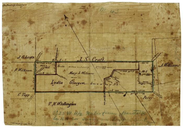
[Mary L. Williams or Lydia Glasgow Survey, Bastrop County, Texas]
Print $3.00
- Digital $50.00
[Mary L. Williams or Lydia Glasgow Survey, Bastrop County, Texas]
Size: 11.9 x 15.6 inches
572
Houston & Texas Central

Print $40.00
- Digital $50.00
Houston & Texas Central
Size: 24.1 x 56.4 inches
64797
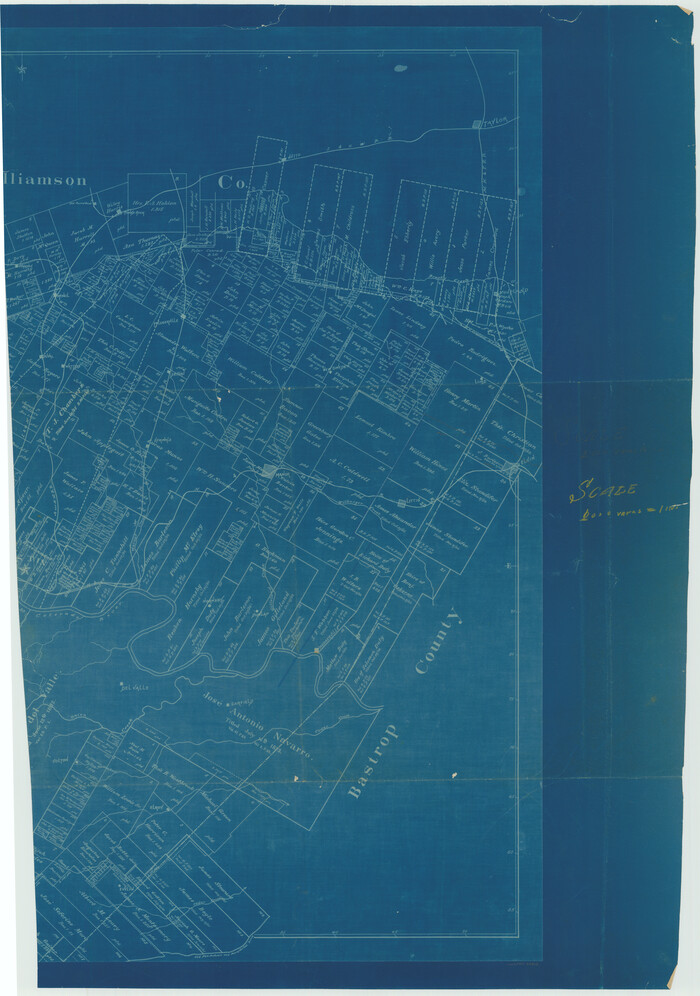
[East half of Travis County]
Print $20.00
- Digital $50.00
[East half of Travis County]
Size: 42.5 x 29.8 inches
75802
Map of Austin's Little Colony

Print $20.00
- Digital $50.00
Map of Austin's Little Colony
Size: 19.0 x 23.3 inches
76007
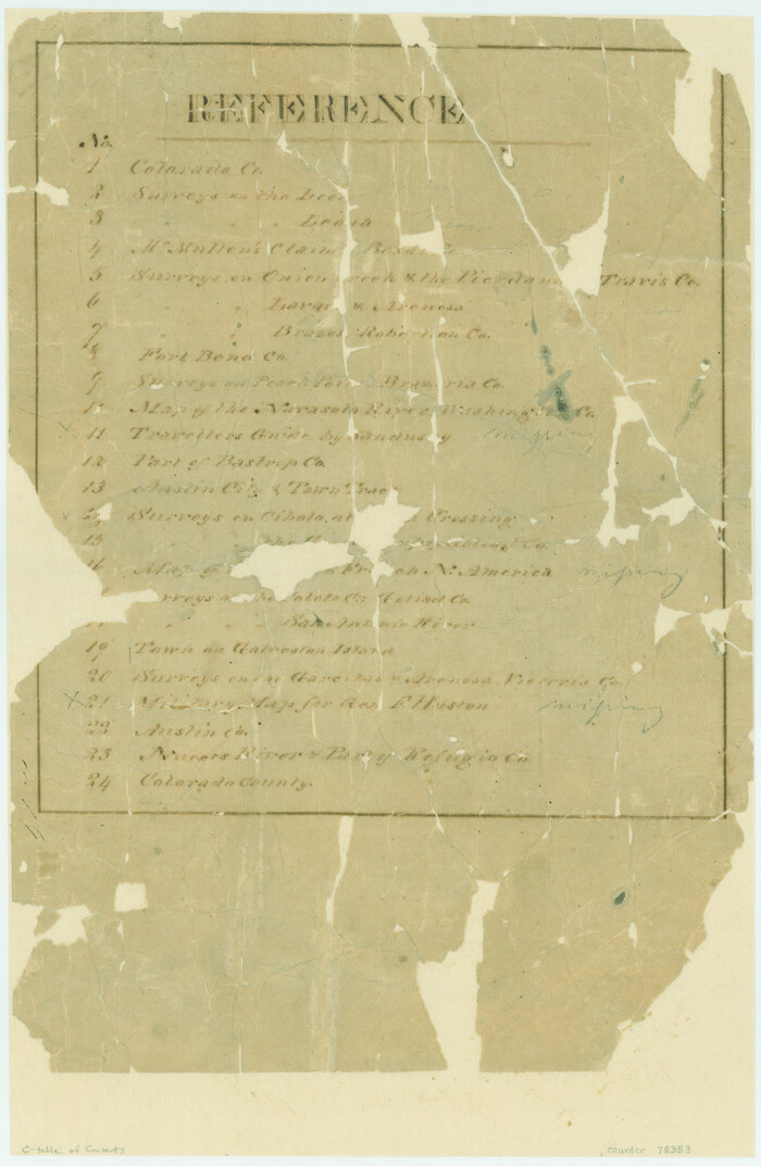
[Atlas C, Table of Contents]
Print $3.00
- Digital $50.00
[Atlas C, Table of Contents]
Size: 14.7 x 9.6 inches
78353
Revised Map of MacDade, Bastrop County, Texas

Print $20.00
- Digital $50.00
Revised Map of MacDade, Bastrop County, Texas
Size: 26.6 x 18.4 inches
78478
Bastrop County Rolled Sketch 3

Print $20.00
- Digital $50.00
Bastrop County Rolled Sketch 3
Size: 32.0 x 40.2 inches
8441
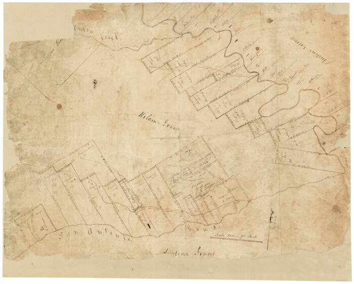
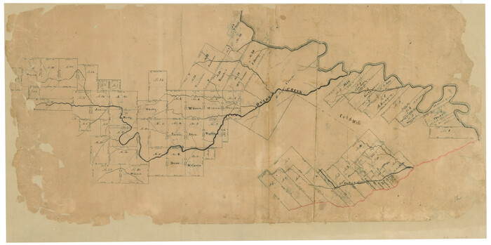
[Surveys in Milam's Colony along the Colorado River, Onion Creek, Cedar Creek, and north of the San Antonio Road]
Print $20.00
- Digital $50.00
[Surveys in Milam's Colony along the Colorado River, Onion Creek, Cedar Creek, and north of the San Antonio Road]
Size: 13.4 x 26.8 inches
88
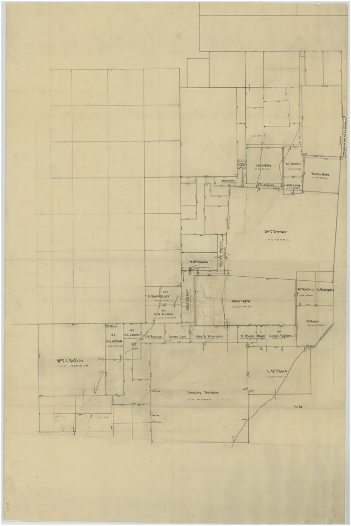
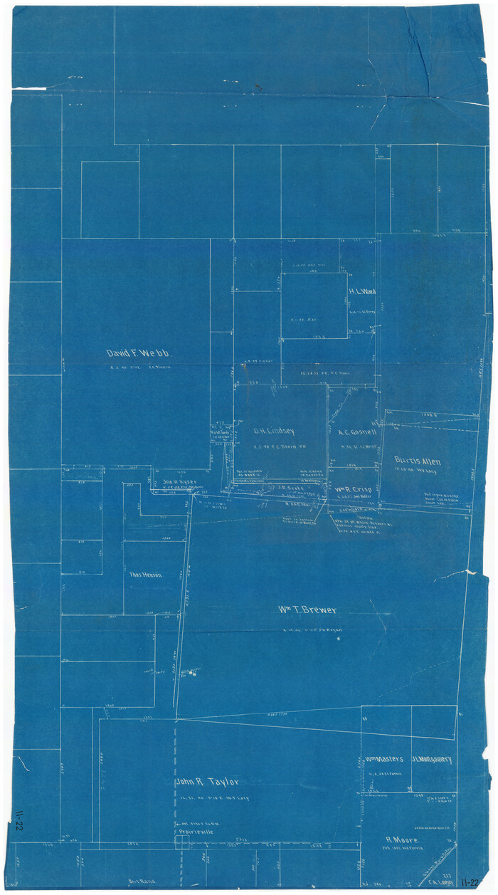
[Sketch Showing Wm. T. Brewer, John R. Taylor, Wm. F. Butler, Timothy DeVore, L. M. Thorn and adjoining surveys]
Print $40.00
- Digital $50.00
[Sketch Showing Wm. T. Brewer, John R. Taylor, Wm. F. Butler, Timothy DeVore, L. M. Thorn and adjoining surveys]
Size: 37.1 x 56.1 inches
89745
[Surveys along San Antonio Road]
Print $20.00
- Digital $50.00
[Surveys along San Antonio Road]
Size: 23.0 x 13.7 inches
90110
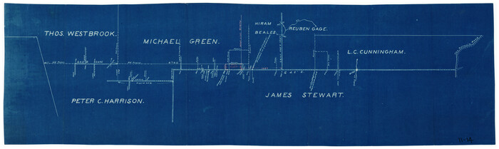
[Sketch showing North line of James Stewart survey and vicinity]
Print $20.00
- Digital $50.00
[Sketch showing North line of James Stewart survey and vicinity]
Size: 30.0 x 9.0 inches
90116
[Sketch Showing Wm. T. Brewer, John R. Taylor, Wm. F. Butler, Timothy DeVore, L. M. Thorn and adjoining surveys]
Print $20.00
- Digital $50.00
[Sketch Showing Wm. T. Brewer, John R. Taylor, Wm. F. Butler, Timothy DeVore, L. M. Thorn and adjoining surveys]
Size: 27.2 x 19.3 inches
90121
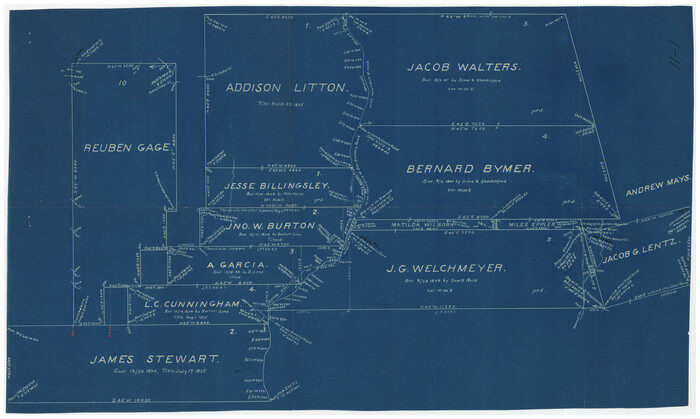
[Pencil sketch around J. Walters, J. G. Welchmeyer, R. Gage surveys]
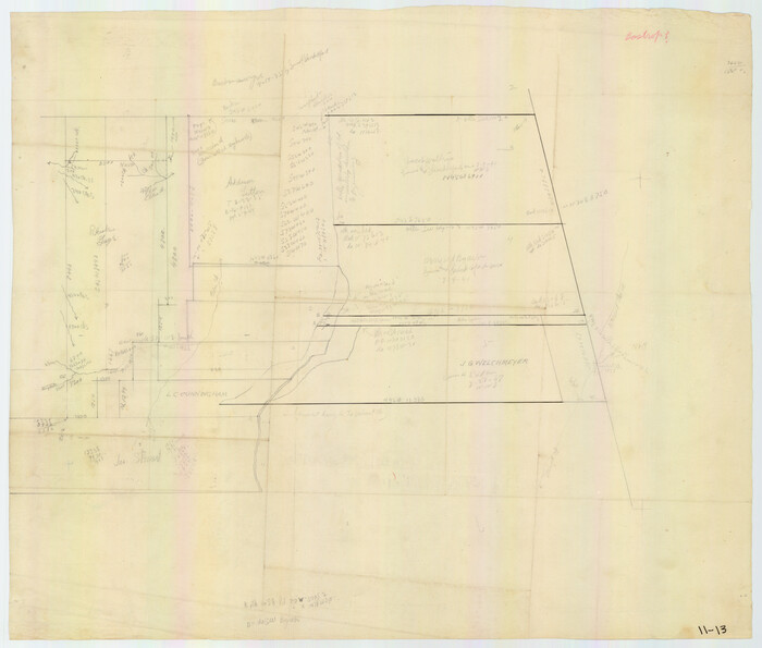
Print $20.00
- Digital $50.00
[Pencil sketch around J. Walters, J. G. Welchmeyer, R. Gage surveys]
Size: 25.5 x 21.7 inches
90206
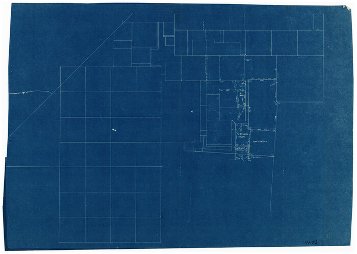
[Sketch Showing Wm. T. Brewer, John R. Taylor, Wm. F. Butler, Timothy DeVore, L. M. Thorn and adjoining surveys]
Print $20.00
- Digital $50.00
[Sketch Showing Wm. T. Brewer, John R. Taylor, Wm. F. Butler, Timothy DeVore, L. M. Thorn and adjoining surveys]
Size: 20.2 x 36.6 inches
90209
Bastrop County Sketch File 1a
Print $4.00
- Digital $50.00
Bastrop County Sketch File 1a
-
Size
8.4 x 12.8 inches
-
Map/Doc
14040
Bastrop County Sketch File 5
Print $4.00
- Digital $50.00
Bastrop County Sketch File 5
-
Size
8.1 x 10.2 inches
-
Map/Doc
14048
Bastrop County Sketch File 7
Print $40.00
- Digital $50.00
Bastrop County Sketch File 7
-
Size
13.2 x 12.4 inches
-
Map/Doc
14052
Bastrop County Sketch File 8
Print $4.00
- Digital $50.00
Bastrop County Sketch File 8
-
Size
8.5 x 11.5 inches
-
Map/Doc
14054
Bastrop County Sketch File 11
Print $52.00
- Digital $50.00
Bastrop County Sketch File 11
-
Size
11.2 x 8.7 inches
-
Map/Doc
14058
[Surveys in Milam's Colony between the Colorado River and northwest of the San Antonio Road]
Print $20.00
- Digital $50.00
[Surveys in Milam's Colony between the Colorado River and northwest of the San Antonio Road]
-
Size
22.0 x 27.4 inches
-
Map/Doc
29
Lee County Sketch File 9
Print $4.00
- Digital $50.00
Lee County Sketch File 9
-
Size
8.8 x 8.2 inches
-
Map/Doc
29709
Caldwell County Sketch File 5
Print $8.00
- Digital $50.00
Caldwell County Sketch File 5
-
Size
14.1 x 8.6 inches
-
Map/Doc
35843
Bastrop County Boundary File 1
Print $4.00
- Digital $50.00
Bastrop County Boundary File 1
-
Size
12.6 x 8.3 inches
-
Map/Doc
50313
Bastrop County Boundary File 2
Print $12.00
- Digital $50.00
Bastrop County Boundary File 2
-
Size
9.1 x 6.9 inches
-
Map/Doc
50315
Bastrop County Boundary File 5
Print $18.00
- Digital $50.00
Bastrop County Boundary File 5
-
Size
9.1 x 7.2 inches
-
Map/Doc
50328
Bastrop County Boundary File 6
Print $20.00
- Digital $50.00
Bastrop County Boundary File 6
-
Size
8.8 x 7.9 inches
-
Map/Doc
50337
Bastrop County Rolled Sketch 1
Print $20.00
- Digital $50.00
Bastrop County Rolled Sketch 1
-
Size
30.0 x 23.9 inches
-
Map/Doc
5121
Bastrop County Rolled Sketch 1A
Print $20.00
- Digital $50.00
Bastrop County Rolled Sketch 1A
-
Size
37.0 x 24.5 inches
-
Map/Doc
5122
[Mary L. Williams or Lydia Glasgow Survey, Bastrop County, Texas]
Print $3.00
- Digital $50.00
[Mary L. Williams or Lydia Glasgow Survey, Bastrop County, Texas]
-
Size
11.9 x 15.6 inches
-
Map/Doc
572
Houston & Texas Central
Print $40.00
- Digital $50.00
Houston & Texas Central
-
Size
24.1 x 56.4 inches
-
Map/Doc
64797
[East half of Travis County]
Print $20.00
- Digital $50.00
[East half of Travis County]
-
Size
42.5 x 29.8 inches
-
Map/Doc
75802
Map of Austin's Little Colony
Print $20.00
- Digital $50.00
Map of Austin's Little Colony
-
Size
19.0 x 23.3 inches
-
Map/Doc
76007
[Atlas C, Table of Contents]
Print $3.00
- Digital $50.00
[Atlas C, Table of Contents]
-
Size
14.7 x 9.6 inches
-
Map/Doc
78353
Revised Map of MacDade, Bastrop County, Texas
Print $20.00
- Digital $50.00
Revised Map of MacDade, Bastrop County, Texas
-
Size
26.6 x 18.4 inches
-
Map/Doc
78478
Bastrop County Rolled Sketch 3
Print $20.00
- Digital $50.00
Bastrop County Rolled Sketch 3
-
Size
32.0 x 40.2 inches
-
Map/Doc
8441
[Surveys in Milam's Colony along the Colorado River, Onion Creek, Cedar Creek, and north of the San Antonio Road]
Print $20.00
- Digital $50.00
[Surveys in Milam's Colony along the Colorado River, Onion Creek, Cedar Creek, and north of the San Antonio Road]
-
Size
13.4 x 26.8 inches
-
Map/Doc
88
Bastrop County Sketch File 9A

Print $40.00
- Digital $50.00
Bastrop County Sketch File 9A
-
Map/Doc
88484
[Sketch Showing Wm. T. Brewer, John R. Taylor, Wm. F. Butler, Timothy DeVore, L. M. Thorn and adjoining surveys]
Print $40.00
- Digital $50.00
[Sketch Showing Wm. T. Brewer, John R. Taylor, Wm. F. Butler, Timothy DeVore, L. M. Thorn and adjoining surveys]
-
Size
37.1 x 56.1 inches
-
Map/Doc
89745
[Surveys along San Antonio Road]
Print $20.00
- Digital $50.00
[Surveys along San Antonio Road]
-
Size
23.0 x 13.7 inches
-
Map/Doc
90110
[Sketch showing North line of James Stewart survey and vicinity]
Print $20.00
- Digital $50.00
[Sketch showing North line of James Stewart survey and vicinity]
-
Size
30.0 x 9.0 inches
-
Map/Doc
90116
Sec. 22, Block 103

Print $20.00
- Digital $50.00
Sec. 22, Block 103
-
Size
13.1 x 14.8 inches
-
Map/Doc
90120
[Sketch Showing Wm. T. Brewer, John R. Taylor, Wm. F. Butler, Timothy DeVore, L. M. Thorn and adjoining surveys]
Print $20.00
- Digital $50.00
[Sketch Showing Wm. T. Brewer, John R. Taylor, Wm. F. Butler, Timothy DeVore, L. M. Thorn and adjoining surveys]
-
Size
27.2 x 19.3 inches
-
Map/Doc
90121
[Pencil sketch around J. Walters, J. G. Welchmeyer, R. Gage surveys]
Print $20.00
- Digital $50.00
[Pencil sketch around J. Walters, J. G. Welchmeyer, R. Gage surveys]
-
Size
25.5 x 21.7 inches
-
Map/Doc
90206
[Sketch Showing Wm. T. Brewer, John R. Taylor, Wm. F. Butler, Timothy DeVore, L. M. Thorn and adjoining surveys]
Print $20.00
- Digital $50.00
[Sketch Showing Wm. T. Brewer, John R. Taylor, Wm. F. Butler, Timothy DeVore, L. M. Thorn and adjoining surveys]
-
Size
20.2 x 36.6 inches
-
Map/Doc
90209