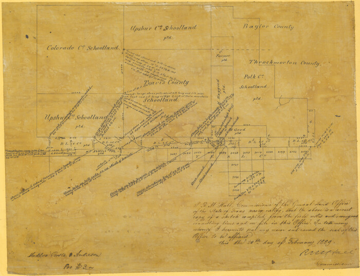
[Sketch showing County School Land surveys in Throckmorton and Baylor Counties, Texas]
Print $20.00
- Digital $50.00
[Sketch showing County School Land surveys in Throckmorton and Baylor Counties, Texas]
Size: 27.7 x 39.4 inches
75800
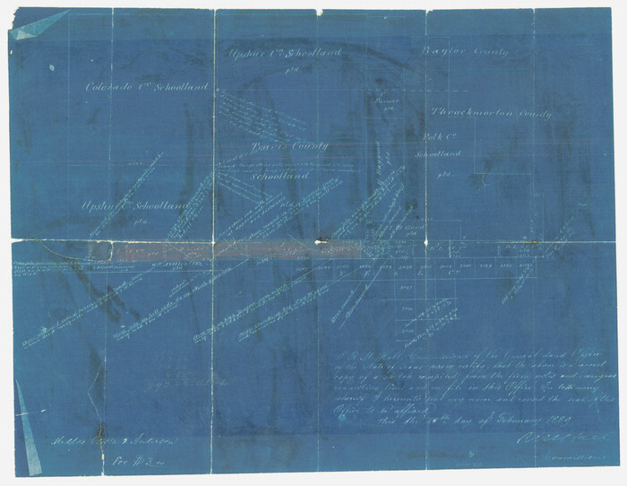
[Sketch showing County School Land Surveys in Throckmorton Counties, Texas]
Print $20.00
- Digital $50.00
[Sketch showing County School Land Surveys in Throckmorton Counties, Texas]
1889
Size: 15.9 x 20.2 inches
628
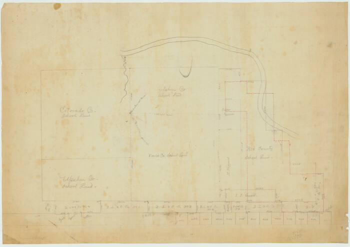
[Plat Showing Colorado, Upshur & Travis County School Land and Surrounding Area in Baylor & Throckmorton Counties, Texas]
Print $20.00
- Digital $50.00
[Plat Showing Colorado, Upshur & Travis County School Land and Surrounding Area in Baylor & Throckmorton Counties, Texas]
1889
Size: 15.8 x 20.5 inches
75790
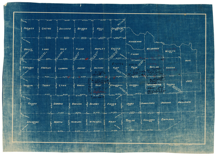
[Map of Counties South of Panhandle from Parmer to Childress in North to Andrews to Eastland in the South]
Print $3.00
- Digital $50.00
[Map of Counties South of Panhandle from Parmer to Childress in North to Andrews to Eastland in the South]
Size: 14.9 x 10.7 inches
92098
Working Sketch in Baylor and Throckmorton Cos.

Print $20.00
- Digital $50.00
Working Sketch in Baylor and Throckmorton Cos.
1890
Size: 24.2 x 20.8 inches
75771
Wilbarger County Sketch File 10

Print $20.00
- Digital $50.00
Wilbarger County Sketch File 10
1894
Size: 33.9 x 38.7 inches
10434
Water-Shed of the Brazos River

Print $40.00
- Digital $50.00
Water-Shed of the Brazos River
1925
Size: 35.0 x 88.0 inches
65263
Throckmorton County Working Sketch 1

Print $20.00
- Digital $50.00
Throckmorton County Working Sketch 1
1913
Size: 12.8 x 14.4 inches
62110
Throckmorton County Sketch File 12

Print $20.00
- Digital $50.00
Throckmorton County Sketch File 12
Size: 16.2 x 22.3 inches
12435
Throckmorton County Sketch File 10

Print $6.00
- Digital $50.00
Throckmorton County Sketch File 10
1955
Size: 11.2 x 8.8 inches
38102
Throckmorton County Rolled Sketch 1

Print $20.00
- Digital $50.00
Throckmorton County Rolled Sketch 1
1927
Size: 23.5 x 30.3 inches
7984
Sketch of Block B, GH & H RR & Blk C, CT RR Co, with surrounding & conflicting surveys in Knox & Baylor Counties

Print $20.00
- Digital $50.00
Sketch of Block B, GH & H RR & Blk C, CT RR Co, with surrounding & conflicting surveys in Knox & Baylor Counties
Size: 24.9 x 17.9 inches
75784
Seymour, Baylor County, Texas

Print $20.00
Seymour, Baylor County, Texas
1890
Size: 15.4 x 24.2 inches
89207
S. M. S. Throckmorton Ranch, Throckmorton, Haskell, Baylor Cos.

Print $20.00
- Digital $50.00
S. M. S. Throckmorton Ranch, Throckmorton, Haskell, Baylor Cos.
1955
Size: 33.8 x 45.1 inches
2104
Map of the Surveyed Part of Young District

Print $40.00
- Digital $50.00
Map of the Surveyed Part of Young District
1860
Size: 56.2 x 54.7 inches
1986
Map of the Surveyed Part of Young District

Print $40.00
- Digital $50.00
Map of the Surveyed Part of Young District
1860
Size: 56.3 x 32.6 inches
87373
Map of the Surveyed Part of Young District

Print $40.00
- Digital $50.00
Map of the Surveyed Part of Young District
1860
Size: 56.3 x 27.3 inches
87374
Map of the Fort Worth and Denver City Railway

Print $40.00
- Digital $50.00
Map of the Fort Worth and Denver City Railway
1873
Size: 31.6 x 90.3 inches
64778
Map of Baylor County Young Land District, formely Fannin District

Print $20.00
- Digital $50.00
Map of Baylor County Young Land District, formely Fannin District
1859
Size: 25.8 x 20.0 inches
3281
Map of Baylor County

Print $20.00
- Digital $50.00
Map of Baylor County
1885
Size: 24.9 x 18.9 inches
3284
Map of Baylor County

Print $20.00
- Digital $50.00
Map of Baylor County
1895
Size: 47.4 x 37.0 inches
4882
Knox County Sketch File 8

Print $26.00
- Digital $50.00
Knox County Sketch File 8
1882
Size: 8.6 x 7.8 inches
29218
Knox County Sketch File 26

Print $40.00
- Digital $50.00
Knox County Sketch File 26
1957
Size: 17.3 x 14.4 inches
29262
Knox County Sketch File 25

Print $10.00
- Digital $50.00
Knox County Sketch File 25
1872
Size: 12.8 x 8.2 inches
29257
Knox County Sketch File 23

Print $20.00
- Digital $50.00
Knox County Sketch File 23
1931
Size: 21.4 x 15.3 inches
11963
Knox County Sketch File 2

Print $40.00
- Digital $50.00
Knox County Sketch File 2
1872
Size: 26.5 x 38.0 inches
76758
Knox County Sketch File 12

Print $13.00
- Digital $50.00
Knox County Sketch File 12
1889
Size: 9.8 x 8.5 inches
29225
Knox County Sketch File 1-1a

Print $30.00
- Digital $50.00
Knox County Sketch File 1-1a
1872
Size: 8.2 x 12.4 inches
29212
Knox County Rolled Sketch 9

Print $20.00
- Digital $50.00
Knox County Rolled Sketch 9
Size: 26.1 x 33.0 inches
9407
Knox County Rolled Sketch 8

Print $20.00
- Digital $50.00
Knox County Rolled Sketch 8
Size: 28.2 x 32.5 inches
9406
[Sketch showing County School Land surveys in Throckmorton and Baylor Counties, Texas]
Print $20.00
- Digital $50.00
[Sketch showing County School Land surveys in Throckmorton and Baylor Counties, Texas]
-
Size
27.7 x 39.4 inches
-
Map/Doc
75800
[Sketch showing County School Land Surveys in Throckmorton Counties, Texas]
Print $20.00
- Digital $50.00
[Sketch showing County School Land Surveys in Throckmorton Counties, Texas]
1889
-
Size
15.9 x 20.2 inches
-
Map/Doc
628
-
Creation Date
1889
[Plat Showing Colorado, Upshur & Travis County School Land and Surrounding Area in Baylor & Throckmorton Counties, Texas]
Print $20.00
- Digital $50.00
[Plat Showing Colorado, Upshur & Travis County School Land and Surrounding Area in Baylor & Throckmorton Counties, Texas]
1889
-
Size
15.8 x 20.5 inches
-
Map/Doc
75790
-
Creation Date
1889
[Map of Counties South of Panhandle from Parmer to Childress in North to Andrews to Eastland in the South]
Print $3.00
- Digital $50.00
[Map of Counties South of Panhandle from Parmer to Childress in North to Andrews to Eastland in the South]
-
Size
14.9 x 10.7 inches
-
Map/Doc
92098
Working Sketch in Baylor and Throckmorton Cos.
Print $20.00
- Digital $50.00
Working Sketch in Baylor and Throckmorton Cos.
1890
-
Size
24.2 x 20.8 inches
-
Map/Doc
75771
-
Creation Date
1890
Wilbarger County Sketch File 10
Print $20.00
- Digital $50.00
Wilbarger County Sketch File 10
1894
-
Size
33.9 x 38.7 inches
-
Map/Doc
10434
-
Creation Date
1894
Water-Shed of the Brazos River
Print $40.00
- Digital $50.00
Water-Shed of the Brazos River
1925
-
Size
35.0 x 88.0 inches
-
Map/Doc
65263
-
Creation Date
1925
Throckmorton County Working Sketch 1
Print $20.00
- Digital $50.00
Throckmorton County Working Sketch 1
1913
-
Size
12.8 x 14.4 inches
-
Map/Doc
62110
-
Creation Date
1913
Throckmorton County Sketch File 12
Print $20.00
- Digital $50.00
Throckmorton County Sketch File 12
-
Size
16.2 x 22.3 inches
-
Map/Doc
12435
Throckmorton County Sketch File 10
Print $6.00
- Digital $50.00
Throckmorton County Sketch File 10
1955
-
Size
11.2 x 8.8 inches
-
Map/Doc
38102
-
Creation Date
1955
Throckmorton County Rolled Sketch 1
Print $20.00
- Digital $50.00
Throckmorton County Rolled Sketch 1
1927
-
Size
23.5 x 30.3 inches
-
Map/Doc
7984
-
Creation Date
1927
Sketch of Block B, GH & H RR & Blk C, CT RR Co, with surrounding & conflicting surveys in Knox & Baylor Counties
Print $20.00
- Digital $50.00
Sketch of Block B, GH & H RR & Blk C, CT RR Co, with surrounding & conflicting surveys in Knox & Baylor Counties
-
Size
24.9 x 17.9 inches
-
Map/Doc
75784
Seymour, Baylor County, Texas
Print $20.00
Seymour, Baylor County, Texas
1890
-
Size
15.4 x 24.2 inches
-
Map/Doc
89207
-
Creation Date
1890
S. M. S. Throckmorton Ranch, Throckmorton, Haskell, Baylor Cos.
Print $20.00
- Digital $50.00
S. M. S. Throckmorton Ranch, Throckmorton, Haskell, Baylor Cos.
1955
-
Size
33.8 x 45.1 inches
-
Map/Doc
2104
-
Creation Date
1955
Map of the Surveyed Part of Young District
Print $40.00
- Digital $50.00
Map of the Surveyed Part of Young District
1860
-
Size
56.2 x 54.7 inches
-
Map/Doc
1986
-
Creation Date
1860
Map of the Surveyed Part of Young District
Print $40.00
- Digital $50.00
Map of the Surveyed Part of Young District
1860
-
Size
56.3 x 32.6 inches
-
Map/Doc
87373
-
Creation Date
1860
Map of the Surveyed Part of Young District
Print $40.00
- Digital $50.00
Map of the Surveyed Part of Young District
1860
-
Size
56.3 x 27.3 inches
-
Map/Doc
87374
-
Creation Date
1860
Map of the Fort Worth and Denver City Railway
Print $40.00
- Digital $50.00
Map of the Fort Worth and Denver City Railway
1873
-
Size
31.6 x 90.3 inches
-
Map/Doc
64778
-
Creation Date
1873
Map of Baylor County Young Land District, formely Fannin District
Print $20.00
- Digital $50.00
Map of Baylor County Young Land District, formely Fannin District
1859
-
Size
25.8 x 20.0 inches
-
Map/Doc
3281
-
Creation Date
1859
Map of Baylor County
Print $20.00
- Digital $50.00
Map of Baylor County
1885
-
Size
24.9 x 18.9 inches
-
Map/Doc
3284
-
Creation Date
1885
Map of Baylor County
Print $20.00
- Digital $50.00
Map of Baylor County
1895
-
Size
47.4 x 37.0 inches
-
Map/Doc
4882
-
Creation Date
1895
Knox County Sketch File 8
Print $26.00
- Digital $50.00
Knox County Sketch File 8
1882
-
Size
8.6 x 7.8 inches
-
Map/Doc
29218
-
Creation Date
1882
Knox County Sketch File 26
Print $40.00
- Digital $50.00
Knox County Sketch File 26
1957
-
Size
17.3 x 14.4 inches
-
Map/Doc
29262
-
Creation Date
1957
Knox County Sketch File 25
Print $10.00
- Digital $50.00
Knox County Sketch File 25
1872
-
Size
12.8 x 8.2 inches
-
Map/Doc
29257
-
Creation Date
1872
Knox County Sketch File 23
Print $20.00
- Digital $50.00
Knox County Sketch File 23
1931
-
Size
21.4 x 15.3 inches
-
Map/Doc
11963
-
Creation Date
1931
Knox County Sketch File 2
Print $40.00
- Digital $50.00
Knox County Sketch File 2
1872
-
Size
26.5 x 38.0 inches
-
Map/Doc
76758
-
Creation Date
1872
Knox County Sketch File 12
Print $13.00
- Digital $50.00
Knox County Sketch File 12
1889
-
Size
9.8 x 8.5 inches
-
Map/Doc
29225
-
Creation Date
1889
Knox County Sketch File 1-1a
Print $30.00
- Digital $50.00
Knox County Sketch File 1-1a
1872
-
Size
8.2 x 12.4 inches
-
Map/Doc
29212
-
Creation Date
1872
Knox County Rolled Sketch 9
Print $20.00
- Digital $50.00
Knox County Rolled Sketch 9
-
Size
26.1 x 33.0 inches
-
Map/Doc
9407
Knox County Rolled Sketch 8
Print $20.00
- Digital $50.00
Knox County Rolled Sketch 8
-
Size
28.2 x 32.5 inches
-
Map/Doc
9406