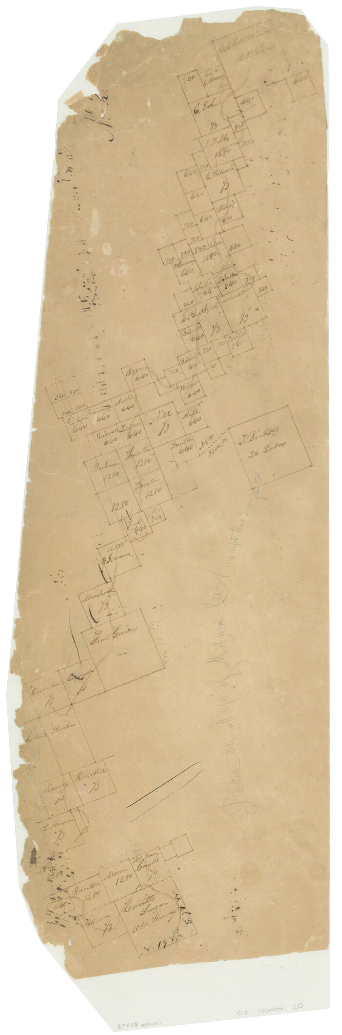
Bosque County Sketch File 32

Print $42.00
- Digital $50.00
Bosque County Sketch File 32
1944
Size: 19.6 x 18.6 inches
10938
Comanche County Sketch File 21

Print $20.00
- Digital $50.00
Comanche County Sketch File 21
Size: 18.3 x 20.2 inches
11143
Comanche County Sketch File 26

Print $20.00
- Digital $50.00
Comanche County Sketch File 26
Size: 18.0 x 17.5 inches
11144
Coryell County Sketch File 12

Print $20.00
- Digital $50.00
Coryell County Sketch File 12
1863
Size: 21.7 x 19.3 inches
11181
Coryell County Sketch File 20

Print $20.00
- Digital $50.00
Coryell County Sketch File 20
Size: 25.8 x 20.1 inches
11183
Hamilton County Sketch File 16

Print $20.00
- Digital $50.00
Hamilton County Sketch File 16
1898
Size: 22.6 x 19.6 inches
11616
Hamilton County Sketch File 23

Print $20.00
- Digital $50.00
Hamilton County Sketch File 23
1955
Size: 25.8 x 24.8 inches
11618
Hamilton County Sketch File 24

Print $20.00
- Digital $50.00
Hamilton County Sketch File 24
1953
Size: 23.2 x 22.8 inches
11619
Mills County Sketch File 24

Print $20.00
- Digital $50.00
Mills County Sketch File 24
Size: 19.2 x 21.0 inches
12094
Bosque County Sketch File 6

Print $4.00
- Digital $50.00
Bosque County Sketch File 6
1851
Size: 12.1 x 7.6 inches
14748
Hamilton County Map

Print $40.00
- Digital $50.00
Hamilton County Map
1887
Size: 38.2 x 54.4 inches
16844
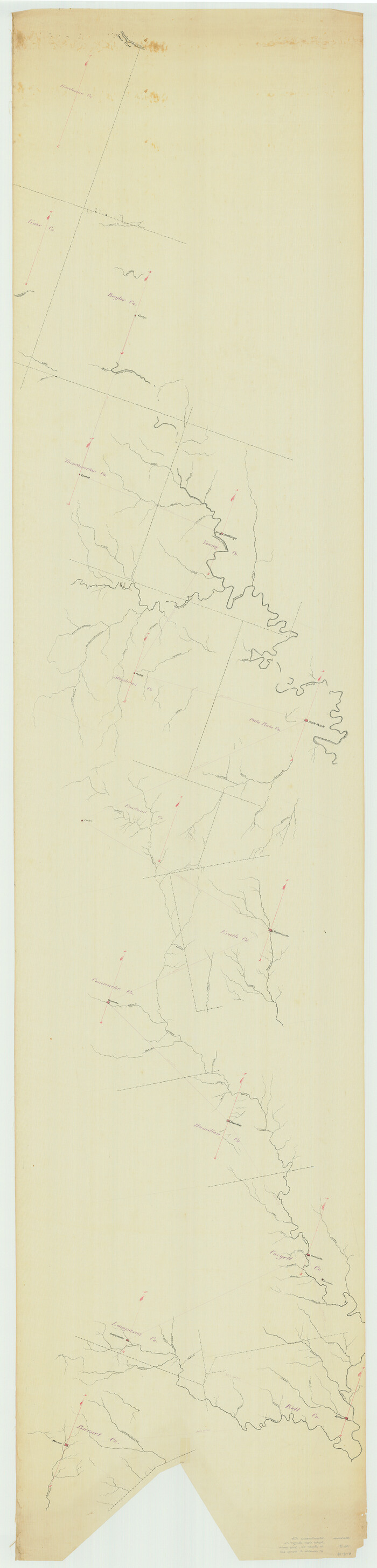
[Sketch from Burnet Co. to Baylor Co. tying center of counties to county site]
Print $40.00
- Digital $50.00
[Sketch from Burnet Co. to Baylor Co. tying center of counties to county site]
1900
Size: 132.6 x 31.9 inches
1699
Comanche County Sketch File 1

Print $6.00
- Digital $50.00
Comanche County Sketch File 1
1847
Size: 15.4 x 11.8 inches
19051
Comanche County Sketch File 3

Print $40.00
- Digital $50.00
Comanche County Sketch File 3
1847
Size: 14.8 x 15.6 inches
19055
Comanche County Sketch File 5

Print $4.00
- Digital $50.00
Comanche County Sketch File 5
1848
Size: 8.6 x 8.3 inches
19059
Comanche County Sketch File 12

Print $4.00
- Digital $50.00
Comanche County Sketch File 12
1859
Size: 8.5 x 15.2 inches
19074
Comanche County Sketch File 18

Print $4.00
- Digital $50.00
Comanche County Sketch File 18
Size: 8.4 x 7.8 inches
19091
Comanche County Sketch File 23

Print $4.00
- Digital $50.00
Comanche County Sketch File 23
Size: 8.3 x 7.5 inches
19111
Coryell County Sketch File 4

Print $6.00
- Digital $50.00
Coryell County Sketch File 4
1854
Size: 12.8 x 8.2 inches
19342
Coryell County Sketch File 5

Print $40.00
- Digital $50.00
Coryell County Sketch File 5
1858
Size: 16.0 x 12.7 inches
19345
Coryell County Sketch File 10

Print $6.00
- Digital $50.00
Coryell County Sketch File 10
1861
Size: 8.6 x 7.2 inches
19361
Coryell County Sketch File 11

Print $4.00
- Digital $50.00
Coryell County Sketch File 11
Size: 8.7 x 11.7 inches
19364
[Surveys along the Leon River]
Print $20.00
- Digital $50.00
[Surveys along the Leon River]
1840
Size: 20.3 x 6.6 inches
20
Hamilton County Sketch File 1

Print $4.00
- Digital $50.00
Hamilton County Sketch File 1
Size: 12.5 x 8.2 inches
24897
Hamilton County Sketch File 2

Print $4.00
- Digital $50.00
Hamilton County Sketch File 2
1854
Size: 12.2 x 7.9 inches
24899
Hamilton County Sketch File 3

Print $4.00
- Digital $50.00
Hamilton County Sketch File 3
1852
Size: 12.7 x 8.0 inches
24901
Hamilton County Sketch File 4

Print $16.00
- Digital $50.00
Hamilton County Sketch File 4
Size: 14.5 x 9.1 inches
24903
Hamilton County Sketch File 5

Print $4.00
- Digital $50.00
Hamilton County Sketch File 5
Size: 10.2 x 8.1 inches
24908
Hamilton County Sketch File 7

Print $40.00
- Digital $50.00
Hamilton County Sketch File 7
1860
Size: 12.2 x 15.3 inches
24912
Hamilton County Sketch File 8

Print $4.00
- Digital $50.00
Hamilton County Sketch File 8
1860
Size: 12.2 x 8.0 inches
24914
Bosque County Sketch File 32
Print $42.00
- Digital $50.00
Bosque County Sketch File 32
1944
-
Size
19.6 x 18.6 inches
-
Map/Doc
10938
-
Creation Date
1944
Comanche County Sketch File 21
Print $20.00
- Digital $50.00
Comanche County Sketch File 21
-
Size
18.3 x 20.2 inches
-
Map/Doc
11143
Comanche County Sketch File 26
Print $20.00
- Digital $50.00
Comanche County Sketch File 26
-
Size
18.0 x 17.5 inches
-
Map/Doc
11144
Coryell County Sketch File 12
Print $20.00
- Digital $50.00
Coryell County Sketch File 12
1863
-
Size
21.7 x 19.3 inches
-
Map/Doc
11181
-
Creation Date
1863
Coryell County Sketch File 20
Print $20.00
- Digital $50.00
Coryell County Sketch File 20
-
Size
25.8 x 20.1 inches
-
Map/Doc
11183
Hamilton County Sketch File 16
Print $20.00
- Digital $50.00
Hamilton County Sketch File 16
1898
-
Size
22.6 x 19.6 inches
-
Map/Doc
11616
-
Creation Date
1898
Hamilton County Sketch File 23
Print $20.00
- Digital $50.00
Hamilton County Sketch File 23
1955
-
Size
25.8 x 24.8 inches
-
Map/Doc
11618
-
Creation Date
1955
Hamilton County Sketch File 24
Print $20.00
- Digital $50.00
Hamilton County Sketch File 24
1953
-
Size
23.2 x 22.8 inches
-
Map/Doc
11619
-
Creation Date
1953
Mills County Sketch File 24
Print $20.00
- Digital $50.00
Mills County Sketch File 24
-
Size
19.2 x 21.0 inches
-
Map/Doc
12094
Bosque County Sketch File 6
Print $4.00
- Digital $50.00
Bosque County Sketch File 6
1851
-
Size
12.1 x 7.6 inches
-
Map/Doc
14748
-
Creation Date
1851
Hamilton County Map
Print $40.00
- Digital $50.00
Hamilton County Map
1887
-
Size
38.2 x 54.4 inches
-
Map/Doc
16844
-
Creation Date
1887
[Sketch from Burnet Co. to Baylor Co. tying center of counties to county site]
Print $40.00
- Digital $50.00
[Sketch from Burnet Co. to Baylor Co. tying center of counties to county site]
1900
-
Size
132.6 x 31.9 inches
-
Map/Doc
1699
-
Creation Date
1900
Comanche County Sketch File 1
Print $6.00
- Digital $50.00
Comanche County Sketch File 1
1847
-
Size
15.4 x 11.8 inches
-
Map/Doc
19051
-
Creation Date
1847
Comanche County Sketch File 3
Print $40.00
- Digital $50.00
Comanche County Sketch File 3
1847
-
Size
14.8 x 15.6 inches
-
Map/Doc
19055
-
Creation Date
1847
Comanche County Sketch File 5
Print $4.00
- Digital $50.00
Comanche County Sketch File 5
1848
-
Size
8.6 x 8.3 inches
-
Map/Doc
19059
-
Creation Date
1848
Comanche County Sketch File 12
Print $4.00
- Digital $50.00
Comanche County Sketch File 12
1859
-
Size
8.5 x 15.2 inches
-
Map/Doc
19074
-
Creation Date
1859
Comanche County Sketch File 18
Print $4.00
- Digital $50.00
Comanche County Sketch File 18
-
Size
8.4 x 7.8 inches
-
Map/Doc
19091
Comanche County Sketch File 23
Print $4.00
- Digital $50.00
Comanche County Sketch File 23
-
Size
8.3 x 7.5 inches
-
Map/Doc
19111
Coryell County Sketch File 4
Print $6.00
- Digital $50.00
Coryell County Sketch File 4
1854
-
Size
12.8 x 8.2 inches
-
Map/Doc
19342
-
Creation Date
1854
Coryell County Sketch File 5
Print $40.00
- Digital $50.00
Coryell County Sketch File 5
1858
-
Size
16.0 x 12.7 inches
-
Map/Doc
19345
-
Creation Date
1858
Coryell County Sketch File 10
Print $6.00
- Digital $50.00
Coryell County Sketch File 10
1861
-
Size
8.6 x 7.2 inches
-
Map/Doc
19361
-
Creation Date
1861
Coryell County Sketch File 11
Print $4.00
- Digital $50.00
Coryell County Sketch File 11
-
Size
8.7 x 11.7 inches
-
Map/Doc
19364
[Surveys along the Leon River]
Print $20.00
- Digital $50.00
[Surveys along the Leon River]
1840
-
Size
20.3 x 6.6 inches
-
Map/Doc
20
-
Creation Date
1840
Hamilton County Sketch File 1
Print $4.00
- Digital $50.00
Hamilton County Sketch File 1
-
Size
12.5 x 8.2 inches
-
Map/Doc
24897
Hamilton County Sketch File 2
Print $4.00
- Digital $50.00
Hamilton County Sketch File 2
1854
-
Size
12.2 x 7.9 inches
-
Map/Doc
24899
-
Creation Date
1854
Hamilton County Sketch File 3
Print $4.00
- Digital $50.00
Hamilton County Sketch File 3
1852
-
Size
12.7 x 8.0 inches
-
Map/Doc
24901
-
Creation Date
1852
Hamilton County Sketch File 4
Print $16.00
- Digital $50.00
Hamilton County Sketch File 4
-
Size
14.5 x 9.1 inches
-
Map/Doc
24903
Hamilton County Sketch File 5
Print $4.00
- Digital $50.00
Hamilton County Sketch File 5
-
Size
10.2 x 8.1 inches
-
Map/Doc
24908
Hamilton County Sketch File 7
Print $40.00
- Digital $50.00
Hamilton County Sketch File 7
1860
-
Size
12.2 x 15.3 inches
-
Map/Doc
24912
-
Creation Date
1860
Hamilton County Sketch File 8
Print $4.00
- Digital $50.00
Hamilton County Sketch File 8
1860
-
Size
12.2 x 8.0 inches
-
Map/Doc
24914
-
Creation Date
1860