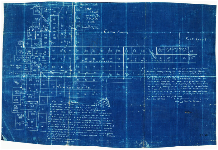
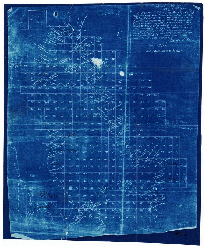
[Sketch showing parts of H. & G. N. RR. Co. Blocks 7 and 8, K. Aycock Block 4, G. H. & H. RR. Co. Block 5 and various surveys west]
Print $20.00
- Digital $50.00
[Sketch showing parts of H. & G. N. RR. Co. Blocks 7 and 8, K. Aycock Block 4, G. H. & H. RR. Co. Block 5 and various surveys west]
1902
Size: 25.5 x 17.3 inches
90871
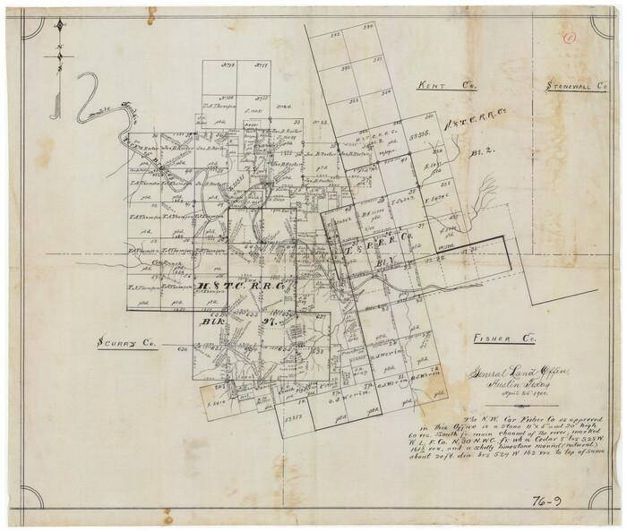
[Sketch showing Northwest corner of Fisher County, Northeast corner of Scurry County and South part of Kent County]
Print $20.00
- Digital $50.00
[Sketch showing Northwest corner of Fisher County, Northeast corner of Scurry County and South part of Kent County]
1900
Size: 17.7 x 15.0 inches
90917
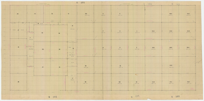
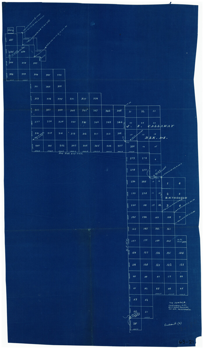
[S51-58, 27, 30, 303-306, 221-224, 562, 564]
Print $20.00
- Digital $50.00
[S51-58, 27, 30, 303-306, 221-224, 562, 564]
Size: 31.1 x 15.6 inches
92185
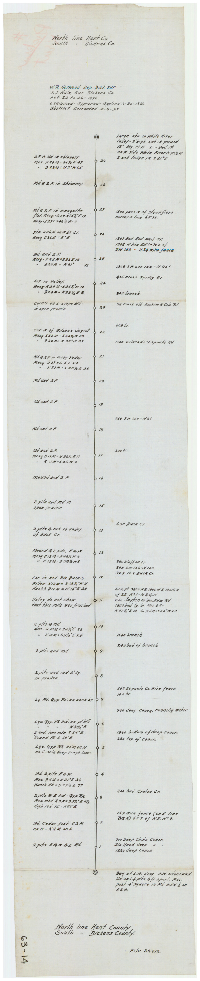
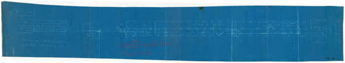
[North Line of Kent County/South Line of Dickens County]
Print $20.00
- Digital $50.00
[North Line of Kent County/South Line of Dickens County]
1892
Size: 8.4 x 38.1 inches
90937
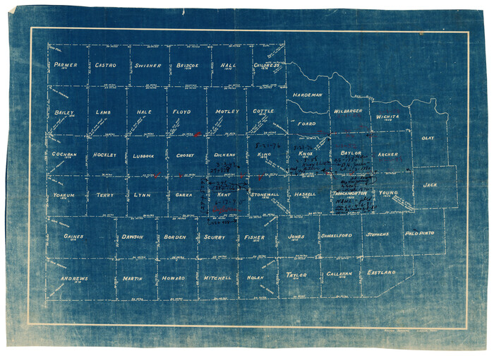
[Map of Counties South of Panhandle from Parmer to Childress in North to Andrews to Eastland in the South]
Print $3.00
- Digital $50.00
[Map of Counties South of Panhandle from Parmer to Childress in North to Andrews to Eastland in the South]
Size: 14.9 x 10.7 inches
92098
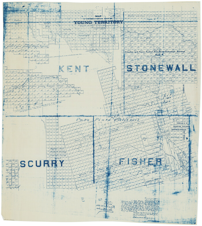
[Map of Block 97, Borden and Scurry Co (Exhibit A); Map of Southeastern part of Young Territory; Map of part of of Borden, Fisher, Kent, Mitchell, Scurry and Garza Cos. Showing the north boundary line of the T&P 80 mile reservation]
Print $20.00
- Digital $50.00
[Map of Block 97, Borden and Scurry Co (Exhibit A); Map of Southeastern part of Young Territory; Map of part of of Borden, Fisher, Kent, Mitchell, Scurry and Garza Cos. Showing the north boundary line of the T&P 80 mile reservation]
1873
Size: 33.4 x 29.6 inches
65692
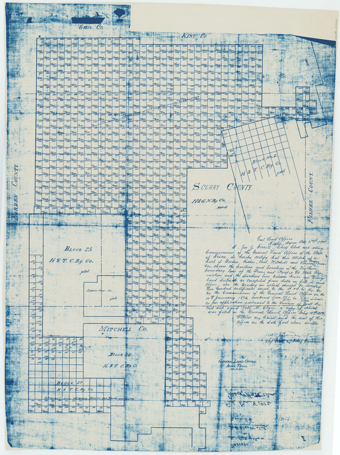
[Map of Block 97, Borden and Scurry Co (Exhibit A); Map of Southeastern part of Young Territory; Map of part of of Borden, Fisher, Kent, Mitchell, Scurry and Garza Cos. Showing the north boundary line of the T&P 80 mile reservation]
Print $20.00
- Digital $50.00
[Map of Block 97, Borden and Scurry Co (Exhibit A); Map of Southeastern part of Young Territory; Map of part of of Borden, Fisher, Kent, Mitchell, Scurry and Garza Cos. Showing the north boundary line of the T&P 80 mile reservation]
1901
Size: 31.2 x 23.3 inches
65693
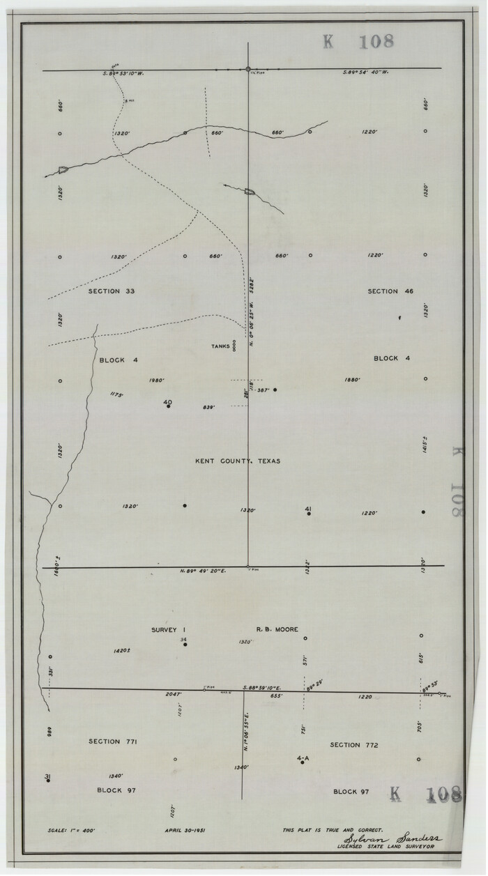
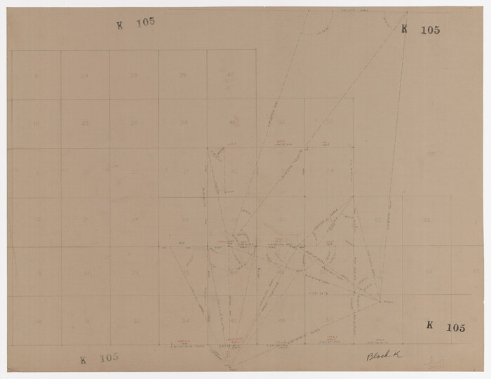
[Kent County Block 4, Sections 33 and 46, Block 97, Sections 771 and 772]
Print $2.00
- Digital $50.00
[Kent County Block 4, Sections 33 and 46, Block 97, Sections 771 and 772]
1951
Size: 8.7 x 15.6 inches
92192
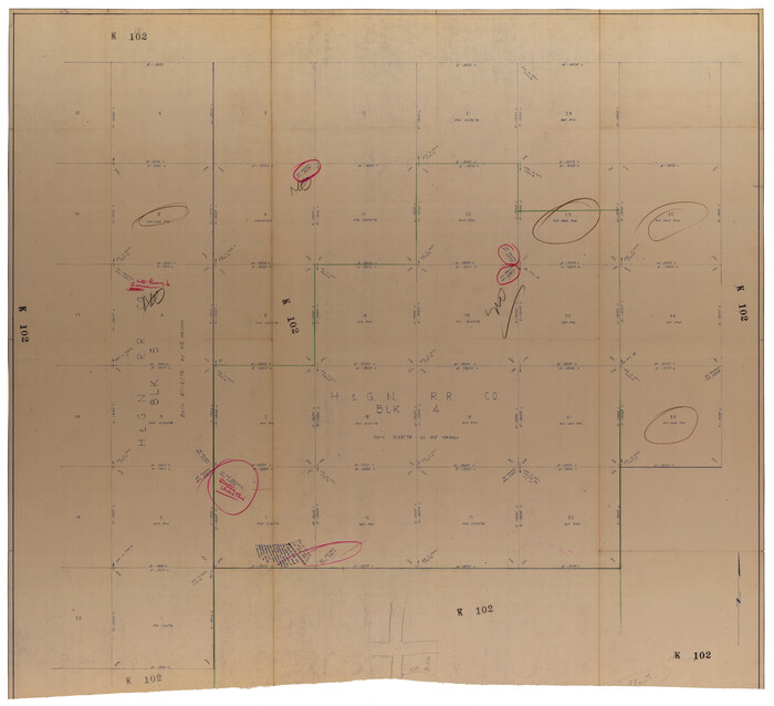
[H. & G.N. RR. Co. Block 4 and vicinity]
Print $20.00
- Digital $50.00
[H. & G.N. RR. Co. Block 4 and vicinity]
Size: 40.8 x 37.4 inches
92160
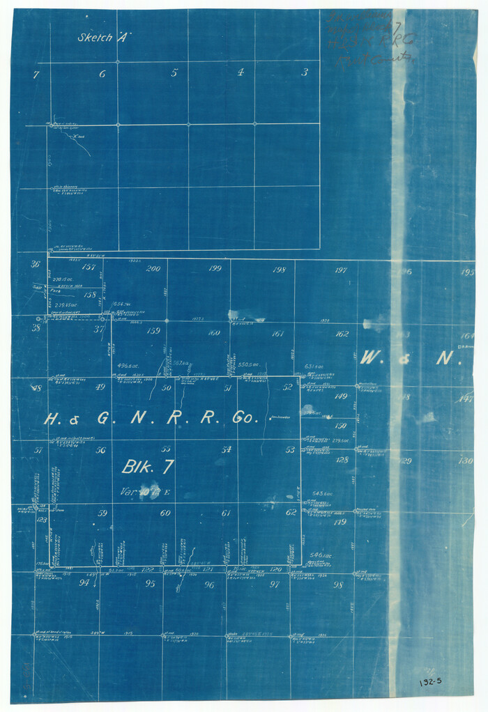
[H. & G. N. RR. Company, Block 7]
Print $20.00
- Digital $50.00
[H. & G. N. RR. Company, Block 7]
Size: 14.7 x 21.4 inches
91018
[H. & G. N. RR. Co. Block 1]
Print $20.00
- Digital $50.00
[H. & G. N. RR. Co. Block 1]
Size: 17.1 x 28.0 inches
90890
[H. & G. N. Block 1 resurvey]
Print $20.00
- Digital $50.00
[H. & G. N. Block 1 resurvey]
1902
Size: 14.7 x 17.2 inches
90951
[County Line between Dickens and Kent Counties]
Print $20.00
- Digital $50.00
[County Line between Dickens and Kent Counties]
1891
Size: 42.4 x 7.4 inches
90938
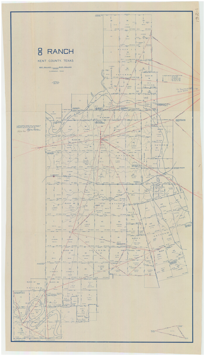
[8 Ranch, Kent County, Texas]
Print $20.00
- Digital $50.00
[8 Ranch, Kent County, Texas]
1946
Size: 21.4 x 37.4 inches
91032
Working Sketch of Surveys in Kent & Scurry Counties Located South of Clairemont, Texas

Print $20.00
- Digital $50.00
Working Sketch of Surveys in Kent & Scurry Counties Located South of Clairemont, Texas
1947
Size: 41.2 x 43.4 inches
89861
Working Sketch of Surveys in Kent & Scurry Co's.

Print $40.00
- Digital $50.00
Working Sketch of Surveys in Kent & Scurry Co's.
1950
Size: 50.7 x 36.6 inches
89860
Working Sketch in Dickens and Kent Counties

Print $20.00
- Digital $50.00
Working Sketch in Dickens and Kent Counties
1904
Size: 24.2 x 30.5 inches
91035
Stonewall County Sketch File B1

Print $20.00
- Digital $50.00
Stonewall County Sketch File B1
1901
Size: 36.2 x 34.9 inches
10379
Stonewall County Sketch File 5

Print $40.00
- Digital $50.00
Stonewall County Sketch File 5
Size: 14.9 x 14.4 inches
37206
Stonewall County Sketch File 4

Print $20.00
- Digital $50.00
Stonewall County Sketch File 4
Size: 18.2 x 25.7 inches
12363
Sketch of Kent Co.

Print $20.00
- Digital $50.00
Sketch of Kent Co.
1884
Size: 15.1 x 16.5 inches
439
Sketch of Garza Co.

Print $3.00
- Digital $50.00
Sketch of Garza Co.
1884
Size: 12.3 x 10.2 inches
468
Sketch of Crosby Co.

Print $20.00
- Digital $50.00
Sketch of Crosby Co.
1884
Size: 14.8 x 12.5 inches
506
Scurry County Working Sketch 8

Print $40.00
- Digital $50.00
Scurry County Working Sketch 8
1980
Size: 34.5 x 49.5 inches
63837
Scurry County Rolled Sketch 5

Print $40.00
- Digital $50.00
Scurry County Rolled Sketch 5
Size: 48.4 x 41.1 inches
9913
Scurry County Rolled Sketch 4

Print $20.00
- Digital $50.00
Scurry County Rolled Sketch 4
Size: 35.7 x 26.0 inches
7765
Scurry County Rolled Sketch 3

Print $40.00
- Digital $50.00
Scurry County Rolled Sketch 3
Size: 50.2 x 46.7 inches
9912
Scurry County Rolled Sketch 2

Print $20.00
- Digital $50.00
Scurry County Rolled Sketch 2
Size: 44.0 x 44.9 inches
9911
[Sketch showing parts of H. & G. N. RR. Co. Blocks 7 and 8, K. Aycock Block 4, G. H. & H. RR. Co. Block 5 and various surveys west]
Print $20.00
- Digital $50.00
[Sketch showing parts of H. & G. N. RR. Co. Blocks 7 and 8, K. Aycock Block 4, G. H. & H. RR. Co. Block 5 and various surveys west]
1902
-
Size
25.5 x 17.3 inches
-
Map/Doc
90871
-
Creation Date
1902
[Sketch showing Northwest corner of Fisher County, Northeast corner of Scurry County and South part of Kent County]
Print $20.00
- Digital $50.00
[Sketch showing Northwest corner of Fisher County, Northeast corner of Scurry County and South part of Kent County]
1900
-
Size
17.7 x 15.0 inches
-
Map/Doc
90917
-
Creation Date
1900
[S51-58, 27, 30, 303-306, 221-224, 562, 564]
Print $20.00
- Digital $50.00
[S51-58, 27, 30, 303-306, 221-224, 562, 564]
-
Size
31.1 x 15.6 inches
-
Map/Doc
92185
[North Line of Kent County/South Line of Dickens County]
Print $20.00
- Digital $50.00
[North Line of Kent County/South Line of Dickens County]
1892
-
Size
8.4 x 38.1 inches
-
Map/Doc
90937
-
Creation Date
1892
[Map of Counties South of Panhandle from Parmer to Childress in North to Andrews to Eastland in the South]
Print $3.00
- Digital $50.00
[Map of Counties South of Panhandle from Parmer to Childress in North to Andrews to Eastland in the South]
-
Size
14.9 x 10.7 inches
-
Map/Doc
92098
[Map of Block 97, Borden and Scurry Co (Exhibit A); Map of Southeastern part of Young Territory; Map of part of of Borden, Fisher, Kent, Mitchell, Scurry and Garza Cos. Showing the north boundary line of the T&P 80 mile reservation]
Print $20.00
- Digital $50.00
[Map of Block 97, Borden and Scurry Co (Exhibit A); Map of Southeastern part of Young Territory; Map of part of of Borden, Fisher, Kent, Mitchell, Scurry and Garza Cos. Showing the north boundary line of the T&P 80 mile reservation]
1873
-
Size
33.4 x 29.6 inches
-
Map/Doc
65692
-
Creation Date
1873
[Map of Block 97, Borden and Scurry Co (Exhibit A); Map of Southeastern part of Young Territory; Map of part of of Borden, Fisher, Kent, Mitchell, Scurry and Garza Cos. Showing the north boundary line of the T&P 80 mile reservation]
Print $20.00
- Digital $50.00
[Map of Block 97, Borden and Scurry Co (Exhibit A); Map of Southeastern part of Young Territory; Map of part of of Borden, Fisher, Kent, Mitchell, Scurry and Garza Cos. Showing the north boundary line of the T&P 80 mile reservation]
1901
-
Size
31.2 x 23.3 inches
-
Map/Doc
65693
-
Creation Date
1901
[Kent County Block 4, Sections 33 and 46, Block 97, Sections 771 and 772]
Print $2.00
- Digital $50.00
[Kent County Block 4, Sections 33 and 46, Block 97, Sections 771 and 772]
1951
-
Size
8.7 x 15.6 inches
-
Map/Doc
92192
-
Creation Date
1951
[H. & G.N. RR. Co. Block 4 and vicinity]
Print $20.00
- Digital $50.00
[H. & G.N. RR. Co. Block 4 and vicinity]
-
Size
40.8 x 37.4 inches
-
Map/Doc
92160
[H. & G. N. RR. Company, Block 7]
Print $20.00
- Digital $50.00
[H. & G. N. RR. Company, Block 7]
-
Size
14.7 x 21.4 inches
-
Map/Doc
91018
[H. & G. N. RR. Co. Block 1]
Print $20.00
- Digital $50.00
[H. & G. N. RR. Co. Block 1]
-
Size
17.1 x 28.0 inches
-
Map/Doc
90890
[H. & G. N. Block 1 resurvey]
Print $20.00
- Digital $50.00
[H. & G. N. Block 1 resurvey]
1902
-
Size
14.7 x 17.2 inches
-
Map/Doc
90951
-
Creation Date
1902
[County Line between Dickens and Kent Counties]
Print $20.00
- Digital $50.00
[County Line between Dickens and Kent Counties]
1891
-
Size
42.4 x 7.4 inches
-
Map/Doc
90938
-
Creation Date
1891
[8 Ranch, Kent County, Texas]
Print $20.00
- Digital $50.00
[8 Ranch, Kent County, Texas]
1946
-
Size
21.4 x 37.4 inches
-
Map/Doc
91032
-
Creation Date
1946
Young Territory

Print $20.00
- Digital $50.00
Young Territory
1873
-
Size
29.2 x 29.9 inches
-
Map/Doc
1976
-
Creation Date
1873
Working Sketch of Surveys in Kent & Scurry Counties Located South of Clairemont, Texas
Print $20.00
- Digital $50.00
Working Sketch of Surveys in Kent & Scurry Counties Located South of Clairemont, Texas
1947
-
Size
41.2 x 43.4 inches
-
Map/Doc
89861
-
Creation Date
1947
Working Sketch of Surveys in Kent & Scurry Co's.
Print $40.00
- Digital $50.00
Working Sketch of Surveys in Kent & Scurry Co's.
1950
-
Size
50.7 x 36.6 inches
-
Map/Doc
89860
-
Creation Date
1950
Working Sketch in Dickens and Kent Counties
Print $20.00
- Digital $50.00
Working Sketch in Dickens and Kent Counties
1904
-
Size
24.2 x 30.5 inches
-
Map/Doc
91035
-
Creation Date
1904
Stonewall County Sketch File B1
Print $20.00
- Digital $50.00
Stonewall County Sketch File B1
1901
-
Size
36.2 x 34.9 inches
-
Map/Doc
10379
-
Creation Date
1901
Stonewall County Sketch File 5
Print $40.00
- Digital $50.00
Stonewall County Sketch File 5
-
Size
14.9 x 14.4 inches
-
Map/Doc
37206
Stonewall County Sketch File 4
Print $20.00
- Digital $50.00
Stonewall County Sketch File 4
-
Size
18.2 x 25.7 inches
-
Map/Doc
12363
Sketch of Kent Co.
Print $20.00
- Digital $50.00
Sketch of Kent Co.
1884
-
Size
15.1 x 16.5 inches
-
Map/Doc
439
-
Creation Date
1884
Sketch of Garza Co.
Print $3.00
- Digital $50.00
Sketch of Garza Co.
1884
-
Size
12.3 x 10.2 inches
-
Map/Doc
468
-
Creation Date
1884
Sketch of Crosby Co.
Print $20.00
- Digital $50.00
Sketch of Crosby Co.
1884
-
Size
14.8 x 12.5 inches
-
Map/Doc
506
-
Creation Date
1884
Scurry County Working Sketch 8
Print $40.00
- Digital $50.00
Scurry County Working Sketch 8
1980
-
Size
34.5 x 49.5 inches
-
Map/Doc
63837
-
Creation Date
1980
Scurry County Rolled Sketch 5
Print $40.00
- Digital $50.00
Scurry County Rolled Sketch 5
-
Size
48.4 x 41.1 inches
-
Map/Doc
9913
Scurry County Rolled Sketch 4
Print $20.00
- Digital $50.00
Scurry County Rolled Sketch 4
-
Size
35.7 x 26.0 inches
-
Map/Doc
7765
Scurry County Rolled Sketch 3
Print $40.00
- Digital $50.00
Scurry County Rolled Sketch 3
-
Size
50.2 x 46.7 inches
-
Map/Doc
9912
Scurry County Rolled Sketch 2
Print $20.00
- Digital $50.00
Scurry County Rolled Sketch 2
-
Size
44.0 x 44.9 inches
-
Map/Doc
9911