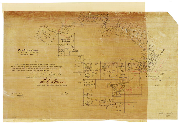
[Sketch of Surveys in] Tom Green County, [Texas]
Print $20.00
- Digital $50.00
[Sketch of Surveys in] Tom Green County, [Texas]
1882
Size: 14.1 x 20.3 inches
471
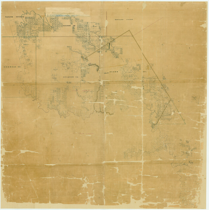
[Map of a portion of Bexar and Travis Districts]
Print $20.00
- Digital $50.00
[Map of a portion of Bexar and Travis Districts]
Size: 47.5 x 47.2 inches
16943
Working Sketch in SW cor. of Coleman Co. showing the excess in the surveys fronting on the river and the relative position of surveys north of them according to latest data on file in the Genl. Land Office

Print $20.00
- Digital $50.00
Working Sketch in SW cor. of Coleman Co. showing the excess in the surveys fronting on the river and the relative position of surveys north of them according to latest data on file in the Genl. Land Office
1892
Size: 18.8 x 14.1 inches
441
Water-Shed of the Colorado River

Print $40.00
- Digital $50.00
Water-Shed of the Colorado River
1925
Size: 37.1 x 79.8 inches
65261
Tom Green County Sketch File 75

Print $20.00
- Digital $50.00
Tom Green County Sketch File 75
1950
Size: 18.1 x 22.5 inches
12449
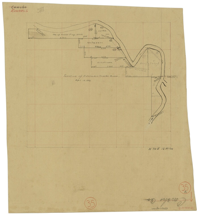
Tom Green County Sketch File 35

Print $6.00
- Digital $50.00
Tom Green County Sketch File 35
Size: 10.2 x 15.9 inches
38192
Tom Green County Sketch File 16

Print $16.00
- Digital $50.00
Tom Green County Sketch File 16
Size: 8.5 x 7.8 inches
38174
Taylor County Sketch File A

Print $2.00
- Digital $50.00
Taylor County Sketch File A
Size: 8.8 x 11.3 inches
37773
Taylor County Sketch File 4

Print $2.00
- Digital $50.00
Taylor County Sketch File 4
Size: 7.2 x 9.8 inches
37780
Taylor County Sketch File 12

Print $4.00
- Digital $50.00
Taylor County Sketch File 12
Size: 8.6 x 12.8 inches
37796
Survey Map of Runnels County

Print $20.00
- Digital $50.00
Survey Map of Runnels County
Size: 33.6 x 40.3 inches
92918
Runnels County Working Sketch Graphic Index

Print $20.00
- Digital $50.00
Runnels County Working Sketch Graphic Index
1948
Size: 46.8 x 36.9 inches
76687
Runnels County Working Sketch 9

Print $40.00
- Digital $50.00
Runnels County Working Sketch 9
1948
Size: 48.9 x 27.9 inches
63605
Runnels County Working Sketch 9

Print $40.00
- Digital $50.00
Runnels County Working Sketch 9
1948
Size: 48.8 x 30.1 inches
69712
Runnels County Working Sketch 8

Print $20.00
- Digital $50.00
Runnels County Working Sketch 8
1948
Size: 38.4 x 37.1 inches
63604
Runnels County Working Sketch 7

Print $20.00
- Digital $50.00
Runnels County Working Sketch 7
1929
Size: 29.5 x 14.9 inches
63603
Runnels County Working Sketch 6

Print $20.00
- Digital $50.00
Runnels County Working Sketch 6
1907
Size: 19.5 x 31.0 inches
63602
Runnels County Working Sketch 5

Print $20.00
- Digital $50.00
Runnels County Working Sketch 5
1907
Size: 17.2 x 16.1 inches
63601
Runnels County Working Sketch 4

Print $20.00
- Digital $50.00
Runnels County Working Sketch 4
1906
Size: 15.1 x 19.3 inches
63600
Runnels County Working Sketch 36

Print $20.00
- Digital $50.00
Runnels County Working Sketch 36
1984
Size: 31.9 x 39.2 inches
63635
Runnels County Working Sketch 35b

Print $20.00
- Digital $50.00
Runnels County Working Sketch 35b
1981
Size: 36.0 x 38.6 inches
63634
Runnels County Working Sketch 35a
Print $20.00
- Digital $50.00
Runnels County Working Sketch 35a
Size: 14.9 x 14.2 inches
63633
Runnels County Working Sketch 34

Print $20.00
- Digital $50.00
Runnels County Working Sketch 34
1974
Size: 14.0 x 14.9 inches
63632
Runnels County Working Sketch 33

Print $20.00
- Digital $50.00
Runnels County Working Sketch 33
Size: 26.5 x 22.6 inches
63631
Runnels County Working Sketch 32

Print $20.00
- Digital $50.00
Runnels County Working Sketch 32
1959
Size: 27.7 x 24.0 inches
63630
Runnels County Working Sketch 31

Print $20.00
- Digital $50.00
Runnels County Working Sketch 31
1959
Size: 28.3 x 31.3 inches
63629
Runnels County Working Sketch 30c

Print $20.00
- Digital $50.00
Runnels County Working Sketch 30c
1959
Size: 30.5 x 32.1 inches
63628
Runnels County Working Sketch 30b

Print $20.00
- Digital $50.00
Runnels County Working Sketch 30b
Size: 23.2 x 25.3 inches
63627
Runnels County Working Sketch 30a

Print $20.00
- Digital $50.00
Runnels County Working Sketch 30a
1959
Size: 23.3 x 25.4 inches
63626
Runnels County Working Sketch 3

Print $20.00
- Digital $50.00
Runnels County Working Sketch 3
1888
Size: 22.1 x 20.3 inches
63599
[Sketch of Surveys in] Tom Green County, [Texas]
Print $20.00
- Digital $50.00
[Sketch of Surveys in] Tom Green County, [Texas]
1882
-
Size
14.1 x 20.3 inches
-
Map/Doc
471
-
Creation Date
1882
[Map of a portion of Bexar and Travis Districts]
Print $20.00
- Digital $50.00
[Map of a portion of Bexar and Travis Districts]
-
Size
47.5 x 47.2 inches
-
Map/Doc
16943
Working Sketch in SW cor. of Coleman Co. showing the excess in the surveys fronting on the river and the relative position of surveys north of them according to latest data on file in the Genl. Land Office
Print $20.00
- Digital $50.00
Working Sketch in SW cor. of Coleman Co. showing the excess in the surveys fronting on the river and the relative position of surveys north of them according to latest data on file in the Genl. Land Office
1892
-
Size
18.8 x 14.1 inches
-
Map/Doc
441
-
Creation Date
1892
Water-Shed of the Colorado River
Print $40.00
- Digital $50.00
Water-Shed of the Colorado River
1925
-
Size
37.1 x 79.8 inches
-
Map/Doc
65261
-
Creation Date
1925
Tom Green County Sketch File 75
Print $20.00
- Digital $50.00
Tom Green County Sketch File 75
1950
-
Size
18.1 x 22.5 inches
-
Map/Doc
12449
-
Creation Date
1950
Tom Green County Sketch File 35
Print $6.00
- Digital $50.00
Tom Green County Sketch File 35
-
Size
10.2 x 15.9 inches
-
Map/Doc
38192
Tom Green County Sketch File 16
Print $16.00
- Digital $50.00
Tom Green County Sketch File 16
-
Size
8.5 x 7.8 inches
-
Map/Doc
38174
Taylor County Sketch File A
Print $2.00
- Digital $50.00
Taylor County Sketch File A
-
Size
8.8 x 11.3 inches
-
Map/Doc
37773
Taylor County Sketch File 4
Print $2.00
- Digital $50.00
Taylor County Sketch File 4
-
Size
7.2 x 9.8 inches
-
Map/Doc
37780
Taylor County Sketch File 12
Print $4.00
- Digital $50.00
Taylor County Sketch File 12
-
Size
8.6 x 12.8 inches
-
Map/Doc
37796
Survey Map of Runnels County
Print $20.00
- Digital $50.00
Survey Map of Runnels County
-
Size
33.6 x 40.3 inches
-
Map/Doc
92918
Runnels County Working Sketch Graphic Index
Print $20.00
- Digital $50.00
Runnels County Working Sketch Graphic Index
1948
-
Size
46.8 x 36.9 inches
-
Map/Doc
76687
-
Creation Date
1948
Runnels County Working Sketch 9
Print $40.00
- Digital $50.00
Runnels County Working Sketch 9
1948
-
Size
48.9 x 27.9 inches
-
Map/Doc
63605
-
Creation Date
1948
Runnels County Working Sketch 9
Print $40.00
- Digital $50.00
Runnels County Working Sketch 9
1948
-
Size
48.8 x 30.1 inches
-
Map/Doc
69712
-
Creation Date
1948
Runnels County Working Sketch 8
Print $20.00
- Digital $50.00
Runnels County Working Sketch 8
1948
-
Size
38.4 x 37.1 inches
-
Map/Doc
63604
-
Creation Date
1948
Runnels County Working Sketch 7
Print $20.00
- Digital $50.00
Runnels County Working Sketch 7
1929
-
Size
29.5 x 14.9 inches
-
Map/Doc
63603
-
Creation Date
1929
Runnels County Working Sketch 6
Print $20.00
- Digital $50.00
Runnels County Working Sketch 6
1907
-
Size
19.5 x 31.0 inches
-
Map/Doc
63602
-
Creation Date
1907
Runnels County Working Sketch 5
Print $20.00
- Digital $50.00
Runnels County Working Sketch 5
1907
-
Size
17.2 x 16.1 inches
-
Map/Doc
63601
-
Creation Date
1907
Runnels County Working Sketch 4
Print $20.00
- Digital $50.00
Runnels County Working Sketch 4
1906
-
Size
15.1 x 19.3 inches
-
Map/Doc
63600
-
Creation Date
1906
Runnels County Working Sketch 36
Print $20.00
- Digital $50.00
Runnels County Working Sketch 36
1984
-
Size
31.9 x 39.2 inches
-
Map/Doc
63635
-
Creation Date
1984
Runnels County Working Sketch 35b
Print $20.00
- Digital $50.00
Runnels County Working Sketch 35b
1981
-
Size
36.0 x 38.6 inches
-
Map/Doc
63634
-
Creation Date
1981
Runnels County Working Sketch 35a
Print $20.00
- Digital $50.00
Runnels County Working Sketch 35a
-
Size
14.9 x 14.2 inches
-
Map/Doc
63633
Runnels County Working Sketch 34
Print $20.00
- Digital $50.00
Runnels County Working Sketch 34
1974
-
Size
14.0 x 14.9 inches
-
Map/Doc
63632
-
Creation Date
1974
Runnels County Working Sketch 33
Print $20.00
- Digital $50.00
Runnels County Working Sketch 33
-
Size
26.5 x 22.6 inches
-
Map/Doc
63631
Runnels County Working Sketch 32
Print $20.00
- Digital $50.00
Runnels County Working Sketch 32
1959
-
Size
27.7 x 24.0 inches
-
Map/Doc
63630
-
Creation Date
1959
Runnels County Working Sketch 31
Print $20.00
- Digital $50.00
Runnels County Working Sketch 31
1959
-
Size
28.3 x 31.3 inches
-
Map/Doc
63629
-
Creation Date
1959
Runnels County Working Sketch 30c
Print $20.00
- Digital $50.00
Runnels County Working Sketch 30c
1959
-
Size
30.5 x 32.1 inches
-
Map/Doc
63628
-
Creation Date
1959
Runnels County Working Sketch 30b
Print $20.00
- Digital $50.00
Runnels County Working Sketch 30b
-
Size
23.2 x 25.3 inches
-
Map/Doc
63627
Runnels County Working Sketch 30a
Print $20.00
- Digital $50.00
Runnels County Working Sketch 30a
1959
-
Size
23.3 x 25.4 inches
-
Map/Doc
63626
-
Creation Date
1959
Runnels County Working Sketch 3
Print $20.00
- Digital $50.00
Runnels County Working Sketch 3
1888
-
Size
22.1 x 20.3 inches
-
Map/Doc
63599
-
Creation Date
1888