Fisher County Sketch File 1

Print $20.00
- Digital $50.00
Fisher County Sketch File 1
Size: 43.5 x 18.3 inches
10448
Nolan County Sketch File 2

Print $40.00
- Digital $50.00
Nolan County Sketch File 2
Size: 49.5 x 41.6 inches
10556
Fisher County Sketch File 10

Print $20.00
- Digital $50.00
Fisher County Sketch File 10
Size: 9.7 x 37.0 inches
11477
Scurry County Sketch File 3

Print $20.00
- Digital $50.00
Scurry County Sketch File 3
Size: 22.0 x 24.2 inches
12312
Scurry County Sketch File 1

Print $6.00
- Digital $50.00
Scurry County Sketch File 1
Size: 14.5 x 9.1 inches
36560
Map of Alabama and Texas Cattle Co's Pasture

Print $20.00
- Digital $50.00
Map of Alabama and Texas Cattle Co's Pasture
Size: 17.6 x 18.1 inches
5064
Scurry County Boundary File 1

Print $74.00
- Digital $50.00
Scurry County Boundary File 1
Size: 9.2 x 3.8 inches
58597
Scurry County Working Sketch 1

Print $20.00
- Digital $50.00
Scurry County Working Sketch 1
Size: 17.9 x 22.7 inches
63830
Maps of Block 97, Borden & Scurry Counties

Print $40.00
- Digital $50.00
Maps of Block 97, Borden & Scurry Counties
Size: 58.2 x 42.2 inches
65691
Scurry County Rolled Sketch 2A

Print $20.00
- Digital $50.00
Scurry County Rolled Sketch 2A
Size: 25.6 x 24.2 inches
7764
Scurry County Rolled Sketch 4

Print $20.00
- Digital $50.00
Scurry County Rolled Sketch 4
Size: 35.7 x 26.0 inches
7765
Scurry County Rolled Sketch 11

Print $20.00
- Digital $50.00
Scurry County Rolled Sketch 11
Size: 20.2 x 16.8 inches
7771
Map of Scurry County

Print $20.00
- Digital $50.00
Map of Scurry County
Size: 17.8 x 22.7 inches
92921
Site Development Study for the D. M. Cogdell Memorial Hospital Snyder, Texas

Print $20.00
- Digital $50.00
Site Development Study for the D. M. Cogdell Memorial Hospital Snyder, Texas
Size: 24.1 x 26.8 inches
92922
Scurry County Rolled Sketch 1

Print $40.00
- Digital $50.00
Scurry County Rolled Sketch 1
Size: 70.5 x 44.9 inches
9910
Scurry County Rolled Sketch 2

Print $20.00
- Digital $50.00
Scurry County Rolled Sketch 2
Size: 44.0 x 44.9 inches
9911
Scurry County Rolled Sketch 3

Print $40.00
- Digital $50.00
Scurry County Rolled Sketch 3
Size: 50.2 x 46.7 inches
9912
Scurry County Rolled Sketch 5

Print $40.00
- Digital $50.00
Scurry County Rolled Sketch 5
Size: 48.4 x 41.1 inches
9913
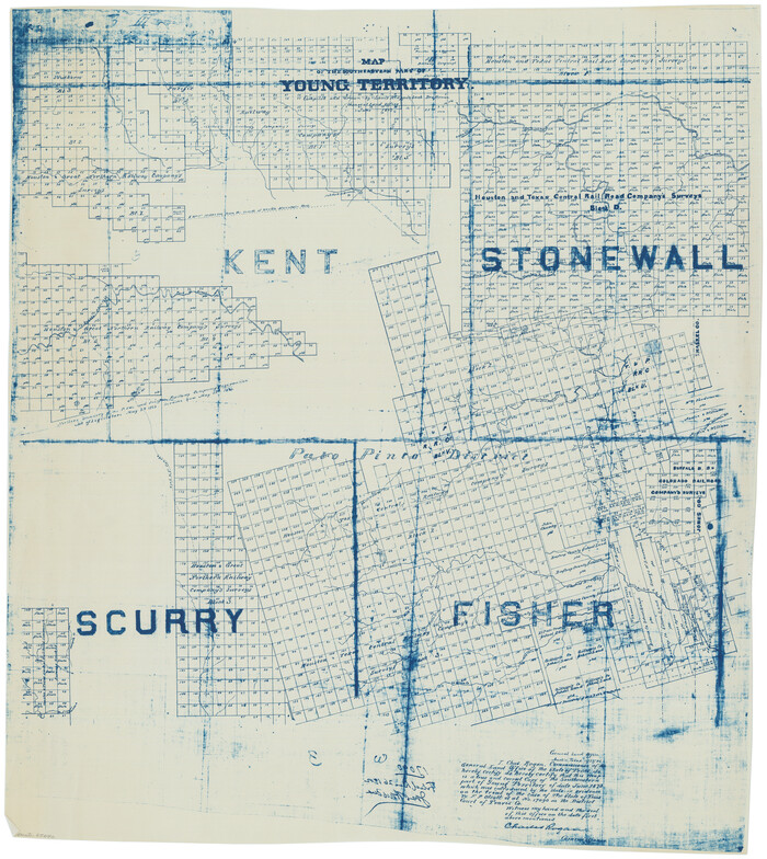
[Map of Block 97, Borden and Scurry Co (Exhibit A); Map of Southeastern part of Young Territory; Map of part of of Borden, Fisher, Kent, Mitchell, Scurry and Garza Cos. Showing the north boundary line of the T&P 80 mile reservation]
Print $20.00
- Digital $50.00
[Map of Block 97, Borden and Scurry Co (Exhibit A); Map of Southeastern part of Young Territory; Map of part of of Borden, Fisher, Kent, Mitchell, Scurry and Garza Cos. Showing the north boundary line of the T&P 80 mile reservation]
1873
Size: 33.4 x 29.6 inches
65692
Map of Southeastern Part of Young Territory

Print $40.00
- Digital $50.00
Map of Southeastern Part of Young Territory
1874
Size: 54.7 x 30.1 inches
1989
Nolan County, Texas

Print $20.00
- Digital $50.00
Nolan County, Texas
1880
Size: 29.5 x 22.7 inches
588
Scurry County Sketch File 4

Print $26.00
- Digital $50.00
Scurry County Sketch File 4
1881
Size: 13.1 x 8.5 inches
36565
Portion of Scurry County

Print $20.00
- Digital $50.00
Portion of Scurry County
1882
Size: 35.1 x 25.3 inches
92923
[North 3/4 of County]
Print $20.00
- Digital $50.00
[North 3/4 of County]
1887
Size: 26.0 x 15.4 inches
90840
Fisher County Sketch File 5

Print $20.00
- Digital $50.00
Fisher County Sketch File 5
1887
Size: 35.3 x 47.6 inches
10449
Block 2 T. & N. Ry. Co., Block 97 H. T. C. Ry. Co.

Print $40.00
- Digital $50.00
Block 2 T. & N. Ry. Co., Block 97 H. T. C. Ry. Co.
1888
Size: 41.5 x 48.1 inches
89874
Scurry County Sketch File 2

Print $4.00
- Digital $50.00
Scurry County Sketch File 2
1888
Size: 13.2 x 7.4 inches
36563
Fisher County Sketch File 1
Print $20.00
- Digital $50.00
Fisher County Sketch File 1
-
Size
43.5 x 18.3 inches
-
Map/Doc
10448
Nolan County Sketch File 2
Print $40.00
- Digital $50.00
Nolan County Sketch File 2
-
Size
49.5 x 41.6 inches
-
Map/Doc
10556
Fisher County Sketch File 10
Print $20.00
- Digital $50.00
Fisher County Sketch File 10
-
Size
9.7 x 37.0 inches
-
Map/Doc
11477
Scurry County Sketch File 3
Print $20.00
- Digital $50.00
Scurry County Sketch File 3
-
Size
22.0 x 24.2 inches
-
Map/Doc
12312
Scurry County Sketch File 1
Print $6.00
- Digital $50.00
Scurry County Sketch File 1
-
Size
14.5 x 9.1 inches
-
Map/Doc
36560
Map of Alabama and Texas Cattle Co's Pasture
Print $20.00
- Digital $50.00
Map of Alabama and Texas Cattle Co's Pasture
-
Size
17.6 x 18.1 inches
-
Map/Doc
5064
Scurry County Boundary File 1
Print $74.00
- Digital $50.00
Scurry County Boundary File 1
-
Size
9.2 x 3.8 inches
-
Map/Doc
58597
Scurry County Working Sketch 1
Print $20.00
- Digital $50.00
Scurry County Working Sketch 1
-
Size
17.9 x 22.7 inches
-
Map/Doc
63830
Maps of Block 97, Borden & Scurry Counties
Print $40.00
- Digital $50.00
Maps of Block 97, Borden & Scurry Counties
-
Size
58.2 x 42.2 inches
-
Map/Doc
65691
Scurry County Rolled Sketch 2A
Print $20.00
- Digital $50.00
Scurry County Rolled Sketch 2A
-
Size
25.6 x 24.2 inches
-
Map/Doc
7764
Scurry County Rolled Sketch 4
Print $20.00
- Digital $50.00
Scurry County Rolled Sketch 4
-
Size
35.7 x 26.0 inches
-
Map/Doc
7765
Scurry County Rolled Sketch 11
Print $20.00
- Digital $50.00
Scurry County Rolled Sketch 11
-
Size
20.2 x 16.8 inches
-
Map/Doc
7771
Map of Scurry County
Print $20.00
- Digital $50.00
Map of Scurry County
-
Size
17.8 x 22.7 inches
-
Map/Doc
92921
Site Development Study for the D. M. Cogdell Memorial Hospital Snyder, Texas
Print $20.00
- Digital $50.00
Site Development Study for the D. M. Cogdell Memorial Hospital Snyder, Texas
-
Size
24.1 x 26.8 inches
-
Map/Doc
92922
Scurry County Rolled Sketch 1
Print $40.00
- Digital $50.00
Scurry County Rolled Sketch 1
-
Size
70.5 x 44.9 inches
-
Map/Doc
9910
Scurry County Rolled Sketch 2
Print $20.00
- Digital $50.00
Scurry County Rolled Sketch 2
-
Size
44.0 x 44.9 inches
-
Map/Doc
9911
Scurry County Rolled Sketch 3
Print $40.00
- Digital $50.00
Scurry County Rolled Sketch 3
-
Size
50.2 x 46.7 inches
-
Map/Doc
9912
Scurry County Rolled Sketch 5
Print $40.00
- Digital $50.00
Scurry County Rolled Sketch 5
-
Size
48.4 x 41.1 inches
-
Map/Doc
9913
Young Territory

Print $20.00
- Digital $50.00
Young Territory
1873
-
Size
29.2 x 29.9 inches
-
Map/Doc
1976
-
Creation Date
1873
[Map of Block 97, Borden and Scurry Co (Exhibit A); Map of Southeastern part of Young Territory; Map of part of of Borden, Fisher, Kent, Mitchell, Scurry and Garza Cos. Showing the north boundary line of the T&P 80 mile reservation]
Print $20.00
- Digital $50.00
[Map of Block 97, Borden and Scurry Co (Exhibit A); Map of Southeastern part of Young Territory; Map of part of of Borden, Fisher, Kent, Mitchell, Scurry and Garza Cos. Showing the north boundary line of the T&P 80 mile reservation]
1873
-
Size
33.4 x 29.6 inches
-
Map/Doc
65692
-
Creation Date
1873
Map of Southeastern Part of Young Territory
Print $40.00
- Digital $50.00
Map of Southeastern Part of Young Territory
1874
-
Size
54.7 x 30.1 inches
-
Map/Doc
1989
-
Creation Date
1874
Nolan County, Texas
Print $20.00
- Digital $50.00
Nolan County, Texas
1880
-
Size
29.5 x 22.7 inches
-
Map/Doc
588
-
Creation Date
1880
Scurry County

Print $20.00
- Digital $50.00
Scurry County
1880
-
Size
22.8 x 20.4 inches
-
Map/Doc
4023
-
Creation Date
1880
Scurry County Sketch File 4
Print $26.00
- Digital $50.00
Scurry County Sketch File 4
1881
-
Size
13.1 x 8.5 inches
-
Map/Doc
36565
-
Creation Date
1881
Portion of Scurry County
Print $20.00
- Digital $50.00
Portion of Scurry County
1882
-
Size
35.1 x 25.3 inches
-
Map/Doc
92923
-
Creation Date
1882
Scurry County

Print $20.00
- Digital $50.00
Scurry County
1884
-
Size
21.4 x 19.0 inches
-
Map/Doc
4024
-
Creation Date
1884
[North 3/4 of County]
Print $20.00
- Digital $50.00
[North 3/4 of County]
1887
-
Size
26.0 x 15.4 inches
-
Map/Doc
90840
-
Creation Date
1887
Fisher County Sketch File 5
Print $20.00
- Digital $50.00
Fisher County Sketch File 5
1887
-
Size
35.3 x 47.6 inches
-
Map/Doc
10449
-
Creation Date
1887
Block 2 T. & N. Ry. Co., Block 97 H. T. C. Ry. Co.
Print $40.00
- Digital $50.00
Block 2 T. & N. Ry. Co., Block 97 H. T. C. Ry. Co.
1888
-
Size
41.5 x 48.1 inches
-
Map/Doc
89874
-
Creation Date
1888
Scurry County Sketch File 2
Print $4.00
- Digital $50.00
Scurry County Sketch File 2
1888
-
Size
13.2 x 7.4 inches
-
Map/Doc
36563
-
Creation Date
1888