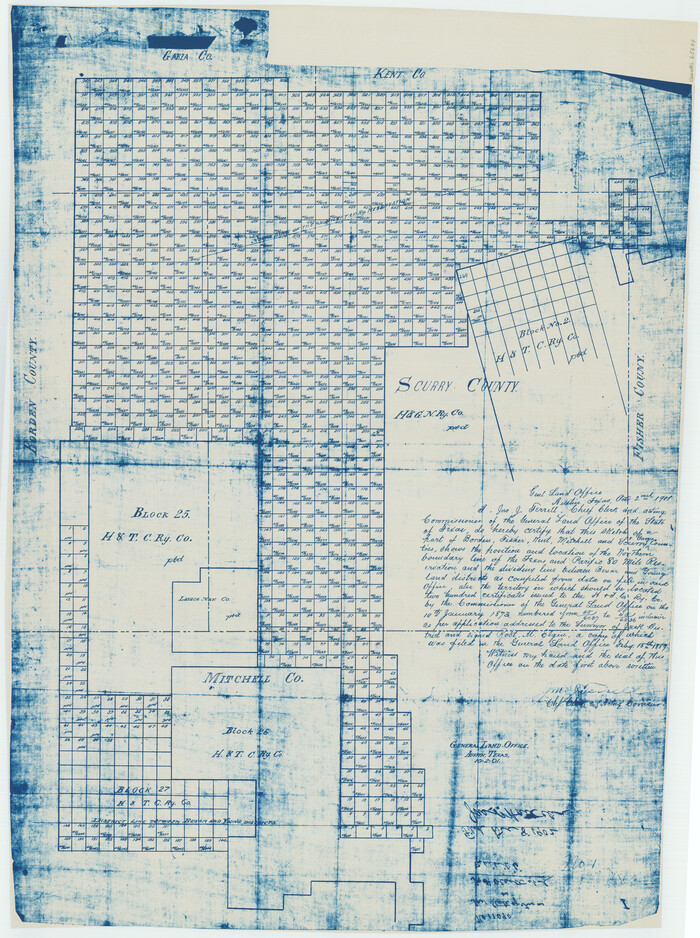
[Sketch showing Northwest corner of Fisher County, Northeast corner of Scurry County and South part of Kent County]
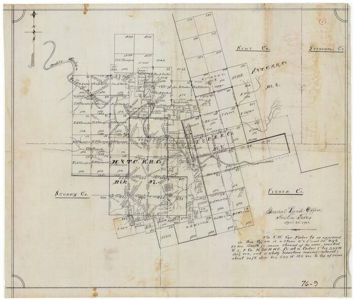
Print $20.00
- Digital $50.00
[Sketch showing Northwest corner of Fisher County, Northeast corner of Scurry County and South part of Kent County]
1900
Size: 17.7 x 15.0 inches
90917
[Plat No. 1, Connecting line from SW corner of Jones Co. to SE corner of Borden Co.]
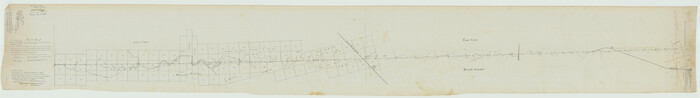
Print $40.00
- Digital $50.00
[Plat No. 1, Connecting line from SW corner of Jones Co. to SE corner of Borden Co.]
1908
Size: 18.1 x 128.8 inches
1698
[North 3/4 of County]
Print $20.00
- Digital $50.00
[North 3/4 of County]
1887
Size: 26.0 x 15.4 inches
90840
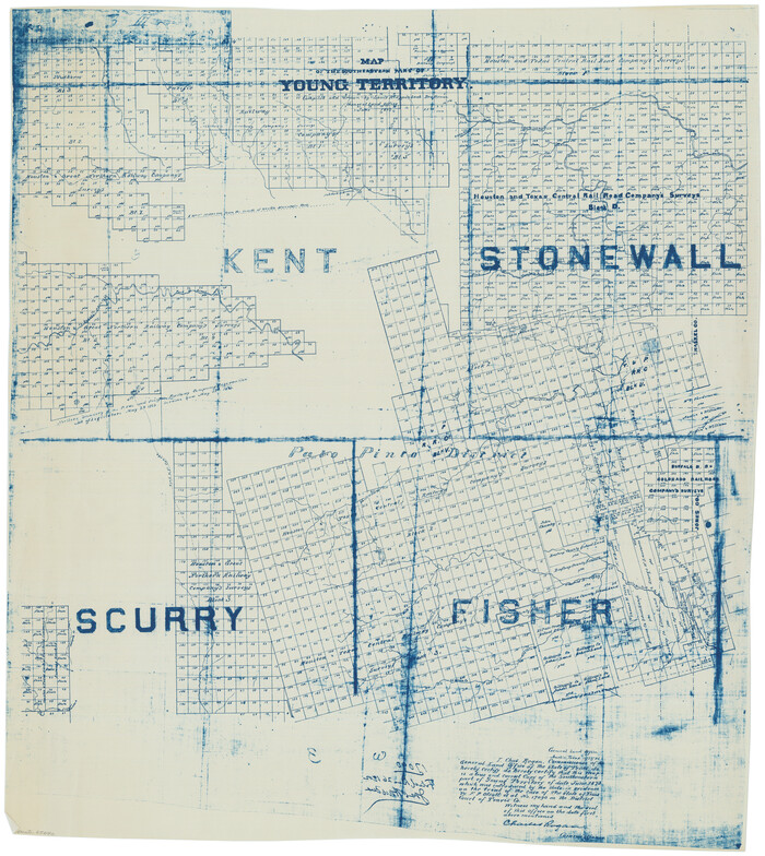
[Map of Block 97, Borden and Scurry Co (Exhibit A); Map of Southeastern part of Young Territory; Map of part of of Borden, Fisher, Kent, Mitchell, Scurry and Garza Cos. Showing the north boundary line of the T&P 80 mile reservation]
Print $20.00
- Digital $50.00
[Map of Block 97, Borden and Scurry Co (Exhibit A); Map of Southeastern part of Young Territory; Map of part of of Borden, Fisher, Kent, Mitchell, Scurry and Garza Cos. Showing the north boundary line of the T&P 80 mile reservation]
1873
Size: 33.4 x 29.6 inches
65692
[Map of Block 97, Borden and Scurry Co (Exhibit A); Map of Southeastern part of Young Territory; Map of part of of Borden, Fisher, Kent, Mitchell, Scurry and Garza Cos. Showing the north boundary line of the T&P 80 mile reservation]
Print $20.00
- Digital $50.00
[Map of Block 97, Borden and Scurry Co (Exhibit A); Map of Southeastern part of Young Territory; Map of part of of Borden, Fisher, Kent, Mitchell, Scurry and Garza Cos. Showing the north boundary line of the T&P 80 mile reservation]
1901
Size: 31.2 x 23.3 inches
65693
Working Sketch of Surveys in Kent & Scurry Counties Located South of Clairemont, Texas

Print $20.00
- Digital $50.00
Working Sketch of Surveys in Kent & Scurry Counties Located South of Clairemont, Texas
1947
Size: 41.2 x 43.4 inches
89861
Working Sketch of Surveys in Kent & Scurry Co's.

Print $40.00
- Digital $50.00
Working Sketch of Surveys in Kent & Scurry Co's.
1950
Size: 50.7 x 36.6 inches
89860
Water-Shed of the Colorado River

Print $40.00
- Digital $50.00
Water-Shed of the Colorado River
1925
Size: 37.1 x 79.8 inches
65261
Sketch showing county lines of Lynn, Garza, Borden, Scurry

Print $40.00
- Digital $50.00
Sketch showing county lines of Lynn, Garza, Borden, Scurry
1961
Size: 23.9 x 79.9 inches
1719
Site Development Study for the D. M. Cogdell Memorial Hospital Snyder, Texas

Print $20.00
- Digital $50.00
Site Development Study for the D. M. Cogdell Memorial Hospital Snyder, Texas
Size: 24.1 x 26.8 inches
92922
Scurry County Working Sketch Graphic Index

Print $20.00
- Digital $50.00
Scurry County Working Sketch Graphic Index
1921
Size: 39.9 x 37.0 inches
76695
Scurry County Working Sketch 9

Print $20.00
- Digital $50.00
Scurry County Working Sketch 9
1982
Size: 37.8 x 43.5 inches
63838
Scurry County Working Sketch 8

Print $40.00
- Digital $50.00
Scurry County Working Sketch 8
1980
Size: 34.5 x 49.5 inches
63837
Scurry County Working Sketch 7

Print $20.00
- Digital $50.00
Scurry County Working Sketch 7
1971
Size: 33.5 x 29.0 inches
63836
Scurry County Working Sketch 6

Print $20.00
- Digital $50.00
Scurry County Working Sketch 6
1950
Size: 38.7 x 37.3 inches
63835
Scurry County Working Sketch 5

Print $40.00
- Digital $50.00
Scurry County Working Sketch 5
1950
Size: 72.5 x 27.8 inches
63834
Scurry County Working Sketch 4
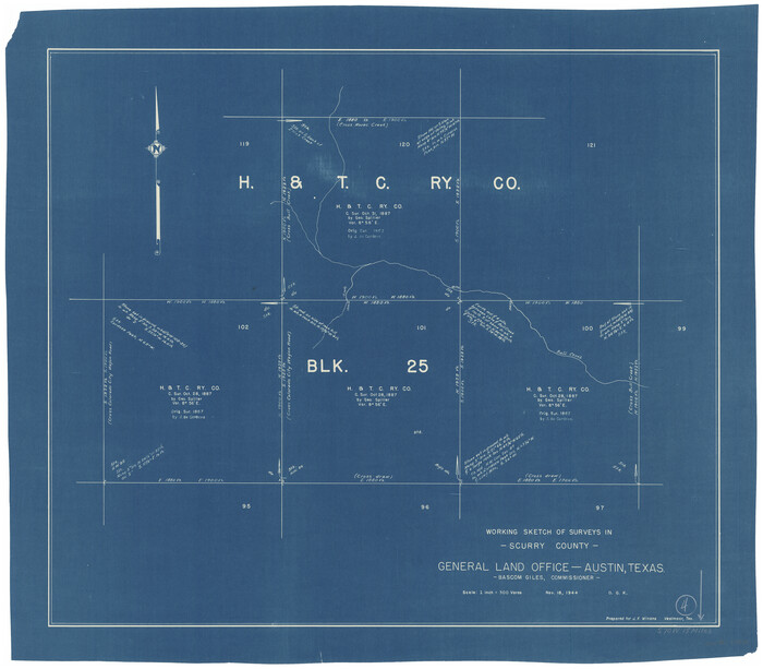
Print $20.00
- Digital $50.00
Scurry County Working Sketch 4
1944
Size: 23.1 x 26.5 inches
63833
Scurry County Working Sketch 3

Print $20.00
- Digital $50.00
Scurry County Working Sketch 3
1941
Size: 20.7 x 12.4 inches
63832
Scurry County Working Sketch 2

Print $3.00
- Digital $50.00
Scurry County Working Sketch 2
1934
Size: 16.2 x 10.2 inches
63831
Scurry County Working Sketch 11

Print $20.00
- Digital $50.00
Scurry County Working Sketch 11
1999
Size: 26.1 x 24.1 inches
63840
Scurry County Working Sketch 10

Print $20.00
- Digital $50.00
Scurry County Working Sketch 10
1990
Size: 25.7 x 28.7 inches
63839
Scurry County Working Sketch 1

Print $20.00
- Digital $50.00
Scurry County Working Sketch 1
Size: 17.9 x 22.7 inches
63830
Scurry County Sketch Mineral Application No. 42631

Print $20.00
- Digital $50.00
Scurry County Sketch Mineral Application No. 42631
1950
Size: 16.7 x 23.9 inches
92966
Scurry County Sketch Mineral Application No. 42315

Print $20.00
- Digital $50.00
Scurry County Sketch Mineral Application No. 42315
1950
Size: 24.2 x 16.4 inches
92926
Scurry County Sketch Mineral Application No. 42315

Print $20.00
- Digital $50.00
Scurry County Sketch Mineral Application No. 42315
1950
Size: 24.0 x 16.5 inches
92965
Scurry County Sketch File 6

Print $14.00
- Digital $50.00
Scurry County Sketch File 6
2002
Size: 11.2 x 8.7 inches
76370
Scurry County Sketch File 5

Print $4.00
- Digital $50.00
Scurry County Sketch File 5
1990
Size: 14.4 x 8.9 inches
36568
Scurry County Sketch File 4

Print $26.00
- Digital $50.00
Scurry County Sketch File 4
1881
Size: 13.1 x 8.5 inches
36565
[Sketch showing Northwest corner of Fisher County, Northeast corner of Scurry County and South part of Kent County]
Print $20.00
- Digital $50.00
[Sketch showing Northwest corner of Fisher County, Northeast corner of Scurry County and South part of Kent County]
1900
-
Size
17.7 x 15.0 inches
-
Map/Doc
90917
-
Creation Date
1900
[Scurry County]
![63030, [Scurry County], General Map Collection](https://historictexasmaps.com/wmedia_w700/maps/63030.tif.jpg)
Print $20.00
- Digital $50.00
[Scurry County]
1901
-
Size
34.3 x 42.5 inches
-
Map/Doc
63030
-
Creation Date
1901
[Plat No. 1, Connecting line from SW corner of Jones Co. to SE corner of Borden Co.]
Print $40.00
- Digital $50.00
[Plat No. 1, Connecting line from SW corner of Jones Co. to SE corner of Borden Co.]
1908
-
Size
18.1 x 128.8 inches
-
Map/Doc
1698
-
Creation Date
1908
[North 3/4 of County]
Print $20.00
- Digital $50.00
[North 3/4 of County]
1887
-
Size
26.0 x 15.4 inches
-
Map/Doc
90840
-
Creation Date
1887
[Map of Block 97, Borden and Scurry Co (Exhibit A); Map of Southeastern part of Young Territory; Map of part of of Borden, Fisher, Kent, Mitchell, Scurry and Garza Cos. Showing the north boundary line of the T&P 80 mile reservation]
Print $20.00
- Digital $50.00
[Map of Block 97, Borden and Scurry Co (Exhibit A); Map of Southeastern part of Young Territory; Map of part of of Borden, Fisher, Kent, Mitchell, Scurry and Garza Cos. Showing the north boundary line of the T&P 80 mile reservation]
1873
-
Size
33.4 x 29.6 inches
-
Map/Doc
65692
-
Creation Date
1873
[Map of Block 97, Borden and Scurry Co (Exhibit A); Map of Southeastern part of Young Territory; Map of part of of Borden, Fisher, Kent, Mitchell, Scurry and Garza Cos. Showing the north boundary line of the T&P 80 mile reservation]
Print $20.00
- Digital $50.00
[Map of Block 97, Borden and Scurry Co (Exhibit A); Map of Southeastern part of Young Territory; Map of part of of Borden, Fisher, Kent, Mitchell, Scurry and Garza Cos. Showing the north boundary line of the T&P 80 mile reservation]
1901
-
Size
31.2 x 23.3 inches
-
Map/Doc
65693
-
Creation Date
1901
Young Territory

Print $20.00
- Digital $50.00
Young Territory
1873
-
Size
29.2 x 29.9 inches
-
Map/Doc
1976
-
Creation Date
1873
Working Sketch of Surveys in Kent & Scurry Counties Located South of Clairemont, Texas
Print $20.00
- Digital $50.00
Working Sketch of Surveys in Kent & Scurry Counties Located South of Clairemont, Texas
1947
-
Size
41.2 x 43.4 inches
-
Map/Doc
89861
-
Creation Date
1947
Working Sketch of Surveys in Kent & Scurry Co's.
Print $40.00
- Digital $50.00
Working Sketch of Surveys in Kent & Scurry Co's.
1950
-
Size
50.7 x 36.6 inches
-
Map/Doc
89860
-
Creation Date
1950
Water-Shed of the Colorado River
Print $40.00
- Digital $50.00
Water-Shed of the Colorado River
1925
-
Size
37.1 x 79.8 inches
-
Map/Doc
65261
-
Creation Date
1925
Sketch showing county lines of Lynn, Garza, Borden, Scurry
Print $40.00
- Digital $50.00
Sketch showing county lines of Lynn, Garza, Borden, Scurry
1961
-
Size
23.9 x 79.9 inches
-
Map/Doc
1719
-
Creation Date
1961
Site Development Study for the D. M. Cogdell Memorial Hospital Snyder, Texas
Print $20.00
- Digital $50.00
Site Development Study for the D. M. Cogdell Memorial Hospital Snyder, Texas
-
Size
24.1 x 26.8 inches
-
Map/Doc
92922
Scurry County Working Sketch Graphic Index
Print $20.00
- Digital $50.00
Scurry County Working Sketch Graphic Index
1921
-
Size
39.9 x 37.0 inches
-
Map/Doc
76695
-
Creation Date
1921
Scurry County Working Sketch 9
Print $20.00
- Digital $50.00
Scurry County Working Sketch 9
1982
-
Size
37.8 x 43.5 inches
-
Map/Doc
63838
-
Creation Date
1982
Scurry County Working Sketch 8
Print $40.00
- Digital $50.00
Scurry County Working Sketch 8
1980
-
Size
34.5 x 49.5 inches
-
Map/Doc
63837
-
Creation Date
1980
Scurry County Working Sketch 7
Print $20.00
- Digital $50.00
Scurry County Working Sketch 7
1971
-
Size
33.5 x 29.0 inches
-
Map/Doc
63836
-
Creation Date
1971
Scurry County Working Sketch 6
Print $20.00
- Digital $50.00
Scurry County Working Sketch 6
1950
-
Size
38.7 x 37.3 inches
-
Map/Doc
63835
-
Creation Date
1950
Scurry County Working Sketch 5
Print $40.00
- Digital $50.00
Scurry County Working Sketch 5
1950
-
Size
72.5 x 27.8 inches
-
Map/Doc
63834
-
Creation Date
1950
Scurry County Working Sketch 4
Print $20.00
- Digital $50.00
Scurry County Working Sketch 4
1944
-
Size
23.1 x 26.5 inches
-
Map/Doc
63833
-
Creation Date
1944
Scurry County Working Sketch 3
Print $20.00
- Digital $50.00
Scurry County Working Sketch 3
1941
-
Size
20.7 x 12.4 inches
-
Map/Doc
63832
-
Creation Date
1941
Scurry County Working Sketch 2
Print $3.00
- Digital $50.00
Scurry County Working Sketch 2
1934
-
Size
16.2 x 10.2 inches
-
Map/Doc
63831
-
Creation Date
1934
Scurry County Working Sketch 11
Print $20.00
- Digital $50.00
Scurry County Working Sketch 11
1999
-
Size
26.1 x 24.1 inches
-
Map/Doc
63840
-
Creation Date
1999
Scurry County Working Sketch 10
Print $20.00
- Digital $50.00
Scurry County Working Sketch 10
1990
-
Size
25.7 x 28.7 inches
-
Map/Doc
63839
-
Creation Date
1990
Scurry County Working Sketch 1
Print $20.00
- Digital $50.00
Scurry County Working Sketch 1
-
Size
17.9 x 22.7 inches
-
Map/Doc
63830
Scurry County Sketch Mineral Application No. 42631
Print $20.00
- Digital $50.00
Scurry County Sketch Mineral Application No. 42631
1950
-
Size
16.7 x 23.9 inches
-
Map/Doc
92966
-
Creation Date
1950
Scurry County Sketch Mineral Application No. 42315
Print $20.00
- Digital $50.00
Scurry County Sketch Mineral Application No. 42315
1950
-
Size
24.2 x 16.4 inches
-
Map/Doc
92926
-
Creation Date
1950
Scurry County Sketch Mineral Application No. 42315
Print $20.00
- Digital $50.00
Scurry County Sketch Mineral Application No. 42315
1950
-
Size
24.0 x 16.5 inches
-
Map/Doc
92965
-
Creation Date
1950
Scurry County Sketch File 6
Print $14.00
- Digital $50.00
Scurry County Sketch File 6
2002
-
Size
11.2 x 8.7 inches
-
Map/Doc
76370
-
Creation Date
2002
Scurry County Sketch File 5
Print $4.00
- Digital $50.00
Scurry County Sketch File 5
1990
-
Size
14.4 x 8.9 inches
-
Map/Doc
36568
-
Creation Date
1990
Scurry County Sketch File 4
Print $26.00
- Digital $50.00
Scurry County Sketch File 4
1881
-
Size
13.1 x 8.5 inches
-
Map/Doc
36565
-
Creation Date
1881