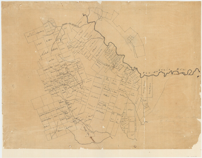
Map of the lower surveys in Robertsons Colony Sold by the State of Coahuila and Texas

Print $20.00
- Digital $50.00
Map of the lower surveys in Robertsons Colony Sold by the State of Coahuila and Texas
1834
Size: 22.0 x 28.5 inches
122
[Surveys in Austin's Colony at Matagorda Bay and along the Trespalacios and Colorado Rivers]
Print $20.00
- Digital $50.00
[Surveys in Austin's Colony at Matagorda Bay and along the Trespalacios and Colorado Rivers]
1821
Size: 31.6 x 20.5 inches
147
[Surveys in Austin's Colony along the San Antonio Road and the Colorado River]
Print $20.00
- Digital $50.00
[Surveys in Austin's Colony along the San Antonio Road and the Colorado River]
1821
Size: 17.3 x 25.6 inches
15
Austin's colony 1821-1836: In commemoration of the two hundredth birthday of Stephen F. Austin

Print $20.00
- Digital $50.00
Austin's colony 1821-1836: In commemoration of the two hundredth birthday of Stephen F. Austin
1993
Size: 24.6 x 34.5 inches
1675
Map of Surveys made in Fisher and Miller's Colony

Print $40.00
- Digital $50.00
Map of Surveys made in Fisher and Miller's Colony
1848
Size: 48.4 x 57.7 inches
16830
Connected Map of DeWitt's Colony compiled from the surveys of Byrd Lockhart

Print $40.00
- Digital $50.00
Connected Map of DeWitt's Colony compiled from the surveys of Byrd Lockhart
1831
Size: 39.2 x 54.0 inches
1942
Connected Map of Austin's Colony

Print $40.00
- Digital $50.00
Connected Map of Austin's Colony
1837
Size: 90.6 x 80.9 inches
1943
Connected Map of Austin's Colony

Print $40.00
- Digital $50.00
Connected Map of Austin's Colony
1837
Size: 90.8 x 85.6 inches
1944
Boundaries of Robertson's Colony and of Milam's Colony

Print $6.00
- Digital $50.00
Boundaries of Robertson's Colony and of Milam's Colony
1840
Size: 9.5 x 14.8 inches
1949
Map of Power and Hewetson Colony

Print $20.00
- Digital $50.00
Map of Power and Hewetson Colony
1841
Size: 34.8 x 24.3 inches
1950
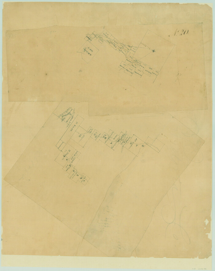
Field Notes of Mercer's Colony, Robertson, Nac[a]gdoches, Fannin, & Lamar Counties.
![1953, Field Notes of Mercer's Colony, Robertson, Nac[a]gdoches, Fannin, & Lamar Counties., General Map Collection](https://historictexasmaps.com/wmedia_w700/pdf_converted_jpg/qi_pdf_thumbnail_897.jpg)
Print $30.00
- Digital $50.00
Field Notes of Mercer's Colony, Robertson, Nac[a]gdoches, Fannin, & Lamar Counties.
1845
Size: 9.5 x 14.8 inches
1953
Map of Castro's Colony - Bexar District

Print $20.00
- Digital $50.00
Map of Castro's Colony - Bexar District
1851
Size: 36.4 x 33.1 inches
1962
Map of The Surveyed Part of Peters Colony Texas

Print $40.00
- Digital $50.00
Map of The Surveyed Part of Peters Colony Texas
1852
Size: 53.0 x 28.1 inches
1964
Map of The Surveyed Part of Peters Colony Texas

Print $40.00
- Digital $50.00
Map of The Surveyed Part of Peters Colony Texas
1852
Size: 54.1 x 42.3 inches
1965
Map of The Surveyed Part of Peters Colony Texas

Print $40.00
- Digital $50.00
Map of The Surveyed Part of Peters Colony Texas
1852
Size: 56.5 x 41.0 inches
1966
Map of The Surveyed Part of Peters Colony Texas

Print $40.00
- Digital $50.00
Map of The Surveyed Part of Peters Colony Texas
1854
Size: 53.5 x 65.9 inches
1967
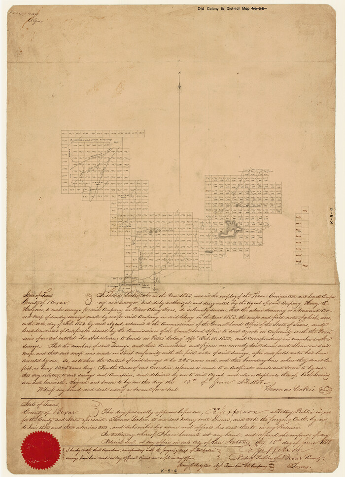
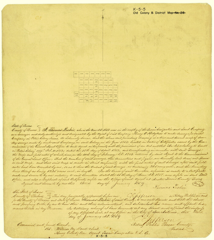
Sketch showing the Connnecting Lines run by Olliver Hedgcoxe for the Texan Emigration and Land Company connecting their Surveys made by them in Peters' Colony, Texas

Print $40.00
- Digital $50.00
Sketch showing the Connnecting Lines run by Olliver Hedgcoxe for the Texan Emigration and Land Company connecting their Surveys made by them in Peters' Colony, Texas
1854
Size: 45.8 x 61.9 inches
1969
Map of Fisher and Miller's Colony made from the records in the Office of the District Surveyor of Bexar comprising also all the recent surveys

Print $20.00
- Digital $50.00
Map of Fisher and Miller's Colony made from the records in the Office of the District Surveyor of Bexar comprising also all the recent surveys
1855
Size: 23.7 x 35.2 inches
1971
Map of a part of Fisher and Miller's Colony - Harvey's District

Print $20.00
- Digital $50.00
Map of a part of Fisher and Miller's Colony - Harvey's District
1856
Size: 15.2 x 19.8 inches
1972
Map of The Surveyed Part of Peters Colony Texas

Print $40.00
- Digital $50.00
Map of The Surveyed Part of Peters Colony Texas
1858
Size: 45.6 x 58.5 inches
1982
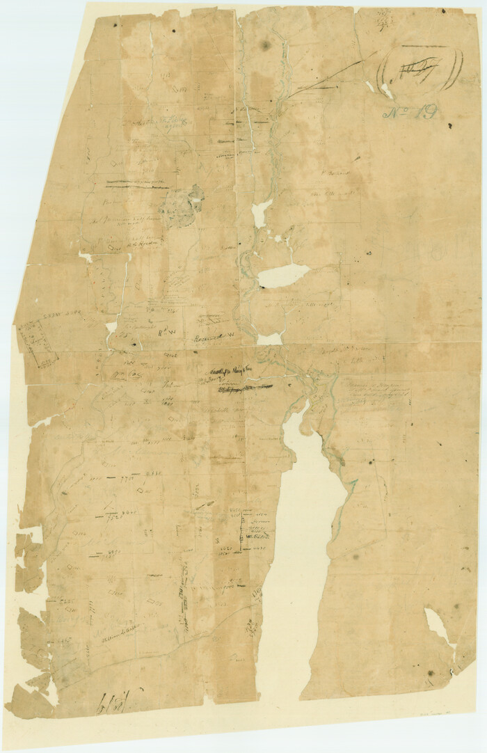
[Surveys made in Peters Colony by Thomas Leckie]
Print $20.00
- Digital $50.00
[Surveys made in Peters Colony by Thomas Leckie]
1858
Size: 22.9 x 16.6 inches
1983
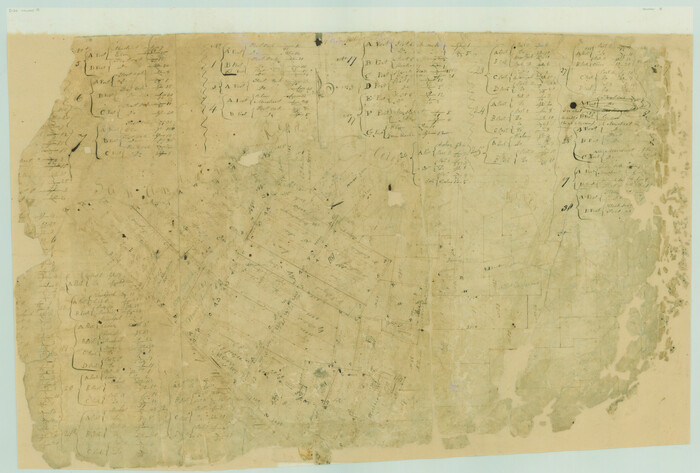
[Surveys made in Peters Colony by Thomas Leckie]
Print $20.00
- Digital $50.00
[Surveys made in Peters Colony by Thomas Leckie]
1859
Size: 15.1 x 13.4 inches
1984
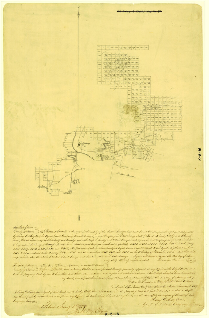
[Surveys made in Peters Colony by Dennis Corwin]
Print $20.00
- Digital $50.00
[Surveys made in Peters Colony by Dennis Corwin]
1859
Size: 24.6 x 16.2 inches
1985
[Surveys in Austin's Colony near La Bahia Road]
Print $20.00
- Digital $50.00
[Surveys in Austin's Colony near La Bahia Road]
1821
Size: 10.4 x 20.2 inches
200
[Surveys in Austin's Colony along the San Bernardo River from the mouth of Peach Creek]
Print $20.00
- Digital $50.00
[Surveys in Austin's Colony along the San Bernardo River from the mouth of Peach Creek]
1821
Size: 23.4 x 10.6 inches
209
[Surveys in Austin's Colony along New Year's Creek and near the Brazos River]
Print $20.00
- Digital $50.00
[Surveys in Austin's Colony along New Year's Creek and near the Brazos River]
1821
Size: 17.4 x 14.9 inches
218
[Surveys in McMullen and McGloin's Colony along the San Antonio River]
Print $20.00
- Digital $50.00
[Surveys in McMullen and McGloin's Colony along the San Antonio River]
1828
Size: 19.3 x 24.5 inches
30
Map of The Surveyed Part of Peters Colony Texas

Print $40.00
- Digital $50.00
Map of The Surveyed Part of Peters Colony Texas
1852
Size: 54.0 x 28.8 inches
3155
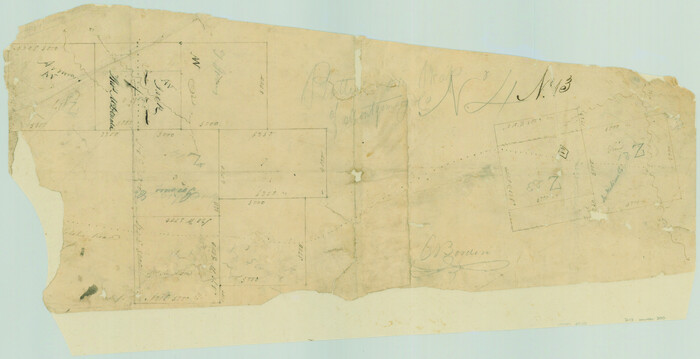
Robertson County Sketch File 11

Print $12.00
Robertson County Sketch File 11
Size: 9.4 x 7.9 inches
35398
[Surveys in DeLeon's Colony along the Garcitas River and Arenosa Creek, including the Victoria town tract]
Print $20.00
- Digital $50.00
[Surveys in DeLeon's Colony along the Garcitas River and Arenosa Creek, including the Victoria town tract]
1824
Size: 22.1 x 17.6 inches
42
Map of the lower surveys in Robertsons Colony Sold by the State of Coahuila and Texas
Print $20.00
- Digital $50.00
Map of the lower surveys in Robertsons Colony Sold by the State of Coahuila and Texas
1834
-
Size
22.0 x 28.5 inches
-
Map/Doc
122
-
Creation Date
1834
[Surveys in Austin's Colony at Matagorda Bay and along the Trespalacios and Colorado Rivers]
Print $20.00
- Digital $50.00
[Surveys in Austin's Colony at Matagorda Bay and along the Trespalacios and Colorado Rivers]
1821
-
Size
31.6 x 20.5 inches
-
Map/Doc
147
-
Creation Date
1821
[Surveys in Austin's Colony along the San Antonio Road and the Colorado River]
Print $20.00
- Digital $50.00
[Surveys in Austin's Colony along the San Antonio Road and the Colorado River]
1821
-
Size
17.3 x 25.6 inches
-
Map/Doc
15
-
Creation Date
1821
Austin's colony 1821-1836: In commemoration of the two hundredth birthday of Stephen F. Austin
Print $20.00
- Digital $50.00
Austin's colony 1821-1836: In commemoration of the two hundredth birthday of Stephen F. Austin
1993
-
Size
24.6 x 34.5 inches
-
Map/Doc
1675
-
Creation Date
1993
Map of Surveys made in Fisher and Miller's Colony
Print $40.00
- Digital $50.00
Map of Surveys made in Fisher and Miller's Colony
1848
-
Size
48.4 x 57.7 inches
-
Map/Doc
16830
-
Creation Date
1848
Connected Map of DeWitt's Colony compiled from the surveys of Byrd Lockhart
Print $40.00
- Digital $50.00
Connected Map of DeWitt's Colony compiled from the surveys of Byrd Lockhart
1831
-
Size
39.2 x 54.0 inches
-
Map/Doc
1942
-
Creation Date
1831
Connected Map of Austin's Colony
Print $40.00
- Digital $50.00
Connected Map of Austin's Colony
1837
-
Size
90.6 x 80.9 inches
-
Map/Doc
1943
-
Creation Date
1837
Connected Map of Austin's Colony
Print $40.00
- Digital $50.00
Connected Map of Austin's Colony
1837
1892 certified tracing of 1833-1837 original
-
Size
90.8 x 85.6 inches
-
Map/Doc
1944
-
Creation Date
1837
Boundaries of Robertson's Colony and of Milam's Colony
Print $6.00
- Digital $50.00
Boundaries of Robertson's Colony and of Milam's Colony
1840
-
Size
9.5 x 14.8 inches
-
Map/Doc
1949
-
Creation Date
1840
Map of Power and Hewetson Colony
Print $20.00
- Digital $50.00
Map of Power and Hewetson Colony
1841
-
Size
34.8 x 24.3 inches
-
Map/Doc
1950
-
Creation Date
1841
Field Notes of Mercer's Colony, Robertson, Nac[a]gdoches, Fannin, & Lamar Counties.
Print $30.00
- Digital $50.00
Field Notes of Mercer's Colony, Robertson, Nac[a]gdoches, Fannin, & Lamar Counties.
1845
-
Size
9.5 x 14.8 inches
-
Map/Doc
1953
-
Creation Date
1845
Map of Castro's Colony - Bexar District
Print $20.00
- Digital $50.00
Map of Castro's Colony - Bexar District
1851
-
Size
36.4 x 33.1 inches
-
Map/Doc
1962
-
Creation Date
1851
Map of The Surveyed Part of Peters Colony Texas
Print $40.00
- Digital $50.00
Map of The Surveyed Part of Peters Colony Texas
1852
-
Size
53.0 x 28.1 inches
-
Map/Doc
1964
-
Creation Date
1852
Map of The Surveyed Part of Peters Colony Texas
Print $40.00
- Digital $50.00
Map of The Surveyed Part of Peters Colony Texas
1852
-
Size
54.1 x 42.3 inches
-
Map/Doc
1965
-
Creation Date
1852
Map of The Surveyed Part of Peters Colony Texas
Print $40.00
- Digital $50.00
Map of The Surveyed Part of Peters Colony Texas
1852
-
Size
56.5 x 41.0 inches
-
Map/Doc
1966
-
Creation Date
1852
Map of The Surveyed Part of Peters Colony Texas
Print $40.00
- Digital $50.00
Map of The Surveyed Part of Peters Colony Texas
1854
-
Size
53.5 x 65.9 inches
-
Map/Doc
1967
-
Creation Date
1854
Sketch showing the Connnecting Lines run by Olliver Hedgcoxe for the Texan Emigration and Land Company connecting their Surveys made by them in Peters' Colony, Texas
Print $40.00
- Digital $50.00
Sketch showing the Connnecting Lines run by Olliver Hedgcoxe for the Texan Emigration and Land Company connecting their Surveys made by them in Peters' Colony, Texas
1854
-
Size
45.8 x 61.9 inches
-
Map/Doc
1969
-
Creation Date
1854
Map of Fisher and Miller's Colony made from the records in the Office of the District Surveyor of Bexar comprising also all the recent surveys
Print $20.00
- Digital $50.00
Map of Fisher and Miller's Colony made from the records in the Office of the District Surveyor of Bexar comprising also all the recent surveys
1855
-
Size
23.7 x 35.2 inches
-
Map/Doc
1971
-
Creation Date
1855
Map of a part of Fisher and Miller's Colony - Harvey's District
Print $20.00
- Digital $50.00
Map of a part of Fisher and Miller's Colony - Harvey's District
1856
-
Size
15.2 x 19.8 inches
-
Map/Doc
1972
-
Creation Date
1856
Map of The Surveyed Part of Peters Colony Texas
Print $40.00
- Digital $50.00
Map of The Surveyed Part of Peters Colony Texas
1858
-
Size
45.6 x 58.5 inches
-
Map/Doc
1982
-
Creation Date
1858
[Surveys made in Peters Colony by Thomas Leckie]
Print $20.00
- Digital $50.00
[Surveys made in Peters Colony by Thomas Leckie]
1858
-
Size
22.9 x 16.6 inches
-
Map/Doc
1983
-
Creation Date
1858
[Surveys made in Peters Colony by Thomas Leckie]
Print $20.00
- Digital $50.00
[Surveys made in Peters Colony by Thomas Leckie]
1859
-
Size
15.1 x 13.4 inches
-
Map/Doc
1984
-
Creation Date
1859
[Surveys made in Peters Colony by Dennis Corwin]
Print $20.00
- Digital $50.00
[Surveys made in Peters Colony by Dennis Corwin]
1859
-
Size
24.6 x 16.2 inches
-
Map/Doc
1985
-
Creation Date
1859
[Surveys in Austin's Colony near La Bahia Road]
Print $20.00
- Digital $50.00
[Surveys in Austin's Colony near La Bahia Road]
1821
-
Size
10.4 x 20.2 inches
-
Map/Doc
200
-
Creation Date
1821
[Surveys in Austin's Colony along the San Bernardo River from the mouth of Peach Creek]
Print $20.00
- Digital $50.00
[Surveys in Austin's Colony along the San Bernardo River from the mouth of Peach Creek]
1821
-
Size
23.4 x 10.6 inches
-
Map/Doc
209
-
Creation Date
1821
[Surveys in Austin's Colony along New Year's Creek and near the Brazos River]
Print $20.00
- Digital $50.00
[Surveys in Austin's Colony along New Year's Creek and near the Brazos River]
1821
-
Size
17.4 x 14.9 inches
-
Map/Doc
218
-
Creation Date
1821
[Surveys in McMullen and McGloin's Colony along the San Antonio River]
Print $20.00
- Digital $50.00
[Surveys in McMullen and McGloin's Colony along the San Antonio River]
1828
-
Size
19.3 x 24.5 inches
-
Map/Doc
30
-
Creation Date
1828
Map of The Surveyed Part of Peters Colony Texas
Print $40.00
- Digital $50.00
Map of The Surveyed Part of Peters Colony Texas
1852
-
Size
54.0 x 28.8 inches
-
Map/Doc
3155
-
Creation Date
1852
Robertson County Sketch File 11
Print $12.00
Robertson County Sketch File 11
-
Size
9.4 x 7.9 inches
-
Map/Doc
35398
[Surveys in DeLeon's Colony along the Garcitas River and Arenosa Creek, including the Victoria town tract]
Print $20.00
- Digital $50.00
[Surveys in DeLeon's Colony along the Garcitas River and Arenosa Creek, including the Victoria town tract]
1824
-
Size
22.1 x 17.6 inches
-
Map/Doc
42
-
Creation Date
1824