[Section of] El Nuevo Mexico y Tierras Adyacentes Mapa Levantado para la demarcacion de los Limites de los Dominios Españoles y de los Estados Unidos

[Section of] El Nuevo Mexico y Tierras Adyacentes Mapa Levantado para la demarcacion de los Limites de los Dominios Españoles y de los Estados Unidos
1811
Size: 17.9 x 26.7 inches
97484
[Section of] Carte du Mexique et de la Nouvelle Espagne
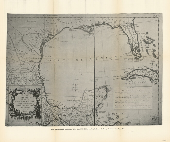
[Section of] Carte du Mexique et de la Nouvelle Espagne
1779
Size: 14.0 x 16.7 inches
97485
United States of America corrected & improved from the best authorities

Print $20.00
- Digital $50.00
United States of America corrected & improved from the best authorities
1820
Size: 17.5 x 26.3 inches
93953
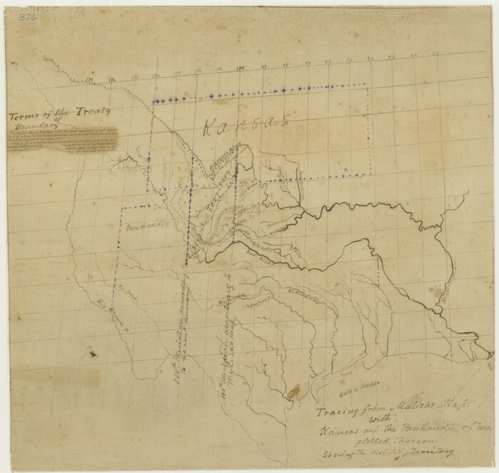
Tracing From [Melish's] Map with Kansas and the Panhandle of Texas plotted thereon Showing the disputed Territory
Print $20.00
Tracing From [Melish's] Map with Kansas and the Panhandle of Texas plotted thereon Showing the disputed Territory
1818
Size: 18.8 x 19.8 inches
76190
The Western Coast of Louisiana and The Coast of New Leon

Print $20.00
- Digital $50.00
The Western Coast of Louisiana and The Coast of New Leon
1775
Size: 21.1 x 28.7 inches
93705
The United States of North America with the British Territories and Those of Spain, according to the Treaty of 1784

Print $20.00
- Digital $50.00
The United States of North America with the British Territories and Those of Spain, according to the Treaty of 1784
1796
Size: 23.6 x 30.8 inches
95738
The Continent and Islands of the West Indies

Print $20.00
The Continent and Islands of the West Indies
1804
Size: 22.8 x 26.0 inches
79318

Spanish land grants (other than porciones) in the trans-Nueces

Spanish land grants (other than porciones) in the trans-Nueces
2009
Size: 11.0 x 8.5 inches
94046
Spanish and Mexican Land Grants in Texas

Print $20.00
Spanish and Mexican Land Grants in Texas
2015
Size: 34.0 x 44.0 inches
93755
Spanish Province of Texas compiled from map on file among archives at Saltillo

Print $20.00
- Digital $50.00
Spanish Province of Texas compiled from map on file among archives at Saltillo
1897
Size: 13.6 x 16.0 inches
93412
Spanish Province of Texas Compiled from map on file among archives at Saltillo

Print $20.00
Spanish Province of Texas Compiled from map on file among archives at Saltillo
Size: 13.8 x 16.2 inches
79742
Spanish North America

Print $20.00
- Digital $50.00
Spanish North America
1814
Size: 21.9 x 29.8 inches
89224
Spanish Dominions in North America, Northern Part

Print $20.00
- Digital $50.00
Spanish Dominions in North America, Northern Part
1811
Size: 22.1 x 30.5 inches
95133
Segunda parte del Mapa, que comprende la Frontera, de los Dominios del Rey, en la America Septentrional

Print $40.00
- Digital $50.00
Segunda parte del Mapa, que comprende la Frontera, de los Dominios del Rey, en la America Septentrional
1769
Size: 26.7 x 63.8 inches
4667
Reyno de la Nueva España a Principios del Siglo XIX

Print $20.00
- Digital $50.00
Reyno de la Nueva España a Principios del Siglo XIX
1885
Size: 25.6 x 32.7 inches
93751
Provincias internas del Reyno de Nuevo España

Print $20.00
Provincias internas del Reyno de Nuevo España
1790
Size: 31.0 x 24.0 inches
95313
Primera parte del Mapa, que comprende la Frontera, de los Dominios del Rey, en la America Septentrional

Print $40.00
- Digital $50.00
Primera parte del Mapa, que comprende la Frontera, de los Dominios del Rey, en la America Septentrional
1769
Size: 25.8 x 63.2 inches
3062
Presidio de San Antonio de Bejar y Villa de San Fernando

Print $20.00
- Digital $50.00
Presidio de San Antonio de Bejar y Villa de San Fernando
1986
Size: 21.8 x 26.0 inches
87386
Political Essay on the Kingdom of New Spain Vol. 4

Political Essay on the Kingdom of New Spain Vol. 4
1822
97389
Political Essay on the Kingdom of New Spain Vol. 3

Political Essay on the Kingdom of New Spain Vol. 3
1822
97388
Political Essay on the Kingdom of New Spain Vol. 2, Third Edition

Political Essay on the Kingdom of New Spain Vol. 2, Third Edition
1822
97387
Political Essay on the Kingdom of New Spain Vol. 1, Third Edition

Political Essay on the Kingdom of New Spain Vol. 1, Third Edition
1822
97386
Plano del Presidio de Nra. Senora del Pilar de los Adaes, Capital de la Provincia de los Tejas situado en 32 grados y 15 minutos de Latitud Boreal, y en 285° y 52' de Longitud respecto del Meridiano de Tenerife

Plano del Presidio de Nra. Senora del Pilar de los Adaes, Capital de la Provincia de los Tejas situado en 32 grados y 15 minutos de Latitud Boreal, y en 285° y 52' de Longitud respecto del Meridiano de Tenerife
Size: 16.9 x 21.4 inches
96563
Plano del Presidio de Nra Senora del Pilar de los Adaes

Plano del Presidio de Nra Senora del Pilar de los Adaes
1766
Size: 7.3 x 9.2 inches
96517
[Section of] El Nuevo Mexico y Tierras Adyacentes Mapa Levantado para la demarcacion de los Limites de los Dominios Españoles y de los Estados Unidos
[Section of] El Nuevo Mexico y Tierras Adyacentes Mapa Levantado para la demarcacion de los Limites de los Dominios Españoles y de los Estados Unidos
1811
-
Size
17.9 x 26.7 inches
-
Map/Doc
97484
-
Creation Date
1811
[Section of] Carte du Mexique et de la Nouvelle Espagne
[Section of] Carte du Mexique et de la Nouvelle Espagne
1779
-
Size
14.0 x 16.7 inches
-
Map/Doc
97485
-
Creation Date
1779
United States of America corrected & improved from the best authorities
Print $20.00
- Digital $50.00
United States of America corrected & improved from the best authorities
1820
-
Size
17.5 x 26.3 inches
-
Map/Doc
93953
-
Creation Date
1820
Tracing From [Melish's] Map with Kansas and the Panhandle of Texas plotted thereon Showing the disputed Territory
Print $20.00
Tracing From [Melish's] Map with Kansas and the Panhandle of Texas plotted thereon Showing the disputed Territory
1818
-
Size
18.8 x 19.8 inches
-
Map/Doc
76190
-
Creation Date
1818
The Western Coast of Louisiana and The Coast of New Leon
Print $20.00
- Digital $50.00
The Western Coast of Louisiana and The Coast of New Leon
1775
-
Size
21.1 x 28.7 inches
-
Map/Doc
93705
-
Creation Date
1775
The United States of North America with the British Territories and Those of Spain, according to the Treaty of 1784
Print $20.00
- Digital $50.00
The United States of North America with the British Territories and Those of Spain, according to the Treaty of 1784
1796
-
Size
23.6 x 30.8 inches
-
Map/Doc
95738
-
Creation Date
1796
The Making of America - Texas

The Making of America - Texas
1986
-
Size
20.7 x 27.3 inches
-
Map/Doc
96825
-
Creation Date
1986
The Land Grants of Texas

Print $20.00
The Land Grants of Texas
2014
-
Size
28.0 x 36.2 inches
-
Map/Doc
93698
-
Creation Date
2014
The Genealogy of the Alamo

The Genealogy of the Alamo
2026
-
Size
17.0 x 11.0 inches
-
Map/Doc
97523
-
Creation Date
2026
The Continent and Islands of the West Indies
Print $20.00
The Continent and Islands of the West Indies
1804
-
Size
22.8 x 26.0 inches
-
Map/Doc
79318
-
Creation Date
1804
The Adams-Onís Treaty

The Adams-Onís Treaty
2022
-
Size
8.5 x 11.0 inches
-
Map/Doc
96978
-
Creation Date
2022
Spanish land grants (other than porciones) in the trans-Nueces
Spanish land grants (other than porciones) in the trans-Nueces
2009
-
Size
11.0 x 8.5 inches
-
Map/Doc
94046
-
Creation Date
2009
Spanish and Mexican Land Grants in Texas
Print $20.00
Spanish and Mexican Land Grants in Texas
2015
-
Size
34.0 x 44.0 inches
-
Map/Doc
93755
-
Creation Date
2015
Spanish Province of Texas compiled from map on file among archives at Saltillo
Print $20.00
- Digital $50.00
Spanish Province of Texas compiled from map on file among archives at Saltillo
1897
-
Size
13.6 x 16.0 inches
-
Map/Doc
93412
-
Creation Date
1897
Spanish Province of Texas Compiled from map on file among archives at Saltillo
Print $20.00
Spanish Province of Texas Compiled from map on file among archives at Saltillo
-
Size
13.8 x 16.2 inches
-
Map/Doc
79742
Spanish North America
Print $20.00
- Digital $50.00
Spanish North America
1814
-
Size
21.9 x 29.8 inches
-
Map/Doc
89224
-
Creation Date
1814
Spanish Dominions in North America, Northern Part
Print $20.00
- Digital $50.00
Spanish Dominions in North America, Northern Part
1811
-
Size
22.1 x 30.5 inches
-
Map/Doc
95133
-
Creation Date
1811
Segunda parte del Mapa, que comprende la Frontera, de los Dominios del Rey, en la America Septentrional
Print $40.00
- Digital $50.00
Segunda parte del Mapa, que comprende la Frontera, de los Dominios del Rey, en la America Septentrional
1769
-
Size
26.7 x 63.8 inches
-
Map/Doc
4667
-
Creation Date
1769
Reyno de la Nueva España a Principios del Siglo XIX
Print $20.00
- Digital $50.00
Reyno de la Nueva España a Principios del Siglo XIX
1885
-
Size
25.6 x 32.7 inches
-
Map/Doc
93751
-
Creation Date
1885
Provincias internas del Reyno de Nuevo España
Print $20.00
Provincias internas del Reyno de Nuevo España
1790
-
Size
31.0 x 24.0 inches
-
Map/Doc
95313
-
Creation Date
1790
Provincia de Texas

Provincia de Texas
1807
This map represented a significant advance in the depiction of Texas waterways, and it was an...
-
Size
9.7 x 13.4 inches
-
Map/Doc
94456
-
Creation Date
1807
Primera parte del Mapa, que comprende la Frontera, de los Dominios del Rey, en la America Septentrional
Print $40.00
- Digital $50.00
Primera parte del Mapa, que comprende la Frontera, de los Dominios del Rey, en la America Septentrional
1769
-
Size
25.8 x 63.2 inches
-
Map/Doc
3062
-
Creation Date
1769
Presidio de San Antonio de Bejar y Villa de San Fernando
Print $20.00
- Digital $50.00
Presidio de San Antonio de Bejar y Villa de San Fernando
1986
-
Size
21.8 x 26.0 inches
-
Map/Doc
87386
-
Creation Date
1986
Political Essay on the Kingdom of New Spain Vol. 4
Political Essay on the Kingdom of New Spain Vol. 4
1822
Containing Researches relative to the Geography of Mexico, The Extent of its Surface and its...
-
Map/Doc
97389
-
Creation Date
1822
Political Essay on the Kingdom of New Spain Vol. 3
Political Essay on the Kingdom of New Spain Vol. 3
1822
Containing Researches relative to the Geography of Mexico, The Extent of its Surface and its...
-
Map/Doc
97388
-
Creation Date
1822
Political Essay on the Kingdom of New Spain Vol. 2, Third Edition
Political Essay on the Kingdom of New Spain Vol. 2, Third Edition
1822
Containing Researches relative to the Geography of Mexico, The Extent of its Surface and its...
-
Map/Doc
97387
-
Creation Date
1822
Political Essay on the Kingdom of New Spain Vol. 1, Third Edition
Political Essay on the Kingdom of New Spain Vol. 1, Third Edition
1822
Containing Researches relative to the Geography of Mexico, The Extent of its Surface and its...
-
Map/Doc
97386
-
Creation Date
1822
Plano del Presidio de Nra. Senora del Pilar de los Adaes, Capital de la Provincia de los Tejas situado en 32 grados y 15 minutos de Latitud Boreal, y en 285° y 52' de Longitud respecto del Meridiano de Tenerife
Plano del Presidio de Nra. Senora del Pilar de los Adaes, Capital de la Provincia de los Tejas situado en 32 grados y 15 minutos de Latitud Boreal, y en 285° y 52' de Longitud respecto del Meridiano de Tenerife
-
Size
16.9 x 21.4 inches
-
Map/Doc
96563
Plano del Presidio de Nra Senora del Pilar de los Adaes
Plano del Presidio de Nra Senora del Pilar de los Adaes
1766
-
Size
7.3 x 9.2 inches
-
Map/Doc
96517
-
Creation Date
1766