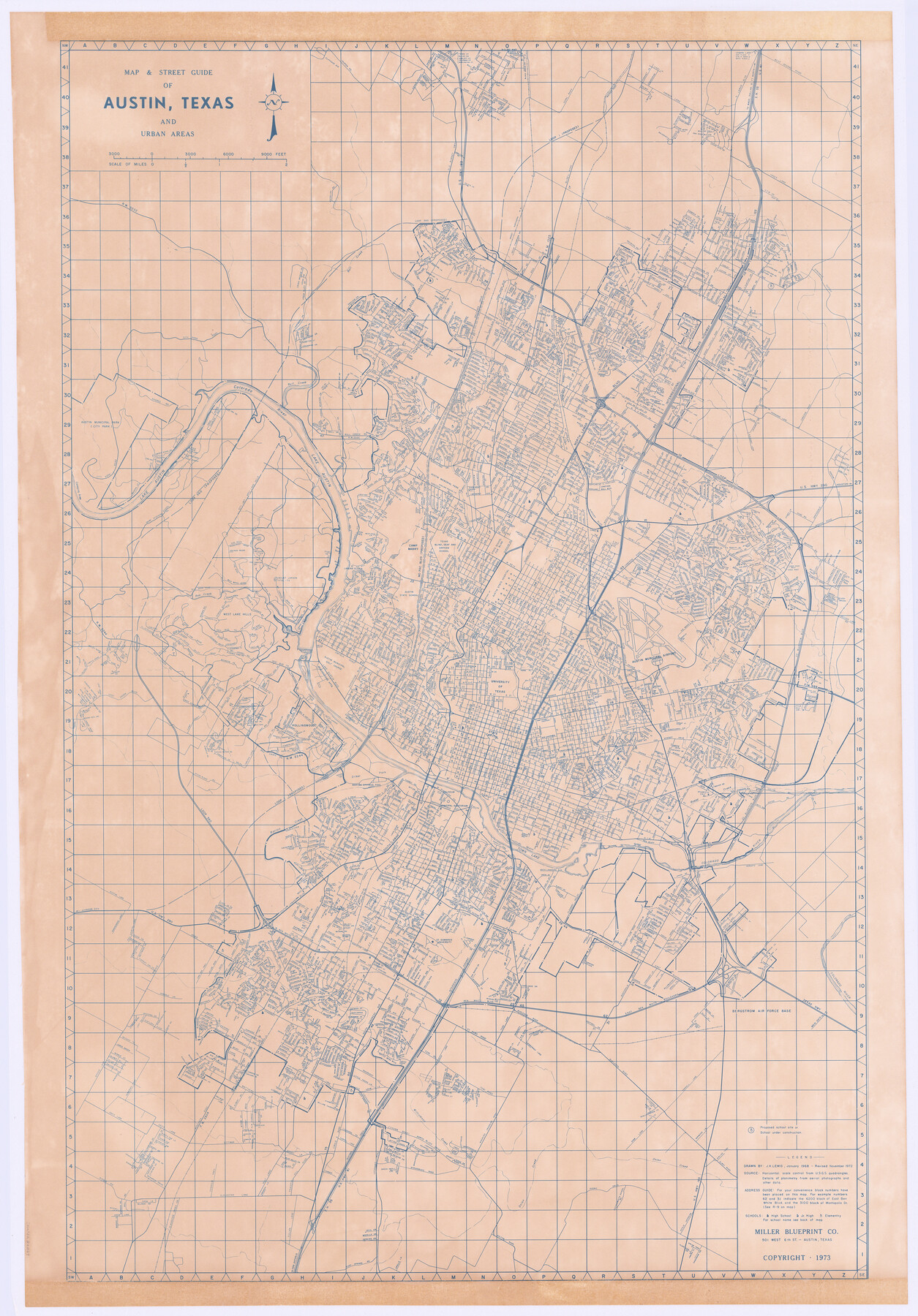
Map and Street Guide of Austin, Texas and Urban Areas
-
Map/Doc
82029
-
Collection
General Map Collection
-
Object Dates
1972 (Creation Date)
-
People and Organizations
Miller Blueprint Company (Publisher)
Miller Blueprint Company (Printer)
J.K. Lewis (Draftsman)
-
Counties
Travis
-
Subjects
City
-
Height x Width
48.6 x 33.9 inches
123.4 x 86.1 cm
-
Medium
paper, etching/engraving/lithograph
-
Comments
Available for research only. Copyrighted and unavailable for duplication.
Map noted as drawn in January 1968 and revised November 1972.
Received in office June 25, 2002.
Part of: General Map Collection
Right-of-Way and Track Map, Houston and Brazos Valley Ry. Co. operated by the Houston and Brazos Valley Ry. Co.

Print $40.00
- Digital $50.00
Right-of-Way and Track Map, Houston and Brazos Valley Ry. Co. operated by the Houston and Brazos Valley Ry. Co.
1918
Size 24.9 x 56.5 inches
Map/Doc 64608
McLennan County Working Sketch 2

Print $20.00
- Digital $50.00
McLennan County Working Sketch 2
1941
Size 21.8 x 30.0 inches
Map/Doc 70695
Sabine Pass and mouth of the River Sabine in the sea

Print $20.00
- Digital $50.00
Sabine Pass and mouth of the River Sabine in the sea
1840
Size 23.8 x 19.0 inches
Map/Doc 94268

Reeves County Sketch File 3

Print $8.00
- Digital $50.00
Reeves County Sketch File 3
Size 14.4 x 8.8 inches
Map/Doc 35188
Nueces County NRC Article 33.136 Sketch 2

Print $20.00
- Digital $50.00
Nueces County NRC Article 33.136 Sketch 2
2002
Size 29.3 x 44.4 inches
Map/Doc 61622
Hamilton County Sketch File C

Print $6.00
- Digital $50.00
Hamilton County Sketch File C
Size 12.4 x 11.0 inches
Map/Doc 24950
Harris County Sketch File E

Print $4.00
- Digital $50.00
Harris County Sketch File E
1860
Size 7.6 x 12.1 inches
Map/Doc 25315
Treaty to Resolve Pending Boundary Differences and Maintain the Rio Grande and Colorado River as the International Boundary Between the United States of American and Mexico

Print $20.00
- Digital $50.00
Treaty to Resolve Pending Boundary Differences and Maintain the Rio Grande and Colorado River as the International Boundary Between the United States of American and Mexico
1970
Size 10.8 x 29.8 inches
Map/Doc 83106
Hays County Sketch File 10

Print $4.00
- Digital $50.00
Hays County Sketch File 10
1862
Size 8.2 x 10.7 inches
Map/Doc 26214
Maps of Gulf Intracoastal Waterway, Texas - Sabine River to the Rio Grande and connecting waterways including ship channels

Print $20.00
- Digital $50.00
Maps of Gulf Intracoastal Waterway, Texas - Sabine River to the Rio Grande and connecting waterways including ship channels
1966
Size 14.5 x 22.2 inches
Map/Doc 61932
El Paso County Sketch File 10

Print $52.00
- Digital $50.00
El Paso County Sketch File 10
1890
Size 8.4 x 5.4 inches
Map/Doc 21974
You may also like
Liberty County Sketch File 30

Print $6.00
- Digital $50.00
Liberty County Sketch File 30
Size 10.5 x 11.3 inches
Map/Doc 29957
Flight Mission No. CGI-4N, Frame 179, Cameron County

Print $20.00
- Digital $50.00
Flight Mission No. CGI-4N, Frame 179, Cameron County
1955
Size 18.5 x 22.2 inches
Map/Doc 84682
Crockett County Sketch File 50a

Print $11.00
- Digital $50.00
Crockett County Sketch File 50a
Size 14.0 x 9.3 inches
Map/Doc 19807
General Highway Map, Hartley County, Texas

Print $20.00
General Highway Map, Hartley County, Texas
1961
Size 24.8 x 18.2 inches
Map/Doc 79510
Edwards County Sketch File 7

Print $26.00
- Digital $50.00
Edwards County Sketch File 7
1880
Size 8.0 x 7.9 inches
Map/Doc 21684
San Patricio County

Print $40.00
- Digital $50.00
San Patricio County
1939
Size 40.3 x 49.3 inches
Map/Doc 95634
Foard County Aerial Photograph Index Sheet 4

Print $20.00
- Digital $50.00
Foard County Aerial Photograph Index Sheet 4
1950
Size 18.6 x 16.3 inches
Map/Doc 83691
Map of a part of Fisher and Miller's Colony - Harvey's District

Print $20.00
- Digital $50.00
Map of a part of Fisher and Miller's Colony - Harvey's District
1856
Size 15.2 x 19.8 inches
Map/Doc 1972
Zapata County Working Sketch 18

Print $20.00
- Digital $50.00
Zapata County Working Sketch 18
Size 43.2 x 29.1 inches
Map/Doc 62069
Morris County Rolled Sketch 2A

Print $20.00
- Digital $50.00
Morris County Rolled Sketch 2A
Size 36.0 x 25.0 inches
Map/Doc 10236
Current Miscellaneous File 74

Print $14.00
- Digital $50.00
Current Miscellaneous File 74
1850
Size 11.2 x 8.7 inches
Map/Doc 74181
Chambers County Working Sketch 24
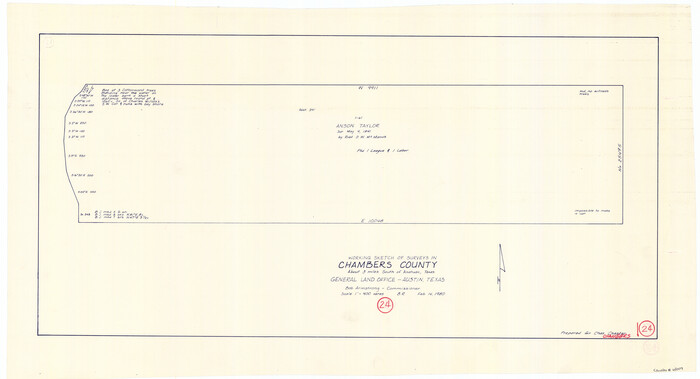
Print $20.00
- Digital $50.00
Chambers County Working Sketch 24
1980
Size 17.5 x 32.3 inches
Map/Doc 68007