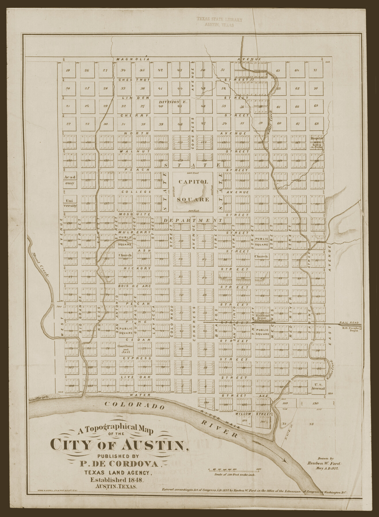
A Topographical Map of the City of Austin
A-6-49, K-7-2
-
Map/Doc
93685
-
Collection
General Map Collection
-
Object Dates
1872 (Creation Date)
2014/5/21 (File Date)
-
People and Organizations
P. De Cordova (Publisher)
George W. Averell Lithography and Print (Printer)
Reuben W. Ford (Draftsman)
-
Counties
Travis
-
Subjects
City
-
Height x Width
20.6 x 15.1 inches
52.3 x 38.4 cm
-
Medium
paper, manuscript
-
Comments
See Map# 4821 for black and white negative from which this sepia print was made.
-
Features
Waller Creek
Shoal Creek
R[ail] R[oad] Freight Depot
Railroad Depot for Passengers
Colorado River
Austin
Part of: General Map Collection
Archer County Working Sketch 20

Print $20.00
- Digital $50.00
Archer County Working Sketch 20
1975
Size 31.7 x 24.4 inches
Map/Doc 67161
Kimble County Working Sketch 82

Print $20.00
- Digital $50.00
Kimble County Working Sketch 82
1971
Size 43.3 x 27.7 inches
Map/Doc 70150
Crockett County Rolled Sketch 67

Print $20.00
- Digital $50.00
Crockett County Rolled Sketch 67
1948
Size 34.2 x 21.7 inches
Map/Doc 5610
Newton County Sketch File 11

Print $4.00
- Digital $50.00
Newton County Sketch File 11
1876
Size 7.9 x 12.7 inches
Map/Doc 32380
Pecos County Rolled Sketch 158

Print $20.00
- Digital $50.00
Pecos County Rolled Sketch 158
1961
Size 21.9 x 27.4 inches
Map/Doc 7284
Montgomery County Working Sketch 72

Print $20.00
- Digital $50.00
Montgomery County Working Sketch 72
1979
Size 17.2 x 32.4 inches
Map/Doc 71179
Maverick County Sketch File 16

Print $20.00
- Digital $50.00
Maverick County Sketch File 16
1887
Size 14.1 x 34.5 inches
Map/Doc 12051
Kendall County Working Sketch 6

Print $20.00
- Digital $50.00
Kendall County Working Sketch 6
1947
Size 42.6 x 24.8 inches
Map/Doc 66678
Johnson County

Print $20.00
- Digital $50.00
Johnson County
1943
Size 43.3 x 40.2 inches
Map/Doc 95549
[Sketch for Mineral Application 13436 - 13441]
![65581, [Sketch for Mineral Application 13436 - 13441], General Map Collection](https://historictexasmaps.com/wmedia_w700/maps/65581.tif.jpg)
Print $40.00
- Digital $50.00
[Sketch for Mineral Application 13436 - 13441]
1925
Size 56.8 x 42.4 inches
Map/Doc 65581
Flight Mission No. DIX-10P, Frame 169, Aransas County

Print $20.00
- Digital $50.00
Flight Mission No. DIX-10P, Frame 169, Aransas County
1956
Size 18.7 x 22.3 inches
Map/Doc 83959
Val Verde County Sketch File 44A

Print $10.00
- Digital $50.00
Val Verde County Sketch File 44A
1940
Size 14.5 x 8.8 inches
Map/Doc 39311
You may also like
Burnet County Working Sketch 8

Print $20.00
- Digital $50.00
Burnet County Working Sketch 8
1973
Size 27.2 x 28.0 inches
Map/Doc 67851
Harris County Rolled Sketch 88

Print $20.00
- Digital $50.00
Harris County Rolled Sketch 88
1937
Size 34.8 x 22.8 inches
Map/Doc 6127
Cameron County Rolled Sketch 5

Print $20.00
- Digital $50.00
Cameron County Rolled Sketch 5
Size 35.8 x 38.8 inches
Map/Doc 8562
Terrell County Sketch File 34

Print $12.00
- Digital $50.00
Terrell County Sketch File 34
1960
Size 9.7 x 8.5 inches
Map/Doc 37984
Nueces County Rolled Sketch 127

Print $20.00
- Digital $50.00
Nueces County Rolled Sketch 127
1998
Size 24.1 x 36.4 inches
Map/Doc 7162
Flight Mission No. DAG-21K, Frame 43, Matagorda County

Print $20.00
- Digital $50.00
Flight Mission No. DAG-21K, Frame 43, Matagorda County
1952
Size 18.9 x 22.6 inches
Map/Doc 86410
Flight Mission No. BQR-22K, Frame 39, Brazoria County

Print $20.00
- Digital $50.00
Flight Mission No. BQR-22K, Frame 39, Brazoria County
1953
Size 18.8 x 22.4 inches
Map/Doc 84123
Terry County Sketch File 13

Print $20.00
- Digital $50.00
Terry County Sketch File 13
Size 43.2 x 10.2 inches
Map/Doc 10397
[W. E. Halsell's Subdivision of Capitol Leagues, Blocks T1,T2, T3, and S2]
![92164, [W. E. Halsell's Subdivision of Capitol Leagues, Blocks T1,T2, T3, and S2], Twichell Survey Records](https://historictexasmaps.com/wmedia_w700/maps/92164-1.tif.jpg)
Print $20.00
- Digital $50.00
[W. E. Halsell's Subdivision of Capitol Leagues, Blocks T1,T2, T3, and S2]
1907
Size 20.5 x 16.5 inches
Map/Doc 92164
Glasscock County Sketch File 2

Print $20.00
- Digital $50.00
Glasscock County Sketch File 2
1931
Size 35.1 x 16.2 inches
Map/Doc 11559
Menard County Sketch File 11

Print $8.00
- Digital $50.00
Menard County Sketch File 11
1892
Size 12.8 x 8.3 inches
Map/Doc 31496
Stephens County Working Sketch 16

Print $20.00
- Digital $50.00
Stephens County Working Sketch 16
1968
Size 21.4 x 30.4 inches
Map/Doc 63959