Hudspeth County Sketch File 23
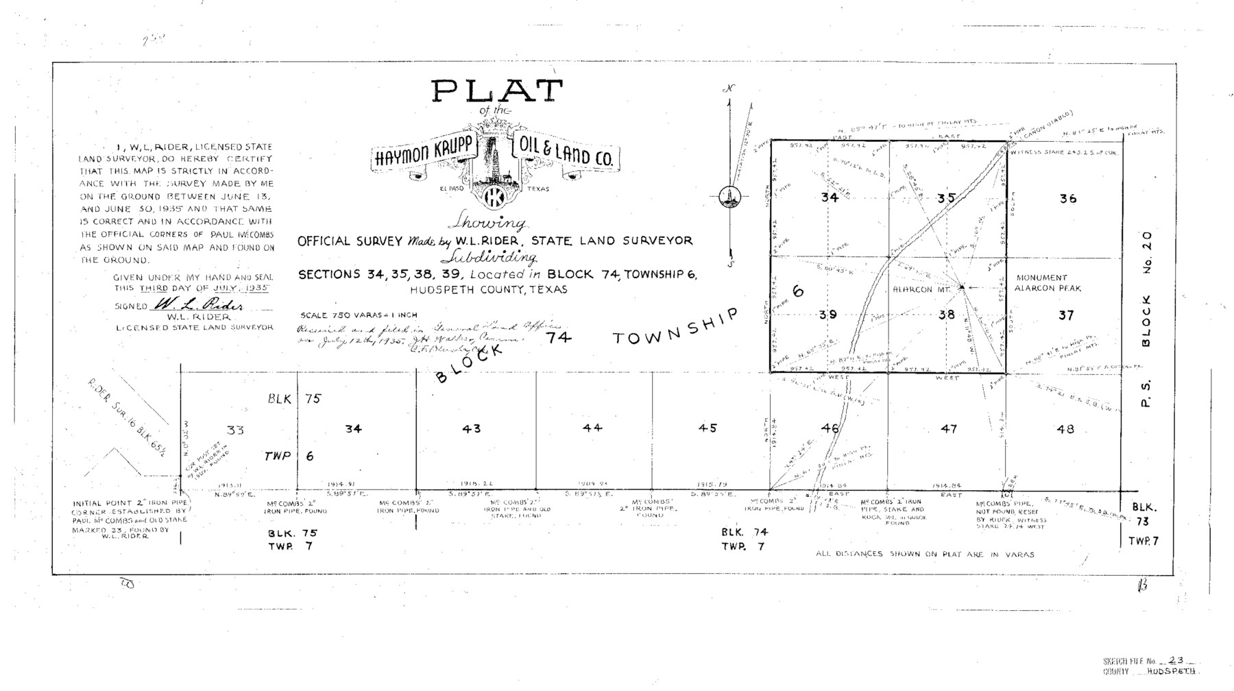
Plat of the Haymon Krup Oil & Land Co. Subdividing Sections 34, 35, 38, 39 Located in Block 74, Township 6, Hudspeth County, Texas
-
Map/Doc
11801
-
Collection
General Map Collection
-
Object Dates
7/3/1935 (Creation Date)
7/12/1935 (File Date)
6/13/1935 (Survey Date)
6/30/1935 (Survey Date)
-
People and Organizations
W.L. Rider (Surveyor/Engineer)
Paul McCombs (Surveyor/Engineer)
-
Counties
Hudspeth
-
Subjects
Surveying Sketch File
-
Height x Width
15.1 x 26.9 inches
38.4 x 68.3 cm
-
Medium
paper, print
-
Scale
1:750
-
Comments
See Hudspeth County Sketch File 22 (26974) for surveyor's statement.
-
Features
Canon Diablo
Alarcon Mountain
Related maps
Hudspeth County Sketch File 22

Print $10.00
- Digital $50.00
Hudspeth County Sketch File 22
1935
Size 11.2 x 8.7 inches
Map/Doc 26974
Part of: General Map Collection
Lavaca County Boundary File 58

Print $20.00
- Digital $50.00
Lavaca County Boundary File 58
Size 8.5 x 7.1 inches
Map/Doc 56259
Southern Pacific Transportation Company, Right of Way and Track Map, Beeville Branch

Print $40.00
- Digital $50.00
Southern Pacific Transportation Company, Right of Way and Track Map, Beeville Branch
Size 24.1 x 56.1 inches
Map/Doc 76163
Kent County Working Sketch 3b

Print $20.00
- Digital $50.00
Kent County Working Sketch 3b
1948
Size 24.9 x 23.3 inches
Map/Doc 70010
Map of Asylum Lands

Print $20.00
- Digital $50.00
Map of Asylum Lands
1857
Size 22.0 x 29.1 inches
Map/Doc 2214
[Sketch for Mineral Application 33721 - 33725 Incl. - Padre and Mustang Island]
![65664, [Sketch for Mineral Application 33721 - 33725 Incl. - Padre and Mustang Island], General Map Collection](https://historictexasmaps.com/wmedia_w700/maps/65664.tif.jpg)
Print $20.00
- Digital $50.00
[Sketch for Mineral Application 33721 - 33725 Incl. - Padre and Mustang Island]
Size 42.3 x 22.6 inches
Map/Doc 65664
Hays County Rolled Sketch 31

Print $20.00
- Digital $50.00
Hays County Rolled Sketch 31
2001
Size 24.0 x 34.7 inches
Map/Doc 76421
Intracoastal Waterway, Houma, LA to Corpus Christi, TX

Print $5.00
- Digital $50.00
Intracoastal Waterway, Houma, LA to Corpus Christi, TX
Size 22.2 x 29.6 inches
Map/Doc 61913
Starr County Sketch File 20a

Print $12.00
- Digital $50.00
Starr County Sketch File 20a
1892
Size 14.3 x 8.8 inches
Map/Doc 36883
Hood County Working Sketch 22

Print $20.00
- Digital $50.00
Hood County Working Sketch 22
1991
Size 17.9 x 27.1 inches
Map/Doc 66216
Flight Mission No. DIX-6P, Frame 183, Aransas County

Print $20.00
- Digital $50.00
Flight Mission No. DIX-6P, Frame 183, Aransas County
1956
Size 19.1 x 22.7 inches
Map/Doc 83845
Flight Mission No. BRA-3M, Frame 118, Jefferson County

Print $20.00
- Digital $50.00
Flight Mission No. BRA-3M, Frame 118, Jefferson County
1953
Size 18.6 x 22.3 inches
Map/Doc 85392
Travis County Sketch File 29

Print $20.00
- Digital $50.00
Travis County Sketch File 29
1880
Size 12.3 x 21.8 inches
Map/Doc 12459
You may also like
Pecos County Working Sketch 79

Print $20.00
- Digital $50.00
Pecos County Working Sketch 79
1960
Size 22.6 x 24.3 inches
Map/Doc 71551
San Luis Pass to Matagorda Bay

Print $20.00
- Digital $50.00
San Luis Pass to Matagorda Bay
1924
Size 34.5 x 45.6 inches
Map/Doc 69959
[League 239, Portion of Block B5]
![91443, [League 239, Portion of Block B5], Twichell Survey Records](https://historictexasmaps.com/wmedia_w700/maps/91443-1.tif.jpg)
Print $20.00
- Digital $50.00
[League 239, Portion of Block B5]
Size 18.4 x 11.7 inches
Map/Doc 91443
Flight Mission No. BQR-22K, Frame 37, Brazoria County

Print $20.00
- Digital $50.00
Flight Mission No. BQR-22K, Frame 37, Brazoria County
1953
Size 18.8 x 22.4 inches
Map/Doc 84121
McMullen County Working Sketch 42

Print $20.00
- Digital $50.00
McMullen County Working Sketch 42
1980
Size 35.6 x 32.6 inches
Map/Doc 70743
Blanco County Sketch File 1

Print $4.00
- Digital $50.00
Blanco County Sketch File 1
1874
Size 7.8 x 7.9 inches
Map/Doc 14578
El Paso County State Real Property Sketch 2

Print $20.00
- Digital $50.00
El Paso County State Real Property Sketch 2
2007
Size 24.4 x 36.2 inches
Map/Doc 88671
Bandera County Working Sketch 19

Print $20.00
- Digital $50.00
Bandera County Working Sketch 19
1946
Size 43.3 x 35.8 inches
Map/Doc 67615
Loving County Rolled Sketch 4

Print $40.00
- Digital $50.00
Loving County Rolled Sketch 4
1952
Size 82.2 x 19.5 inches
Map/Doc 9465
Coke County Working Sketch 27

Print $20.00
- Digital $50.00
Coke County Working Sketch 27
1962
Size 17.4 x 27.7 inches
Map/Doc 68064
[Notes and map showing Public School Land Block K between Yoakum and Terry Counties]
![92010, [Notes and map showing Public School Land Block K between Yoakum and Terry Counties], Twichell Survey Records](https://historictexasmaps.com/wmedia_w700/maps/92010-1.tif.jpg)
Print $2.00
- Digital $50.00
[Notes and map showing Public School Land Block K between Yoakum and Terry Counties]
Size 8.3 x 5.7 inches
Map/Doc 92010
Austin County Sketch File 5

Print $40.00
- Digital $50.00
Austin County Sketch File 5
1885
Size 47.7 x 24.6 inches
Map/Doc 10319