Coleman County Sketch File 21
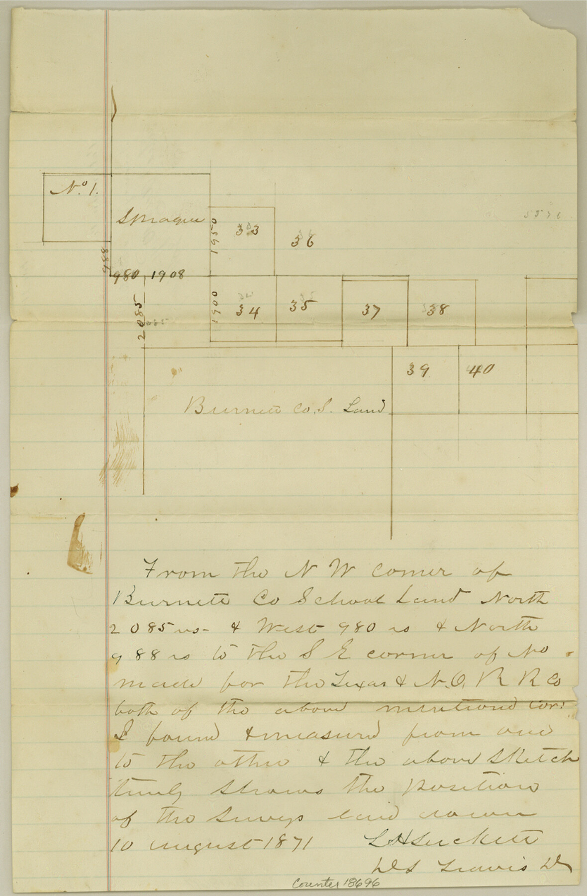
[Sketch of surveys around Burnet County School Land]
-
Map/Doc
18696
-
Collection
General Map Collection
-
Object Dates
1871/8/10 (Creation Date)
1871/8/10 (File Date)
-
People and Organizations
L.H. Luckett (Surveyor/Engineer)
-
Counties
Coleman
-
Subjects
Surveying Sketch File
-
Height x Width
12.7 x 8.3 inches
32.3 x 21.1 cm
-
Medium
paper, manuscript
Part of: General Map Collection
Polk County Working Sketch 21

Print $20.00
- Digital $50.00
Polk County Working Sketch 21
1953
Size 22.6 x 24.2 inches
Map/Doc 71636
Hardin County Sketch File 68

Print $20.00
- Digital $50.00
Hardin County Sketch File 68
1948
Size 23.9 x 21.4 inches
Map/Doc 11640
Midland County Rolled Sketch 6

Print $20.00
- Digital $50.00
Midland County Rolled Sketch 6
1951
Size 39.8 x 28.6 inches
Map/Doc 6764
Yoakum County Sketch File 15

Print $22.00
- Digital $50.00
Yoakum County Sketch File 15
1938
Size 18.0 x 8.8 inches
Map/Doc 40793
Flight Mission No. DAG-23K, Frame 15, Matagorda County

Print $20.00
- Digital $50.00
Flight Mission No. DAG-23K, Frame 15, Matagorda County
1953
Size 15.5 x 15.3 inches
Map/Doc 86477
Presidio County Sketch File 81

Print $20.00
- Digital $50.00
Presidio County Sketch File 81
1949
Size 47.2 x 21.6 inches
Map/Doc 10579
Crockett County Sketch File 13

Print $22.00
- Digital $50.00
Crockett County Sketch File 13
Size 8.9 x 3.6 inches
Map/Doc 19665
Matagorda County Sketch File 34

Print $6.00
- Digital $50.00
Matagorda County Sketch File 34
1950
Size 14.3 x 8.8 inches
Map/Doc 30820
Gregg County Rolled Sketch 8

Print $40.00
- Digital $50.00
Gregg County Rolled Sketch 8
1933
Size 26.3 x 50.9 inches
Map/Doc 9027
Bee County Working Sketch 16

Print $20.00
- Digital $50.00
Bee County Working Sketch 16
1974
Size 18.0 x 19.6 inches
Map/Doc 67266
Wharton County Working Sketch 14

Print $20.00
- Digital $50.00
Wharton County Working Sketch 14
1961
Size 26.5 x 24.9 inches
Map/Doc 72478
Flight Mission No. DQN-1K, Frame 102, Calhoun County

Print $20.00
- Digital $50.00
Flight Mission No. DQN-1K, Frame 102, Calhoun County
1953
Size 17.7 x 22.1 inches
Map/Doc 84169
You may also like
Shelby County Sketch File 34

Print $3.00
- Digital $50.00
Shelby County Sketch File 34
1847
Size 10.1 x 15.7 inches
Map/Doc 36674
Cass County Working Sketch 11

Print $3.00
- Digital $50.00
Cass County Working Sketch 11
Size 14.8 x 10.3 inches
Map/Doc 67914
Flight Mission No. DIX-5P, Frame 111, Aransas County

Print $20.00
- Digital $50.00
Flight Mission No. DIX-5P, Frame 111, Aransas County
1956
Size 17.6 x 18.0 inches
Map/Doc 83790
Callahan County Boundary File 1a

Print $4.00
- Digital $50.00
Callahan County Boundary File 1a
Size 13.3 x 8.7 inches
Map/Doc 51085
Pecos County Working Sketch 37

Print $20.00
- Digital $50.00
Pecos County Working Sketch 37
1939
Size 30.0 x 43.0 inches
Map/Doc 71509
Jackson County Sketch File 10x

Print $40.00
- Digital $50.00
Jackson County Sketch File 10x
1914
Size 13.8 x 12.0 inches
Map/Doc 27656
Loving County Working Sketch 12

Print $40.00
- Digital $50.00
Loving County Working Sketch 12
1957
Size 48.1 x 37.1 inches
Map/Doc 70645
North end of Brazos Island

Print $20.00
- Digital $50.00
North end of Brazos Island
Size 26.0 x 18.3 inches
Map/Doc 72915
Lamar County Sketch File 10

Print $4.00
- Digital $50.00
Lamar County Sketch File 10
1872
Size 8.1 x 9.9 inches
Map/Doc 29293
Irion County Rolled Sketch 18B

Print $152.00
- Digital $50.00
Irion County Rolled Sketch 18B
1978
Size 10.6 x 15.2 inches
Map/Doc 46087
Navarro County Sketch File 3

Print $8.00
- Digital $50.00
Navarro County Sketch File 3
1847
Size 10.2 x 8.1 inches
Map/Doc 32300
Lampasas County Working Sketch 10

Print $20.00
- Digital $50.00
Lampasas County Working Sketch 10
1963
Size 32.2 x 42.9 inches
Map/Doc 70287