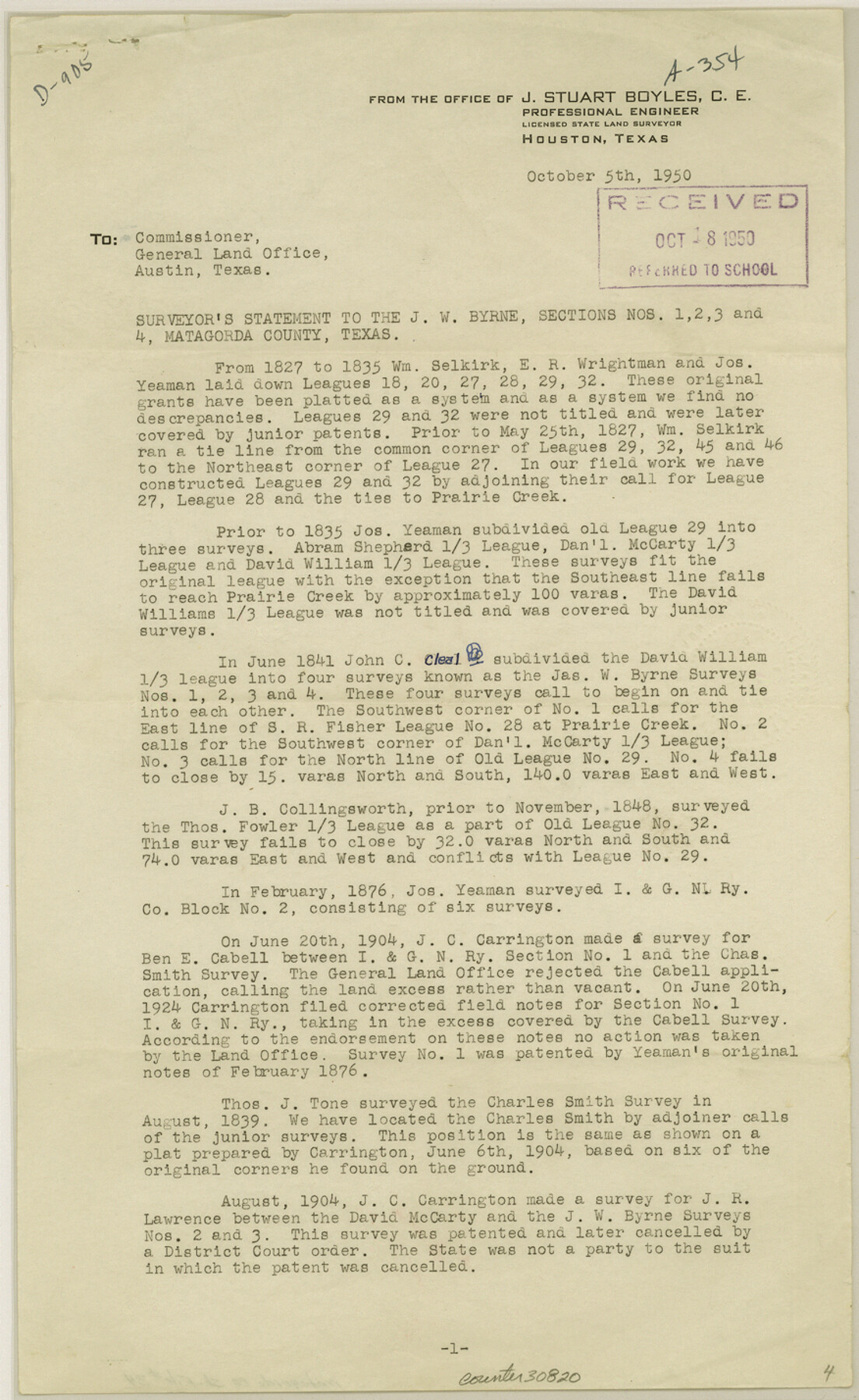
Matagorda County Sketch File 34
[Surveyors report of resurvey of J. W. Byrne surveys No. 1, 2, 3 and 4]
-
Map/Doc
30820
-
Collection
General Map Collection
-
Object Dates
9/1950 (Creation Date)
10/18/1950 (File Date)
-
People and Organizations
J.S. Boyles (Surveyor/Engineer)
-
Counties
Matagorda
-
Subjects
Surveying Sketch File
-
Height x Width
14.3 x 8.8 inches
36.3 x 22.4 cm
-
Medium
paper, print
-
Comments
See Matagorda County Rolled Sketch 26 (9479) for sketch.
-
Features
Prairie Creek
Payton's Creek
Related maps
Matagorda County Rolled Sketch 26

Print $20.00
- Digital $50.00
Matagorda County Rolled Sketch 26
1950
Size 39.5 x 42.1 inches
Map/Doc 9479
Part of: General Map Collection
Dimmit County Sketch File 2

Print $6.00
- Digital $50.00
Dimmit County Sketch File 2
Size 8.6 x 7.9 inches
Map/Doc 21055
Parker County Working Sketch 6

Print $20.00
- Digital $50.00
Parker County Working Sketch 6
1923
Map/Doc 71456
Webb County Sketch File 8c

Print $4.00
- Digital $50.00
Webb County Sketch File 8c
1877
Size 12.7 x 8.2 inches
Map/Doc 39759
Pecos County Working Sketch 12

Print $20.00
- Digital $50.00
Pecos County Working Sketch 12
1912
Size 21.3 x 30.0 inches
Map/Doc 71482
Atascosa County Rolled Sketch 4

Print $20.00
- Digital $50.00
Atascosa County Rolled Sketch 4
Size 21.0 x 15.8 inches
Map/Doc 5087
San Patricio County Working Sketch 1

Print $20.00
- Digital $50.00
San Patricio County Working Sketch 1
Size 25.2 x 26.2 inches
Map/Doc 63763
Montgomery County Working Sketch 1

Print $20.00
- Digital $50.00
Montgomery County Working Sketch 1
1912
Size 20.8 x 17.1 inches
Map/Doc 71107
Flight Mission No. DQN-2K, Frame 30, Calhoun County

Print $20.00
- Digital $50.00
Flight Mission No. DQN-2K, Frame 30, Calhoun County
1953
Size 18.5 x 22.2 inches
Map/Doc 84237
Map of Eastland County

Print $20.00
- Digital $50.00
Map of Eastland County
1889
Size 22.9 x 21.2 inches
Map/Doc 3502
Young County Sketch File 13

Print $4.00
- Digital $50.00
Young County Sketch File 13
1891
Size 8.3 x 10.0 inches
Map/Doc 40878
Flight Mission No. DAH-9M, Frame 86, Orange County

Print $20.00
- Digital $50.00
Flight Mission No. DAH-9M, Frame 86, Orange County
1953
Size 18.4 x 22.2 inches
Map/Doc 86850
Starr County Sketch File 35

Print $24.00
- Digital $50.00
Starr County Sketch File 35
1939
Size 14.3 x 8.8 inches
Map/Doc 36974
You may also like
Robertson V Ranch

Print $20.00
- Digital $50.00
Robertson V Ranch
Size 41.7 x 46.0 inches
Map/Doc 89756
Newton County Working Sketch 26

Print $20.00
- Digital $50.00
Newton County Working Sketch 26
1953
Size 18.3 x 16.4 inches
Map/Doc 71272
Galveston County Rolled Sketch 22

Print $20.00
- Digital $50.00
Galveston County Rolled Sketch 22
1953
Size 28.8 x 39.5 inches
Map/Doc 9663
[Sketch showing counties along Texas-New Mexico border]
![91986, [Sketch showing counties along Texas-New Mexico border], Twichell Survey Records](https://historictexasmaps.com/wmedia_w700/maps/91986-1.tif.jpg)
Print $3.00
- Digital $50.00
[Sketch showing counties along Texas-New Mexico border]
Size 11.0 x 16.7 inches
Map/Doc 91986
[Galveston, Harrisburg & San Antonio Railroad from Cuero to Stockdale]
![64203, [Galveston, Harrisburg & San Antonio Railroad from Cuero to Stockdale], General Map Collection](https://historictexasmaps.com/wmedia_w700/maps/64203.tif.jpg)
Print $20.00
- Digital $50.00
[Galveston, Harrisburg & San Antonio Railroad from Cuero to Stockdale]
1907
Size 13.2 x 33.1 inches
Map/Doc 64203
Sabine County Working Sketch 1

Print $20.00
- Digital $50.00
Sabine County Working Sketch 1
1922
Size 17.7 x 17.7 inches
Map/Doc 63672

Glasscock County Working Sketch 16

Print $40.00
- Digital $50.00
Glasscock County Working Sketch 16
1984
Size 61.2 x 44.0 inches
Map/Doc 63189
Erath County Working Sketch 8

Print $20.00
- Digital $50.00
Erath County Working Sketch 8
1936
Size 16.0 x 16.2 inches
Map/Doc 69089
Cooke County Sketch File 3

Print $2.00
- Digital $50.00
Cooke County Sketch File 3
1873
Size 6.3 x 7.7 inches
Map/Doc 19222
Webb County Sketch File 1-2

Print $20.00
- Digital $50.00
Webb County Sketch File 1-2
1912
Size 21.2 x 22.6 inches
Map/Doc 12611
Duval County Sketch File 20

Print $20.00
- Digital $50.00
Duval County Sketch File 20
1880
Size 17.9 x 14.6 inches
Map/Doc 11384