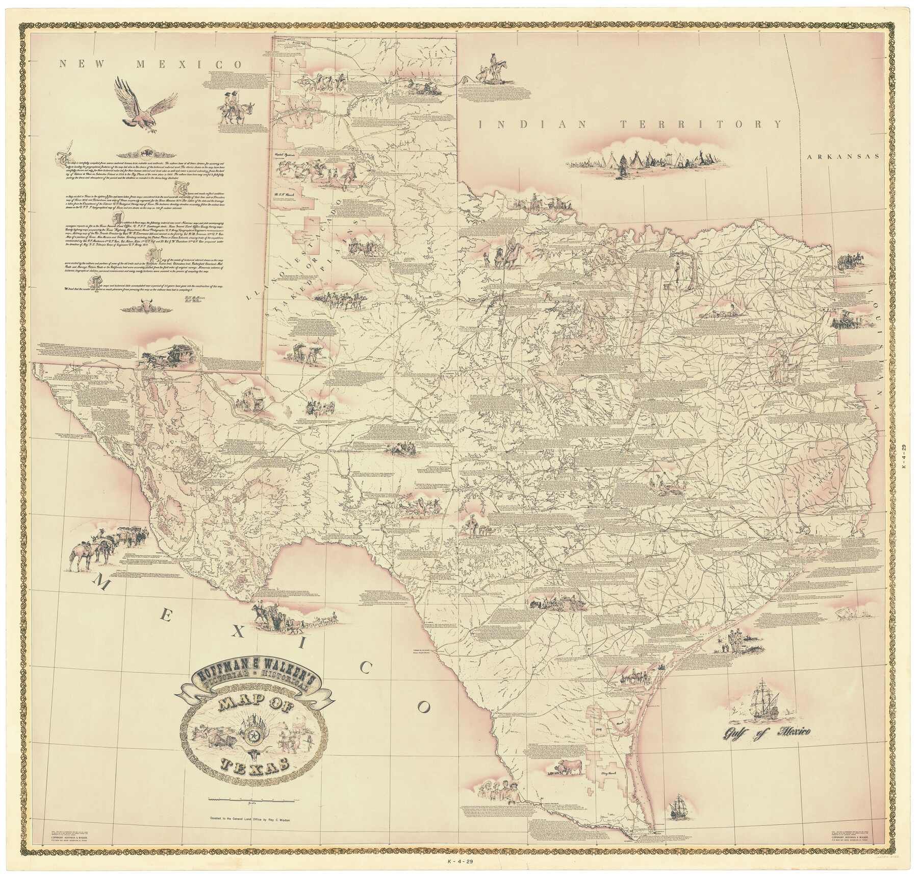
Hoffman and Walker's Pictorial, Historical Map of Texas
K-4-29
-
Map/Doc
2122
-
Collection
General Map Collection
-
Object Dates
1960 - 1969 (Creation Date)
-
People and Organizations
Hoffman and Walker (Author)
-
Subjects
Pictorial State of Texas
-
Height x Width
44.0 x 45.5 inches
111.8 x 115.6 cm
-
Comments
Map presented to Col. George I. Taylor, as a gift in 1966 when he was Chief of Staff of the 1st Armored Division while serving at Ft. Hood, Texas.
Donated to the GLO by his children in his honor.
Pictorial and historical. Available for research only--copyrighted and unavailable for duplication. -
URLs
https://medium.com/save-texas-history/illustrated-cartography-pictorial-maps-at-the-glo-hoffman-and-walkers-historical-pictorial-map-55c31eed7cf2#.el8rqclef
Part of: General Map Collection
Houston County Sketch File 2

Print $4.00
- Digital $50.00
Houston County Sketch File 2
1857
Size 12.6 x 7.9 inches
Map/Doc 26746
Hamilton County Boundary File 6

Print $4.00
- Digital $50.00
Hamilton County Boundary File 6
Size 11.2 x 8.6 inches
Map/Doc 54225
Pecos County Rolled Sketch 155

Print $40.00
- Digital $50.00
Pecos County Rolled Sketch 155
Size 65.1 x 44.8 inches
Map/Doc 9737
Coleman County Sketch File 3a

Print $20.00
- Digital $50.00
Coleman County Sketch File 3a
1857
Size 12.6 x 19.2 inches
Map/Doc 11117
[Sketch for Mineral Application 13440]
![65673, [Sketch for Mineral Application 13440], General Map Collection](https://historictexasmaps.com/wmedia_w700/maps/65673.tif.jpg)
Print $40.00
- Digital $50.00
[Sketch for Mineral Application 13440]
Size 42.4 x 66.0 inches
Map/Doc 65673
Freestone County State of Texas

Print $20.00
- Digital $50.00
Freestone County State of Texas
1888
Size 27.2 x 21.6 inches
Map/Doc 3562
Brewster County Rolled Sketch 138

Print $20.00
- Digital $50.00
Brewster County Rolled Sketch 138
1982
Size 24.5 x 38.0 inches
Map/Doc 5306
Flight Mission No. DQN-1K, Frame 28, Calhoun County

Print $20.00
- Digital $50.00
Flight Mission No. DQN-1K, Frame 28, Calhoun County
1953
Size 18.5 x 22.3 inches
Map/Doc 84133
Wilson County Rolled Sketch 4

Print $20.00
- Digital $50.00
Wilson County Rolled Sketch 4
Size 27.1 x 29.6 inches
Map/Doc 8370
San Patricio County Working Sketch 15

Print $4.00
- Digital $50.00
San Patricio County Working Sketch 15
Size 20.9 x 25.6 inches
Map/Doc 63777
Bastrop County Working Sketch 16

Print $20.00
- Digital $50.00
Bastrop County Working Sketch 16
1998
Size 39.2 x 34.1 inches
Map/Doc 67316
Sketch showing the progress of the survey in Sections 8 & 9 from 1846 to 1882

Print $20.00
- Digital $50.00
Sketch showing the progress of the survey in Sections 8 & 9 from 1846 to 1882
Size 21.8 x 37.2 inches
Map/Doc 96560
You may also like
Map of Survey in Dimmit and Webb Counties

Print $40.00
- Digital $50.00
Map of Survey in Dimmit and Webb Counties
1913
Size 31.3 x 71.0 inches
Map/Doc 75829
Bandera County Working Sketch 57

Print $20.00
- Digital $50.00
Bandera County Working Sketch 57
1991
Size 38.5 x 46.8 inches
Map/Doc 67653
Bosque County Sketch File 21

Print $12.00
- Digital $50.00
Bosque County Sketch File 21
1863
Size 10.9 x 8.7 inches
Map/Doc 14798
Flight Mission No. CGI-4N, Frame 174, Cameron County

Print $20.00
- Digital $50.00
Flight Mission No. CGI-4N, Frame 174, Cameron County
1955
Size 18.7 x 22.3 inches
Map/Doc 84677
Moore County Rolled Sketch 16A

Print $20.00
- Digital $50.00
Moore County Rolled Sketch 16A
1982
Size 21.1 x 33.4 inches
Map/Doc 6834
Nora Subdivision in NE 1/4 Section 8, Block B

Print $20.00
- Digital $50.00
Nora Subdivision in NE 1/4 Section 8, Block B
1950
Size 12.2 x 18.0 inches
Map/Doc 92309
Dimmit County Rolled Sketch 21

Print $20.00
- Digital $50.00
Dimmit County Rolled Sketch 21
2013
Size 25.5 x 22.5 inches
Map/Doc 93488
[Pencil Sketch of a portion of Block D-8]
![91872, [Pencil Sketch of a portion of Block D-8], Twichell Survey Records](https://historictexasmaps.com/wmedia_w700/maps/91872-1.tif.jpg)
Print $2.00
- Digital $50.00
[Pencil Sketch of a portion of Block D-8]
1937
Size 14.5 x 9.1 inches
Map/Doc 91872
Erath County Working Sketch 43

Print $4.00
- Digital $50.00
Erath County Working Sketch 43
Size 19.6 x 15.7 inches
Map/Doc 69124
Pecos County Rolled Sketch 158

Print $20.00
- Digital $50.00
Pecos County Rolled Sketch 158
1961
Size 21.9 x 27.4 inches
Map/Doc 7284
[Rand McNally's Indexed Map of Texas and Indian Territory]
![93992, [Rand McNally's Indexed Map of Texas and Indian Territory], Rees-Jones Digital Map Collection](https://historictexasmaps.com/wmedia_w700/maps/93992.tif.jpg)
Print $20.00
- Digital $50.00
[Rand McNally's Indexed Map of Texas and Indian Territory]
Size 26.0 x 20.6 inches
Map/Doc 93992
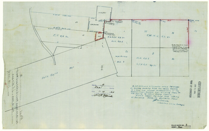
Real County Rolled Sketch 3
Print $20.00
- Digital $50.00
Real County Rolled Sketch 3
1955
Size 14.6 x 23.3 inches
Map/Doc 7453