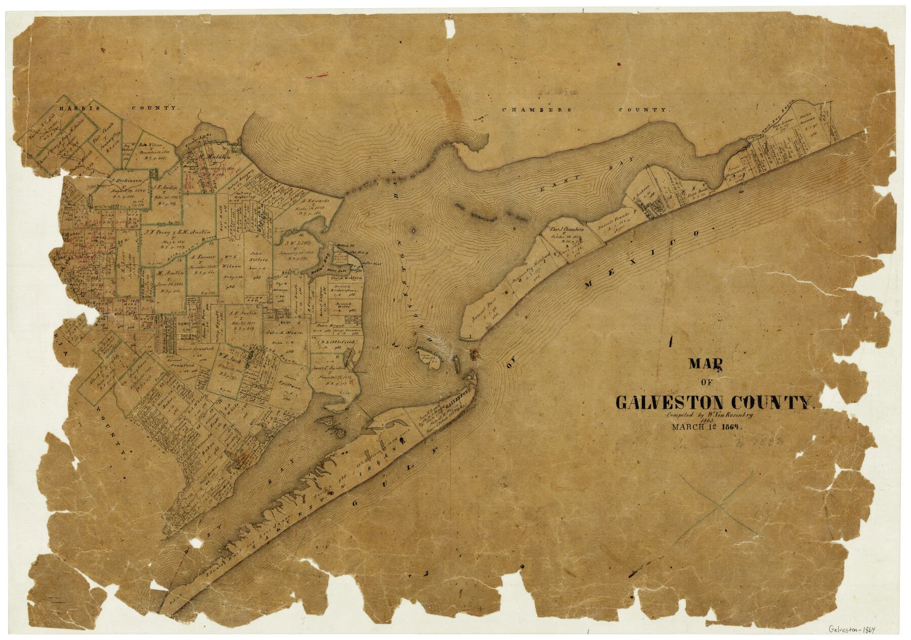
Map of Galveston County
-
Map/Doc
3576
-
Collection
General Map Collection
-
Object Dates
1864/3/1 (Creation Date)
-
People and Organizations
Texas General Land Office (Publisher)
W. von Rosenberg (Compiler)
-
Counties
Galveston
-
Subjects
County
-
Height x Width
19.6 x 28.0 inches
49.8 x 71.1 cm
-
Comments
Compiled in 1863; in use to 1883.
-
Features
Virginia Point
Highland Bayou
Basford Bayou
Swan Lake
Camel's House
Pelican Island
Pelican Spit
Boliver Point
Fort Reserve
Dickinson's Creek
North Deer Island
South Deer Island
Middle Deer Island
Hall's Bayou
Galveston
Galveston Island
Bolivar Lighthouse
Coward's Bayou
Galveston Bay
West Bay
Gulf of Mexico
Clear Lake
Clear Creek
Jarboe Creek
Chigoe Bayou
Mary's Bayou
East Bay
East Bay Bayou
Bolivar Peninsula
Dollar Bay
Moses Lake
Dollar Point
Miller's Point
Moses Bayou
Part of: General Map Collection
Van Zandt County Sketch File 21

Print $4.00
- Digital $50.00
Van Zandt County Sketch File 21
1858
Size 12.1 x 7.7 inches
Map/Doc 39430
Fort Bend County Sketch File 9a

Print $15.00
- Digital $50.00
Fort Bend County Sketch File 9a
Size 14.6 x 8.9 inches
Map/Doc 22897
Menard County Sketch File 19

Print $4.00
- Digital $50.00
Menard County Sketch File 19
1905
Size 11.2 x 8.8 inches
Map/Doc 31546
Crockett County Working Sketch 4

Print $40.00
- Digital $50.00
Crockett County Working Sketch 4
Size 26.8 x 70.4 inches
Map/Doc 68337
Nueces County Rolled Sketch 91

Print $79.00
Nueces County Rolled Sketch 91
1983
Size 24.6 x 37.2 inches
Map/Doc 7017
Starr County Sketch File 25

Print $42.00
- Digital $50.00
Starr County Sketch File 25
1921
Size 9.1 x 8.6 inches
Map/Doc 36927
Flight Mission No. DAG-23K, Frame 15, Matagorda County

Print $20.00
- Digital $50.00
Flight Mission No. DAG-23K, Frame 15, Matagorda County
1953
Size 15.5 x 15.3 inches
Map/Doc 86477
Jeff Davis County Sketch File 46

Print $8.00
- Digital $50.00
Jeff Davis County Sketch File 46
1906
Size 13.5 x 8.8 inches
Map/Doc 28080
Cottle County Sketch File 3a

Print $14.00
- Digital $50.00
Cottle County Sketch File 3a
Size 12.9 x 8.8 inches
Map/Doc 19459
A New Map of North America with the West India Islands divided according to the preliminary Articles of Peace, signed at Versailles, 20 Jan. 1783

Print $40.00
- Digital $50.00
A New Map of North America with the West India Islands divided according to the preliminary Articles of Peace, signed at Versailles, 20 Jan. 1783
1794
Size 42.1 x 48.4 inches
Map/Doc 93734
Maverick County Sketch File 9

Print $8.00
- Digital $50.00
Maverick County Sketch File 9
1878
Size 5.3 x 5.6 inches
Map/Doc 31068
Galveston County NRC Article 33.136 Sketch 97

Print $414.00
Galveston County NRC Article 33.136 Sketch 97
2024
Map/Doc 97407
You may also like
Flight Mission No. BQR-13K, Frame 121, Brazoria County

Print $20.00
- Digital $50.00
Flight Mission No. BQR-13K, Frame 121, Brazoria County
1952
Size 18.6 x 22.3 inches
Map/Doc 84082
Flight Mission No. DQO-1K, Frame 145, Galveston County

Print $20.00
- Digital $50.00
Flight Mission No. DQO-1K, Frame 145, Galveston County
1952
Size 18.9 x 22.6 inches
Map/Doc 84998
Millennium in Maps - Exploration

Millennium in Maps - Exploration
Size 20.6 x 31.5 inches
Map/Doc 95931
General Highway Map, Gaines County, Texas

Print $20.00
- Digital $50.00
General Highway Map, Gaines County, Texas
1951
Size 18.8 x 25.9 inches
Map/Doc 92639
Coke County Rolled Sketch 12A

Print $20.00
- Digital $50.00
Coke County Rolled Sketch 12A
1949
Size 21.1 x 23.4 inches
Map/Doc 5513
Chambers County Rolled Sketch 24

Print $40.00
- Digital $50.00
Chambers County Rolled Sketch 24
1940
Size 38.2 x 49.9 inches
Map/Doc 8594
Aransas County Sketch File 28

Print $16.00
- Digital $50.00
Aransas County Sketch File 28
1973
Size 11.3 x 8.8 inches
Map/Doc 13226
Eastland County Working Sketch 45

Print $20.00
- Digital $50.00
Eastland County Working Sketch 45
1979
Size 31.3 x 43.7 inches
Map/Doc 68826
Flight Mission No. CRK-5P, Frame 161, Refugio County

Print $20.00
- Digital $50.00
Flight Mission No. CRK-5P, Frame 161, Refugio County
1956
Size 18.5 x 22.4 inches
Map/Doc 86942
Flight Mission No. DCL-7C, Frame 73, Kenedy County

Print $20.00
- Digital $50.00
Flight Mission No. DCL-7C, Frame 73, Kenedy County
1943
Size 15.6 x 15.3 inches
Map/Doc 86059
Reagan County Rolled Sketch 27

Print $40.00
- Digital $50.00
Reagan County Rolled Sketch 27
Size 66.0 x 47.2 inches
Map/Doc 9821
Red River County Sketch File 3

Print $4.00
- Digital $50.00
Red River County Sketch File 3
Size 10.4 x 8.3 inches
Map/Doc 35098