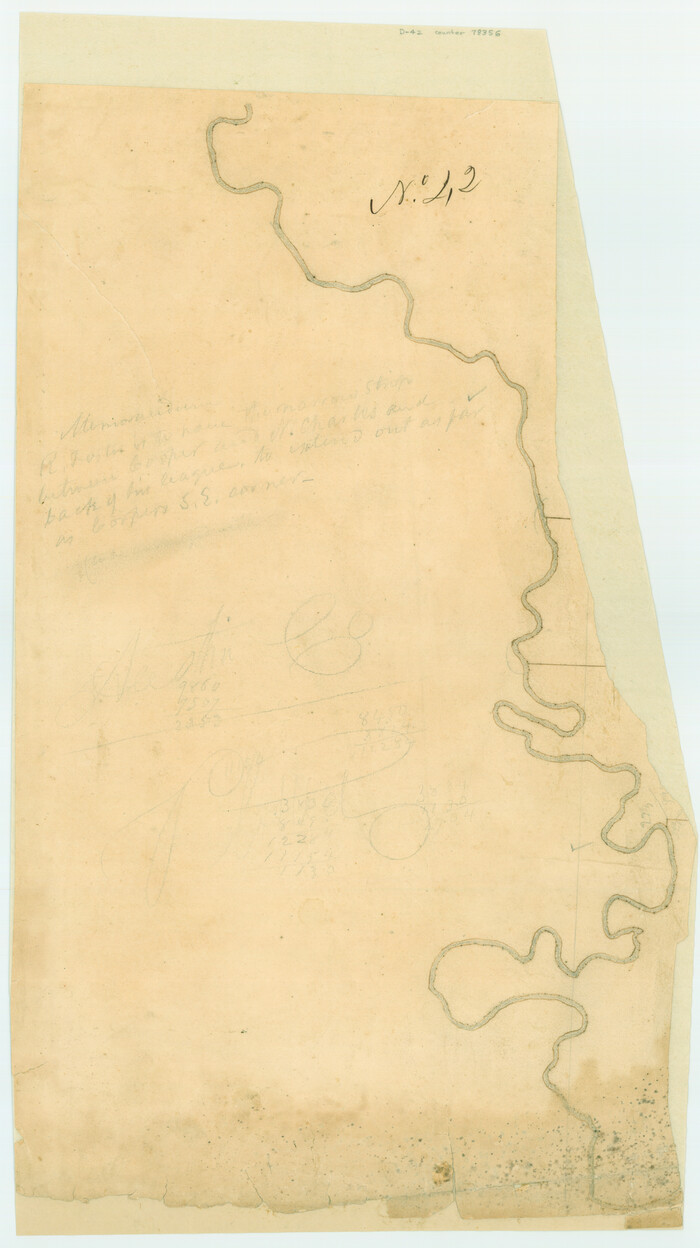
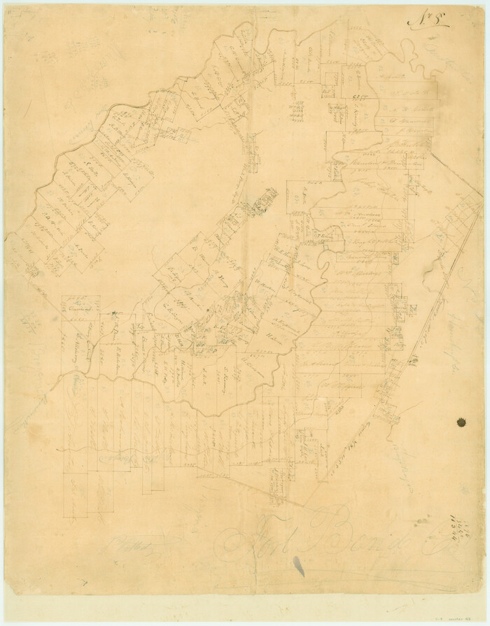
[Surveys possibly in Austin County]
Print $3.00
- Digital $50.00
[Surveys possibly in Austin County]
Size: 17.0 x 9.6 inches
78356
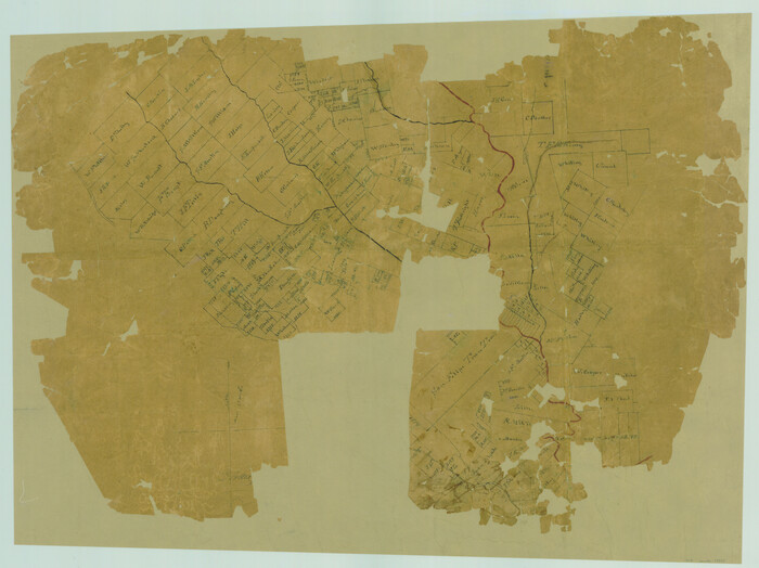
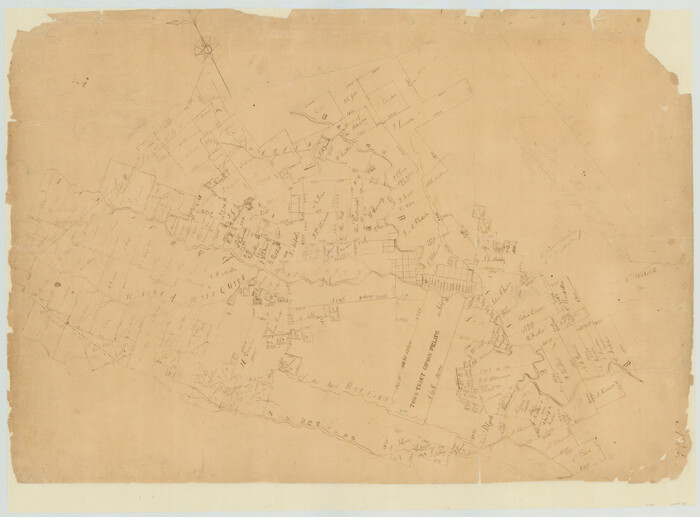
[Surveys in Waller County]
Print $20.00
- Digital $50.00
[Surveys in Waller County]
Size: 21.5 x 28.7 inches
78367
[Surveys in Austin's Colony by Horatio Chriesman along Mill and Cummins Creeks]
Print $20.00
- Digital $50.00
[Surveys in Austin's Colony by Horatio Chriesman along Mill and Cummins Creeks]
1830
Size: 30.7 x 25.7 inches
68
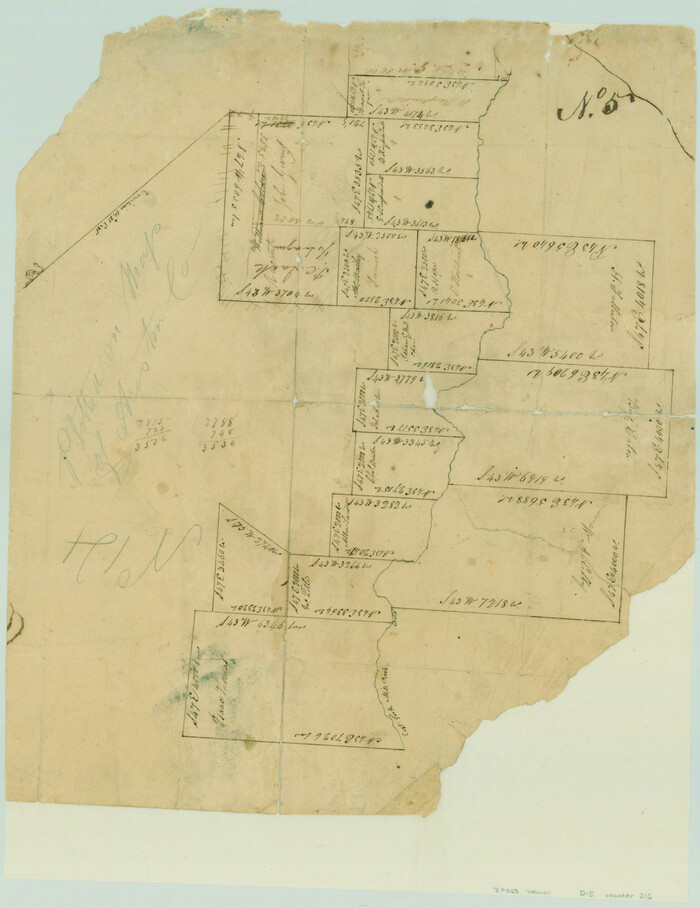
[Surveys in Austin's Colony along the east bank of Mill Creek]
Print $3.00
- Digital $50.00
[Surveys in Austin's Colony along the east bank of Mill Creek]
1827
Size: 14.4 x 11.1 inches
216
[Surveys in Austin's Colony along the Brazos and Bernard Rivers]
Print $20.00
- Digital $50.00
[Surveys in Austin's Colony along the Brazos and Bernard Rivers]
1835
Size: 23.8 x 18.6 inches
43
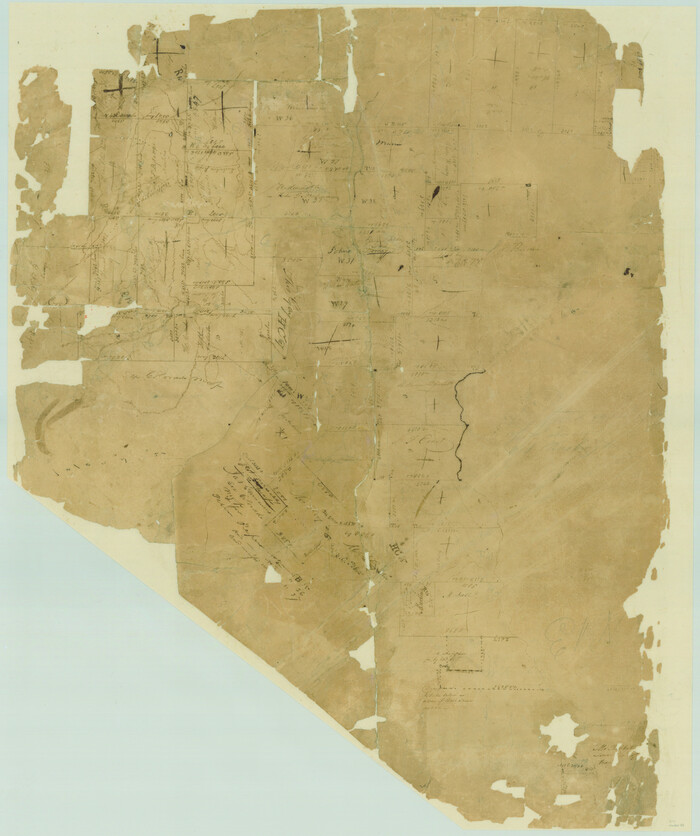
[Surveys in Austin County]
Print $20.00
- Digital $50.00
[Surveys in Austin County]
1840
Size: 20.8 x 28.2 inches
35
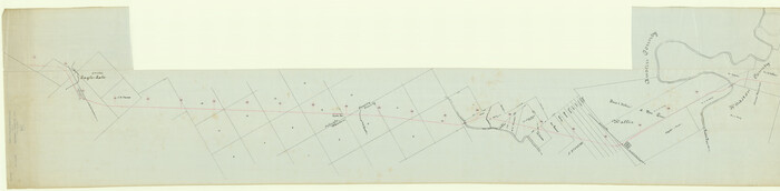
[San Antonio & Aransas Pass R.R. Right of Way from Eagle Lake to Brazos River]
Print $40.00
- Digital $50.00
[San Antonio & Aransas Pass R.R. Right of Way from Eagle Lake to Brazos River]
1895
Size: 30.8 x 124.9 inches
64256
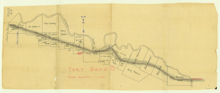
[Gulf, Colorado & Santa Fe Railway line through Fort Bend Co.]
Print $20.00
- Digital $50.00
[Gulf, Colorado & Santa Fe Railway line through Fort Bend Co.]
1898
Size: 14.2 x 33.5 inches
64212
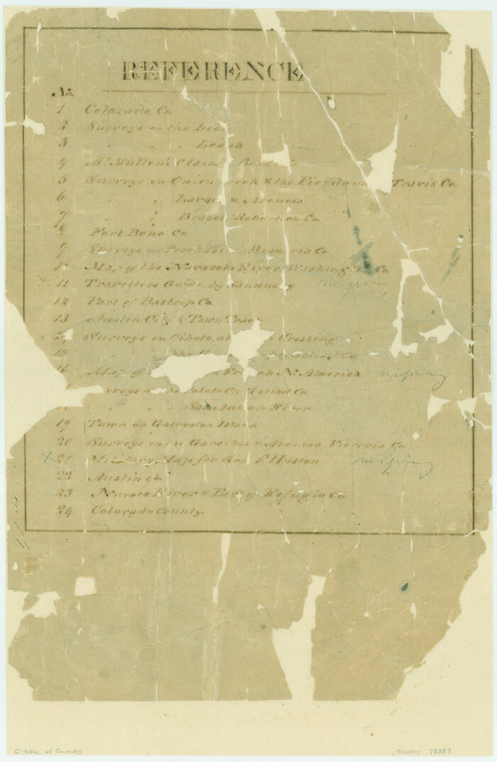
[Atlas C, Table of Contents]
Print $3.00
- Digital $50.00
[Atlas C, Table of Contents]
Size: 14.7 x 9.6 inches
78353
Water-Shed of the Brazos River

Print $40.00
- Digital $50.00
Water-Shed of the Brazos River
1925
Size: 35.0 x 88.0 inches
65263
Washington County Sketch File 3

Print $4.00
- Digital $50.00
Washington County Sketch File 3
1860
Size: 8.1 x 9.2 inches
39648
Washington County Sketch File 2

Print $4.00
- Digital $50.00
Washington County Sketch File 2
1855
Size: 8.3 x 12.5 inches
39646
The Republic County of Austin. Proposed, Late Fall 1837

Print $20.00
The Republic County of Austin. Proposed, Late Fall 1837
2020
Size: 14.8 x 21.7 inches
96080
The Republic County of Austin. Proposed, Fall 1837-May 23, 1838

Print $20.00
The Republic County of Austin. Proposed, Fall 1837-May 23, 1838
2020
Size: 14.8 x 21.7 inches
96081
The Republic County of Austin. January 29, 1842

Print $20.00
The Republic County of Austin. January 29, 1842
2020
Size: 14.7 x 21.7 inches
96086
The Republic County of Austin. January 28, 1841

Print $20.00
The Republic County of Austin. January 28, 1841
2020
Size: 14.7 x 21.7 inches
96085
The Republic County of Austin. January 10, 1839

Print $20.00
The Republic County of Austin. January 10, 1839
2020
Size: 7.0 x 22.0 inches
96083
The Republic County of Austin. February 5, 1840

Print $20.00
The Republic County of Austin. February 5, 1840
2020
Size: 14.7 x 21.7 inches
96084
The Republic County of Austin. February 1, 1844

Print $20.00
The Republic County of Austin. February 1, 1844
2020
Size: 14.7 x 21.7 inches
96087
The Republic County of Austin. Defined, May 24, 1838

Print $20.00
The Republic County of Austin. Defined, May 24, 1838
2020
Size: 14.7 x 21.6 inches
96082
The Republic County of Austin. December 29, 1845

Print $20.00
The Republic County of Austin. December 29, 1845
2020
Size: 14.7 x 21.6 inches
96088
Surveys in Austin's Colony along the east fork of Mill Creek

Print $20.00
- Digital $50.00
Surveys in Austin's Colony along the east fork of Mill Creek
1830
Size: 23.7 x 12.6 inches
208
Stephen F. Austin Park

Print $20.00
- Digital $50.00
Stephen F. Austin Park
1950
Size: 24.7 x 36.9 inches
73568
San Felipe Town Tract & Adjoining Survey for S. F. Austin and A. Lester

Print $2.00
- Digital $50.00
San Felipe Town Tract & Adjoining Survey for S. F. Austin and A. Lester
Size: 9.9 x 8.1 inches
78368
Plot of land tracts situated in Austin Co. west of Mill Creek opposite and above the fork of the same

Print $2.00
- Digital $50.00
Plot of land tracts situated in Austin Co. west of Mill Creek opposite and above the fork of the same
1845
Size: 7.7 x 8.1 inches
224
Plan of the town of Austin

Print $20.00
- Digital $50.00
Plan of the town of Austin
Size: 18.4 x 13.0 inches
94117
Plan de la Villa de Austin

Print $20.00
- Digital $50.00
Plan de la Villa de Austin
1828
Size: 18.5 x 12.5 inches
94116
Map of the 1st, 2nd and 3rd Sections of Houston & Texas Central Railroad

Print $40.00
- Digital $50.00
Map of the 1st, 2nd and 3rd Sections of Houston & Texas Central Railroad
Size: 30.7 x 64.6 inches
64478
Map of Taylor, Bastrop & Houston Railway through Colorado County, Texas

Print $20.00
- Digital $50.00
Map of Taylor, Bastrop & Houston Railway through Colorado County, Texas
1888
Size: 12.7 x 20.0 inches
64289
Map of Taylor, Bastrop & Houston Railroad in Austin County

Print $20.00
- Digital $50.00
Map of Taylor, Bastrop & Houston Railroad in Austin County
Size: 14.6 x 25.1 inches
64480
[Surveys possibly in Austin County]
Print $3.00
- Digital $50.00
[Surveys possibly in Austin County]
-
Size
17.0 x 9.6 inches
-
Map/Doc
78356
[Surveys in Waller County]
Print $20.00
- Digital $50.00
[Surveys in Waller County]
-
Size
21.5 x 28.7 inches
-
Map/Doc
78367
[Surveys in Austin's Colony by Horatio Chriesman along Mill and Cummins Creeks]
Print $20.00
- Digital $50.00
[Surveys in Austin's Colony by Horatio Chriesman along Mill and Cummins Creeks]
1830
-
Size
30.7 x 25.7 inches
-
Map/Doc
68
-
Creation Date
1830
[Surveys in Austin's Colony along the east bank of Mill Creek]
Print $3.00
- Digital $50.00
[Surveys in Austin's Colony along the east bank of Mill Creek]
1827
-
Size
14.4 x 11.1 inches
-
Map/Doc
216
-
Creation Date
1827
[Surveys in Austin's Colony along the Brazos and Bernard Rivers]
Print $20.00
- Digital $50.00
[Surveys in Austin's Colony along the Brazos and Bernard Rivers]
1835
-
Size
23.8 x 18.6 inches
-
Map/Doc
43
-
Creation Date
1835
[Surveys in Austin County]
Print $20.00
- Digital $50.00
[Surveys in Austin County]
1840
-
Size
20.8 x 28.2 inches
-
Map/Doc
35
-
Creation Date
1840
[San Antonio & Aransas Pass R.R. Right of Way from Eagle Lake to Brazos River]
Print $40.00
- Digital $50.00
[San Antonio & Aransas Pass R.R. Right of Way from Eagle Lake to Brazos River]
1895
-
Size
30.8 x 124.9 inches
-
Map/Doc
64256
-
Creation Date
1895
[Gulf, Colorado & Santa Fe Railway line through Fort Bend Co.]
Print $20.00
- Digital $50.00
[Gulf, Colorado & Santa Fe Railway line through Fort Bend Co.]
1898
-
Size
14.2 x 33.5 inches
-
Map/Doc
64212
-
Creation Date
1898
[Atlas C, Table of Contents]
Print $3.00
- Digital $50.00
[Atlas C, Table of Contents]
-
Size
14.7 x 9.6 inches
-
Map/Doc
78353
Water-Shed of the Brazos River
Print $40.00
- Digital $50.00
Water-Shed of the Brazos River
1925
-
Size
35.0 x 88.0 inches
-
Map/Doc
65263
-
Creation Date
1925
Washington County Sketch File 3
Print $4.00
- Digital $50.00
Washington County Sketch File 3
1860
-
Size
8.1 x 9.2 inches
-
Map/Doc
39648
-
Creation Date
1860
Washington County Sketch File 2
Print $4.00
- Digital $50.00
Washington County Sketch File 2
1855
-
Size
8.3 x 12.5 inches
-
Map/Doc
39646
-
Creation Date
1855
The Republic County of Austin. Proposed, Late Fall 1837
Print $20.00
The Republic County of Austin. Proposed, Late Fall 1837
2020
-
Size
14.8 x 21.7 inches
-
Map/Doc
96080
-
Creation Date
2020
The Republic County of Austin. Proposed, Fall 1837-May 23, 1838
Print $20.00
The Republic County of Austin. Proposed, Fall 1837-May 23, 1838
2020
-
Size
14.8 x 21.7 inches
-
Map/Doc
96081
-
Creation Date
2020
The Republic County of Austin. January 29, 1842
Print $20.00
The Republic County of Austin. January 29, 1842
2020
-
Size
14.7 x 21.7 inches
-
Map/Doc
96086
-
Creation Date
2020
The Republic County of Austin. January 28, 1841
Print $20.00
The Republic County of Austin. January 28, 1841
2020
-
Size
14.7 x 21.7 inches
-
Map/Doc
96085
-
Creation Date
2020
The Republic County of Austin. January 10, 1839
Print $20.00
The Republic County of Austin. January 10, 1839
2020
-
Size
7.0 x 22.0 inches
-
Map/Doc
96083
-
Creation Date
2020
The Republic County of Austin. February 5, 1840
Print $20.00
The Republic County of Austin. February 5, 1840
2020
-
Size
14.7 x 21.7 inches
-
Map/Doc
96084
-
Creation Date
2020
The Republic County of Austin. February 1, 1844
Print $20.00
The Republic County of Austin. February 1, 1844
2020
-
Size
14.7 x 21.7 inches
-
Map/Doc
96087
-
Creation Date
2020
The Republic County of Austin. Defined, May 24, 1838
Print $20.00
The Republic County of Austin. Defined, May 24, 1838
2020
-
Size
14.7 x 21.6 inches
-
Map/Doc
96082
-
Creation Date
2020
The Republic County of Austin. December 29, 1845
Print $20.00
The Republic County of Austin. December 29, 1845
2020
-
Size
14.7 x 21.6 inches
-
Map/Doc
96088
-
Creation Date
2020
Surveys in Austin's Colony along the east fork of Mill Creek
Print $20.00
- Digital $50.00
Surveys in Austin's Colony along the east fork of Mill Creek
1830
-
Size
23.7 x 12.6 inches
-
Map/Doc
208
-
Creation Date
1830
Stephen F. Austin Park
Print $20.00
- Digital $50.00
Stephen F. Austin Park
1950
-
Size
24.7 x 36.9 inches
-
Map/Doc
73568
-
Creation Date
1950
San Felipe Town Tract & Adjoining Survey for S. F. Austin and A. Lester
Print $2.00
- Digital $50.00
San Felipe Town Tract & Adjoining Survey for S. F. Austin and A. Lester
-
Size
9.9 x 8.1 inches
-
Map/Doc
78368
Plot of land tracts situated in Austin Co. west of Mill Creek opposite and above the fork of the same
Print $2.00
- Digital $50.00
Plot of land tracts situated in Austin Co. west of Mill Creek opposite and above the fork of the same
1845
-
Size
7.7 x 8.1 inches
-
Map/Doc
224
-
Creation Date
1845
Plan of the town of Austin
Print $20.00
- Digital $50.00
Plan of the town of Austin
-
Size
18.4 x 13.0 inches
-
Map/Doc
94117
Plan de la Villa de Austin
Print $20.00
- Digital $50.00
Plan de la Villa de Austin
1828
-
Size
18.5 x 12.5 inches
-
Map/Doc
94116
-
Creation Date
1828
Map of the 1st, 2nd and 3rd Sections of Houston & Texas Central Railroad
Print $40.00
- Digital $50.00
Map of the 1st, 2nd and 3rd Sections of Houston & Texas Central Railroad
-
Size
30.7 x 64.6 inches
-
Map/Doc
64478
Map of Taylor, Bastrop & Houston Railway through Colorado County, Texas
Print $20.00
- Digital $50.00
Map of Taylor, Bastrop & Houston Railway through Colorado County, Texas
1888
-
Size
12.7 x 20.0 inches
-
Map/Doc
64289
-
Creation Date
1888
Map of Taylor, Bastrop & Houston Railroad in Austin County
Print $20.00
- Digital $50.00
Map of Taylor, Bastrop & Houston Railroad in Austin County
-
Size
14.6 x 25.1 inches
-
Map/Doc
64480