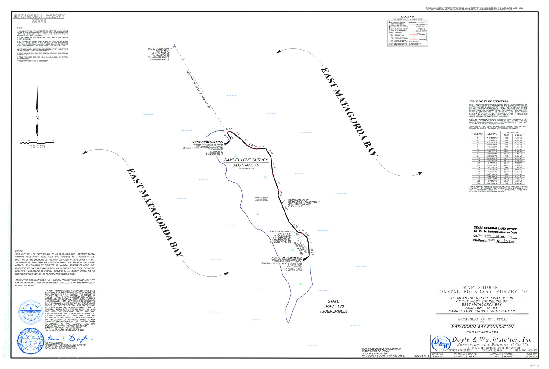
Matagorda County NRC Article 33.136 Sketch 19
Map showing Coastal Boundary Survey of the mean higher high water line of the west shoreline of East Matagorda Bay adjacent to the Samuel Love Survey, Abstract 59
-
Map/Doc
97268
-
Collection
General Map Collection
-
Object Dates
12/1/2023 (Creation Date)
6/13/2024 (File Date)
8/23/2023 (Survey Date)
1/18/2024 (Revision Date)
-
People and Organizations
Kim Thomas Doyle (Surveyor/Engineer)
-
Counties
Matagorda
-
Subjects
Surveying CBS
-
Scale
1"= 30 feet
-
Comments
Project: Matagorda Bay Foundation - Hog Island Area, Matagorda County
Project No.: TGLO CMP No. 23-020-013-D607
Part of: General Map Collection
Comanche County

Print $20.00
- Digital $50.00
Comanche County
1896
Size 41.7 x 44.8 inches
Map/Doc 4736
Parker County Sketch File 18

Print $4.00
- Digital $50.00
Parker County Sketch File 18
1876
Size 8.9 x 6.3 inches
Map/Doc 33554
Terrell County Working Sketch 84c

Print $20.00
- Digital $50.00
Terrell County Working Sketch 84c
Size 18.2 x 31.3 inches
Map/Doc 69607
Atascosa County Rolled Sketch 19

Print $20.00
- Digital $50.00
Atascosa County Rolled Sketch 19
1955
Size 22.1 x 18.3 inches
Map/Doc 5099
[Rosebud Station Map - Tracks and Structures - Lands, San Antonio and Aransas Pass Railway Co.]
![62566, [Rosebud Station Map - Tracks and Structures - Lands, San Antonio and Aransas Pass Railway Co.], General Map Collection](https://historictexasmaps.com/wmedia_w700/maps/62566.tif.jpg)
Print $4.00
- Digital $50.00
[Rosebud Station Map - Tracks and Structures - Lands, San Antonio and Aransas Pass Railway Co.]
1919
Size 11.7 x 18.6 inches
Map/Doc 62566
Map of DeWitt County

Print $20.00
- Digital $50.00
Map of DeWitt County
1881
Size 21.7 x 24.3 inches
Map/Doc 3478
Kendall County Sketch File 1

Print $4.00
- Digital $50.00
Kendall County Sketch File 1
Size 9.6 x 8.3 inches
Map/Doc 28671
Morris County Rolled Sketch 2A

Print $20.00
- Digital $50.00
Morris County Rolled Sketch 2A
Size 24.4 x 19.2 inches
Map/Doc 10271
Liberty County Sketch File 28

Print $6.00
- Digital $50.00
Liberty County Sketch File 28
Size 5.2 x 8.0 inches
Map/Doc 29952
Flight Mission No. CRC-2R, Frame 191, Chambers County

Print $20.00
- Digital $50.00
Flight Mission No. CRC-2R, Frame 191, Chambers County
1956
Size 18.6 x 22.4 inches
Map/Doc 84769
Eastland County Sketch File 13

Print $4.00
- Digital $50.00
Eastland County Sketch File 13
1887
Size 8.3 x 13.0 inches
Map/Doc 21593
Borden County Rolled Sketch 10

Print $40.00
- Digital $50.00
Borden County Rolled Sketch 10
1952
Size 110.6 x 29.8 inches
Map/Doc 8449
You may also like
Part of Garza, Crosby, Lynn, and Lubbock Counties

Print $20.00
- Digital $50.00
Part of Garza, Crosby, Lynn, and Lubbock Counties
1912
Size 25.3 x 20.0 inches
Map/Doc 91312
C. B. Livestock Co.'s West-Ranch, Bailey County, Texas

Print $2.00
- Digital $50.00
C. B. Livestock Co.'s West-Ranch, Bailey County, Texas
Size 11.2 x 8.9 inches
Map/Doc 90381
[East Line & Red River Railroad from Sulphur Springs to Jefferson]
![64769, [East Line & Red River Railroad from Sulphur Springs to Jefferson], General Map Collection](https://historictexasmaps.com/wmedia_w700/maps/64769.tif.jpg)
Print $20.00
- Digital $50.00
[East Line & Red River Railroad from Sulphur Springs to Jefferson]
1879
Size 37.8 x 33.6 inches
Map/Doc 64769
Leon County Rolled Sketch 17

Print $20.00
- Digital $50.00
Leon County Rolled Sketch 17
1981
Size 25.2 x 33.4 inches
Map/Doc 6602
The Coast of Texas

Print $20.00
- Digital $50.00
The Coast of Texas
1844
Size 18.3 x 26.9 inches
Map/Doc 72697
Flight Mission No. BRE-2P, Frame 41, Nueces County

Print $20.00
- Digital $50.00
Flight Mission No. BRE-2P, Frame 41, Nueces County
1956
Size 18.5 x 22.4 inches
Map/Doc 86743
Refugio County

Print $20.00
- Digital $50.00
Refugio County
1872
Size 17.6 x 22.9 inches
Map/Doc 3987
Real County Working Sketch 62

Print $4.00
- Digital $50.00
Real County Working Sketch 62
Size 26.4 x 23.2 inches
Map/Doc 71954
Hudspeth County Sketch File 23

Print $20.00
- Digital $50.00
Hudspeth County Sketch File 23
1935
Size 15.1 x 26.9 inches
Map/Doc 11801
[Blocks A, RG, O, B, S and 11]
![92858, [Blocks A, RG, O, B, S and 11], Twichell Survey Records](https://historictexasmaps.com/wmedia_w700/maps/92858-1.tif.jpg)
Print $20.00
- Digital $50.00
[Blocks A, RG, O, B, S and 11]
1921
Size 25.2 x 15.5 inches
Map/Doc 92858
Leon County Working Sketch 60

Print $5.00
- Digital $50.00
Leon County Working Sketch 60
2005
Size 20.7 x 31.3 inches
Map/Doc 83575
Gregg County Sketch File 1F

Print $4.00
- Digital $50.00
Gregg County Sketch File 1F
1850
Size 12.2 x 7.8 inches
Map/Doc 24547