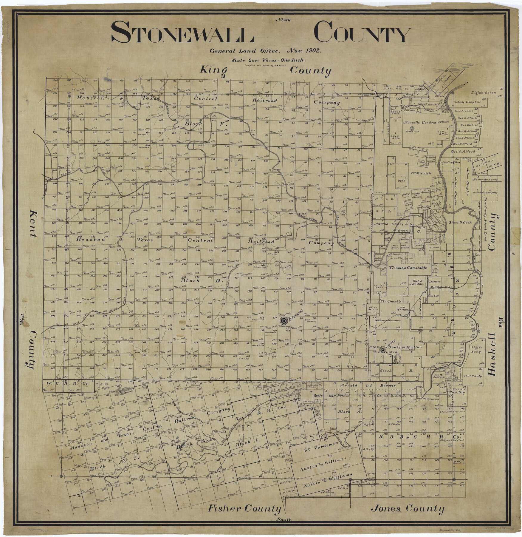
Stonewall County
-
Map/Doc
63049
-
Collection
General Map Collection
-
Object Dates
1902 (Creation Date)
-
People and Organizations
Texas General Land Office (Publisher)
Jourdan W. Morris (Compiler)
Jourdan W. Morris (Draftsman)
-
Counties
Stonewall
-
Subjects
County
-
Height x Width
39.6 x 38.5 inches
100.6 x 97.8 cm
Part of: General Map Collection
Nolan County Sketch File B

Print $20.00
- Digital $50.00
Nolan County Sketch File B
1902
Size 12.0 x 21.5 inches
Map/Doc 42171

Map of Randall County

Print $20.00
- Digital $50.00
Map of Randall County
1893
Size 26.5 x 20.0 inches
Map/Doc 73338
Flight Mission No. BRE-1P, Frame 152, Nueces County

Print $20.00
- Digital $50.00
Flight Mission No. BRE-1P, Frame 152, Nueces County
1956
Size 18.4 x 22.3 inches
Map/Doc 86712
Sutton County Working Sketch 21

Print $20.00
- Digital $50.00
Sutton County Working Sketch 21
1978
Size 22.3 x 26.1 inches
Map/Doc 62364
Dickens County Sketch File 1a

Print $40.00
- Digital $50.00
Dickens County Sketch File 1a
1879
Size 16.8 x 13.8 inches
Map/Doc 20948
Survey of 77 Blocks, State University Land

Survey of 77 Blocks, State University Land
1884
Size 13.5 x 8.5 inches
Map/Doc 81693
Geological Map of Texas

Print $20.00
- Digital $50.00
Geological Map of Texas
1919
Size 34.9 x 36.8 inches
Map/Doc 94091
Wood County Working Sketch 22

Print $20.00
- Digital $50.00
Wood County Working Sketch 22
1962
Size 45.9 x 36.6 inches
Map/Doc 62022
Angelina County Working Sketch 54

Print $20.00
- Digital $50.00
Angelina County Working Sketch 54
1989
Size 31.6 x 26.9 inches
Map/Doc 67138
Crockett County Rolled Sketch 48

Print $20.00
- Digital $50.00
Crockett County Rolled Sketch 48
1939
Size 30.0 x 40.3 inches
Map/Doc 8712
Hudspeth County Sketch File 37

Print $80.00
- Digital $50.00
Hudspeth County Sketch File 37
Size 12.5 x 98.3 inches
Map/Doc 27008
You may also like
The Republic of Texas, March 2, 1836 - February 19, 1846

The Republic of Texas, March 2, 1836 - February 19, 1846
1972
Size 23.4 x 18.3 inches
Map/Doc 2109
The Republic County of Fort Bend. February 5, 1840

Print $20.00
The Republic County of Fort Bend. February 5, 1840
2020
Size 14.7 x 21.6 inches
Map/Doc 96139
Flight Mission No. CUG-3P, Frame 192, Kleberg County

Print $20.00
- Digital $50.00
Flight Mission No. CUG-3P, Frame 192, Kleberg County
1956
Size 18.4 x 22.2 inches
Map/Doc 86296
Map of Hemisfair '68 and Downtown San Antonio compliments of the Pearl Brewing Company

Print $3.00
- Digital $50.00
Map of Hemisfair '68 and Downtown San Antonio compliments of the Pearl Brewing Company
1968
Size 5.9 x 11.3 inches
Map/Doc 94792
Boundary Between the United States & Mexico Agreed upon by the Joint Commission under the Treaty of Guadalupe Hidalgo

Print $4.00
- Digital $50.00
Boundary Between the United States & Mexico Agreed upon by the Joint Commission under the Treaty of Guadalupe Hidalgo
1853
Size 18.3 x 26.8 inches
Map/Doc 72881
Winkler County Working Sketch 12

Print $40.00
- Digital $50.00
Winkler County Working Sketch 12
1961
Size 59.3 x 50.0 inches
Map/Doc 72606
Map of Colorado City on the west bank of the Colorado River at the La Bahia crossing

Print $20.00
Map of Colorado City on the west bank of the Colorado River at the La Bahia crossing
1841
Size 24.4 x 32.5 inches
Map/Doc 94750
Map of Swisher County

Print $40.00
- Digital $50.00
Map of Swisher County
1900
Size 48.5 x 41.1 inches
Map/Doc 16890
Flight Mission No. DAH-9M, Frame 202, Orange County

Print $20.00
- Digital $50.00
Flight Mission No. DAH-9M, Frame 202, Orange County
1953
Size 18.5 x 22.6 inches
Map/Doc 86870
Menard County Working Sketch 10

Print $20.00
- Digital $50.00
Menard County Working Sketch 10
1938
Size 21.8 x 18.5 inches
Map/Doc 70957
Val Verde County Sketch File 48

Print $20.00
- Digital $50.00
Val Verde County Sketch File 48
1950
Size 18.2 x 28.9 inches
Map/Doc 12589
Nueces County Sketch File 64

Print $10.00
- Digital $50.00
Nueces County Sketch File 64
1979
Size 11.2 x 8.6 inches
Map/Doc 32975