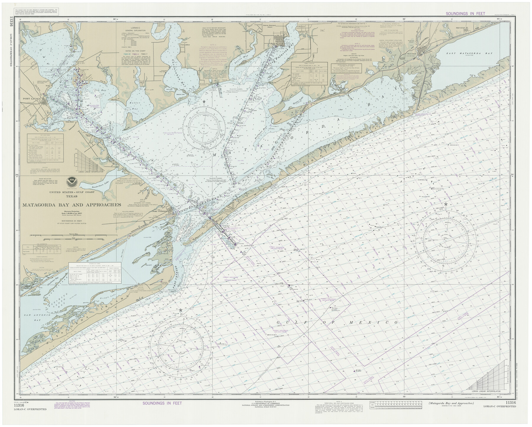
Matagorda Bay and Approaches
K-6-1284a
-
Map/Doc
73388
-
Collection
General Map Collection
-
Object Dates
1982/6/26 (Creation Date)
-
Counties
Matagorda Calhoun Victoria Jackson
-
Subjects
Nautical Charts
-
Height x Width
36.2 x 44.9 inches
91.9 x 114.0 cm
Part of: General Map Collection
Texas Intracoastal Waterway - Stover Point to Port Brownsville including Brazos Santiago
![73521, Texas Intracoastal Waterway - Stover Point to Port Brownsville including Brazos Santiago, General Map Collection](https://historictexasmaps.com/wmedia_w700/maps/73521.tif.jpg)
Print $20.00
- Digital $50.00
Texas Intracoastal Waterway - Stover Point to Port Brownsville including Brazos Santiago
1965
Size 27.5 x 38.9 inches
Map/Doc 73521
Brazoria County State Real Property Sketch 2
![83356, Brazoria County State Real Property Sketch 2, General Map Collection](https://historictexasmaps.com/wmedia_w700/pdf_converted_jpg/qi_pdf_thumbnail_30712.jpg)
Print $60.00
- Digital $50.00
Brazoria County State Real Property Sketch 2
2003
Size 31.0 x 42.9 inches
Map/Doc 83356
Flight Mission No. DQO-11K, Frame 20, Galveston County
![85215, Flight Mission No. DQO-11K, Frame 20, Galveston County, General Map Collection](https://historictexasmaps.com/wmedia_w700/pdf_converted_jpg/qi_pdf_thumbnail_32423.jpg)
Print $20.00
- Digital $50.00
Flight Mission No. DQO-11K, Frame 20, Galveston County
1952
Size 18.8 x 22.4 inches
Map/Doc 85215
Mills County Sketch File 18
![31668, Mills County Sketch File 18, General Map Collection](https://historictexasmaps.com/wmedia_w700/pdf_converted_jpg/qi_pdf_thumbnail_13106.jpg)
Print $4.00
- Digital $50.00
Mills County Sketch File 18
1872
Size 12.1 x 8.1 inches
Map/Doc 31668
Archer County Working Sketch 17
![67158, Archer County Working Sketch 17, General Map Collection](https://historictexasmaps.com/wmedia_w700/maps/67158.tif.jpg)
Print $3.00
- Digital $50.00
Archer County Working Sketch 17
1951
Size 10.7 x 12.2 inches
Map/Doc 67158
Robertson County Working Sketch Graphic Index
![76685, Robertson County Working Sketch Graphic Index, General Map Collection](https://historictexasmaps.com/wmedia_w700/maps/76685.tif.jpg)
Print $20.00
- Digital $50.00
Robertson County Working Sketch Graphic Index
1945
Size 46.8 x 37.9 inches
Map/Doc 76685
Nueces County Aerial Photograph Index Sheet 21
![86842, Nueces County Aerial Photograph Index Sheet 21, General Map Collection](https://historictexasmaps.com/wmedia_w700/pdf_converted_jpg/qi_pdf_thumbnail_33979.jpg)
Print $20.00
- Digital $50.00
Nueces County Aerial Photograph Index Sheet 21
1938
Size 24.3 x 20.2 inches
Map/Doc 86842
Denton County Sketch File 19
![20733, Denton County Sketch File 19, General Map Collection](https://historictexasmaps.com/wmedia_w700/pdf_converted_jpg/qi_pdf_thumbnail_10687.jpg)
Print $10.00
- Digital $50.00
Denton County Sketch File 19
Size 10.0 x 7.3 inches
Map/Doc 20733
Val Verde County Working Sketch 103
![72238, Val Verde County Working Sketch 103, General Map Collection](https://historictexasmaps.com/wmedia_w700/maps/72238.tif.jpg)
Print $20.00
- Digital $50.00
Val Verde County Working Sketch 103
Size 37.1 x 39.9 inches
Map/Doc 72238
Reeves County Rolled Sketch 39
![96570, Reeves County Rolled Sketch 39, General Map Collection](https://historictexasmaps.com/wmedia_w700/maps/96570.tif.jpg)
Print $20.00
- Digital $50.00
Reeves County Rolled Sketch 39
2018
Size 25.0 x 36.5 inches
Map/Doc 96570
Crockett County Sketch File 33
![19731, Crockett County Sketch File 33, General Map Collection](https://historictexasmaps.com/wmedia_w700/pdf_converted_jpg/qi_pdf_thumbnail_10481.jpg)
Print $30.00
- Digital $50.00
Crockett County Sketch File 33
1883
Size 13.0 x 8.2 inches
Map/Doc 19731
You may also like
Outer Continental Shelf Leasing Maps (Texas Offshore Operations)
![75842, Outer Continental Shelf Leasing Maps (Texas Offshore Operations), General Map Collection](https://historictexasmaps.com/wmedia_w700/maps/75842.tif.jpg)
Print $20.00
- Digital $50.00
Outer Continental Shelf Leasing Maps (Texas Offshore Operations)
Size 17.2 x 13.7 inches
Map/Doc 75842
[Galveston, Harrisburg & San Antonio through El Paso County]
![64005, [Galveston, Harrisburg & San Antonio through El Paso County], General Map Collection](https://historictexasmaps.com/wmedia_w700/maps/64005.tif.jpg)
Print $20.00
- Digital $50.00
[Galveston, Harrisburg & San Antonio through El Paso County]
1906
Size 13.3 x 33.6 inches
Map/Doc 64005
Val Verde County Sketch File 44A
![39311, Val Verde County Sketch File 44a, General Map Collection](https://historictexasmaps.com/wmedia_w700/pdf_converted_jpg/qi_pdf_thumbnail_14808.jpg)
Print $10.00
- Digital $50.00
Val Verde County Sketch File 44A
1940
Size 14.5 x 8.8 inches
Map/Doc 39311
Dickens County Working Sketch Graphic Index
![76523, Dickens County Working Sketch Graphic Index, General Map Collection](https://historictexasmaps.com/wmedia_w700/maps/76523.tif.jpg)
Print $20.00
- Digital $50.00
Dickens County Working Sketch Graphic Index
1963
Size 42.5 x 33.6 inches
Map/Doc 76523
Young County Sketch File 12
![40876, Young County Sketch File 12, General Map Collection](https://historictexasmaps.com/wmedia_w700/pdf_converted_jpg/qi_pdf_thumbnail_15215.jpg)
Print $4.00
- Digital $50.00
Young County Sketch File 12
1889
Size 8.5 x 13.6 inches
Map/Doc 40876
Lynn County Rolled Sketch W
![6655, Lynn County Rolled Sketch W, General Map Collection](https://historictexasmaps.com/wmedia_w700/maps/6655.tif.jpg)
Print $20.00
- Digital $50.00
Lynn County Rolled Sketch W
Size 23.0 x 40.0 inches
Map/Doc 6655
Sutton County Working Sketch 8
![62351, Sutton County Working Sketch 8, General Map Collection](https://historictexasmaps.com/wmedia_w700/maps/62351.tif.jpg)
Print $20.00
- Digital $50.00
Sutton County Working Sketch 8
Size 14.2 x 21.6 inches
Map/Doc 62351
Flight Mission No. DQN-3K, Frame 7, Calhoun County
![84339, Flight Mission No. DQN-3K, Frame 7, Calhoun County, General Map Collection](https://historictexasmaps.com/wmedia_w700/pdf_converted_jpg/qi_pdf_thumbnail_31557.jpg)
Print $20.00
- Digital $50.00
Flight Mission No. DQN-3K, Frame 7, Calhoun County
1953
Size 18.6 x 22.2 inches
Map/Doc 84339
Concho County Sketch File 18
![19137, Concho County Sketch File 18, General Map Collection](https://historictexasmaps.com/wmedia_w700/pdf_converted_jpg/qi_pdf_thumbnail_10336.jpg)
Print $32.00
- Digital $50.00
Concho County Sketch File 18
1898
Size 9.1 x 4.4 inches
Map/Doc 19137
[Surveying Sketch of Encibio Almaguie, T. W. N. G. R. R. Co., et al in Hutchinson County, Texas]
![93791, [Surveying Sketch of Encibio Almaguie, T. W. N. G. R. R. Co., et al in Hutchinson County, Texas], Maddox Collection](https://historictexasmaps.com/wmedia_w700/maps/93791.tif.jpg)
Print $20.00
- Digital $50.00
[Surveying Sketch of Encibio Almaguie, T. W. N. G. R. R. Co., et al in Hutchinson County, Texas]
Map/Doc 93791
[Surveying Sketch of Buckman, et al in Unknown County]
![498, [Surveying Sketch of Buckman, et al in Unknown County], Maddox Collection](https://historictexasmaps.com/wmedia_w700/maps/498.tif.jpg)
Print $3.00
- Digital $50.00
[Surveying Sketch of Buckman, et al in Unknown County]
Size 11.7 x 11.9 inches
Map/Doc 498